
ABSTRACT
The geological map L-47-V at a scale 1:500,000 covers part of Mongolian Altaids with ophiolite fragments in southern Central Asian Orogenic Belt in SW Mongolia. This region has a basin and range topography with Neoproterozoic and Palaeozoic units exposed at NW–SE trending ranges rising along major intracontinental faults and with intermontane basins filled by Mesozoic and Cenozoic sediments in between. The map shows clear N–S tectonic zonation featuring the northerly Precambrian Baidrag microcontinent, the lower Palaeozoic Lake Zone in the centre and the southerly Palaeozoic Gobi-Altai and Trans-Altai zones. Gravity highs are located in the SW part of the map and low to intermediate Bouguer anomalies in the NE part. NW–SE trends of gravity anomalies correlate well with the contact between the Trans-Altai and the Gobi-Altai zones but the important first-order geological boundary between the Lake and Gobi-Altai zones cannot be delineated by the gravity gradients.
1. Introduction
Geological map is a scaled-down interpretation of the structure of a selected area of the uppermost part of the Earth’s crust. Exploration of natural resources and identification of geological hazards are the most important functions of the geological maps. They represent also an indispensable tool allowing the reconstruction of the geological history of the Earth, and provide a solution for theoretical and applied problems allowing further advances in the Earth Sciences. This is obvious especially in vast and remote regions in Central Asia rich in raw materials but rather poor in available modern geological maps.
The Central Asian Orogenic Belt (CAOB) is represented by numerous lithotectonic zones accreted during the Late Proterozoic to Phanerozoic times around the Siberian continental nuclei (CitationBadarch, Cunningham, & Windley, 2002; CitationSengör, Nataĺin, & Burtman, 1993). Small-scale geological maps are one of the most important bases for mutual correlation of geological units forming these zones and to better understand their assembly during the accretion and subsequent collisional reworking (e.g. CitationBroussolle et al., 2019; CitationKröner et al., 2010; CitationLehmann et al., 2010). For this purpose, we produced a 1:500,000 scale map sheet L-47-V covering c. 53 000 km2 in the Bayankhongor and Gobi Altai provinces of SW Mongolia. In this critical region of the Mongolian Altaids, the Neoproterozoic to upper Palaeozoic geological units are exposed in NW–SE trending mountain ranges, while Mesozoic and Cenozoic sediments fill basins among them.
This map sheet demonstrates the efficiency of using satellite imagery and geophysics together with field, current geochronological and geochemical data to produce reliable geological maps in remote regions with a high ore-deposit potential.
2. Methods
2.1. Map construction
The topographic base of the map was derived from the ASTER GDEM V2 of 30 × 30 m spatial resolution. The shaded relief was prepared using 3D Analyst tool of ArcGIS in four layers with azimuths of 20, 60, 150, and 330° and constant Sun angle of 30°. The course of rivers was redrafted from the Landsat 8 imagery, together with roads and summits which were traced from the freely available Soviet Military Topographic Maps and modified according to the real field GPS tracks.
Geological boundaries were interpreted from the Landsat 8 scenes p137-138r28-29. These satellite images, free of cloud cover for the year 2015, were downloaded from the USGS web site and processed by image-enhancement techniques using Grass GIS and Python. The principal component analysis and factor loading analysis with emphasis on geological information showed that the band combination (6, 7, 4) had the highest contrast that could be further enhanced by decorrelation stretch. Band ratio combination (4/3, 6/2, 7/4) showed prime contrast for geological information and formed the input data for visual classification. For presentation on a map sheet the combination (2, 4, 5) revealing well contrast between major geological units has been selected.
2.2. Geological data
The geological interpretation of Landsat 8 imagery was supported by detailed field records along the main roads and valleys, and by our own geochemical and radiometric data completed with published data (see CitationBuriánek et al., 2017; CitationHanžl et al., 2016; CitationJiang et al., 2017; CitationKröner et al., 2010; CitationLehmann et al., 2017 and CitationJanoušek et al., 2018 for review). Subdivision of major geological units of southern Mongolia to tectonic zones (CitationMossakovsky, Ruzhentsev, Samygin, & Kheraskova, 1994) was preferred to ‘terrane division’ of CitationBadarch et al. (2002). The latter is not consistent with new geological and geochronological data describing giant belts of Cambro–Ordovician magmatic arc or lower Palaeozoic accretionary wedge continuing from Mongolia towards Russian and Chinese Altai (e.g. CitationJanoušek et al., 2014; CitationJiang et al., 2017; CitationKröner et al., 2010). The names of the geological units and lithotectonic zones generally respect the traditional terminology used by CitationMarkova (1975) and by the reports of the geological maps at a scale 1:200,000 (CitationRauzer et al., 1987; CitationTogtokh, Banzragch, Gunbileg, Amgalanbayar, & Altangerel, 2014; CitationUfliand, Filippova, Chekhovich, Durante, & Savin, 1966). The geological units were depicted according to the lithostratigraphy and tectonic affiliation to the pre-Mesozoic units, Mesozoic and Cenozoic cover. Plutonic rocks and upper Palaeozoic volcaniclastic complexes are described separately.
The lithostratigraphic columns were constructed according to the observed field relationships and the published lithostratigraphic data. The chronological assignment of the geological events was carried out according to the published data cited in the text and completed by unpublished radiometric data of the Czech Geological Survey summarized in the Appendix 1.
2.3. Gravimetry
The Bouguer gravity anomalies are available at a spatial resolution of 2.5 × 2.5 arc minute from the Earth Global Model 08 (EGM08) that contains airborne gravity data over the whole Mongolia (CitationPavlis, Holmes, Kenyon, & Factor, 2012). The interpretation from different data filtering techniques of the Bouguer anomaly and the isostatic residual data combined with geological information was carried out to interpret the gravity lineament network and cross-checked the recurrence of the different lineaments. A geophysical lineament or a structural alignment corresponds to heterogeneities in the crust (faults, contacts or other discontinuities). We applied a series of filtering to the Bouguer anomaly map, such as first vertical derivative and horizontal gradient (CitationBlakely & Simpson, 1986; CitationCordell, 1979), Tilt angle (CitationDogru, Pamukcu, & Ozsoz, 2017; CitationMiller & Singh, 1994) and analytic signal (CitationNabighian, 1974) in order to highlight the contacts and the edges of gravity sources by outlining the trends of the lineaments. The horizontal gradient magnitude with different low-pass filtering and the analytic signal were applied and juxtaposed (see Appendix 2).
3. Geology
3.1. Regional setting
The studied section lies in the Mongolian part () of the CAOB (CitationMossakovsky et al., 1994; CitationWindley, Alexeiev, Xiao, Kröner, & Badarch, 2007). The area is bisected by the Main Mongolian Lineament (MML), interpreted as the main tectonic boundary separating the northerly Neoproterozoic domains affected by the Cambrian orogeny from the early Palaeozoic domains to the south (CitationBadarch et al., 2002; CitationJiang et al., 2017; CitationKröner et al., 2010; CitationRuzhentsev & Pospelov, 1992) subjected to Late Devonian to Triassic deformation, magmatism and metamorphism (CitationEdel, Schulmann, Hanžl, & Lexa, 2014; CitationLehmann et al., 2010; CitationNguyen et al., 2018; CitationXiao et al., 2009).
Figure 1. Geological position of Mongolia in the frame of CAOB, according to CitationNguyen et al. (2018), modified from CitationBuriánek et al. (2017).
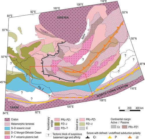
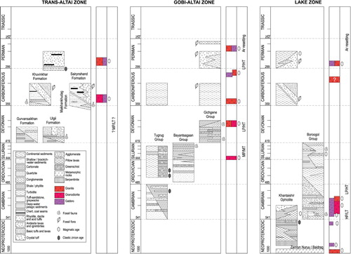
The map shows clear NE–SW tectonic zonation () in pre-Permian sequences ranging from the northerly Baidrag Block (Precambrian continent fragment), through the Lake Zone (Neoproterozoic – lower Palaeozoic accretionary wedge with ophiolite remnants) to the southerly Gobi-Altai Zone (lower to upper Palaeozoic accretionary wedge) and the Trans-Altai Zone (dominantly a Palaeozoic oceanic/island arc domain). The lithostratigraphic scheme in summarizes the characteristic rock associations in the main geological suites within the main lithotectonic zones.
Figure 2. Position of map sheet L-47-V within geotectonic map of SW Mongolia (modified from CitationNguyen et al., 2018).
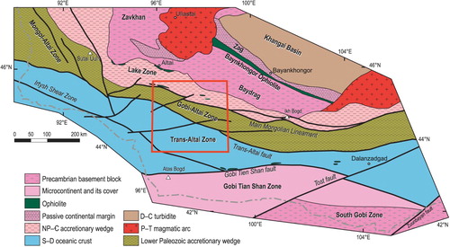
Figure 3. Lithostratigraphic scheme of the Trans-Altai, Gobi-Altai, and Lake zones. Metamorphism: H, M, L – high, medium, low; P, T – pressure, temperature.
3.2. Cenozoic cover
The area shows a basin and range fault-controlled topography where mountain ranges display an asymmetric character generally with steep N and NE slopes and peneplain remnants (plateau) relatively gently dipping towards S and SE. The present topography has developed in the Late Cenozoic transpressional regime as a distant response to the Indo–Eurasian collision (CitationCunningham, 2005). The kinematics of the Quaternary faults has been fundamentally controlled by structural trends in the pre-Mesozoic basement (CitationCunningham, 2010). The intermontane basins are dominantly filled by unsorted gravels with angular boulders of widespread alluvial fans terminating in axes of the depressions with playas. Locally preserved, non-lithified, relatively well sorted grey or reddish Paleogene and Neogene gravels and silts represent fluvial sediments.
3.3. Mesozoic cover
The Mesozoic sequences are represented by continental and deltaic intracontinental rift sediments of the Upper Jurassic–Lower Cretaceous ages in the rift-like zone (CitationKovalenko, Yarmolyuk, & Bogatikov, 1995; CitationYarmolyuk, 1983; CitationYarmolyuk, 1986). The sedimentation started with the Upper Jurassic poorly sorted proximal alluvial fan conglomerates to breccias progressively passing to the Lower Cretaceous conglomerates, sandstones, marls and mudstones locally with coal seams. The Cretaceous sediments formed in a continental fluvial and shallow lacustrine environment. Extrusions of basaltic andesite to trachybasalt lavas with characteristic within-plate geochemistry (CitationBuriánek, Hanžl, Erban, Gilíková, & Bolormaa, 2008) are common in the uppermost part of the sequence. The Upper Cretaceous sandstones and siltstones are preserved on the northern slopes of the Edren Range.
3.4. Upper Palaeozoic volcaniclastic complexes
The Lower Carboniferous terrestrial bimodal lavas and volcaniclastic rocks rim the southern margin of the Baidrag Block. The Permian bimodal volcano-plutonic association of alkaline affinity with common pyroclastic rocks and conglomerates in the uppermost part of the sequence follows the boundaries of the Lake Zone and the Baidrag Block in the so-called Gobi-Altai Rift (CitationKozlovsky et al., 2015). The remnants of vascular plants preserved in the volcaniclastic layers of the Khar Argalant Mts. belong to typical Lower to Middle Permian terrestrial associations with affinities to the Siberian palaeoflora (CitationBuriánek, Hanžl, Budil, & Gerdes, 2012).
3.5. Trans-Altai Zone
The southerly situated Trans-Altai Zone is separated from the Gobi-Altai Zone by a system of NW–SE trending faults and it is further sub-divided into the Khuvinkhar, Edren and Zuulun (Zoolen) subzones (CitationLehmann et al., 2010). The Khuvinkhar and Edren subzones consisting of early Devonian basic volcanic and volcaniclastic rocks with limestone layers, jasper and siliceous schists (CitationRuzhentsev & Pospelov, 1992) are exposed in the NW–SE trending Edren Range within the Gurvansaikhan and Ulgii formations. This sequence was interpreted as an island-arc dominated by basalts (CitationHendrix, Davis, Lamb, & Badarch, 2007). The ophiolitic character of the Zuulun Subzone exposed further to the SE was recognized according to the characteristic rock association (CitationRuzhentsev & Mossakovski, 1995) and their geochemical characteristics (CitationHelo et al., 2006).
However, bimodal Carboniferous volcanic and volcaniclastic rocks of the Khuvinkhar and Sairynshand formations representing dominant lithostratigraphic components of the Trans-Altai Zone, probably developed in a volcanic-arc setting (CitationNguyen et al., 2018). The Upper Devonian to Lower Carboniferous flysch sequence of the Maikhankhudag Formation is exposed in tectonic slices along the major tectonic zones on the SW slopes of the Edren Range and SW of the Tseel Unit.
3.6. Gobi-Altai Zone
The Gobi-Altai Zone is a complex assemblage recording evolution of an active continental margin of a giant Altai sedimentary wedge (CitationJiang et al., 2017; CitationSoejono et al., 2018) over the whole Palaeozoic. Its northern boundary is the MML while the southern one corresponds to the Trans-Altai fault zone along the SW slopes of the Mongolian Altai.
The oldest Tugrug Group is formed by monotonous Late Cambrian to Ordovician/Silurian silici- and volcaniclastic, slightly metamorphosed rocks. The Tugrug Group or its equivalents could represent protolith of the metamorphic rocks in the Tseel Complex exposed along the SW slopes of the Mongolian Altai range (CitationJiang et al., 2017). Metapelites reflecting the Barrovian metamorphism (CitationBurenjargal et al., 2014) contain gabbroic rocks of Devonian age (CitationBaikova & Amelin, 1994) and orthogneisses of Devonian protolith (CitationHanžl et al., 2016). The entire polymetamorphic complex was influenced by the Permian thermal event (CitationBurenjargal et al., 2016; CitationHanžl et al., 2017).
The Tugrug Group is unconformably covered by Silurian–Devonian limestones and bimodal volcanic rocks while the Lower Carboniferous flysch sediments are exposed along faults between major geological units of the Gobi-Altai Zone.
The Bayantsagaan Group of Ordovician to Silurian age is a monotonous terrigenous sequence predominantly composed of shales, aleurites and sandstones often with tuffitic admixture and limestone layers. It is exposed along the MML on the slopes of the Bayan Tsagaan Mt. and can be divided to the Ordovician Bayantsagaan, Lower–Middle Silurian Bayangobi and Middle–Upper Silurian Bayanlig and Khutagnuur formations (CitationMarkova & Sharkova, 1977; CitationRauzer et al., 1987).
The Lower Devonian Gichgene Group was described in the eastern Mongolian Altai (CitationZonenshain, 1970; CitationFilippova, Suetenko, & Levintov 1990). It lies generally north of the Tugrug Group in tectonic slices dismembered by sub-vertical anastomose shear zones and faults. The unit can be generally characterized as a volcanosedimentary complex including both basic and acid massive volcanic rocks together with pyroclastic rocks, and wide spectrum of sediments, usually with substantial volcanic admixture. Large cliffs of the limestones are characteristic of the whole sequence. The fossil associations indicate lateral transitions from shallow-water to relatively deeper environment with isolated shallow-water carbonate reefs. The rock associations and the calc-alkaline geochemistry of volcanic rocks point to an island-arc geotectonic context (CitationHanžl & Aichler, 2007).
3.7. Lake Zone
The Lake Zone has a complicated structure between Proterozoic fragments in the north and Palaeozoic sequences in the south. It is formed by Neoproterozoic–Cambrian ophiolite fragments, blocks of crystalline units and oceanic sediments in accretionary prisms (e. g. CitationBuriánek et al., 2017; CitationRuzhentsev & Burashnikov, 1995; CitationZonenshain & Kuzmin, 1978) intruded by the Cambrian plutonic rocks of the Ikh-Mongol Arc System (CitationJanoušek et al., 2018). In the south, it is separated from the Gobi-Altai Zone by the Cenozoic fault system corresponding to the MML. The northern boundary of the Lake Zone is characterized by tectonic emplacement of ophiolitic complexes and island-arc assemblages over the southern margin of the Precambrian Tuva-Mongol, Zavkhan, and Baidrag blocks (CitationKröner et al., 2010).
High-grade metamorphic rocks are preserved in the Zamtyn Nuruu Complex consisting of two parts: (1) mica schists belt with eclogite and serpentinite boudins reflecting the Early Cambrian HP metamorphism (CitationSkuzovatov, Shatsky, Dril, & Perepelov, 2018; CitationŠtípská et al., 2010) lying south of the Khantaishir ophiolite in the Erdene Uul area and thrusted over (2) the MT/MP metamorphic complex with conspicuous augen gneisses of the Tonian protolith (CitationBuriánek et al., 2017).
The Ediacaran Khantaishir ophiolite sequence with serpentinite and gabbro, pillow lavas, jasper and limestones is nearly completely preserved at the Erdene Uul (CitationBuriánek et al., 2017; CitationJian et al., 2014; CitationPerfiliev & Kheraskov, 1980). West of Burkhan Buudai Mt., it is characterized by a zone of tectonic melange with serpentinite, listvenite and exceptional blue schists (D. Buriánek pers. com.) while the southern part of the mountain is formed by Neoproterozoic silici- and volcaniclastic rocks with limestones and greenschists.
The lower Palaeozoic sequences of the Lake Zone belong to the Boroogol Group (Bezzubtsev 1960 in CitationMarkova, 1975) characterized by Cambrian limestones, conglomerates and volcaniclastic rocks on the base. The preservation and association of archaeocyathids indicate marine shallow-water, relatively quiet to moderately dynamic environment while the presence of agglomerate tuffs and even lahars prove aerial environment. Overlying Upper Cambrian to Silurian turbidites contain layers of deep-water limestones with cherts and pillow lavas.
3.8. Baidrag Zone
The Precambrian gneisses of the southernmost part of the Baidrag Block intruded by late Palaeozoic plutons are poorly exposed in the NE corner of the map. The Baidrag Block is a relic of a major Precambrian continent (e.g. CitationDemoux et al., 2009; CitationKozakov, Sal’nikova, et al., 2007; CitationLevashova, Gibsher, & Meert, 2011).
3.9. Plutonic rocks
Generally, plutonic rocks are extensively developed in the Lake, Gobi-Altai as well as in the Trans-Altai zones. The radiometric data from plutons (e.g. CitationBuriánek et al., 2008; CitationHanžl et al., 2008; CitationHrdličková et al., 2008; CitationHrdličková, Gerdes, Gilíková, Bat-Ulzii, & Hanžl, 2010; CitationJanoušek et al., 2018; CitationKozakov, Kovach, et al., 2007; CitationLehmann et al., 2017; CitationYarmolyuk et al., 2008) indicate younging of intrusive rocks from north to south. The Cambrian–Ordovician arc-type gabbros, diorites, quartz-diorites and granodiorites are restricted to the northern Lake Zone. The Devonian granodiorites and granites and their metamorphosed equivalents constitute much of the Tseel Complex and locally intruded also the Tugrug Group of the Gobi-Altai Zone, and the Carboniferous to Permian plutons dominate the Trans-Altai Zone. However, Carboniferous and Permian granitic and, rarely, gabbroic massifs are widespread across all the three zones.
4. Interpretation of gravity data
4.1. Bouguer gravity anomaly map
The Bouguer gravity anomalies range from –303 mGal to –156 mGal and two NW–SE trending principal zones can be distinguished (a). The gravity high is characterized by large-amplitude and long-wavelength Bouguer gravity anomalies located in the southwestern part of the mapped area, whereas the northeast is characterized by low to intermediate Bouguer gravity anomalies of large amplitude and short wavelengths. However, the Bouguer anomaly map contains the long-wavelength signals commonly attributed to density contrasts at the upper mantle level, which tends to conceal the shorter-wavelength signal portraying density contrasts located in the crust.
Figure 4. (a) Bouguer gravity anomaly map with interpreted lineaments: black lines are the NW–SE lineaments while white lines represent the NE–SW lineaments and (b) Isostatic residual gravity anomaly map with the superimposed faults depicted from the geological map.
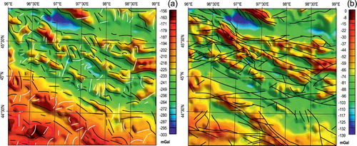
4.2. Isostatic residual gravity anomaly map
The resulting isostatic residual anomaly map displays short to intermediate wavelengths mostly corresponding to the signal at the upper and mid-crustal levels. It ranges from –139 mGal to 0 mGal (b) and does not show a distinct difference between the northeastern and the southwestern sectors unlike the Bouguer anomaly map. However, a rather strong and linearly regular gravity gradient can be noticed in the southwestern part of the area indicating a lateral change in the rock density at upper to middle crustal levels.
4.3. Interpretation of the gravity structures
The large gravity high of the Bouguer anomaly map located in the southwestern part of the area corresponds to the Trans-Altai Zone built by dense Palaeozoic oceanic lithologies. In contrast, the northeast is characterized by low to intermediate gravity values corresponding to the Lake and the Gobi-Altai zones. Removing the regional field, the isostatic residual gravity anomaly reveals a strong NW–SE gradient within the Trans-Altai Zone displaying an alternation of gravity high to the NE and low to the SW. The analysis of the lineaments identified by the multi-geophysical filters of gravity anomalies reveals two sets of lineaments: (1) the NW–SE striking lineaments of various lengths and (2) the NE–SW oriented lineaments highlighting discontinuities of the signals.
The Devonian and Permian volcanic rocks globally correlate with gravity highs, except for several outcrops of Early Carboniferous age. The sequence of the Khantaishir ophiolite characterized by pillow lavas and basic volcanic rocks is surprisingly not marked by strong gravity highs as expected but rather intermediate which suggests that the ophiolites are not deeply rooted. The Devonian to Carboniferous granodiorites to diorites correlate with high-amplitude isostatic residual anomalies. The Cretaceous and Cenozoic basins correspond to gravity lows although several small intermediate to high gravity anomalies can be distinguished that most probably correspond to the buried Palaeozoic rocks that crop out along the margins of the basins.
5. Conclusions
The presented geological map sheet L-47-V summarizes the recent geological field and analytical advances from the region between the Mongolian Altai in the north and Trans-Altai Gobi in the south. The geological units are exposed in NW–SE trending belts developed in one accretionary orogeny and serve as a unique basis for all future geodynamic models and interpretations. The new map complemented by a preliminary gravity analysis provides also a valuable source to define architecture of the southern tract of the CAOB in Mongolia.
Software
Geological map was constructed using ArcGIS 10.2.1 and improved in Adobe Illustrator CS 11. Landsat 8 data were processed using Grass GIS and Python. The gravity data were processed and filtered using Geosoft Oasismontaj 9.5. Then, the gravity map was exported to ArcMap 10.3 in order to perform the gravity lineament analysis.
Supplemental Material
Download Zip (2.7 MB)Hanzl_L-47-V_GM_revised.pdf
Download PDF (11.3 MB)Acknowledgments
We are thankful to M. Batsaikhan for logistic support of expeditions, T. Ganchuluun and A. Shagdarsuren for technical help in the field and Mongolian drivers for secure driving on hardly accessible roads. The discussions with O. Tumurtogoo over the first version of maps contributed to the understanding of geological relationships. The authors wish to thank H. Apps, O. Pamukçu and U. Bold for a critical review of the manuscript.
Disclosure statement
No potential conflict of interest was reported by the authors.
Additional information
Funding
Related Research Data
References
- Badarch, G. , Cunningham, W. D. , & Windley, B. F. (2002). A new terrane subdivision for Mongolia: Implications for the Phanerozoic crustal growth of Central Asia. Journal of Asian Earth Sciences , 21 (1), 87–110. doi: 10.1016/S1367-9120(02)00017-2
- Baikova, V. S. , & Amelin, Y. V. (1994). Sm–Nd age of Gashunuur dyke complex (Mongolia) (in Russian). Doklady Akademii Nauk, Geologia , 334 (3), 343–345.
- Blakely, R. J. , & Simpson, R. W. (1986). Approximating edges of source bodies from magnetic or gravity anomalies. Geophysics , 51 (7), 1494–1498. doi: 10.1190/1.1442197
- Broussolle, A. , Sun, M. , Schulmann, K. , Guy, A. , Aguilar, C. , Štípská, P. , … Xiao, W. (2019). Are the Chinese Altai “terranes” the result of juxtaposition of different crustal levels during Late Devonian and Permian orogenesis? Gondwana Research , 66 , 183–206. doi: 10.1016/J.GR.2018.11.003
- Burenjargal, U. , Okamoto, A. , Kuwatani, T. , Sakata, S. , Hirata, T. , & Tsuchiya, N. (2014). Thermal evolution of the Tseel Terrane, SW Mongolia and its relation to granitoid intrusions in the Central Asian Orogenic Belt. Journal of Metamorphic Geology , 32 (7), 765–790. doi: 10.1111/jmg.12090
- Burenjargal, U. , Okamoto, A. , Tsuchiya, N. , Uno, M. , Horie, K. , & Hokada, T. (2016). Contrasting geochemical signatures of Devonian and Permian granitoids from the Tseel Terrane, SW Mongolia. Journal of Geosciences , 61 (1), 51–66. doi: 10.3190/jgeosci.210
- Buriánek, D. , Hanžl, P. , Budil, P. , & Gerdes, A. (2012). Evolution of the early Permian volcanic-plutonic complex in the western part of the Permian Gobi-Altay rift (Khar Argalant Mts., SW Mongolia). Journal of Geosciences , 57 (2), 105–126. doi: 10.3190/jgeosci.116
- Buriánek, D. , Hanžl, P. , Erban, V. , Gilíková, H. , & Bolormaa, K. (2008). The Early Cretaceous volcanic activity in the western part of the Gobi-Altay rift (Shiliin Nuruu, SW Mongolia). Journal of Geosciences , 53 (2), 167–180. doi: 10.3190/jgeosci.026
- Buriánek, D. , Schulmann, K. , Hrdličková, K. , Hanžl, P. , Janoušek, V. , Gerdes, A. , & Lexa, O. (2017). Geochemical and geochronological constraints on distinct Early-Neoproterozoic and Cambrian accretionary events along southern margin of the Baydrag Continent in western Mongolia. Gondwana Research , 47 , 200–227. doi: 10.1016/J.GR.2016.09.008
- Cordell, L. (1979). Gravimetric expression of graben faulting in Santa Fe country and the Espanola Basin. In R. V. Ingersoll (Ed.), Guidebook to Santa Fe country: New Mexico Geol. Soc. Guidebook (pp. 59–64). Socorro: New Mexico Geological Society.
- Cunningham, D. (2005). Active intracontinental transpressional mountain building in the Mongolian Altai: Defining a new class of orogen. Earth and Planetary Science Letters , 240 (2), 436–444. doi: 10.1016/J.EPSL.2005.09.013
- Cunningham, D. (2010). Tectonic setting and structural evolution of the Late Cenozoic Gobi Altai Orogen. In T. M. Kusky , M. G. Zhai , & W. Xiao (Eds.), Geological Society, London, special Publications ( Vol. 338, pp. 361–387). London : Geological Society of London. doi: 10.1144/sp338.17
- Demoux, A. , Kröner, A. , Badarch, G. , Jian, P. , Tomurhuu, D. , & Wingate, M. T. D. (2009). Zircon ages from the Baydrag Block and the Bayankhongor Ophiolite Zone: Time constraints on Late Neoproterozoic to Cambrian subduction- and accretion-related Magmatism in Central Mongolia. The Journal of Geology , 117 (4), 377–397. doi: 10.1086/598947
- Dogru, F. , Pamukcu, O. , & Ozsoz, I. (2017). Application of tilt angle method to the Bouguer gravity data of Western Anatolia. Bulletin of the Mineral Research and Exploration , 155 , 45–45. doi: 10.19111/bulletinofmre.305177
- Edel, J. B. , Schulmann, K. , Hanžl, P. , & Lexa, O. (2014). Palaeomagnetic and structural constraints on 90° anticlockwise rotation in SW Mongolia during the Permo-Triassic: Implications for Altaid oroclinal bending. Preliminary palaeomagnetic results. Journal of Asian Earth Sciences , 94 , 157–171. doi: 10.1016/j.jseaes.2014.07.039
- Filippova, I. V. , Suetenko, O. D. , & Levintov, M. E. (1990). Explanation text to Geological map of Western Mongolia in the scale 1 : 500,000. The Volume 1, Stratigraphy. (in Russian) . Moscow : AN SSSR.
- Hanžl, P. , & Aichler, J. (2007). Geological survey of the Mongolian Altay at a scale of 1: 50,000 (Zamtyn Nuruu - 50) . Ulaanbaatar : Unpublished manuscript, Geological Information Centre, MRPAM.
- Hanžl, P. , Bat-Ulzii, D. , Rejchrt, M. , Košler, J. , Bolormaa, K. , & Hrdličková, K. (2008). Geology and geochemistry of the Palaeozoic plutonic bodies of the Trans-Altay Gobi, SW Mongolia: Implications for magmatic processes in an accreted volcanic-arc system. Journal of Geosciences , 53 (2), 201–234. doi: 10.3190/jgeosci.028
- Hanžl, P. , Krejčí, Z. , Altanbaatar, B. , Lexa, O. , Buriánek, D. , Janoušek, V. , … Hrdličková, K. (2017). Geology of the Gobi Altai and Tseel terranes in the central part of the Sagsai River Watershed, SE Mongolian Altai. Journal of Maps , 13 (2), 270–275. doi: 10.1080/17445647.2017.1297260
- Hanžl, P. , Schulmann, K. , Janoušek, V. , Lexa, O. , Hrdličková, K. , Jiang, Y. , … Erban, V. (2016). Making continental crust: Origin of Devonian orthogneisses from SE Mongolian Altai. Journal of Geosciences , 25–50. doi: 10.3190/jgeosci.206
- Helo, C. , Hegner, E. , Kröner, A. , Badarch, G. , Tomurtogoo, O. , Windley, B. F. , & Dulski, P. (2006). Geochemical signature of Paleozoic accretionary complexes of the Central Asian Orogenic Belt in South Mongolia: Constraints on arc environments and crustal growth. Chemical Geology , 227 (3–4), 236–257. doi: 10.1016/J.CHEMGEO.2005.10.003
- Hendrix, M. S. , Davis, G. A. , Lamb, M. A. , & Badarch, G. (2007). Paleozoic sedimentary basins and volcanic arc systems of southern Mongolia: New geochemical and petrographic constraints. In Paleozoic and Mesozoic Tectonic Evolution of Central and Eastern Asia: From Continental Assembly to Intracontinental Deformation. Geological Society of America. doi:10.1130/0-8137-1194-0.117
- Hrdličková, K. , Bolormaa, K. , Buriánek, D. , Hanžl, P. , Gerdes, A. , Janoušek, V. , … Janousek, V. (2008). Petrology and age of metamorphosed rock in tectonic slices inside the Palaeozoic sediments of the eastern Mongolian Altay, SW Mongolia. Journal of Geosciences , 53 (2), 139–165. doi: 10.3190/jgeosci.027
- Hrdličková, K. , Gerdes, A. , Gilíková, H. , Bat-Ulzii, D. , & Hanžl, P. (2010). Burd Gol granite massif as a product of the late Cambrian post-orogenic magmatism in the SE part of the Lake Zone, Gobi Altay, SW Mongolia. Journal of Geosciences , 55 (4), 369–386. doi: 10.3190/jgeosci.081
- Janoušek, V. , Jiang, Y. , Buriánek, D. , Schulmann, K. , Hanžl, P. , Soejono, I. , … Košler, J. (2018). Cambrian–ordovician magmatism of the Ikh-Mongol Arc system exemplified by the Khantaishir Magmatic Complex (Lake Zone, south–central Mongolia). Gondwana Research , 54 , 122–149. doi: 10.1016/j.gr.2017.10.003
- Janoušek, V. , Jiang, Y. , Schulmann, K. , Buriánek, D. , Hanžl, P. , Lexa, O. , … Battushig, A. (2014). The age, nature and likely genesis of the Cambrian Khantaishir arc, Lake Zone, Mongolia. Geophysical Research Abstracts , 16 , EGU2014–6108.
- Jian, P. , Kröner, A. , Jahn, B. , Windley, B. F. , Shi, Y. , Zhang, W. , … Liu, D. (2014). Zircon dating of Neoproterozoic and Cambrian ophiolites in West Mongolia and implications for the timing of orogenic processes in the central part of the Central Asian Orogenic Belt. Earth-Science Reviews , 133 , 62–93. doi: 10.1016/J.EARSCIREV.2014.02.006
- Jiang, Y. D. , Schulmann, K. , Kröner, A. , Sun, M. , Lexa, O. , Janoušek, V. , … Hanžl, P. (2017). Neoproterozoic–Early Paleozoic Peri-Pacific accretionary evolution of the Mongolian Collage System: Insights from geochemical and U–Pb zircon data from the Ordovician sedimentary wedge in the Mongolian Altai. Tectonics , 36 (11), 2305–2331. doi: 10.1002/2017TC004533
- Kovalenko, V. I. , Yarmolyuk, V. V. , & Bogatikov, O. A. (1995). Magmatism, Geodynamics and Metallogeny of Central Asia . Moscow : Miko Commercial Herald Publisher.
- Kozakov, I. K. , Sal’nikova, E. B. , Wang, T. , Didenko, A. N. , Plotkina, Y. V. , & Podkovyrov, V. N. (2007). Early Precambrian crystalline complexes of the Central Asian microcontinent: Age, sources, tectonic position. Stratigraphy and Geological Correlation , 15 (2), 121–140. doi: 10.1134/S0869593807020013
- Kozakov, I. K. , Kovach, V. P. , Bibikova, E. V. , Kirnozova, T. I. , Zagornaya, N. Y. , Plotkina, Y. V. , & Podkovyrov, V. N. (2007). Age and sources of granitoids in the junction zone of the Caledonides and Hercynides in southwestern Mongolia: Geodynamic implications (in Russian). Petrology , 15 , 126–150.
- Kozlovsky, A. M. , Yarmolyuk, V. V. , Salnikova, E. B. , Travin, A. V. , Kotov, A. B. , Plotkina, J. V. , … Savatenkov, V. M. (2015). Late Paleozoic anorogenic magmatism of the Gobi Altai (SW Mongolia): Tectonic position, geochronology and correlation with igneous activity of the Central Asian Orogenic Belt. Journal of Asian Earth Sciences , 113 , 524–541. doi: 10.1016/J.JSEAES.2015.01.013
- Kröner, A. , Lehmann, J. , Schulmann, K. , Demoux, A. , Lexa, O. , Tomurhuu, D. , … Wingate, M. T. D. (2010). Lithostratigraphic and geochronological constraints on the evolution of the Central Asian Orogenic Belt in SW Mongolia: Early Paleozoic rifting followed by Late Paleozoic accretion. American Journal of Science , 310 (7), 523–574. doi: 10.2475/07.2010.01
- Lehmann, J. , Schulmann, K. , Lexa, O. , Corsini, M. , Kröner, A. , Štípská, P. , … Otgonbator, D. (2010). Structural constraints on the evolution of the Central Asian Orogenic Belt in SW Mongolia. American Journal of Science , 310 (7), 575–628. doi: 10.2475/07.2010.02
- Lehmann, J. , Schulmann, K. , Lexa, O. , Závada, P. , Štípská, P. , Hasalová, P. , … Corsini, M. (2017). Detachment folding of partially molten crust in accretionary orogens: A new magma-enhanced vertical mass and heat transfer mechanism. Lithosphere , 9 (6), 889–909. doi: 10.1130/L670.1
- Levashova, N. M. , Gibsher, A. S. , & Meert, J. G. (2011). Precambrian microcontinents of the Ural–Mongolian Belt: New paleomagnetic and geochronological data. Geotectonics , 45 (1), 51–70. doi: 10.1134/s0016852111010043
- Markova, N. G. (1975). Stratigraphy of the lower and Middle Paleeozoic of Western Mongolia (in Russian). Transactions of Joint Soviet-Mongolian Scientific research Geological Expedition (Vol. 12) . Moscow : Nauka Press.
- Markova, N. G. , & Sharkova, T. T. (1977). Silurian and Devonian of South Mongolia (in Russian). In N. S. Zaitsev , & A. L. Yanshin (Eds.), Osnovnye problemy geologii Mongolii (Vol. 22, pp. 52–61). Moscow : Nauka.
- Miller, H. G. , & Singh, V. (1994). Potential field tilt—a new concept for location of potential field sources. Journal of Applied Geophysics , 32 (2–3), 213–217. doi: 10.1016/0926-9851(94)90022-1
- Mossakovsky, A. A. , Ruzhentsev, S. V. , Samygin, S. G. , & Kheraskova, T. N. (1994). Central Asian Fold Belt: Geodynamic evolution and formation history. Geotectonics , 27 , 445–474.
- Nabighian, M. N. (1974). Additional comments on the analytic signal of two-dimensional magnetic bodies with polygonal cross-section. Geophysics , 39 (1), 85–92. doi: 10.1190/1.1440416
- Nguyen, H. , Hanžl, P. , Janoušek, V. , Schulmann, K. , Ulrich, M. , Jiang, Y. , … Deiller, P. (2018). Geochemistry and geochronology of Mississippian volcanic rocks from SW Mongolia: Implications for terrane subdivision and magmatic arc activity in the Trans-Altai Zone. Journal of Asian Earth Sciences , 164 , 322–343. doi: 10.1016/j.jseaes.2018.06.029
- Pavlis, N. K. , Holmes, S. A. , Kenyon, S. C. , & Factor, J. K. (2012). The development and evaluation of the Earth Gravitational model 2008 (EGM2008). Journal of Geophysical Research , 117 , 1–38 B04406, doi:10.1029/2011JB008916
- Perfiliev, A. S. , & Kheraskov, N. N. (1980). The diabase complexes and the problem of the tectonic layering of the oceanic crust. In Peive A.V. (Ed.), Tectonic Layering of the Lithosphere Transactions (pp. 64–104, Vol. 343). Moscow : Nauka.
- Rauzer, A. A. , Zhanchiv, D. I. , Golyakov, V. I. , Ykhina, I. F. , Ivanov, I. G. , Tsukernik, A. B. , … Enkhsajkhan, T. (1987). Report on results of geological survey at a scale of 1 : 200,000, performed in southeast part of the Mongolian Altai, Mongolian National Republic in 1983–1986 (in Russsian) . Moscow : Tekhnoexport.
- Ruzhentsev, S. V. , & Burashnikov, V. V. (1995). Tectonics of the Salairides in Western Mongolia (in Russian). Geotectonics , 29 , 25–40.
- Ruzhentsev, S. V. , & Mossakovski, A. A. (1995). Geodynamics and tectonic evolution of the Central Asian Paleozoic structures as the result of the interaction between Pacific and Indo-Atlantic segments of the Earth. Geotectonics , 29 (4), 294–311.
- Ruzhentsev, S. V. , & Pospelov, I. I. (1992). The South-Mongolian Variscan fold system. (in Russian). Geotektonika , 30 (5), 45–62.
- Sengör, A. M. C. , Nataĺin, B. A. , & Burtman, V. S. (1993). Evolution of the Altaid tectonic collage and Paleozoic crustal growth in Eurasia. Nature , 364 , 299–307.
- Skuzovatov, S. Y. , Shatsky, V. S. , Dril, S. I. , & Perepelov, A. B. (2018). Elemental and isotopic (Nd–Sr–O) geochemistry of eclogites from the Zamtyn-Nuruu area (SW Mongolia): Crustal contribution and relation to Neoproterozoic subduction-accretion events. Journal of Asian Earth Sciences , 167 , 33–51. doi: 10.1016/J.JSEAES.2017.11.032
- Soejono, I. , Čáp, P. , Míková, J. , Janoušek, V. , Buriánek, D. , & Schulmann, K. (2018). Early Palaeozoic sedimentary record and provenance of flysch sequences in the Hovd Zone (western Mongolia): Implications for the geodynamic evolution of the Altai accretionary wedge system. Gondwana Research , 64 , 163–183. doi: 10.1016/J.GR.2018.07.005
- Štípská, P. , Schulmann, K. , Lehmann, J. , Corsini, M. , Lexa, O. , & Tomurhuu, D. (2010). Early Cambrian eclogites in SW Mongolia: Evidence that the Palaeo-Asian Ocean suture extends further east than expected. Journal of Metamorphic Geology , 28 (9), 915–933. doi: 10.1111/j.1525-1314.2010.00899.x
- Togtokh, J. , Banzragch, B. , Gunbileg, G. , Amgalanbayar, B. , & Altangerel, A. (2014). 1:200,000 scale geological mapping “SGM-200 Southern Mongolia-IV”, 2010-2013 (in Mongolian) . Ulaanbaatar : Geomin LLC.
- Ufliand, A. K. , Filippova, I. B. , Chekhovich, M. V. , Durante, M. V. , & Savin, V. E. (1966). Geological structure of western part of Gobi Altai, report on geological survey at a scale 1:1,000,000, part of map sheet L-47-G (in Russian) . Moscow : Tekhnoexport.
- Windley, B. F. , Alexeiev, D. , Xiao, W. , Kröner, A. , & Badarch, G. (2007). Tectonic models for the accretion of the Central Asian Orogenic Belt. Journal of the Geological Society of London , 164 (1), 31–47. doi: 10.1144/0016-76492006-022
- Xiao, W. J. , Windley, B. F. , Huang, B. C. , Han, C. M. , Yuan, C. , Chen, H. L. , … Li, J. L. (2009). End-Permian to mid-Triassic termination of the accretionary processes of the southern Altaids: Implications for the geodynamic evolution, Phanerozoic continental growth, and metallogeny of Central Asia. International Journal of Earth Sciences , 98 (6), 1189–1217. doi: 10.1007/s00531-008-0407-z
- Yarmolyuk, V. V. (1983). Late Palaeozoic volcanism of continental rift structures of Central Asia (in Russian) . Moscow : Nauka.
- Yarmolyuk, V. V. (1986). Speciality of structural position of continental rift structures of Mongolia (in Russian). Izv. Akad. Nauk SSSR, Ser. Geol , 9 , 3–15.
- Yarmolyuk, V. V. , Kovalenko, V. I. , Sal’nikova, E. B. , Kovach, V. P. , Kozlovsky, A. M. , Kotov, A. B. , & Lebedev, V. I. (2008). Geochronology of igneous rocks and formation of the Late Paleozoic south Mongolian active margin of the Siberian Continent. Stratigraphy and Geological Correlation , 16 (2), 162–181. doi: 10.1134/s0869593808020056
- Zonenshain, L. P. (1970). Summarizing report about results of group geological survey at a scale 1:1,000,000 done by expedition in years 1964-1966 (in Russian) . Moscow : Unpublished manuscript.
- Zonenshain, L. P. , & Kuzmin, M. I. (1978). The Khan-Taischir ophiolitic complex of Western Mongolia, its petrology, origin and comparison with other ophiolitic complexes. Contribution to Mineralogy and Petrology , 67 (1), 95–109. doi: 10.1007/BF00371637