
ABSTRACT
A 1:28,000-scale geoarchaeological map has been prepared for a large sector of the Ionian coastal belt of the Basilicata region, southern Italy, in order to investigate the relationships between the spatial distribution of archaeological sites of Greek settlement of Metapontum and the main landforms of this sector of the Bradano Foredeep. Archaeological investigation consists of an examination and a re-organisation of published data and new field surveys, which has allowed us to infer the relationships between landform elements and spatial distribution of about 1400 archaeological remnants of the Greek colony of Metapontum. Our results highlight a non-random distribution of the archaeological evidence and the strong influence of geomorphological features and processes on the settlement pattern.
1. Introduction
Geoarchaeology is a growing research discipline that draws advantages from the integration of data coming from different research fields such as geology, geomorphology, stratigraphy, mineralogy, geochemistry, geochronology and geophysics (CitationButzer, 2008 and references therein). Many works have focused on the multidisciplinary investigation of the interplay between humans and their environment in quite different geoarchaeological systems (sensu CitationSchiattarella, Giano, & Guarino, 1998) during the Holocene or shorter historical time-spans (see for example CitationBini, Baroni, & Ribolini, 2013; CitationBravi, Fuscaldo, Guarino, & Schiattarella, 2003; CitationPutignano, Orrù, & Schiattarella, 2014), testifying to the significant influence of landscape characteristics on human activities and settlement location (see for example CitationSchmaltz, Märker, Rosner, & Kandel, 2014). Geoarchaeological research aimed at the definition of the settlement rules has frequently exploited topographic analyses and the automatic extraction of DEM-derived parameters (see for example CitationDanese, Gioia, Biscione, & Masini, 2014; CitationDanese, Masini, Biscione, & Lasaponara, 2014; CitationDe Jaeger et al., 2000; CitationDi Leo et al., 2018; CitationGioia, Bavusi, Di Leo, Giammatteo, & Schiattarella, 2016; CitationSilbernagel, Martin, Gale, & Chen, 1997; CitationTurrero, Dominguez-Cuesta, Jimenez-Sanchez, & Garcia-Vazquez, 2013; among others) for the investigation of non-random distribution of archaeological sites and/or the development of predictive archaeology models (CitationVaughn & Crawford, 2009; CitationWarren & Asch, 2000). Geomorphological analysis and landform mapping represent an alternative but effective approach to develop innovative digital products aimed at the valorization of areas with high archaeological value (CitationBiscione, Danese, & Masini, 2018) or for solving geoarchaeological issues related to landscape archaeology, settlement patterns and the paths of ancient roads (see for example CitationGioia et al., 2016; CitationGioia, Del Lungo, Sannazzaro, & Lazzari, 2019; CitationVerhagen & Dragut, 2012).
In this work, we introduce a 1:28,000-scale geoarchaeological map of a large sector of the Ionian coastal belt of southern Italy, which coincides with the ancient territory of the Greek colony of Metapontum. The main purpose of this work is to emphasize the role of geomorphological analysis and detailed landform mapping as a key tool for investigating the possible influence of landscape features on the spatial and temporal evolution of ancient settlement.
2. Methods
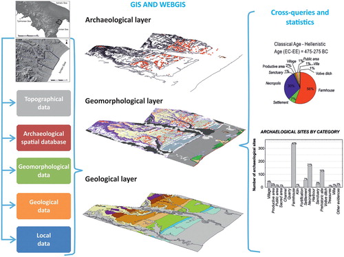
Geoarchaeological research has been carried out within the framework of the multidisciplinary MeTIBas project (the Italian acronyms for Innovative Methods and Technologies for the Cultural Heritages in the Basilicata region), funded by the European Community. We carried out geomorphological mapping, analysis of the topographic features of the landscape, definition of the Late Quaternary morpho-evolution of the area within the most reliable palaeoclimate scenarios, and GIS-supported statistical analysis of the spatial distribution of archaeological evidence in order to infer the settlement rules and the site dynamics of the ancient territory of Metapontum and its chora (i.e. the rural countryside of the colony, ). Statistical analysis of the spatial relationships between archaeological site locations and landform units allowed us to determine whether there is a significant correlation between site location and specific geomorphic elements.
Figure 1. Synoptic scheme of the acquired data.
2.1. The archaeological geodatabase
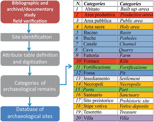
Archaeological investigation has been carried out through a re-examination of bibliographic and archival data (CitationAdamesteanu, 1971, Citation1986; CitationCarter, 1990, Citation2003, Citation2008; CitationCarter & Prieto, 2011; CitationChiartano, 1996; CitationDe Siena, 1986a, Citation1986b, Citation1999, Citation2001; among others) and new field surveys, which has allowed us to localize a total number of 1480 archaeological sites. Such a large amount of collected data has been stored in a GIS environment and grouped in the following categories (): village, farmhouse, necropolis, productive area, settlement, kiln, public area, sacred area, sanctuary, kiln, fortification, villa, votive ditch, channel, and prehistoric site. In order to investigate the settlement modifications and their possible relationships with environmental and geomorphological factors, evidence for the appearance and disappearance of sites in the archaeological record has been defined according to the following chronological scheme:
-
SP: Prehistory and Protohistory (Neolithic 10-5,7 Ka BP; Bronze age 4,2-3,1 Ka BP; Iron age 3,1-2,9 Ka BP);
-
FC: foundation of the colony (625-575 B.C. = 2,57-2,52 Ka BP);
-
EA-EC: from the Archaic to the Classical Age (575-525 B.C. = 2,52-2,47 Ka BP – 525–475 B.C. = 2,47-2,42 Ka BP);
-
EC-EE: from the Achaean colony to the Lucan invasion (475-275 B.C. = 2,42-2,22 Ka BP);
-
EE-ER: from the Hellenistic Age and Punic Wars (275-175 B.C. = 2,22-2,12 Ka BP) to the Roman Age (150-50 B.C. = 2,1-2,0 Ka BP).
Figure 2. Methodological approach used for the implementation of the archaeological database.
To assess settlement continuity through the entire chronological interval investigated we introduced a simple index, which we call the settlement continuity index (ISC, see inset in the main map), that is based on the relationship between the beginning of the settlement age and its time of abandonment (see the inset in the main map). The highest values of the ISC (=1) indicate a persistence of site occupancy from Prehistoric to Roman times, i.e. a settlement continuity through time.
2.2. Geological and geomorphological mapping
In order to extrapolate the possible relations between human and environment, the main geological and geomorphological features of the study area have been analyzed in depth and summarized in a layer format (specifically a vector shape with an associated relational queried database, ) stored in a GIS platform. The geological layer includes a geological map with a scale of 1:10,000 based on data from both available geological maps (CitationCilumbriello et al., 2010; CitationPescatore et al., 2009; CitationTropeano et al., 2013) and a new geological survey of the study area. The lithostratigraphic units characterizing the geology of the study area have been divided into three groups as follows: (i) continental deposits, (ii) coastal deposits, and (iii) marine deposits. Marine deposits belonging to the eleven orders of middle-late Pleistocene marine terraces are the most representative unit of the investigated area. They are described as alloformations, i.e. unconformity-bounded stratigraphic units (CitationSalvador, 1994) in the geological map (see inset in the main map).
A geomorphological map has been also drawn by field survey, multi-temporal aerial photointerpretation, and a critical review of data in the literature. Photo-interpretation was performed by analyzing the aerial photographs at a 1:33,000 scale (for the years 1955, 1974 and 1991). This approach allowed us to identify landforms produced by marine, fluvial and other surface processes and to investigate the spatial distribution of erosional and depositional processes of the study area. All the recognized landforms have been digitized using ArcGIS software and digital topographic base maps with a scale of 1:10,000, in a UTM coordinate system (WGS84 Zone 33 North). Moreover, a DEM with a spatial resolution of 5 m has been used to extrapolate altitude data and landscape features within the study area.
Geomorphological analyses have been mainly focused on the definition of the different generations of Quaternary marine and fluvial terraces. Analysis of Quaternary marine and fluvial terraces was based primarily on a detailed review of the literature describing these morphological features (CitationBelluomini et al., 2002; CitationBrückner, 1980; CitationCaputo, Bianca, & D’Onofrio, 2010; CitationCilumbriello et al., 2010; CitationPiccarreta, Caldara, Capolongo, & Boenzi, 2011; CitationSauer et al., 2010; CitationWestaway & Bridgland, 2007; CitationZander, Fulling, Bruckner, & Mastronuzzi, 2006). Following this review of the literature, we completed a new study of these landforms by undertaking field surveys and using aerial photos to create maps at 1:10,000 scale.
Fluvial terraces and deposits extend along the three main rivers (Cavone, Basento and Bradano rivers, from south to north), which crosscut the study area. Like the marine terraces, the fluvial terraces are distributed in different orders at different elevations. Among the main fluvial geomorphological features that have been surveyed, the abandoned channels on the present coastal plain were a particular focus of mapping, which may be useful to find an explanation to the displacements of several human settlements throughout history. On the other hand, the landforms generated by both erosional processes and gravity are represented in the categories ‘Areal forms and processes’ and ‘Landslides and gravitative processes’, respectively. In particular, the landslides have been characterized by the type of movement and state of activity. The analysis of the landslides started from the information provided by the ISPRA website (IFFI Project, see CitationLazzari, Gioia, & Anzidei, 2018), and was subsequently complemented by aerial-photo interpretation and field survey. For all the other features of fluvial, erosional and human origin, a completely new survey has been carried out based on a traditional integration of photo-interpretation and geomorphological field survey. Geomorphological mapping has also been focused on the delimitation of badlands and areas affected by severe rill and gully erosion. The mapping of fluvial-related processes includes alluvial terraces and floodplain depositional landforms and plano-altimetric anomalies of the fluvial network.
Mapped landforms, late Quaternary and historical coast-lines, and the geodatabase of archaeological features have been combined and integrated to produce the main map.
3. The geoarchaeological system of the study area
3.1. Geological setting and Quaternary morphotectonic evolution
The study area is localized along the Ionian coastal belt of the Basilicata region, southern Italy. From a geological viewpoint, it is located between the eastern front of the southern Apennine chain and the westernmost sector of the Apulia foreland and corresponds to the southernmost and youngest outcropping sector of the Bradano Foredeep. This foreland basin underwent a process of tectonic uplifting since the middle Pleistocene, which promoted the progressive emersion of the area and the formation of a staircase of marine terraces. Middle to Upper Pleistocene marine terraced deposits unconformably overlie a bedrock made by Lower Pleistocene marine grey-blue silty clays (CitationTropeano, Sabato, & Pieri, 2002). Marine terrace deposits consist of thin gravel and sand wedges organized in superimposed orders whereas marine clays largely crop out along the deeper incision of the fluvial net (CitationGioia, Schiattarella, & Giano, 2018). The marine Pliocene-Pleistocene formations are partially covered by the most recent, generally Holocene continental and transitional (marine-continental) deposits. The alluvial environments are represented by continental deposits, either located along the channels of the main rivers or on wide flood plains, whereas transitional deposits belong to delta and beach environments, whose depositional systems, during the late Holocene, prograded up to the present-day shoreline (CitationPescatore et al., 2009).
The main geomorphic element of the study area is the sequence of Middle to Late Pleistocene marine terraces occurring along the investigated 20 km-long Ionian coastal transect. Analysis of the spatial and vertical distribution of marine terrace staircase represents a key tool for reconstructing the tectonic evolution of this sector of southern Italy (CitationBelluomini et al., 2002; CitationBrückner, 1980; CitationCaputo et al., 2010; CitationCilumbriello et al., 2010; CitationCotecchia & Magri, 1967; CitationDe Santis, Caldara, Torres, Ortiz, & Sánchez-Palencia, 2018; CitationGioia et al., 2016; CitationSauer et al., 2010; CitationVezzani, 1967; CitationZander et al., 2006). Although the results are in some cases debated due to some limitations such as the difficulty in chronological attribution of different order of marine terraces and recognition of the inner edge of each terrace, morphotectonic analysis of both the marine terrace staircase (see CitationCaputo et al., 2010; CitationGioia et al., 2018) and drainage network morphometry (CitationGioia et al., 2018) suggests a recent tectonic evolution controlled by the activity of the blind thrust of the southern Apennines.
3.2. Historical outline
The first settlements in the Metapontum area date back to the Neolithic and become numerous in the Bronze and Iron Ages. Archaeological investigations of the Termitito area (near the village of Scanzano Jonico) documented many fragments of Mycenaean pottery, dating to the twelfth–thirteenth century B.C., and a few findings of structures (CitationDe Siena, 1986b). Then, a flourishing village (characterized by oval-shaped huts) was founded on the Incoronata hill (Pisticci, Mt) in the eighth century B.C. It experienced a rapid cultural and economic growth up to the arrival of the Greeks, when it was abandoned. In 640 B.C. the Metapontum colony was founded as a consequence of a request by Sybaris in order to curb the power of the Laconic Taranto (CitationAdamesteanu, 1971, Citation1986; CitationChiartano, 1996; CitationDe Siena, 1986a). The geographer Strabone (I, 1, 15, C 264-265) recalls the Greek hero Nestor, the legendary founder coming back from the Trojan War.
The new polis ─ surrounded by the coastline and the Bradano and Basento rivers ─ was endowed with a regular and well-structured layout. It had a network of orthogonal streets with a main axis (plateia A) arranged on SW/NE line (about 22 m wide). In addition, it was divided into major functional areas: a public one (agora with theater-ekklesiasterion and a sanctuary, which had monumental temples dedicated to Hera, Apollo, Athena and Artemis) and a private residential one. Not far from the North Gate but still inside the walls, the kerameikos (‘workshop area’) consists of a series of rectangular rooms, circular kilns, water channels, pits and numerous drain holes (CitationCarter, 1990; CitationDe Siena, 1999, Citation2001). In the Chora, the colony’s economic center, we can see a suburban temple dedicated to Hera (so-called Tavole Palatine) in doric style (sixth century B.C.), many farms (i.e. in archaeological zones located in Lago del Lupo, Demanio Campagnolo, Pantanello and Avinella), alignments explained as agrarian division lines or canals to reclaim lands, and burial areas (at Ricotta, Crucinia, Casa Teresa and S. Salvatore). Politically speaking, Metapontum formed a coalition with Croton and Sybaris against Siris (610 B.C.). The Roman conquest, after the defeat of Pyrrhus and Taranto (battle of Heraclea, 280 B.C.) and the alliance with Hannibal (207 B.C.) led to its gradual decline and the reduction of the urban surface (Castrum) into the walls.
4. Results
4.1. Stratigraphy and geomorphological evolution
Based on both geological observations and morpho-evolutive reconstructions, the investigated area can be divided into three sub-areas characterized by clear and peculiar geological and geomorphological features: (1) interfluvial sequences of marine terraces, (2) alluvial plains of the main rivers, and (3) coastal plain and present coastline.
The middle-late Pleistocene sequence of marine terraces and deposits is the most widespread class of geomorphological features in the study area and is the result of the interplay between regional tectonic uplift and middle-late Pleistocene global eustatic sea-level oscillations. Based on chronological constraints and related correlation between inner edge of each terrace and the interglacial-interstadial peaks of the relative sea-level curve (CitationLisiecki and Raymo, 2005; CitationShackleton, 1987), eleven orders of marine terraces have been recognized in the study area (see CitationGioia et al., 2016, Citation2018). The staircase of marine terraces ranges in elevation from 400 m a.s.l. to 10–15 m a.s.l. and each gently-dipping surface is separated from the lower one by well-recognizable morphological scarps. The staircase of marine terraces is deeply cut by a minor drainage network, which is mainly developed according to a trellis pattern where marine deposits crop out. South-western sectors feature a trellis-type drainage net and widespread badland areas.
The coastal sector of the study area is characterized by the presence of the northern sector of the Metaponto coastal plain, which represents the present-day top of the lowermost and youngest coastal wedge developed during the MIS 3 highstand (CitationTropeano et al., 2013). The base-level fall and related incision processes of the Last Glacial Maximum promoted the aggradation and progradation of continental and transitional deposits, which have filled the LGM palaeotopography. The exposed shelf was incised by deep river valleys in response to the ca. 130 m sea-level fall caused by the LGM, and this palaeomorphology, now buried below a ca. 100 m thick late Pleistocene-Holocene sedimentary succession, was recognized by both stratigraphical logs from deep boreholes and geophysical surveys (CitationCilumbriello et al., 2010; CitationGrippa et al., 2011; CitationTropeano et al., 2013). Landward, the plain leans on the younger, late Pleistocene marine terrace of the Metaponto area, reaching a maximum elevation of ca. 15 m a.s.l., whereas seaward it ends with the present-day beach. The lithological and sedimentological features of the few-meters-thick uppermost coastal plain deposits are quite similar to those characterizing the present-day depositional systems of the plain. These systems can be characterized as follows: (i) continental, with fine- to coarse-grained sediments attributed to eluvial, fluvial, lacustrine and palustrine environments, and (ii) transitional, with sands and silts attributed to beach and delta environments (CitationPescatore et al., 2009). The maximum depth of these buried incisions is related to the marine base level reached during the last glacial phase (CitationTropeano et al., 2013). The limit between the coastal plain and the Ionian Sea is represented by the present-day shore, which can be morphologically ascribed to the category of straight beach shoreline. The shore is a low-gradient sandy beach that is limited landward by several-meters-thick sand dunes, striking mainly parallel to the shoreline. Fine marshy deposits accumulated between these different generations of dunes.
The investigated area is crosscut by the lowest reaches of three main rivers, namely, from south to north, Cavone, Basento and Bradano. In this coastal sector, the rivers show a meandering trend developing on relatively wide alluvial valleys which are embanked in the Pleistocene marine terraces and in the clay bedrock. Along the flanks of the three valleys, fluvial terraces occur which are distributed in different orders at different elevations. Among the main fluvial geomorphological features that have been surveyed, the abandoned channels on the present coastal plain have been mapped, which may be useful to find an explanation for the displacements of several human settlements in the archaeological times.
Beginning in the last 7000–8000 years, a slow and constant migration seaward of the shoreline, namely progradation, has occurred. The position of the shoreline during the last 3,000 years has been reconstructed by both archaeological and topographic data. Archaeological evidence (specifically the presence of remnants ascribed to horrea; CitationGiardino, 1991 and references therein) combined with the results of our geomorphological analysis (in particular the reconstruction of both the location of the ancient coastline and landforms related to the Basento paleo-mouth) allowed us to infer that the ancient Port of Metapontum (eighth–seventh century B.C.) was likely located in Santa Pelagina area close to a reclaimed coastal pond, at ca. 1.5 km from the present shoreline. Furthermore, the quadrangular watch-towers built at the end of the sixteenth century along the shoreline are now located about 1 km inland, suggesting a progradation of the shoreline of ca. 500 m since the 8th–7th century B.C. This progradational trend proceeded until the second half of the twentieth century, with rates of ca. 4 m/yr during the time interval 1873–1954, based on both the old and recent topographic maps of the area.
The seaward migration of the MCP shoreline ended starting from the second half of the last century, when dam construction on rivers and sediment exploitation from river beds caused severe coastal erosion, resulting in the retreat of the shoreline (CitationCocco, De Pippo, & Pennetta, 1976; CitationSabato, Longhitano, Gioia, Cilumbriello, & Spalluto, 2012).
4.2. Relationships between archaeological evidence and geomorphological elements
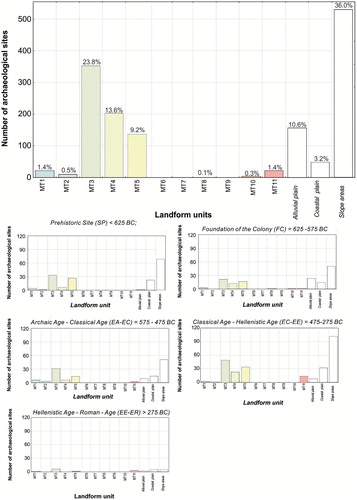
Analysis of the number of archaeological sites for the different chronological periods highlights a progressive increase of settlements and other archaeological elements – sometimes with changes in their function – and a strong increase of human presence during the period of Greek colonization and the Roman period. In fact, a significant increase of sites can be observed in both the coastal plain and in the intermediate orders of marine terraces from classical to Hellenistic time spans. From Hellenistic to Roman times, a dramatic collapse in stable human presence occurred, probably due to historical causes coupled with a landscape deterioration (maybe linked to an increase in flooding occurrence in the coastal plain and in the floodplains of the lower reaches of the main rivers, see CitationGioia et al., 2016 for a fuller discussion). To assess settlement continuity through the entire chronological interval investigated we introduced a simple index, the settlement continuity index (ISC), based on the relationship between the beginning of the settlement age and its abandonment (see the inset ‘Graphs’ in the main map). Highest values of the ISC (=1) indicate a persistence of site occupation from Prehistoric to Roman times, i.e. a settlement continuity through time. About 50% of detected sites have been quickly abandoned. Specifically, the farms and their associated features show low settlement continuity, which implies that they moved forward to more suitable sites or were completely abandoned while sites dedicated to sanctuaries were likely preserved as such through time.
Graphs showing the spatial relationships between archaeological site location and landform units highlight that archaeological sites are preferentially located on mid-altitude marine terraces (mainly MT3, MT4, MT5 marine terraces, see and the inset in the main map). Gentle slope areas and alluvial terraces of the main streams and their main tributaries are other preferential locations for archaeological sites. The frequency distribution of archaeological sites for chronological intervals provided some additional insight into initial territorial occupation and the modification of settlement patterns during the Greek colonization. In fact, we can clearly observe a significant occupation of the coastal plain areas during the initial period of colonization followed by a gradual and significant increase of archaeological sites (mainly farmhouses) on the top of MT3, MT4 and MT5 marine terraces from Archaic to Classical-Hellenistic (EC-EE in ) ages, when human presence increases dramatically. Progressive occupation of marine terraces could suggest a deterioration of the pre-existing environmental setting of the coastal plain and the presence of better conditions for agricultural practices in the marine terrace areas during the Archaic and Hellenistic ages (see Di Leo et al., 2018 for a fuller discussion). Farmhouses in the Metaponto territory indeed increased from 39% of total sites during FC age to 63% during the EA-EC period (about 2520–2420 yr before BP) and, according to literary sources and archaeological research (CitationCarter & Prieto, 2011; CitationDe Siena, 2001), Metaponto was affected by economic growth and a large increase in population from Archaic to Classical ages (CitationDe Siena, 2001). The migration of settlements from low-altitude areas towards marine terraces during the EA-EC period can be related to the spread of agriculture. Moreover, a progressive decrease of settlements in the coastal plain and subsequent increase of sites located in the alluvial terrace areas has been observed from the initial colonization period through to the Hellenistic age, whereas the subsequent stages of Greek colonization and the Roman Age are characterized by a significant decrease of human occupation. This trend of site modification and site abandonment can be related to a deterioration of the landscape (maybe linked to an increase in flooding occurrence in the coastal plain and in the floodplains of the lower reaches of the main rivers, see CitationGioia et al., 2016; CitationPiccarreta et al., 2011 for a fuller discussion) coupled with historical causes. Indeed, the latest stage of Metaponto history is in fact characterized by a significant decrease of human occupation, and the arrival of the Romans in this area marks the final decline of the ancient town and its Chora: Metaponto suffered a significant contraction (only the Castrum area is inhabited) and the territory is progressively depopulated. Finally, archaeological sites located on the top of marine terraces are preferentially distributed near the terrace edges. This preferential distribution could be explained by a preference for good defensive positions or viewpoints.
Figure 3. Frequency distribution of archaeological sites for the different landform units and statistical relationships between of archaeological sites and landform elements for the different chronological intervals.
5. Concluding remarks
The protection and promotion of cultural heritage require the application of innovative and non-invasive monitoring techniques, which can play a crucial role in better understanding the complex interactions between geological, geomorphological and human processes leading to the present distribution and typology of archaeological sites. The map presented here summarizes a huge amount of geological, geomorphological and archaeological data in an area with high ‘archaeological potential’. The wide archive of archaeological data on the whole study area – from Prehistoric times to the Roman age – has been used to connect the transience or persistence of the archaeological sites in relation to different landforms and their changes during the last 5000 years, thus elucidating the settlement patterns and human activities and choices of this coastal area. The layout of the site arrangement clearly traces the main geomorphological features of the area (i.e. settlements along fluvial scarps, sites on the flat surfaces of marine and fluvial terraces, main villages in the coastal plain). Results indicate that an intrinsic geomorphological fragility of the territory has accompanied the strong agricultural vocation of the study area, which persists until the present day.
By unraveling the complex interrelations between geomorphological and anthropological processes responsible for the present archaeological site distribution, the map and its associated geoarchaeological database have allowed a fundamental understanding of the complex human-environment relationships of the study area. This kind of data can be a powerful tool for projects of geo- and archaeo-tourism or educational programs for students, professionals, politicians and heritage managers.
Software
ESRI ArcGIS 9.3 was used to digitize the data collected during the field survey and aerial photo-interpretation and to perform spatial analysis. The DEM was derived from a digital topographic map of the Basilicata region. The final layout of the map was prepared in CORELDRAW X7.
Gioiaetal_Map_Rev_.pdf
Download PDF (8.6 MB)Acknowledgements
The project was funded by PO-FESR granted to Dr. Paola Di Leo. Authors are grateful to two anonymous referees for their accurate revisions.
Disclosure statement
No potential conflict of interest was reported by the authors.
Related Research Data
References
- Adamesteanu, D. (1971). Incoronata. In D. Adamesteanu (Ed.), Popoli anellenici in Basilicata (pp. 18–20). Potenza .
- Adamesteanu, D. (1986). Incoronata – Scavi della Soprintendenza Archeologica della Basilicata (1971-1972). In S. A. D. Basilicata (Ed.), I Greci sul Basento, Mostra degli scavi archeologici all’Incoronata di Metaponto 1971-1984 (pp. 25–27). Como .
- Belluomini, G. , Caldara, M. , Casini, C. , Cerasoli, M. , Manfra, L. , Mastronuzzi, G. , … Vesica, P. L. (2002). The age of Late Pleistocene shorelines and tectonic activity of Taranto area, southern Italy. Quaternary Science Reviews , 21 (4-6), 525–547. doi: 10.1016/S0277-3791(01)00097-X
- Bini, M. , Baroni, C. , & Ribolini, A. (2013). Geoarchaeology as a tool for reconstructing the evolution of the Apuo-Versilian Plain (NW Italy). Geografia Fisica e Dinamica Quaternaria , 36 , 215–224.
- Biscione, M. , Danese, M. , & Masini, N. (2018). A framework for cultural heritage management and research: The Cancellara case study. Journal of Maps , 14 (2), 576–582. doi: 10.1080/17445647.2018.1517699
- Bravi, S. , Fuscaldo, M. D. , Guarino, P. , & Schiattarella, M. (2003). Evoluzione sedimentaria olocenica dell'area dell'antico porto di Cumae (Campi Flegrei). In C. Albore Livadie , & F. Ortolani (Eds.), Variazioni climatico-ambientali e impatto sull’uomo nell’area circum-mediterranea durante l’Olocene (pp. 23–64). Bari, Italy : Edipuglia.
- Brückner, H. (1980). Marine terrassen in Süditalien. Eine quartärmorphologische Studie über das Kustentiefland von Metapont .
- Butzer, K. W. (2008). Challenges for a cross-disciplinary geoarchaeology: The intersection between environmental history and geomorphology. Geomorphology , 101 (1-2), 402–411. doi: 10.1016/j.geomorph.2008.07.007
- Caputo, R. , Bianca, M. , & D’Onofrio, R. (2010). Ionian marine terraces of southern Italy: Insights into the Quaternary tectonic evolution of the area. Tectonics , 29 , doi: 10.1029/2009tc002625
- Carter, J. C. (1990). Dividing the Chora - Metaponto in the 6th-Century-Bc. American Journal of Archaeology , 94 (2), 320–320.
- Carter, J. C. (2003). Metaponto. Gnomon-Kritische Zeitschrift Fur Die Gesamte Klassische Altertumswissenschaft , 75 (8), 715–720.
- Carter, J. C. (2008). La scoperta del territorio rurale Greco di Metaponto . Venosa, Italy : Osanna Edizioni.
- Carter, J. C. , & Prieto, A. (2011). The chora of Metaponto 3. Archaeological field survey Bradano to Basento . Austin : University of Texas.
- Chiartano, B. (1996). La necropoli dell’età del Ferro dell’Incoronata e di San Teodoro (Scavi 1986-1987) (Vol. III). Galatina : Congedo Editore.
- Cilumbriello, A. , Sabato, L. , Tropeano, M. , Gallicchio, S. , Grippa, A. , Maiorano, P. , … Quarta, G. (2010). Sedimentology, stratigraphic architecture and preliminary hydrostratigraphy of the Metaponto coastal-plain subsurface (Southern Italy). Memorie Descrittive Carta Geologica d’Italia , 90 , 67–84.
- Cocco, E. , De Pippo, T. , & Pennetta, M. (1976). L'uso della fotografia aerea e del calcolatore elettronico nello studio degli spostamenti delle linee di costa: l'evoluzione del litorale Alto Ionico (Golfo di Taranto) negli ultimi 30 anni. Bollettino della Società Geologica Italiana , 95 , 275–312.
- Cotecchia, V. , & Magri, G. (1967). Gli spostamenti delle linee di costa quaternarie del mare Ionio fra Capo Spulico e Taranto. Geologia Applicata e Idrogeologia , 4 , 93–148.
- Danese, M. , Gioia, D. , Biscione, M. , & Masini, N. (2014). Spatial methods for archaeological flood risk: The case study of the neolithic sites in the Apulia region (southern Italy) (O. Associacao Portuguesa de Investigacao, U. Kyushu Sangyo, U. Monash, M. Universidade do, B. University of & P. University of, Trans.). In Murgante, B. , Misra, S. , Rocha, A. M. A. C. , Torre, C. M. , Rocha, J. G. , Falcão, M. I. , … Gervasi, O. (Eds.), 14th International Conference on Computational Science and Its Applications, ICCSA 2014 (Vol. 8579 LNCS, pp. 423–439). Guimaraes : Springer Verlag.
- Danese, M. , Masini, N. , Biscione, M. , & Lasaponara, R. (2014). Predictive modeling for preventive archaeology: Overview and case study. Central European Journal of Geosciences , 6 (1), 42–55. doi: 10.2478/s13533-012-0160-5
- De Jaeger, C. , De Dapper, M. , De Vliegher, B. M. , Goossens, R. , Risack, S. , Ozer, A. , … Homes-Fredericq, D. (2000). Geo-archaeological mapping using very high resolution and stereoscopic satellite imagery (Russian TK-350) integrated in a GIS. A case study for the Wadi Mujib area near Lehun (Jordan). Geoarchaeology of the Landscapes of Classical Antiquity , 5 , 7–14.
- De Santis, V. , Caldara, M. , Torres, T. , Ortiz, J. E. , & Sánchez-Palencia, Y. (2018). A review of MIS7 and MIS5 terrace deposits along the Gulf of Taranto based on new stratigraphic and chronological data. Italian Journal of Geosciences , 137 (3), 349–368. doi: 10.3301/IJG.2018.02
- De Siena, A. (1986a). Scavi in località Incoronata ed a Metaponto: nuove scoperte. In I Greci sul Basento (pp. 199–210). Como : Edizioni New Press.
- De Siena, A. (1986b). Termitito e San Vito di Pisticci: dati archeologici e problemi interpretativi Siris-Polieion . In Fonti letterarie e nuova documentazione archeologica (pp. 27–34). Galatina : Siris-Policion.
- De Siena, A. (1999). Il Metapontino: Insediamenti antichi e bonifiche. In Archeologia dell’acqua in Basilicata (pp. 53–72). Lavello, PZ : Sovrintendeza Archeologica della Basilicata, Consiglio Regionale della Basilicata.
- De Siena, A. (2001). Metaponto. Archeologia di una colonia greca . Taranto : Scorpione Editore.
- Di Leo, P. , Bavusi, M. , Corrado, G. , Danese, M. , Giammatteo, T. , Gioia, D. , & Schiattarella, M. (2018). Ancient settlement dynamics and predictive archaeological models for the Metapontum coastal area in Basilicata, southern Italy: From geomorphological survey to spatial analysis. Journal of Coastal Conservation , 22 (5), 865–877. doi: 10.1007/s11852-017-0548-y
- Giardino, L. (1991). Grumentum e Metaponto. Due esempi di passaggio dal tardoantico all'alto medioevo in Basilicata. Mélanges de l'École française de Rome . Moyen-Age, tome, 103 (2), 827–858.
- Gioia, D. , Bavusi, M. , Di Leo, P. , Giammatteo, T. , & Schiattarella, M. (2016). A geoarchaeological study of the Metaponto coastal belt, southern Italy, based on geomorphological mapping and GIS-supported classification of landforms. Geografia Fisica e Dinamica Quaternaria , 39 , 137–148. doi:10.4461/ GFDQ 2016.39.13
- Gioia, D. , Del Lungo, S. , Sannazzaro, A. , & Lazzari, M. (2019). Geological and geomorphological controls on the path of an intermountain Roman road: The case of the via Herculia, Southern Italy. Geosciences , 9 (9), 398.
- Gioia, D. , Schiattarella, M. , & Giano, S. (2018). Right-angle pattern of minor fluvial networks from the ionian terraced belt, Southern Italy: Passive structural control or foreland bending? Geosciences , 8 (9), 331.
- Grippa, A. , Bianca, M. , Tropeano, M. , Cilumbriello, A. , Gallipoli, M. R. , Mucciarelli, M. , & Sabato, L. (2011). Use of the HVSR method to detect buried paleomorphologies (filled incised-valleys) below a coastal plain: The case of the Metaponto plain (Basilicata, southern Italy). Bollettino Di Geofisica Teorica Ed Applicata , 52 (2), 225–240. doi: 10.4430/Bgta0011
- Lazzari, M. , Gioia, D. , & Anzidei, B. (2018). Landslide inventory of the Basilicata region (Southern Italy). Journal of Maps , 14 (2), 348–356. doi: 10.1080/17445647.2018.1475309
- Lisiecki, L. E. , & Raymo, M. E. (2005). A Pliocene-Pleistocene stack of 57 globally distributed benthic δ18O records. Paleoceanography , 20 (1). doi:10.1029/2004pa001071
- Pescatore, T. , Pieri, P. , Sabato, L. , Senatore, M. R. , Gallicchio, S. , Boscaino, M. , … Capretto, G. (2009). Stratigrafia dei depositi pleistocenico-olocenici dell'area costiera di Metaponto compresa fra Marina di Ginosa ed il Torrente Cavone (Italia meridionale): Carta Geologica in scala 1:25.000. Il Quaternario , 22 , 307–324.
- Piccarreta, M. , Caldara, M. , Capolongo, D. , & Boenzi, F. (2011). Holocene geomorphic activity related to climatic change and human impact in Basilicata, Southern Italy. Geomorphology , 128 (3-4), 137–147. doi: 10.1016/j.geomorph.2010.12.029
- Putignano, M. L. , Orrù, P. E. , & Schiattarella, M. (2014). Holocene coastline evolution of Procida Island, Bay of Naples, Italy. Quaternary International , 332 , 115–125. doi: 10.1016/j.quaint.2014.03.003
- Sabato, L. , Longhitano, S. G. , Gioia, D. , Cilumbriello, A. , & Spalluto, L. (2012). Sedimentological and morpho-evolution maps of the ‘Bosco Pantano di Policoro’ coastal system (Gulf of Taranto, southern Italy). Journal of Maps , 8 (3), 304–311. doi: 10.1080/17445647.2012.722791
- Salvador, A. (1994). International stratigraphic guide: A guide to stratigraphic classification, terminology, and procedure . Boulder: Geological Society of America.
- Sauer, D. , Wagner, S. , Bruckner, H. , Scarciglia, F. , Mastronuzzi, G. , & Stahr, K. (2010). Soil development on marine terraces near Metaponto (Gulf of Taranto, southern Italy). Quaternary International , 222 (1-2), 48–63. doi: 10.1016/j.quaint.2009.09.030
- Schiattarella, M. , Giano, S. I. , & Guarino, P. (1998). Interazione uomo-ambiente e sistemi geoarcheologici. In C. Albore Livadie , & F. Ortolani (Eds.), Il Sistema Uomo-Ambiente tra Passato e Presente (Vol. 19981, pp. 181–184). Bari, Italy : Edipuglia.
- Schmaltz, E. , Märker, M. , Rosner, H.-J. , & Kandel, A. W. (2014). The integration of landscape processes in archaeological site prediction in the Mugello basin (Tuscany/Italy). In F. Giligny , F. Djindjian , L. Costa , P. Moscati , & S. Robert (Eds.), Proceedings of the 42nd annual conference on computer applications and quantitative methods in archaeology, CAA 2014 (pp. 451–458).
- Shackleton, N. J. (1987). Oxygen isotopes, ice volume and sea level. Quaternary Science Reviews , 6 (3), 183–190. doi:10.1016/0277-3791(87)90003-5
- Silbernagel, J. , Martin, S. R. , Gale, M. R. , & Chen, J. Q. (1997). Prehistoric, historic, and present settlement patterns related to ecological hierarchy in the eastern upper Peninsula of Michigan, USA. Landscape Ecology , 12 (4), 223–240. doi: 10.1023/A:1007946907682
- Tropeano, M. , Cilumbriello, A. , Sabato, L. , Gallicchio, S. , Grippa, A. , Longhitano, S. G. , … Spilotro, G. (2013). Surface and subsurface of the Metaponto Coastal Plain (Gulf of Taranto-southern Italy): Present-day- vs LGM-landscape. Geomorphology , 203 , 115–131. doi: 10.1016/j.geomorph.2013.07.017
- Tropeano, M. , Sabato, L. , & Pieri, P. (2002). Filling and cannibalization of a foredeep: The Bradanic Trough, Southern Italy. Sediment Flux to Basins: Causes, Control and Consequences , 191 , 55–79. doi: 10.1144/Gsl.Sp.2002.191.01.05
- Turrero, P. , Dominguez-Cuesta, M. J. , Jimenez-Sanchez, M. , & Garcia-Vazquez, E. (2013). The spatial distribution of Palaeolithic human settlements and its influence on palaeoecological studies: A case from Northern Iberia. Journal of Archaeological Science , 40 (12), 4127–4138. doi: 10.1016/j.jas.2013.06.003
- Vaughn, S. , & Crawford, T. (2009). A predictive model of archaeological potential: An example from northwestern Belize. Applied Geography , 29 (4), 542–555. doi: 10.1016/j.apgeog.2009.01.001
- Verhagen, P. , & Dragut, L. (2012). Object-based landform delineation and classification from DEMs for archaeological predictive mapping. Journal of Archaeological Science , 39 (3), 698–703. doi: 10.1016/j.jas.2011.11.001
- Vezzani, L. (1967). I depositi plio-pleistocenici del litorale ionico della Lucania. Atti Accademia Gioenia Scienze Naturali Catania , 18 , 159–180.
- Warren, R. E. , & Asch, D. L. (2000). A predictive model of archaeological site location in the eastern prairie peninsula. In K. L. Westcott , & R. J. Brandon (Eds.), Practical applications of GIS for archaeologists: A predictive modeling toolkit (pp. 5–32). London : Taylor and Francis.
- Westaway, R. , & Bridgland, D. (2007). Late Cenozoic uplift of southern Italy deduced from fluvial and marine sediments: Coupling between surface processes and lower-crustal flow. Quaternary International , 175 , 86–124. doi: 10.1016/j.quaint.2006.11.015
- Zander, A. , Fulling, A. , Bruckner, H. , & Mastronuzzi, G. (2006). OSL dating of Upper Pleistocene littoral sediments: A contribution to the chronostratigraphy of raised marine terraces bordering the Gulf of Taranto. South Italy. Geografia Fisica e Dinamica Quaternaria , 29 (1), 33–50. doi: 10.3301/rol.2011.54