
ABSTRACT
The Neoacadian Burnsville fault is a dextral transpressional structure exposed in western North Carolina. Bedrock geologic mapping in the Clyde 7.5-minute quadrangle documents the fault an additional ∼40 km southwest than previously mapped. Here it overprints the contact between the Ashe Metamorphic Suite (AMS) and Grenville basement and a portion of the Hayesville fault, both older Taconic structures. Neoacadian deformation was partitioned onto these pre-existing structures. The Burnsville fault intersects faults previously interpreted as the younger Alleghanian Fries and Chattahoochee faults. These do not offset the Burnsville fault here suggesting that they are Taconic and not the Fries and Chattahoochee faults. Our results suggest: (1) Grenville basement was thrust over the Cartoogechaye terrane, (2) the AMS was thrust over both by the Holland Mountain thrust, (3) all were then thrust over the Great Smoky Group by the Hayesville fault, and (4) these structures were later overprinted by Neoacadian dextral shear.
1. Introduction
The Appalachian Mountains, located in the eastern United States, record a multi-stage tectonic history associated with the assembly of Pangaea following the ∼1 Ga Grenville aged assembly and subsequent rifting of the supercontinent Rodinia. The assembly of Pangea involved three major orogenic events: the Ordovician Taconic, Silurian-Devonian Acadian (Neoacadian in the southern Appalachians), and late Paleozoic Alleghanian orogenies (e.g. CitationDrake et al., 1989; CitationGoldberg et al., 1989; CitationHatcher, 1989). The Taconic and Acadian-Neoacadian orogenies resulted in metamorphism, folding, faulting, and intrusion of igneous rock. Whereas these two orogenic events can be readily distinguished in the northern Appalachians (e.g. CitationArmstrong et al., 1992; CitationStanley & Ratcliffe, 1985), the kinematics and metamorphism associated with the Taconic and Neoacadian orogenies in the southern Appalachians are difficult to differentiate due to similar metamorphic conditions and overprinting of structures. To further complicate things, both of these events are overprinted by deformation that occurred during the later Paleozoic Alleghanian orogeny.
Aside from studies of the Burnsville fault, previous studies have concentrated on discriminating the Neoacadian event in the southeastern United States through combined kinematic and geologic mapping, geochronology, and petrologic analyses. Examples include amphibolite grade metamorphism at ∼352 Ma (e.g. CitationCarrigan et al., 2003), northeast-southwest trending mineral stretching lineations in the inner Piedmont associated with orogen-parallel escape tectonics (e.g. CitationMerschat et al., 2005), and plutonism (e.g. CitationMiller et al., 2000) at the time of the Neoacadian orogeny. Regardless, a geologic record of this event in the Blue Ridge Mountains () of western North Carolina is limited.
Figure 1. Simplified geologic map of a portion of the Blue Ridge Mountains (BRM) in western North Carolina, south of the Grandfather Mountain Window (GMW). The box is the Clyde 7.5-minute quadrangle. HMT, Holland Mountain thrust fault. From CitationStewart et al. (1997), modified to include the Asheville and Waynesville areas from CitationBream (2003); CitationHatcher et al. (2004); CitationMerschat and Cattanach (2008). Structures within the basement rocks have been simplified but include the Unaka-Linville Falls, Fork Ridge, Sams Gap-Pigeonroost, and Fries thrust sheets. Inset shows the geographic position of the geologic map on a digital elevation model of North Carolina where light colours represent higher elevations.
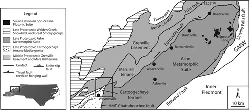
The Burnsville fault in western North Carolina is the only structure documented in the Blue Ridge to record Neoacadian deformation and thus has provided a unique opportunity to evaluate the kinematics and crustal evolution that resulted from this event (CitationAdams et al., 1995a, Citation1995b; CitationAdams & Trupe, 1997; CitationCowan & Trupe, 2001; CitationLangille et al., 2018; CitationTrupe et al., 2003; CitationWaters-Tormey & Stewart, 2010). The shear zone defines the contact between the Ashe Metamorphic Suite (AMS) and Grenville basement for ∼80 km along strike between Weaverville and Bakersville, NC (). CitationAdams et al. (1995a, Citation1995b) and CitationLevine et al. (2018) suggest that the northward continuation of the Burnsville fault may be the Gossan-Lead fault north of the Grandfather Mountain Window. The southward extension of the fault is unclear. CitationTrupe et al. (2003) suggests that the Burnsville fault either continues south overprinting the Taconic Hayesville fault or is truncated by the younger Alleghanian Fries-Chattahoochee thrust faults (). The result is an unclear interpretation of the spatial and temporal relationship between these faults.
The contact between the AMS and Grenville basement is exposed in the Clyde 7.5-minute quadrangle. This quadrangle also includes what has been interpreted as the Taconic Hayesville thrust fault and the Alleghanian Fries and Chattahoochee thrust faults () making this an ideal locality to (1) test models that either the Burnsville fault continues south into this quadrangle and overprints the Hayesville fault or is truncated by the Fries-Chattahoochee thrust faults and (2) determine the spatial and temporal relationship between the Burnsville fault and the other structures exposed within this quadrangle.
2. Faults within the quadrangle
The AMS was initially emplaced over the Grenville basement as an accretionary wedge during northwest-directed thrusting during the Taconic orogeny when the Piedmont terrane collided with Laurentia () (e.g. CitationHatcher, 1989; CitationHorton et al., 1989; CitationMerschat et al., 2017). This contact was originally interpreted as a Taconic structure called the Holland Mountain thrust fault (e.g. CitationMerschat, 1993; CitationMerschat & Wiener, 1988). Subhorizontal, northeast-trending mineral stretching lineations inconsistent with northwest-directed thrusting during the Taconic was noted along this contact near Burnsville, NC () by CitationAdams et al. (1995a). This led them to conclude that this Taconic suture was overprinted by dextral faulting and called it the Burnsville fault. Ages of deformed leucogranite from the shear zone near Burnsville combined with hornblende 40Ar/39Ar cooling ages suggest the shear zone was active between ∼362 and 377 Ma toward the end of the Neoacadian orogeny (CitationGoldberg & Dallmeyer, 1997; CitationTrupe et al., 2003). CitationTrupe et al. (2003) suggested that the AMS and Grenville basement contact may not reflect a Taconic suture (the Holland Mountain thrust fault), rather this contact was emplaced by large-scale dextral motion on the Burnsville fault.
CitationTrupe et al. (2003) mapped the Burnsville fault near Burnsville, NC as a moderate to steeply dipping mylonite zone that strikes northeast-southwest with a gently plunging stretching lineation. They suggest that the dip of the shear zone was steep at the time of shearing and had not been rotated significantly during Alleghanian thrusting. They document tails on porphyroclasts, mica fish, and shear bands that indicate a dextral shear sense. In addition, CitationTrupe et al. (2003) suggest that Taconic folds in the vicinity of the shear zone near Burnsville, NC show dextral rotation. Microstructural indicators in this portion of the shear zone suggest deformation temperatures of >500°C. Detailed mapping and structural analysis of foliations, stretching lineations, and folds in the Bakersville area () by CitationWaters-Tormey and Stewart (2010) suggests that the Burnsville fault in this portion of the system records wrench-dominated transpression with rotation consistent with dextral shearing.
This shear zone near Weaverville, North Carolina, is a ∼2.5 km wide near vertical transpressional dextral shear zone composed of mylonitic and ultramylonitic gneiss, schist, and amphibolite that were deformed under amphibolite facies conditions () (CitationCowan & Trupe, 2001; CitationLangille et al., 2018; CitationTrupe et al., 2003). Similar to exposures toward the north, here the shear zone is defined by a zone of near-vertical dipping mylonite with consistent shallowly plunging mineral stretching lineations that trend northeast-southwest (CitationLangille et al., 2018). As the only Neoacadian structure yet to be identified in the Blue Ridge, these previous studies of the Burnsville fault are significant in that they document that the Neoacadian event did produce deformation in the Blue Ridge Mountains and that it was dominated by transpression.
The Hayesville fault is a Taconic aged structure that records northwest-directed thrusting that predates the Burnsville fault (CitationMassey & Moecher, 2005; CitationMoecher et al., 2018). In our study area, it separates the Cartoogechaye terrane from the Great Smoky and Snowbird groups (). The rocks along this contact southwest of our study area record high-grade metamorphism, with melting and partial melting in rocks on both sides of this fault. Deformation associated with the Taconic here has largely been overprinted by multiple metamorphic and folding events (CitationMassey & Moecher, 2005; CitationMoecher et al., 2018).
The Fries and Chattahoochee faults are Alleghanian aged structures. The Chattahoochee fault truncates the Rabun granite south of the map in . The granite has been dated at 335 Ma (CitationMiller & Stewart, 2002) which led to an understanding that this is an Alleghanian structure. This fault has been interpreted to continue along the AMS and Grenville basement contact from southern North Carolina south into Georgia, potentially overprinting the Holland Mountain thrust fault () (e.g. CitationHatcher et al., 2005; CitationMiller et al., 2006). The Fries fault to the northeast of the Clyde quadrangle, closer to the Grandfather Mountain Window (), contains shear sense indicators associated with northwest-directed thrusting (CitationTrupe et al., 2004). The Spruce Pine pegmatites (∼335 Ma) are sheared by the Fries fault. Combined with constraints on the metamorphic conditions at the time of deformation, this fault was active during greenschist-facies metamorphic conditions during the Alleghanian orogeny (CitationTrupe et al., 2004).
3. Map construction
Geological mapping was performed at 1:24,000 scale. Field mapping of rock units and structural measurements were collected over the summer of 2018. Initial mapping targeted outcrops along roads. Outcrops on private property identified from roads and from 2018 Landsat L8 satellite imagery were mapped upon permission of the land owner. GPS locations (WGS84-UTM) were logged for all outcrops where a rock unit was recorded or structural measurements were taken. Typical horizontal accuracies for our GPS unit is ∼3–5 m. The geology was overlain on the 2013 USGS topographic base map. A cross-section was drawn perpendicular to the dominant foliation strike.
4. Rock unit descriptions
The rock units within this quadrangle were originally mapped by CitationMerschat and Wiener (2006). The Copper Hill Formation was initially described by CitationHadley and Goldsmith (1963). Our observations and mapping efforts build off their work (refer to Main Map). With the exception of relocating the placement of some geologic contacts, our mapping of rock units are consistent with these previous mapping efforts.
4.1. Copper hill formation
The late Proterozoic Copper Hill Formation (undifferentiated, Zchu) is composed of garnet-mica schist, kyanite-garnet-mica schist, and metagraywacke that is part of the Great Smoky Group. The metagraywacke is grey, coarse- to medium-grained, and generally massive. The metagraywacke is interlayered with the mica schists. These units are dominated by muscovite (>60%), are strongly foliated, coarse grained, and contain porphyroblasts of garnet and kyanite.
4.2. Ashe metamorphic suite
The late Proterozoic AMS in this quadrangle includes biotite gneiss with metagraywacke (Zamb) and aluminous schist (Zas). Biotite gneiss of Zamb is light to dark grey, migmatitic, foliated, and medium- to coarse-grained, dominated by quartz, feldspar, and biotite. The metagraywacke is generally massive or weakly foliated and has rare interlayers of amphibolite. Zas is more aluminous and dominated by muscovite. This unit is light-grey to greenish-grey, strongly foliated, and medium-grained with abundant porphyroblasts of garnet. Sillimanite, kyanite, and quartz are also present. Zas is locally interlayered with metagraywacke, gneiss, and minor amphibolites.
4.3. Cartoogechaye terrane
The main units included in the late Proterozoic Cartoogechaye terrane are felsic and biotite gneiss (ZYc), metagraywacke (ZYcg), and migmatite (ZYcm). ZYc includes interlayered biotite granitic gneiss and quartz diorite gneiss with lenses of amphibolite. The gneiss is medium- to coarse-grained, well foliated with coarse biotite. The amphibolite is massive, coarse-grained, and dark grey to black. The metagraywacke (ZYcg) is a massive, light to medium grey complex commonly interlayered with Zyc that is composed of mainly quartz, feldspar, and biotite. Migmatite (ZYcm) was seen throughout the terrane as highly deformed bodies that were derived from high grade metamorphism and partial melting. This unit is foliated and dominated by biotite quartz, and feldspar.
4.4. Sandymush Formation
The middle Proterozoic Sandymush Formation is composed of felsic gneiss (Ys) and amphibolite (Ysa) that are the oldest rocks in this quadrangle. These are part of the Grenville basement complex. Ys is a grey, well foliated gneissic to granitic unit dominated by quartz, biotite, and feldspar interlayered with biotite schist and amphibolite. Ysa is a dark green, well foliated, fine- to coarse-grained amphibolite unit interlayered with Ys.
5. Structural observations
5.1. Burnsville fault
Our most significant additions to the pre-existing bedrock geologic map of this quadrangle (CitationMerschat & Wiener, 2006) includes recognition of the Burnsville fault and reevaluation of the direction of movement on the faults. The Burnsville fault in this quadrangle was not originally mapped and described by CitationMerschat and Wiener (2006). It overprints multiple lithologies relating to multiple lithostratigraphic units. The northeast portion of this fault within the quadrangle overprints the contact between the AMS and the Sandymush Formation. Toward the southwest the shear zone overprints a portion of the Cartoogechaye terrane and muscovite schist that was mapped by CitationMerschat and Wiener (2006) as the Copper Hill Formation.
The Burnsville fault here is defined by ultramylonite to mylonite that has consistent, well defined mineral stretching lineations that trend northeast or southwest, parallel to strike with shallow to horizontal plunges. The foliation dominantly strikes northeast to southwest, ∼N45°E, with near-vertical dips (refer to the Main Map for stereonets of all structural measurements).
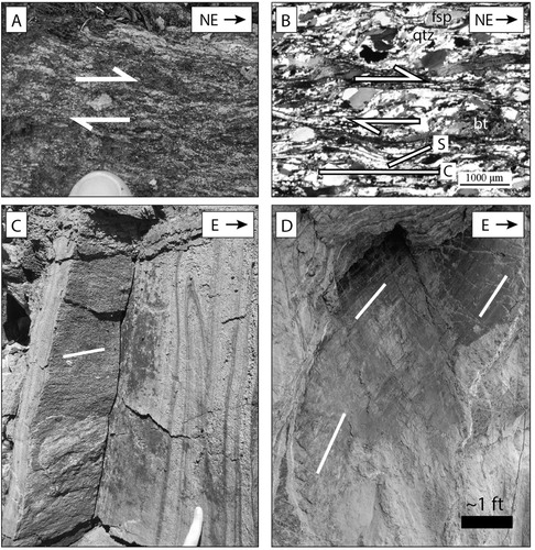
Mapping was extended east into the Canton 7.5-minute quadrangle (CitationMerschat & Wiener, 1988) where the Burnsville fault is well exposed to characterize the fault in this portion of the quadrangle. Here the foliation is also vertical, strikes northeast to southwest, has shallow to horizontal plunging mineral stretching lineations, and is in line with the strike of the Burnsville mylonite on the west side of the quadrangle, supporting a consistent dextral zone across this quadrangle. The stretching lineations throughout were defined by elongated quartz and feldspar (A, B, C). Extensive shear sense indicators including tails on rotated porphyroclasts, S–C fabrics, and mica fish support dextral shearing (A, B). Folds with compression perpendicular to foliation suggest transpression (C). In one locality, spectacularly preserved fault striations overprint these ductile fabrics, recording a brittle history following cessation of ductile deformation (D).
Figure 2. Deformation within the Burnsville fault. (A) Tails on feldspar porphyroclast indicate dextral shearing. Viewed looking down, perpendicular to foliation and parallel to the stretching lineation. (B) Photomicrograph of a thin section with asymmetric quartz and feldspar along with S-C fabrics that also indicate dextral shear. View is the same orientation as A. qtz, quartz; fsp, feldspar; bt, biotite. (C) Shallow stretching lineations highlighted in white and folds suggesting transpression. (D) Fault striations (white lines) record brittle deformation, post-dating ductile deformation and not associated with the Burnsville fault.
5.2. North and South of the Burnsville fault
The Cartoogechaye terrane is separated from the Copper Hill Formation in the northwest corner of the quadrangle by the Hayesville thrust fault (defined by CitationMerschat & Wiener, 2006). The Copper Hill Formation dominantly strikes northeast-southwest with variable dip amounts. Mineral lineations in this formation trend northeast or southwest with plunge magnitudes ranging from 15° to 31°, steeper than noted within the Burnsville fault mylonite.
In the northeastern section of the quadrangle, the Sandymush Formation is thrust over the Cartoogechaye terrane along what was previously assumed to be the Fries thrust fault. This fault contact here has a well-developed mylonite that has strong mineral stretching lineations that plunge ∼50° east defined by elongated quartz and feldspar (A), notably steeper than lineations within the Burnsville fault. Shear sense indicators such as tails on feldspar porphyroclasts and shear folds (B and C) indicate west-directed thrusting, distinctly different than the shear sense documented within the Burnsville fault.
Figure 3. (A) Down-dip stretching lineations highlighted in white, (B) tails on feldspar porphyroclasts, and (C) shear fold at the contact between the Cartoogechaye terrane (ZYc) and the Sandymush Formation (Ys) that indicate top-west thrusting. (D) Sheath folds showing northwest directed thrusting within the migmatite unit of the Cartoogechaye terrane (ZYcm).
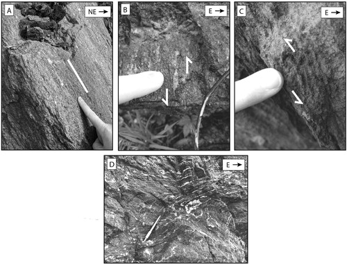
Cartoogechaye terrane rocks exposed between the Great Smoky Group in the northwest portion of the quadrangle and the Burnsville are extensively folded with variable strike and dip but dominantly strike northeast-southwest. Mineral lineations are variable but generally trend northeast or southwest with plunge magnitudes ranging from 6° to 86°. West-directed thrust shear sense defined by tails on porphyroclasts, shear folds, and sheath folds were observed throughout the Cartoogechaye terrane (D), although they are less mylonitic than within the faults. These rocks do not exhibit evidence of bring overprinted by strike-slip deformation of the Burnsville fault.
The AMS structurally overlies the Cartoogechaye terrane south of Burnsville fault. The rocks on both side of this contact dominantly strike northeast-southwest with mineral lineations that also dominantly trend northeast or southwest with variable plunge. Unlike the Burnsville fault and the fault between the Sandymush Formation and the Cartoogechaye terrane to the north, there were no noted mylonites along the contact between the AMS and Cartoogechaye terrane, which had previously been assumed to correlate to the Chattahoochee thrust fault ().
6. Key findings and implications
-
The northeast-southwest striking dextral Burnsville fault extends another ∼40 km southwest into the Clyde 7.5-minute quadrangle from where it has been previously mapped between Burnsville and Weaverville, North Carolina (CitationCowan & Trupe, 2001; CitationLangille et al., 2018). The location of the Burnsville fault in the Clyde quadrangle is in line with the strike of the fault near Weaverville and Burnsville (). Furthermore, exposures here have comparable foliation and lineation orientations (refer to the Main Map), supporting this interpretation.
-
The fault overprints the contact between the AMS and the Grenville basement complex as well as a portion of the Great Smoky Group (Zchu) that was initially emplaced by the Taconic Hayesville fault (CitationMerschat & Wiener, 2006). CitationTrupe et al. (2003) suggest that the AMS contact with Grenville basement was emplaced by large-scale dextral motion on the Burnsville fault and may not reflect Taconic emplacement. The contact between the AMS and Grenville basement is exposed south of the Burnsville fault in the Clyde quadrangle, where it does not record dextral transpression (). This supports an interpretation that this contact was emplaced prior to deformation along the Burnsville fault during the Taconic and a portion was later overprinted by Neoacadian dextral shear.
-
Neoacadian deformation took advantage of pre-existing structures and contacts as dextral transpression was partitioned into the Blue Ridge. During this time, shear zone development was localized along the contact between the AMS and Grenville basement between Burnsville and Weaverville, North Carolina (CitationCowan & Trupe, 2001; CitationLangille et al., 2018; CitationTrupe et al., 2003), likely because this is a rheological heterogeneity. Deformation along the Burnsville fault occurred along this contact south into the Clyde quadrangle where it continued through the rheologically weak muscovite schist of the Great Smoky Group within a folded portion of the Hayesville fault (CitationMerschat & Wiener, 2006). We suggest that the Burnsville fault continued south along the Hayesville fault in this quadrangle and not south along the boundary of the AMS because it was able to take advantage of the rheologically weak Copper Hill Formation of the Great Smoky Group (Zchu).
-
The north–south striking thrust faults that were previously assumed to correlate to the Fries and Chattahoochee faults, which intersect the Burnsville fault to the north and south in the Clyde quadrangle, do not offset the Burnsville fault. The Neoacadian age of the Burnsville fault (CitationGoldberg & Dallmeyer, 1997; CitationTrupe et al., 2003) demonstrates that these are likely older Taconic structures and not Alleghanian as previously interpreted. Thus, they are not the younger Alleghanian Fries or Chattahoochee thrust faults ( and ). The Fries and Chattahoochee faults must outcrop elsewhere and not in this quadrangle.
A question that results from these findings is where the Fries and Chattahoochee faults go if not into the Clyde quadrangle? Additional studies beyond this quadrangle are needed to constrain this.
-
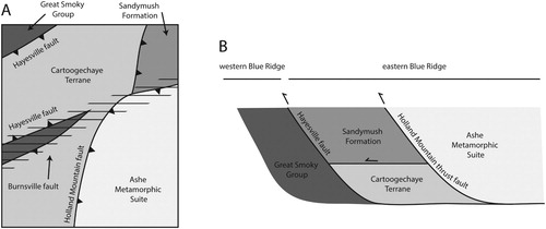
As stated before, the AMS is documented in contact with the Grenville basement between Weaverville and Burnsville (CitationCowan & Trupe, 2001; CitationTrupe et al., 2003). In the Clyde quadrangle, the AMS is thrust over the Grenville basement and the Cartoogechaye terrane. Additionally, shear sense indicators support the interpretation that here the Grenville basement (Sandymush Formation) was thrust over the Cartoogechaye terrane (). These observations suggest the following temporal model for the faults in this quadrangle: During the Taconic orogeny, Grenville basement was thrust over the Cartoogechaye terrane, the AMS was thrust over both of those along the Holland Mountain thrust fault, and this entire complex was then thrust over the Great Smoky Group along the Hayesville fault. This was later overprinted by Neoacadian dextral shear along the Burnsville fault ().
-
While the portion of the Hayesville fault exposed here is overprinted by Neoacadian dextral transpression, CitationMassey and Moecher (2005) provide detailed field mapping and kinematic observations from the Hayesville fault ∼10 km to the southwest that does not suggest any overprinting by Neoacadian dextral shear. Thus, the Burnsville fault either continues elsewhere toward the southwest, is truncated by a younger structure between here and there, or tapers out. Additional studies beyond this quadrangle could test these models. These findings support a model from CitationTrupe et al. (2003) that the Burnsville fault continues south and overprints a portion of the Hayesville fault. Although, we cannot exclude their other model that the Burnsville fault is truncated by the Fries-Chattahoochee thrust fault system. It is possible that it is truncated by these faults southwest of the Clyde quadrangle.
Figure 4. (A) Simplified geologic map of the Clyde 7.5-minute quadrangle with faults and direction of motion interpreted from this study. Triangles are on the hanging wall side of the thrust faults. The dextral Burnsville fault is symbolized with lines where it has overprinted the older structures. Refer to the Main Map for the detailed geologic map. (B) Schematic tectonic interpretation of fault bounded terranes based on data and observations from this study. We interpret that all of these structures were emplaced during the Taconic orogeny and later overprinted by the Burnsville fault.
7. Conclusions
The new 1:24,000 scale bedrock geologic mapping and kinematic analysis presented here provides new constraints on the temporal evolution of Taconic and Neoacadian structures in the southern Appalachians of western North Carolina. Neoacadian deformation was localized along the Burnsville fault within western North Carolina and extended for at least ∼120 km along strike from Burnsville to Clyde, North Carolina. Neoacadian deformation in the Blue Ridge was partitioned onto pre-existing structures that were emplaced during the Taconic orogeny. Recognition of the dextral Burnsville fault overprinting the Hayesville fault in this quadrangle combined with other studies that suggest it does not overprint the Hayesville fault ∼10 km to the southwest suggests that the Burnsville fault either continues elsewhere toward the southwest, is truncated by a younger structure between here and there, or tapers out.
Software
Field mapping of rock units and structural measurements were collected digitally with an iPad equipped with FieldMove software from Midland Valley. Landsat L8 2018 satellite imagery was utilized to supplement the identification of outcrops. ArcGIS 10.6 was utilized to view the satellite imagery. All field data were exported to ArcGIS Desktop 10.6 for map compilation. The geology was exported to Adobe Illustrator and overlain on the 2013 USGS topographic base map. The final version of the bedrock map was delivered to the USGS in Portable Document Format (PDF).
Geolocation information
The Clyde 7.5-minute quadrangle is bound between the following coordinates: 35° 37′ 30″, −83° 00′ and 35° 30′, −82° 52′ 30″.
Clyde_Geo_Map.pdf
Download PDF (26.5 MB)Acknowledgements
We appreciate reviews by Dr. Jamie Levine, Dr. Arthur Merschat, John Abraham, and editorial feedback from Dr. Mike Smith. Their feedback strengthened this manuscript and map. Haley Deese and Adam Ornelles provided field support. We thank Bart Cattanach from the North Carolina Geological Survey (NCGS) for his time in the field with us and discussions that strengthened this study. Thanks also to Dr. Kenneth Taylor from the NCGS for his support of this project. This manuscript is submitted for publication with the understanding that the United States Government is authorized to reproduce and distribute reprints for governmental use. Supported by the U.S. Geological Survey, EDMAP Program, under assistance Award No. G18AC00099 and from the University of North Carolina at Asheville. The views and conclusions contained in this document are those of the authors and should not be interpreted as necessarily representing the official policies, either expressed or implied, of the U.S. Government.
Disclosure statement
No potential conflict of interest was reported by the author(s).
Additional information
Funding
References
- Adams, M. , Stewart, K. , Trupe, C. , & Willard, R. (1995a). Tectonic significance of high-pressure metamorphic rocks and dextral strike-slip faulting along the Taconic suture. In J. Hibbard , C. van Staal , & P. Cawood (Eds.), Current perspectives in the Appalachian-Caledonian orogeny (Vol. 41, pp. 21–42). Geological Association of Canada, Special Paper.
- Adams, M. , & Trupe, C. (1997). Conditions and timing of metamorphism in the Blue Ridge thrust complex, northwest North Carolina and eastern Tennessee. In K. Stewart , M. Adams , & C. Trupe (Eds.), Paleozoic structure, metamorphism, and tectonics of the Blue Ridge of western North Carolina (pp. 33–47). Carolina Geological Society Fieldtrip Guidebook.
- Adams, M. , Trupe, C. , Goldberg, S. , Stewart, K. , & Butler, J. (1995b). Pressure-temperature history of high-grade metamorphic rocks along the eastern-western Blue Ridge boundary, northwestern North Carolina. Geological Society of America Abstracts with Programs , 27 , 33.
- Armstrong, T. , Tracy, R. , & Hames, W. (1992). Contrasting styles of Taconian, eastern Acadian and western Acadian metamorphism, central and western New England. Journal of Metamorphic Geology , 10 (3), 415–426. https://doi.org/10.1111/j.1525-1314.1992.tb00093.x
- Bream, B. R. (2003). Tectonic implications of geochronology and geochemistry of para- and orthogneisses from the southern Appalachian crystalline core [Doctoral dissertation]. Knoxville, University of Tennessee, 296 p.
- Carrigan, C. , Miller, C. , Fullagar, P. , Bream, B. , Hatcher Jr., R. , & Coath, C. D. (2003). Ion microprobe age and geochemistry of southern Appalachian basement, with implications for Proterozoic and Paleozoic reconstructions. Precambrian Research , 120 (1-2), 1–36. https://doi.org/10.1016/S0301-9268(02)00113-4
- Cowan, C. , & Trupe, C. (2001). Structural and kinematic analysis of the eastern-western Blue Ridge contact in the Weaverville quadrangle, western North Carolina. Geological Society of America Abstracts with Programs , 33 , 232.
- Drake, A. A. Jr. , Sinha, A. K. , Laird, J. , & Guy, R. E. (1989). The Taconic orogen, in the Appalachian-Ouachita orogen in the United States. In R. D. Hatcher Jr. , W. Thomas , & G. Viele (Eds.), The Appalachian-Ouachita orogen in the Unites States (pp. 101–178). Geological Society of America.
- Goldberg, S. A. , Butler, J. R. , Mies, J. W. , & Trupe, C. H. (1989). The southern Appalachian Orogen in northwestern North Carolina and adjacent states. IGC Field Trip T365, University of North Carolina at Chapel Hill, p. 1–55.
- Goldberg, S. , & Dallmeyer, R. (1997). Chronology of Paleozoic metamorphism and deformation in the Blue Ridge thrust complex, North Carolina and Tennessee. American Journal of Science , 297 (5), 488–526. https://doi.org/10.2475/ajs.297.5.488
- Hadley, J. , & Goldsmith, R. (1963). Geology of the eastern Great Smoky Mountains North Carolina and Tennessee. U.S. Geological Survey Professional Paper , 349–B , 1–114.
- Hatcher, R. D. Jr. (1989). Tectonic synthesis of the U.S. Appalachians, in the Appalachian-Ouachita orogen in the United States. In R. D. Hatcher Jr. , W. Thomas , & G. Viele (Eds.), The Appalachian-Ouachita orogen in the Unites States (pp. 233–318). Geological Society of America.
- Hatcher, R. D. Jr. , Bream, B. R. , Miller, C. L. , Eckert, J. O. Jr. , Fullagar, P. D. , & Carrigan, C. W. (2004). Paleozoic structure of internal basement massifs, southern Appalachian Blue Ridge, incorporating new geochronologic, Nd and Sr isotopic, and geochemical data. In R. P. Tollo , L. Corriveau , J. McLelland , & M. J. Bartholomew (Eds.), Proterozoic tectonic evolution of the Grenville orogen in North America (Vol. 197, pp. 525–547). Geological Society of America Memoir.
- Hatcher, R. D. Jr. , Merschat, A. J. , & Thigpen, J. R. (2005). Blue Ridge primer. In R. D. Hatcher Jr. , & A. J. Merschat (Eds.), Blue Ridge geology geotraverse east of the Great Smoky Mountains National Park, western North Carolina (pp. 1–24). Carolina Geological Society Annual Field Trip Guide.
- Horton, J. W. Jr. , Drake, A. A. Jr. , & Rankin, D. W. (1989). Tectonostratigraphic terranes and their Paleozoic boundaries in the central and southern Appalachians. In R. D. Dallmeyer (Ed.), Terranes in the Circum-Atlantic Paleozoic orogens (Vol. 230, pp. 213–245). Geological Society of America Special Paper.
- Langille, J. , Corradino, J. , & Seward, G. (2018). Evaluating the role of the Burnsville shear zone in Acadian deformation within the Blue Ridge Province, North Carolina, USA. Geological Society of America Abstracts with Programs , 50 (3). https://doi.org/10,1130/abs/2018SE-312560
- Levine, J. S. F. , Merschat, A. J. , McAleer, R. J. , Casale, G. , Quillan, K. R. , Fraser, K. I. , & BeDell, T. G. (2018). Kinematic, deformational, and thermochronologic conditions along the Gossan Lead and Fries shear zones: Constraining the western-eastern Blue Ridge boundary in northwestern North Carolina. Tectonics , 37 (10), 3500–3523. https://doi.org/10.1029/2017TC004879
- Massey, M. , & Moecher, D. (2005). Deformation and metamorphic history of the western Blue Ridge-eastern Blue Ridge terrane boundary, southern Appalachian orogen. Tectonics , 24 . https://doi.org/10.1029/2004TC001643
- Merschat, A. , Bream, B. , Huebner, M. , Hatcher, R. , & Miller, C. (2017). Temporal and spatial distribution of Paleozoic metamorphism in the southern Appalachian Blue Ridge and inner Piedmont delimited by ion microprobe U-Pb ages of metamorphic zircon. In R. Law , R. Thigpen , A. Merschat , & H. Stowell (Eds.), Linkages and feedbacks in orogenic systems (Vol. 213, pp. 199–254). Geological Society of America Memoirs.
- Merschat, A. , Hatcher, R. D. Jr. , & Davis, T. (2005). The northern Inner Piedmont, southern Appalachians, USA: Kinematics of transpression and SW-directed mid-crustal flow. Journal of Structural Geology , 27 (7), 1252–1281. https://doi.org/10.1016/j.jsg.2004.08.005
- Merschat, C. (1993). Geologic map and mineral resources summary of the Barnardsville quadrangle, North Carolina. North Carolina Geological Survey, GM 200-SE and MRS 200-SW, 21.p.
- Merschat, C. , & Cattanach, B. (2008). Bedrock geologic map of the western half of the Asheville 1:100,000-scale quadrangle, North Carolina and Tennessee. North Carolina Geological Survey, Geologic Map Series GMS-13.
- Merschat, C. , & Wiener, L. (1988). Geology of the Sandymush and Canton quadrangles, North Carolina. North Carolina Geological Survey, Geologic Map Bulletin 90.
- Merschat, C. , & Wiener, L. (2006). Bedrock geologic map of the Clyde 7.5-minute quadrangle, North Carolina. North Carolina Geological Survey, Geologic Map Series, Draft.
- Miller, B. , & Stewart, K. (2002). Pluton ages in the eastern Blue Ridge Province, North Carolina: Constraints on timing of tectonic and metamorphism in deep levels of an Ordovician accretionary wedge complex. Geological Society of America Abstracts with Programs.
- Miller, B. V. , Fetter, A. H. , & Stewart, K. G. (2006). Plutonism in three orogenic pulses, eastern Blue Ridge province, southern Appalachians. Geological Society of America Bulletin , 118 (1-2), 171–184. https://doi.org/10.1130/B25580.1
- Miller, C. , Hatcher, R. D. Jr. , Ayers, J. , Coath, C. , & Hudson, T. (2000). Age and zircon inheritance of eastern Blue Ridge plutons, southwestern North Carolina and northeastern Georgia, with implications for magma history and evolution of the southern Appalachian orogen. American Journal of Science , 300 (2), 142–172. https://doi.org/10.2475/ajs.300.2.142
- Moecher, D. , Anderson, E. , Loughry, D. , Quinn, R. , Larkin, E. , Walsh, K. , Samson, S. , Satkoski, A. , & Tohver, R. (2018). Evolution of the Blue Ridge basement complex in the eastern Great Smoky Mountains: Evidence from zircon U-Pb geochronology and Nd-Pb isotope geochemistry of basement gneisses. In A. Engel , & R. Hatcher (Eds.), Geology at every scale: Field excursions for the 2018 GSA southeastern section meeting in Knoxville, Tennessee (Vol. 50, pp. 121–139). Geological Society of America.
- Stanley, R. , & Ratcliffe, N. (1985). Tectonic synthesis of the Taconian orogeny in western New England. Geological Society of America Bulletin , 96 (10), 1227–1250. https://doi.org/10.1130/0016-7606(1985)96<1227:TSOTTO>2.0.CO;2
- Stewart, K. , Adams, M. , & Trupe, C. (1997). Paleozoic structural evolution of the Blue Ridge thrust complex, western North Carolina. In K. Stewart , M. Adams , & C. Trupe (Eds.), Paleozoic structure, metamorphism, and tectonics of the Blue Ridge of western North Carolina (pp. 21–31). Carolina Geological Society Fieldtrip Guidebook.
- Trupe, C. , Stewart, K. , Adams, M. , & Foudy, J. (2004). Deciphering the Grenville of the southern Appalachians through evaluation of the post-Grenville tectonic history in northwestern North Carolina. Geological Society of America Memoirs , 197 , 679–695.
- Trupe, C. , Stewart, K. , Adams, M. , Waters, C. , Miller, B. , & Hewitt, L. (2003). The Burnsville fault: Evidence for the timing and kinematics of southern Appalachian Acadian dextral transform tectonics. Geological Society of America Bulletin , 115 (11), 1365–1376. https://doi.org/10.1130/B25256.1
- Waters-Tormey, C. , & Stewart, K. (2010). Heterogeneous wrench-dominated transpression in the deep crust recorded by the Burnsville fault and related structures, Blue Ridge, North Carolina: Implications for the Acadian orogeny in the southern Appalachians. Geological Society of America Memoirs , 206 , 917–934.