
ABSTRACT
The results of a geomorphological study carried out in the urban area of Palermo are summarized in a thematic map. Field survey, analysis of aerial photographs and topographic maps, consultation of historical documents and maps, stratigraphic and topographic reconstruction from numerous wells and subsoil data, and bibliographic search were performed, in order to display the geomorphological changes produced by man over time in a densely populated area and to define the Anthropocene of the study area. Palermo town rises along large marine terrace surfaces cut by small river valleys and bordered by wide degraded and abandoned coastal cliffs. Over the last 2700 years, this area was affected by remarkable man-made changes to topographic surface and underground, exposing large areas of the city to hydraulic, sinkhole, and landslide risks, and increasing the levels of seismic susceptibility. In light of these results, the produced map is useful for urban planning studies.
1. Introduction
Anthropocene is an informal geological time interval dominated by human processes (CitationCooper et al., 2018, and reference therein; CitationCrutzen, 2002). Many human processes involve remarkable topographical changes that are part of ‘new’ landforms (CitationBrandolini, 2017; CitationBrandolini et al., 2011; CitationBrandolini et al., 2017; CitationCooke, 1976; Citation1982; CitationDel Monte et al., 2016; CitationDonadio, 2017; CitationRosenbaum et al., 2003; CitationSzabò, 2010). This new man-made landforms need specific techniques to be detected and depicted on a map (CitationBarbosa et al., 2019; CitationBrandolini et al., 2018a; CitationBrandolini et al., 2019; CitationCampobasso et al., 2018; CitationCoates, 1974, Citation1976; CitationDel Monte et al., 2016; CitationEllison et al., 1993; CitationEyles, 1994; CitationLuberti et al., 2019; CitationLucchetti & Giardino, 2015; CitationMozzi et al., 2016; CitationTeixeira Guerra, 2011).
The study area is the urban zone of Palermo, a Mediterranean city that shows an Anthropocene evolution influenced by several phases of urban expansion. The urban zone of Palermo includes a central core formed by the historic center, one of the largest in Europe and rich in monuments, and broad residential and peripheral areas grown around it. Accomplished over 26 centuries, the urban development of the town has led to changes in the topography and the growth of civil engineering structures covering rocks, deposits, and natural landforms.
In this area, a geomorphological study was carried out in order to provide useful elements to reconstruct its ‘ancient’ (Quaternary) and ‘recent’ (Anthropocene) geomorphological evolution, and to produce a peculiar geomorphological map (Main Map), where natural landforms are covered by man-made landforms, which could support studies of urban planning.
2. Study area
Palermo is located on a wide plain named Conca d’Oro, in the northern coast of Western Sicily (see top right box of the Main Map). The Conca d’Oro plain is opened to the Tyrrhenian Sea to north and east and is surrounded by the Palermo-Belmonte Mezzagno-Trabia Mountains to south and to west. It runs parallel to the coast, showing a NW-SE length of about 25 km, an NE-SW average width of 5 km (NW area) and 3 km (SE area), and an altitude from sea level up to about 150 m a.s.l. Today, the Conca d’Oro is densely urbanized and is fully occupied by the city of Palermo in its north-western area.
The study area includes the historic center of Palermo and the main residential areas that have developed around it over time. The historic center is located on a rocky spur flat at the top, overlooking the sea, and isolated by two streams today buried, Papireto and Kemonia. On this favorable place, the Phoenicians built a large and easily defended port and founded the old town of Pan-ormos (Greek Παν-όρμος, all-port), in the seventh century BC (CitationCoroneo, 2011). From the ninth to eleventh centuries (Arab period), the city began expansion beyond the Papireto and Kemonia streams and many neighbourhoods were built outside the old town, up to the present day, with the urbanization of the entire Conca d’Oro plain (CitationDi Matteo, 2002, and references therein).
The northern margin of Western Sicily belongs to the SE-verging Alpine orogenic belt. An E–W mountain range (Sicilian Apennines) is the topographical expression of this belt. In the Palermo area, the physical continuity of the mountain range is broken by the wide, topographically depressed, coastal area of Conca d’Oro surrounded towards the hinterland by large scarps hundreds of meters tall.
The geological setting of Sicilian Apennines is characterized by a thrust and fold tectonic style (CitationCatalano et al., 2013, and references therein). The tectonic units forming the structural building of the Palermo-Belmonte Mezzagno-Trabia Mountains are made up of both Upper Triassic–Oligocene mainly carbonate successions a thousand meters thick and Oligocene–Lower Miocene terrigenous successions from tens to hundreds of meters thick. Among the mainly carbonate successions, shallow water limestones of the ancient Panormide carbonate platform crop out in the northern and central areas of the Palermo Mountains; deep water calcilutites, dolomites, and siliceous rocks of the ancient Imerese basin crop out in the southernmost areas of the Palermo Mountains and in the Belmonte Mezzagno-Trabia Mountains. The terrigenous successions are composed of fore-deep clayey, marly-clayey, and sandy-clayey deposits (Numidian flysch) covering the older carbonate units. The Imerese tectonic units overthrust both the Panormide tectonic units and their relative Numidian flysch (; Istituto Superiore per la Protezione e la Ricerca Ambientale, CitationISPRA, 2013a, Citation2013b, and references therein).
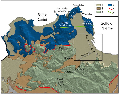
Figure 1. Geological sketch of Palermo-Belmonte Mezzagno-Trabia Mountains. Inset shows the mapped area. 1. Marine conglomerate and arenite; continental breccia, arenite, and silt (Quaternary); 2. Clay and quartz sandstone – Numidian flysh (Oligocene – Lower Miocene); 3. Limestone, marl, dolostone, and cherty limestone – Imerese basin successions (Upper Triassic – Oligocene); 4. Limestone and dolostone – Panormide platform successions (Upper Triassic – Oligocene); 5. Main thrust; 6. Track of the geological section of .
Geomorphological setting of the mountain areas () is characterized by a karst landscape along the relief on carbonates (CitationDi Maggio et al., 2012) and a river landscape along the relief on the Numidian flysch clays (CitationAgnesi, 1995; CitationBrandolini et al., 2018b; CitationDi Maggio et al., 2017).
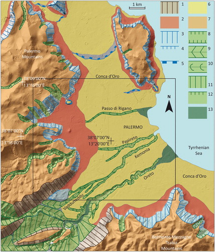
Figure 2. Geomorphological map of the original landforms due to natural processes of the Palermo area. Inset shows the mapped area. 1. Fault-line scarp; 2. Alluvial fan, colluvial talus, and scree slope; 3. Degraded and abandoned coastal cliff controlled by fault: >10 m high; 4. Degraded and abandoned coastal cliff: >10 m high; 5. Abandoned coastal cliff: <10 m high; 6. Coastal terrace surface; 7. Karstified low-relief surface in carbonate rock; 8. Fluvio-karstic and fluvial canyon; 9. V-shaped valley mainly on clay rock; 10. Trough-shaped valley; 11. Degraded fluvial erosion scarp: <35° inclined; 12. Fluvial erosion scarp: >45° inclined; 13. Alluvial plain.
The Conca d’Oro plain is set on a composite half-graben structure (; CitationDi Maggio et al., 2017). A very slight dipping wedge of Calabrian-Ionian coastal and shallow water clastic, mostly carbonate deposits from few to tens of meters thick crops out in the Conca d’Oro plain (CitationIncarbona et al., 2016). These deposits, assembled in the Marsala synthem, lie on the older Meso–Cenozoic units with strong angular unconformities (CitationAgate et al., 2017; CitationBasilone & Di Maggio, 2016; CitationDi Maggio et al., 2009; CitationISPRA, 2013a, Citation2013b).
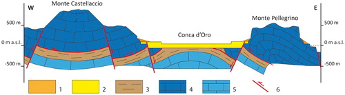
Figure 3. Geological section through the Conca d’Oro Plain (See for the track). Slope deposit (Middle Pleistocene – Holocene); 2. Coastal/marine deposit – Marsala synthem (Calabrian-Ionian); 3; Clay and quartz sandstone – Numidian flysh (Oligocene – Lower Miocene); 4. Limestone – Panormide succession of the upper tectonic units (Upper Triassic – Oligocene); 5. Limestone – Panormide succession of the lower tectonic units (Upper Triassic – Oligocene); 6 Fault or thrust.
In this plain, a Middle–Upper Pleistocene succession of marine terraces carved on the Marsala synthem deposits and the older main chain rocks, develops from 0 m up to 150 m a.s.l. (CitationDi Maggio, 2000; CitationDi Maggio et al., 2017). These terraces are characterized by large and well-preserved polycyclic wave-cut surfaces that are down-cut by some river valleys from few to ten meters deep. The wide and tall scarps that surrounded the Conca d’Oro plain are abandoned coastal cliffs derived from original fault scarps and set on the Meso–Cenozoic carbonates (). Large talus slopes bound the scarps at their base and younger deposits occur in the Conca d’Oro plain. They are formed by Middle Pleistocene–Holocene successions (; CitationAgate et al., 2017; CitationAgnesi et al., 2007; CitationBasilone & Di Maggio, 2016; CitationDi Maggio et al., 2009; CitationISPRA, 2013a, Citation2013b; CitationMartorana et al., 2018) constitute of coastal conglomerates (Buonfornello-Campofelice synthem), aeolian arenites (Polisano synthem, BLT), coastal and colluvial cemented deposits (Barcarello synthem, SIT), talus screes (Raffo Rosso synthem, RFR), and coastal, aeolian, river, colluvial, and landslide deposits (Capo Plaia synthem AFL).
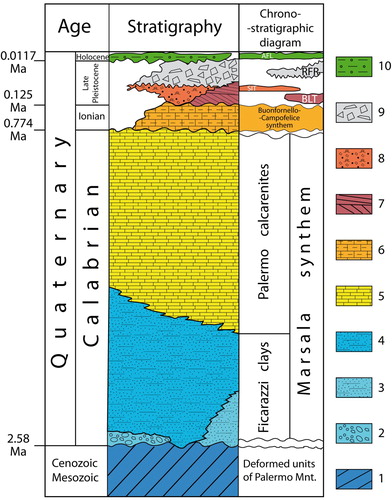
Figure 4. Stratigraphy of the Quaternary deposits in the Palermo area. BLT: Polisano synthem; SIT: Barcarello synthem; RFR: Raffo Rosso synthem; AFL: Capo Plaia synthem. 1, carbonate and terrigenous rocks; 2, conglomerates; 3, marine sands; 4, grayish clayey silts; 5, bioclastic calcarenites and sands; 6, coastal conglomerates; 7, aeolian arenites; 8, coastal conglomerates, arenites and colluvial cemented deposits; 9, cemented clast-supported breccias; 10, colluvial, river, littoral and landslide deposits.
Over the last 2700 years, during the Anthropocene, the urban area of Palermo was affected by remarkable man-made changes to topographic surface, drainage network, underground, and coastline. The main changes consist of (i) filling of river valleys; (ii) concreting, diversion and burial of riverbeds; (iii) excavation of tunnels and underground or open quarries; (iv) massive nourishment of the coast areas by means of demolition materials originating from the Second World War (CitationAgnesi, 2019; CitationBrandolini et al., 2019; CitationColumba, 1910; CitationCoroneo, 2011; CitationDi Matteo, 2002).
3. Methods
Bibliographic searches, geological and geomorphological analyses consisting of field survey, interpretation of aerial photographs and topographic maps, consultation of historical documents and maps, stratigraphic and topographic reconstruction from a number of wells and underground data were performed with the aim of defining a map of urban geomorphology.
Geomorphological studies based on field surveys and analyses of aerial photographs (Assessorato Regionale Territorio e Ambiente, ARTA, Ortofotocarta digitale IT 2000, scale 1:10,000; ARTA, Ortofoto ATA 2007-2008, pixel 0.25 m) led to the recognition of natural and man-made landforms.
Geological surveys and comparison with bibliographic data allowed the reconstruction of the geological setting of the study area, the definition of Quaternary deposits and artificial accumulations, and the accurate interpretation of landforms.
For instability landforms, the landslide inventory of the Hydrogeological Setting Plain (PAI) of Sicilia Region was consulted (http://www.sitr.regione.sicilia.it/pai/).
Underground data obtained from both bibliographic searches (CitationFloridia, 1956; CitationTodaro, 2002; Citation2004) and field surveys allowed us to detect numerous artificial ‘caves’.
Data from historical () and modern documents (CitationAgnesi, 2019; CitationColumba, 1910; CitationCoroneo, 2011; CitationCusimano et al., 1989; CitationDi Matteo, 2002, and references therein) and maps (ITM 1885, scale 1:5000; CitationColumba, 1910, scale 1:7875; NISTRI 1935, scale 1:5000; IRTA 1956, scale 1:5000; IGMI 1912, 1937, 1970, scale 1:25.000; SAS 1973, 1994, scale 1:25,000; CTR 1994, 2005 scale 1:10,000), and analyses from numerous wells (CitationCalvi et al., 2000; CitationCusimano & Di Cara, 1995) helped to reconstruct (1) the natural topography today buried by anthropic fillings, (2) the deep stratigraphy, (3) the recent geomorphological events that have affected the study area, and (4) the topographic changes produced by human activity.
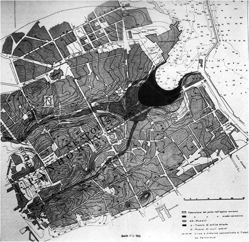
Figure 5. Historical Map of Palermo (from CitationColumba, 1910).
Achieved data were summarized in the Main Map, where rocks, deposits, and landforms were mapped following schemes and criteria proposed in geomorphological literature (CitationBrancaccio et al., 1994; CitationBrandolini et al., 2019; CitationCampobasso et al., 2018; CitationDel Monte et al., 2016; CitationPanizza, 1972, Citation1987; CitationRosenbaum et al., 2003). To point out that the rock units were grouped according to their response to geomorphological processes, as well as the landforms that were grouped on the basis to genetic criteria.
4. Results
The study area is characterized by numerous man-made forms and structures that have deeply modified the natural landscape. Genesis and ‘ancient’ (Quaternary) evolution of these landscapes are mainly controlled by the interaction between coastal processes, sea level glacio-eustatic changes and tectonic movements; its most ‘recent’ (Anthropocene) evolution is dominated by human activity.
During the Calabrian stage (about 1.5 Ma), extensional faults with displacement of hundreds of meters produced the lowering and drowning of the present-day Conca d’Oro plain, triggering coastal-to-marine deposition in a shallow water, subsiding, sedimentary environment, which marks the beginning of the formation of the future rocks of Marsala synthem. These environmental conditions lasted until the end of the Calabrian stage (about 0.8 Ma). Throughout this time, the sea that submerged the ancient Conca d’Oro also produced coastal terraces and sea caves along the margins (ancient sea cliffs evolved by former fault scarps) of the uplifting blocks bordering the Conca d’Oro plain. From the Middle Pleistocene to Holocene, tectonic uplift involved also the ‘Conca d’Oro’ area and produced its gradual emergence, triggering coastal erosion processes that migrated over time to progressively lower altitudes and generating coastal terraces. At the same time, river down-cutting affected the ancient coastal terrace surfaces, water erosion and landslides occurred along the steep slopes on carbonates and the relief on clays, and karst phenomena developed in the relief on carbonates. Until the last 2700 years, during Anthropocene, when man has profoundly changed the relief.
The evidences of these events are the natural and man-made landforms drawn in the Main Map.
4.1. Fluvial landforms
The existence of a wide flat area and a mountain relief on karstified carbonate rocks did not allow the development of a dense river network. Thus, the fluvial landforms are not extensive and are the result of down-cutting processes that affected the study area on the whole in response to the Quaternary tectonic uplift.
The most significant fluvial landforms occurring in the Conca d’Oro plain are produced by the Oreto River. In the end part of this river but before reaching the mouth, fluvial erosion scarps from few to tens of meters tall, enclosing a narrow (tens of meters wide) floodplain consisting of a thick set of fluvial deposits, produce a flat-floored valley about 2.5 km long. Upstream, with the disappearance of the floodplain at the bottom of the valley, the Oreto River creates a fluvial gorge. Downstream and in the few part not modified by man, the Oreto River shows an alluvial fluvial channel with abandoned meandering bed. With regard to the thickness of fluvial deposits, well data indicate the occurrence of valleys filled with alluvial sediments up to few tens of meters thick, owing to the rise of the sea level occurred between end of the Last Glacial Period and beginning of the Holocene Period.
In upstream zone and in the parts where the Vadduneddu/Kemonia stream has not been artificially modified, it flows into trough-shaped valleys that are produced by fillings due to denudation processes (upstream part) or anthropogenic activities (modified trough-shaped valleys).
The largest fluvial landforms occur along the mountain areas surrounding the Conca d’Oro plain, with several streams that give rise to V-shaped valleys hundreds of meters deep. At the mouth of these valleys in the Conca d’Oro plain, the streams produce alluvial fans, today partially reshaped bay man, and abruptly end their run on the plain.
Surfaces affected by Holocene colluvium produced by runoff are situated mainly at the foot of the steep slopes and along the slightly sloping slopes.
4.2. Karst landforms
Karst process is mainly developed in the Meso–Cenozoic carbonate rocks and, in particular, in the shallow-water massive limestones of the Panormide successions. Generally, in all limestone outcroppings small karst forms (karren) occur widespread such as rillenkarren, rinnenkarren, runnels, grikes, ruiniform karren, rounded karren, and pinnacles. In particular, in the geomorphological map we have represented the main surfaces densely affected by karren (scattered micro-karren surfaces); they are situated in the north-western sector of the study area.
A small solution doline on dolostone is located at the Timpone di Scirocco area, some travertine patches produced by precipitation from spring waters occurs to east of Cozzo S. Isidoro and to south of Monreale, and the entrance of two small caves indicating the development of an underground karstic system within the carbonate rocks are situated in the mountain area.
4.3. Coastal landforms
Within the Conca d’Oro plain, abandoned coastal landforms are numerous and widespread.
A wide terrace surface produced by wave-cut erosion is the most significant form. This surface develops from 0 m to about 150 m a.s.l. mainly without interruption, showing a width of about 5 km and occupying the entire investigated Conca d’Oro plain. Considering its extension and its elevation, it is a polycyclic surface typical of areas affected by low uplift rates (0.1–0.2 m/Ky; CitationDi Maggio, 2000; CitationISPRA, 2013a, Citation2013b). A degraded abandoned coastal cliff breaks the continuity of the polycyclic terrace surface; it has been detected in the north-eastern end of the study area, showing a height of 2–5 m and a length of about 2 km, and separating a lower surface located at altitude below 25 m a.s.l. and an upper surface located at altitude higher than 30 m a.s.l. These coastal landforms are carved on the Calabrian rocks of Marsala synthem. Their genesis is linked to several cycles of marine highstands of the Middle–Upper Pleistocene stages. Somewhere, the lower part of the terrace surface (altitude below 15 m a.s.l. about) is covered by coastal deposits with Strombus bubonius (CitationBuccheri, 1966; CitationFabiani, 1941) of Tyrrhenian age (Marine Isotope sub-Stage 5.5).
Along the steep slopes in Mesozoic carbonate rocks forming old abandoned coastal cliffs now highly degraded, small terrace surfaces between 170–190 m a.s.l. are located near the Boccadifalco and Baida areas. We speculate that their age may be of the late Calabrian stage.
Among the active landforms, we map three small natural beaches with mainly sandy deposits located in the northern and southern coast.
4.4. Structural landforms
Structural landforms are poorly developed. Our surveys show only few structural selective scarps set in Mesozoic carbonate rocks, where these rocks overthrust Upper Ologocene–Lower Miocene Numidian flysch clays. They were distinguished between scarps over 10 m tall (located at the north-western corner of the study area) and scarps less than 5 m tall (located at the NW flank of Cozzo S. Isidoro).
4.5. Gravitational landforms
Landslides processes affect the described above fluvial erosion scarps and abandoned coastal cliffs, and, generally, the mountain slopes. Fed by rock and debris falls/toppling/tumbles and composed of scree and landslide accumulations, large talus slopes are located at the foot of the main steep mountain slopes in carbonate rocks. Many of these talus slopes were urbanized in recent decades, representing today areas with high landslide risk (CitationCafiso & Cappadonia, 2019; cf. CitationBrandolini et al., 2007; CitationGalve et al., 2016). On the steep rock slopes, the landslide evidences are indicated by the existence of a number of detachment scarps. Finally, a small translational slide body occurs in the north-western flank of Cozzo S. Isidoro, where a carbonate block is slipped on the clayey substrate.
4.6. Man-made landforms
In the study area, many natural landforms were deeply changed by man. The coastal terrace surfaces, the talus slopes, and the bottom of the fluvial valleys located in the Conca d’Oro plain are affected by excavations and fillings and are intensively urbanized. To allow the development of urbanization, small river valleys were completely filled and are disappeared, and possible small abandoned coastal cliffs that separated terrace surfaces may have been erased or reshaped to reduce their inclination. The wide abandoned coastal cliffs, the river slopes of the large valleys, and the mountain area of more difficult access mainly retain their original features and are not very changed, except for a mountain area about 6 km NW of the Palermo center, where a large landfill is located.
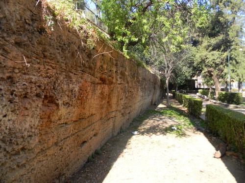
The surface changes mainly consist of a large number of excavations and fillings owing to the progressive urbanization of the city. The most numerous excavation areas are the ancient opencast quarries of the Conca d’Oro plain, whose extractive activity began in the seventh century BC (Phoenician period) and continued uninterrupted for over 26 centuries (CitationTodaro, 2004). From these quarries, the easily workable calcarenites of the Marsala synthem were extracted and used mainly as a building stone. Currently, parks and private or public gardens and buildings occupy these ancient quarry areas (). The search for valuable or better quality material account for the presence of the quarries located along mountain slopes distant from the Palermo city. From these quarries, valuable ‘marbles’ (polished limestones) and variegated jasper were extracted and used in architectural practice in various ways, mainly from the end of the sixteenth century to almost the present day (CitationAlaimo et al., 2008). Being still active or having maintained their activity until recent times, the quarries on the slopes are not affected by large man-made changes and essentially retain their original appearances and features, also because they are located in peripheral and difficult urbanization places.
Figure 6. Ancient front of an historical opencast quarry cut in the calcarenite of Marsala and located in the current public garden ‘Villa Garibaldi’, within the Palermo town.
Major excavations also involve the Notarbartolo railway station area and long stretches of the bypass road where deep underpasses were built. As previously described, the main accumulation landforms concern the fillings of ancient river valleys, coastal areas, and made-man caves. Finally, the urban expansion and the development of the road system over time involved minor excavations and fillings to reduce the differences in height.
The hydrographic network displays the most obvious changes, due to frequent floods among which the most disastrous ones occurred in the 934, 1557, 1666, 1772, and 1931 years (CitationAgnesi, 2019; CitationCusimano et al., 1989; CitationFabiani, 1931). In the sixteenth century, a stretch of the Kemonia Stream was diverted and channelled (Badami Channel) towards the Oreto River. An additional culverted channel (Filangeri) was realized in the nineteenth century. In the historic center, the stretches further downriver of the Kemonia and Papireto valleys were gradually filled by anthropogenic deposits, and their streams were channelled and tunnelled since the fourteenth century (). After a devastating flood in the 1931 year, the construction of the Boccadifalco Channel beheaded the two streams in their upstream sections and their original tributaries (Vadduneddu Stream and Vallone Paradiso River, respectively) were diverted and channelled through an artificial channel into the Oreto River. In the same time, both the artificial Passo di Rigano Channel was cut to collect the waters of the NW hydrographic network consisting of the Luparello, Borsellino, Celona and Mortillaro streams, which are today channelled underground, and the end stretch of the Oreto River was widened, rectified and concreted.
Figure 7. Palermo harbor and anthropogenic changes along the Palermo coastline.
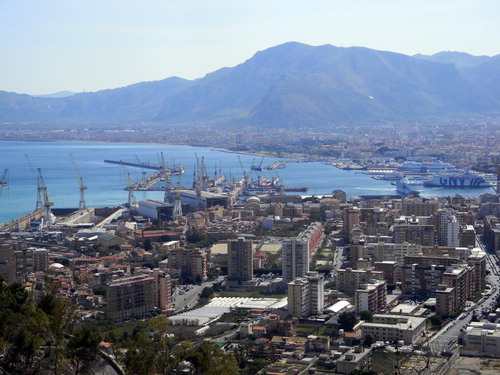
The investigated coastline is about 7 km long and was originally characterized by alternating sandy or pebbly bay beaches and small sea cliffs 1–5 m tall. Of these natural coasts, currently only short beaches and sea cliffs remain along the northern coastal sector. The heaviest coastline changes affect the harbor area (). In the second half of the sixteenth century, the south and the north quays were built owing to the progressive filling of the old harbor (la Cala area) produced by debris transported by the Kemonia and Papireto streams. Following the increase in maritime traffic, new quays were built and the south and north quays were extended between the early nineteenth and the first half of the twentieth centuries. After the serious damage suffered during the Second World War, the harbor was rebuilt (CitationCoroneo, 2011) and large stretches of the coast were covered by war rubble and filling materials ().
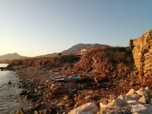
Figure 8. Rubble and filling materials of the Second World War, on which the sea produced a beach and a backwater coastal cliff, along the south coast of Palermo.
The Palermo subsoil shows several man-made caves. The underground quarries were excavated since the ninth century and remained active until the nineteenth century. Quarrying underground material made it possible to avoid taking away soil useful for agriculture, to take better quality rock levels, and to be able to work even in adverse weather conditions. Once existing for dozen of kilometers and often arranging on several levels, many underground quarries were destroyed following the post-1960 urban expansion and only a few examples remain today. The Arab aqueduct is composed of a dense network of qanāt, a set of tunnels 0.8 m wide, 1.55 m high, and several kilometers long. These tunnels collected the spring waters at the foot of the mountains and distributed them throughout the city by means of a system of serial wells. To avoid erosion, the qanāt floor shows a gradient of 2–4‰, enough to let the water flow. The Camere dello Scirocco were in vogue between the sixteenth and seventeenth centuries and were excavated near the noble country villas; today, only a few examples remain. Catacombs and ancient crypts are connected to many historic churches. Air-raid shelters were built during the Second World War; afterwards, they were filled, obliterated or transformed into parking lots. Among the most recent underground works, the railway tunnels were excavated from the 1950s end and are still under development.
5. Conclusion
The geomorphological study carried out in the urban area of Palermo town has shown a number of natural and man-made landforms that allow the reconstruction of the ‘ancient’ (Quaternary) and ‘recent’ (Anthropocene) landscape evolution.
The landform analysis has pointed out older landscapes that, during the Quaternary period, were dominated by river down-cutting and karst phenomena (in mountain area) or coastal processes (in Conca d’Oro plain). In the last 2700 years, during the Anthropocene, these landscapes were largely covered by the profound topographic changes produced by man, which are responsible of the present-day urban landscape of the study area.
The overlap of natural and artificial landforms has led the Authors to pay great attention to geomorphological mapping, taking from literature, the recently suggested methods of representation, in order to produce a map of easy and immediate reading.
The historic reconstruction of the man-made landforms has suggested that most areas including artificial ‘caves’, river valleys and stream channels filled by anthropogenic deposits, and talus slopes affected by landslides have been gradually incorporated into the urban fabric, undergoing levelling processes to mitigate their topographic profile and facilitate the urban expansion.
Also, the presence of large volumes of river or anthropogenic deposits, on which some areas of the city have been built, and the existence of many artificial scarps and excavations signify lithological and topographic factors of seismic waves velocity amplification.
In any case, the urban expansion of the town along filled river valleys, mountain flanks, and talus slopes definitely creates situations of increased geological risk due to flood, landslide and earthquake.
By all these implications, the Main Map represents a useful tool in urban planning studies.
Software
ESRI ArcGIS software was used to create a geo-database and to produce the Main Map.
Main_Map.pdf
Download PDF (21.7 MB)Acknowledgements
We are very thankful for the very helpful suggestions, comments, and revisions that the reviewers D. Cannatella, M. Furrier, and G.M. Luberti have provided.
Disclosure statement
No potential conflict of interest was reported by the author(s).
Additional information
Funding
References
- Agate, M., Basilone, L., Di Maggio, C., Contino, A., Pierini, S., & Catalano, R. (2017). Quaternary marine and continental unconformity-bounded stratigraphic units of the NW Sicily coastal belt. Journal of Maps, 13(2), 425–437. https://doi.org/10.1080/17445647.2017.1314229
- Agnesi, V. (1995). La valle dell’Oreto. Lineamenti di geologia ambientale. Uomo e Territorio, 7, 25–45.
- Agnesi, V. (2019). Palermo e l’acqua perduta. Plumelia Edizioni.
- Agnesi, V., Di Patti, C., & Truden, B. (2007). Giants and elephants of Sicily. Geological Society, London, Special Publications, 273(1), 263–270. https://doi.org/10.1144/GSL.SP.2007.273.01.20
- Alaimo, R., Giarrusso, R., & Montana, G. (2008). I materiali lapidei dell’edilizia storica di Palermo. IlionBooks Ed.
- Barbosa, T. S., de Lima, V. F., & Furrier, M. (2019). Geomorphological mapping and anthropogenic geomorphology of Conde Municipality – Paraíba [Mapeamento geomorfológico e geomorfologia antropogênica do Município do Conde – Paraíba]. Revista Brasileira de Geomorfologia, 20(3), 525–540. https://doi.org/10.20502/rbg.v20i3.1571
- Basilone, L., & Di Maggio, C. (2016). Geology of Monte Gallo (Palermo Mts, NW Sicily). Journal of Maps, 12(5), 1072–1083. https://doi.org/10.1080/17445647.2015.1124716
- Brancaccio, L., Castiglioni, G. B., Chiarini, E., Cortemiglia, G., D’Orefice, M., Dramis, F., … Onorati, G. (1994). Carta Geomorfologica d’Italia – 1:50000. Guida al rilevamento. Quaderni del Servizio Geologico Nazionale, Serie III, 4.
- Brandolini, P. (2017). The outstanding terraced landscape of the Cinque Terre coastal slopes (Eastern Liguria). In M. Soldati, & M. Marchetti (Eds.), Landscapes and landforms of Italy, world geomorphological landscapes (pp. 235–244). Springer International Publishing. https://doi.org/10.1007/978-3-319-26194-2_20.
- Brandolini, P., Cappadonia, C., Luberti, G. M., Donadio, C., Stamatopoulos, L., Di Maggio, C., … Del Monte, M. (2019). Geomorphology of the Anthropocene in Mediterranean urban areas. Progress in Physical Geography: Earth and Environment. Advance online publication. https://doi.org/10.1177/0309133319881108
- Brandolini, P., Faccini, F., Paliaga, G., & Piana, P. (2017). Urban geomorphology in coastal environment: Man-made morphological changes in a seaside tourist resort (Rapallo, Eastern Liguria, Italy). Quaestiones Geographicae, 36(3), 97–110. https://doi.org/10.1515/quageo-2017-0027
- Brandolini, P., Faccini, F., Paliaga, G., & Piana, P. (2018a). Manmade landforms survey and mapping in an urban historical center on coastal Mediterranean environment. Geografia Fisica e Dinamica Quaternaria, 41, 24–34. https://doi.org/10.4461/GFDQ.2018.41.2
- Brandolini, P., Faccini, F., Robbiano, A., & Bulgarelli, F. (2011). Geomorphology and cultural heritage of the Ponci Valley (Finalese karstic area, Ligurian Alps). Geografia Fisica e Dinamica Quaternaria, 34, 65–74. https://doi.org/10.4461/GFDQ.2011.34.7
- Brandolini, P., Faccini, F., Robbiano, A., & Terranova, R. (2007). Geomorphological hazard and monitoring activity in the western rocky coast of the Portofino Promontory (Italy). Quaternary International, 171-172, 131–142. https://doi.org/10.1016/j.quaint.2006.11.006
- Brandolini, P., Pepe, G., Capolongo, D., Cappadonia, C., Cevasco, A., Conoscenti, C., … Del Monte, M. (2018b). Hillslope degradation in representative Italian areas: Just soil erosion risk or opportunity of development? Land Degradation & Development, 29(9), 3050–3068. https://doi.org/10.1002/ldr.2999
- Buccheri, G. (1966). Contributo alla conoscenza della malacofauna di un terrazzo marino presso Palermo. Atti Accademia Gioenia di Scienze Naturali, 18, 329–332.
- Cafiso, F., & Cappadonia, C. (2019). Landslide inventory and rockfall risk assessment of a strategic urban area (Palermo, Sicily). Rendiconti Online della Società Geologica Italiana, 48, 96–105. https://doi.org/10.3301/ROL.2019.42
- Calvi, F., Contino, A., Cusimano, G., Di Cara, A., Forcada, A. F., Hauser, S., & Pellerito, S. (2000). Hydrostructures related to the Piana di Palemo aquifers and their hydrogeochemical characteristics. Memorie della Società Geologica Italiana, 55, 473–481.
- Campobasso, C., Carton, A., Chelli, A., D’Orefice, F., Dramis, F., Graciotti, R., … Pellegrini, L. (2018). Aggiornamento ed integrazioni delle Linee guida della Carta geomorfologica d’Italia alla scala 1:50.000. Progetto CARG: Modifiche ed integrazioni al Quaderno n. 4/1994. Quaderni serie III, 13(1).
- Catalano, R., Valenti, V., Albanese, C., Accaino, F., Sulli, A., Tinivella, U., … Giustiniani, M. (2013). Sicily fold-thrust belt and slab roll-back: The SI.RI.PRO. Seismic crustal transect. . Journal of the Geological Society, 170(3), 451–464. https://doi.org/10.1144/jgs2012-099
- Coates, D. R. (1974). Environmental geomorphology and landscape conservation. Vol. II: Urban areas. Hutchinson & Ross.
- Coates, D. R. (1976). Urban geomorphology (Special Paper 174). The Geological Society of America.
- Columba, G. M. (1910). Per la topografia antica di Palermo. In G. S. Cozzo (Ed.), Centenario della Nascita di Michele Amari, Vol. II (pp. 395–426). Stabilimento Tipografico Virzì.
- Cooke, R. U. (1976). Urban geomorphology. Geographical Journal, 142(1), 59–65. https://doi.org/10.2307/1796025
- Cooke, R. U., Brunsden, D., Doornkamp, J. C., & Jones, D. K. C. (1982). Urban geomorphology in drylands. Oxford University Press. https://doi.org/10.1002/esp.3290080617.
- Cooper, A. H., Brown, T. J., Price, S. J., Ford, J. R., & Waters, C. N. (2018). Humans are the most significant global geomorphological driving force of the 21st century. The Anthropocene Review, 5(3), 222–229. https://doi.org/10.1177/2053019618800234
- Coroneo, R. (2011). Storia del porto di Palermo. Marcello Clausi Editore.
- Crutzen, P. J. (2002). Geology of mankind. Nature, 415(6867), 23. https://doi.org/10.1038/415023a
- Cusimano, G., & Di Cara, A. (1995). Carta della vulnerabilità all’inquinamento degli acquiferi del territorio del Comune di Palermo. Quaderni di Geologia Applicata, Supplemento (3), Pitagora Editrice Bologna.
- Cusimano, G., Di Cara, A., Marescalchi, P., & Nastasi, P. (1989). Le alluvioni palermitane. Cronologia e cause dal 934 al 1988. Quaderni Museo G.G. Gemmellaro, 4.
- Del Monte, M., D’Orefice, M., Luberti, G. M., Marini, R., Pica, A., & Vergari, F. (2016). Geomorphological classification of urban landscapes: The case study of Rome (Italy). Journal of Maps, 12(S1), 178–189. https://doi.org/10.1080/17445647.2016.1187977
- Di Maggio, C. (2000). Morphostructural aspects of the central northern sector of Palermo Mountains (Sicily). Memorie della Società Geologica Italiana, 55, 353–361.
- Di Maggio, C., Agate, M., Contino, A., Basilone, L., & Catalano, R. (2009). Unconformity-bounded stratigraphic units of quaternary deposits mapped for the CARG project in northern and western Sicily [Unità a limiti inconformi utilizzate per la cartografia dei depositi quaternari nei fogli CARG della Sicilia nord-occidentale]. Alpine and Mediterranean Quaternary, 22, 345–364. http://www.aiqua.it/index.php/volume-22-2/204-unita-a-limiti-inconformi-utilizzate-per-la-cartografia-dei-depositi-quaternari-nei-fogli-carg-della-sicilia-nord-occidentale/file
- Di Maggio, C., Madonia, G., Parise, M., & Vattano, M. (2012). Karst of Sicily and its conservation. Journal of Cave and Karst Studies, 74(2), 157–172. https://doi.org/10.4311/2011JCKS0209
- Di Maggio, C., Madonia, G., Vattano, M., Agnesi, V., & Monteleone, S. (2017). Geomorphological evolution of western Sicily, Italy. Geologica Carpathica, 68(1), 80–93. https://doi.org/10.1515/geoca-2017-0007
- Di Matteo, S. (2002). Palermo, Storia della Città. Kalos.
- Donadio, C. (2017). Experimenting criteria for risk mitigation in fluvial-coastal environment. CSE Journal–City Safety Energy, 1, 9–14. http://journals.lepenseur.it/index.php/cse/article/view/112/70
- Ellison, R. A., Booth, S. L., & Strange, P. J. (1993). Geological mapping in urban areas. Episodes, 16(3), 383–387. https://doi.org/10.18814/epiiugs/1993/v16i3/003
- Eyles, N. (1994). Environmental geology of urban areas. Geoscience Canada, 21(4), 158–162. https://journals.lib.unb.ca/index.php/GC/article/view/3854/4368
- Fabiani, R. (1931). Considerazioni geologiche a proposito dell’alluvione del 21-22 febbraio 1931. Atti Reale Accademia Scienze Letterarie e Belle Arti di Palermo, 16(3), 10.
- Fabiani, R. (1941). Tracce di Tirreniano (strati a Strombus bubonius Lk.) entro la città di Palermo. Bollettino della Società di Scienze Naturali ed Economiche di Palermo, 23, 3–8.
- Floridia, G. B. (1956). Notizie sul sottosuolo della città di Palermo. Rivista Mineraria Siciliana, 39, 111–125.
- Galve, J., Cevasco, A., Brandolini, P., Piacentini, D., Azañón, J. M., Notti, D., & Soldati, M. (2016). Cost-based analysis of mitigation measures for shallow-landslide risk reduction strategies. Engineering Geology, 213, 142–157. https://doi.org/10.1016/j.enggeo.2016.09.002
- Incarbona, A., Contino, A., Agate, M., Bonomo, S., Calvi, F., Di Stefano, E., … Sprovieri, R. (2016). Biostratigraphy, chronostratigraphy and paleonvironmental reconstruction of the Palermo historical centre quaternary succession. Italian Journal of Geosciences, 135(3), 512–525. https://doi.org/10.3301/IJG.2015.45
- ISPRA. (2013a). Foglio 594–585 Partinico – Mondello. Carta Geologica d’Italia alla scala 1:50.000. Servizio Geologico d’Italia, Istituto Superiore per la Protezione e la Ricerca Ambientale (ISPRA). Assessorato Territorio e Ambiente, Regione Siciliana.
- ISPRA. (2013b). Foglio 595 Palermo. Carta Geologica d’Italia alla scala 1:50.000. Servizio Geologico d’Italia, Istituto Superiore per la Protezione e la Ricerca Ambientale (ISPRA). Assessorato Territorio e Ambiente, Regione Siciliana.
- Luberti, G. M., Vergari, F., Pica, A., & Del Monte, M. (2019). Estimation of the thickness of anthropogenic deposits in historical urban centres: An interdisciplinary methodology applied to Rome (Italy). Holocene, 29(1), 158–172. https://doi.org/10.1177/0959683618804630
- Lucchetti, S., & Giardino, M. (2015). Historical archives data for the reconstruction of geomorphological modifications in the urban area of Turin (NW Italy). In G. Lollino, A. Manconi, J. Clague, W. Shan, & M. Chiarle (Eds.), Engineering geology for society and territory, climate change and engineering geology, Vol. 8 (pp. 447–452). Springer International Publishing.
- Martorana, R., Agate, M., Capizzi, P., Cavera, F., & D’Alessandro, A. (2018). Seismo-stratigraphic model of ‘La Bandita’ area in the Palermo Plain (Sicily, Italy) through HVSR inversion constrained by stratigraphic data. Italian Journal of Geoscience, 137(1), 73–86. https://doi.org/10.3301/IJG.2017.18
- Mozzi, P., Fontana, A., Ferrarese, F., Ninfo, A., Campana, S., & Francese, R. (2016). The Roman city of Altinum, Venice Lagoon, from remote sensing and geophysical prospection. Archaeological Prospection, 23(1), 27–44. https://doi.org/10.1002/arp.1520
- Panizza, M. (1972). Schema di legenda per carte geomorfologiche di dettaglio. Bollettino della Società Geologica Italiana, 91, 207–237.
- Panizza, M. (1987). La cartografia tematica delle Scienze della Terra nella pianificazione territoriale. Memorie della Società Geologica Italiana, 37, 503–509.
- Rosenbaum, M. S., McMillan, A. A., Powell, J. H., Cooper, A. H., Culshaw, M., & Northmore, K. J. (2003). Classification of artificial (man-made) ground. Engineering Geology, 69(3), 399–409. https://doi.org/10.1016/S0013-7952(02)00282-X
- Szabò, J. (2010). Anthropogenic geomorphology: Subject and system. In J. Szabò, & D. David Land Lòczy (Eds.), Anthropogenic geomorphology (pp. 3–10). Springer.
- Teixeira Guerra, A. J. (2011). Geomorfologia Urbana. Bertrand Brasil.
- Todaro, P. (2002). Guida di Palermo Sotterranea. L’Epos.
- Todaro, P. (2004). Le cave di calcarenite del palermitano: Mucati e pirrere. In S. Sammatano (Ed.), Cave – Arte e Cultura (pp. 29–42). Istituto Statale d’Arte.