
ABSTRACT
We describe and share reconstructed data of the historical railway network of Galicia and Austrian Silesia – two regions of the Habsburg Empire that covered more than 80 000 km2 that are currently divided among Czechia, Poland and Ukraine. The network dataset includes the times of railway appearance and of the most dynamic development until 1914, which marked the outbreak of the First World War. Most of the lines were reconstructed based on OpenStreetMap data, and the lines, which were closed down between 1914 and 2019 and are no longer available in spatial datasets, were reconstructed based on high-resolution satellite imagery and historical maps. Altogether, the network dataset covers nearly 5000 km on 127 lines. The data are accompanied by a set of attributes, i.e. the year of construction, length, starting point, finish point, and type (normal, narrow-gauge, etc.), and are available for download in the shp format.
1. Introduction
Railway history started in the nineteenth century in Great Britain and soon included a large part of Europe, triggering enormous changes in socio-economic systems (CitationMartí-Henneberg, 2013; CitationTurnock, 2001). Railways enabled the transport of a large volume of goods, which resulted in connections within and between industrial centres and harbours (CitationDe Block, 2011; CitationIvan et al., 2012), and created opportunities for large social groups to move, which resulted in migrations (Citationda Silveira et al., 2011), commuting (CitationDe Block & Polasky, 2011) and tourism (CitationCirer-Costa, 2012). Railways were soon understood as a strategic form of transportation that triggered the processes of nationalization of privately established lines as a result of the political empowerment of nineteenth-century empires. All the above-mentioned processes rapidly shaped the European railway network; however, the processes were not uniform over the continent or even within the countries. Galicia and Austrian Silesia – two border regions at the edge of a large multinational empire – provided good examples of all the processes and phenomena listed above. The railways in these countries were constructed mainly for economic reasons, in particular to serve the most important industrial plants in the two regions – the coal mines and steel mills around Ostrava (Silesia) as well as the salt and crude oil mines in Galicia (Wieliczka and Bochnia, which were east of Krakow and the central-eastern Carpathians, respectively). In fact, the very first lines on this area were built by private enterprises to connect the cities of Vienna, Krakow, Warsaw and Wrocław to the Upper Silesian Coal Basin. The line between the two main cities in Galicia – Krakow and Lviv – also served the salt mines, and the Galician Transversal Railway – the construction of which was implemented by the state for mainly strategic reasons – passed through oil fields in the Carpathians.
To study the railway construction processes and the impact of the railways on migrations, economy, and land use change, proper historical GIS data on railway development is needed. However, these data were not available, as such data acquisition is a time-consuming process. In this paper, we describe the development of the railway networks in two provinces located in the northern part of the Habsburg Empire – Austrian Silesia and Galicia (more than 80 000 km2). In this territory, the entire process of railway development was done under one entity. This explains the cohesion of this railway system (CitationTaczanowski, 2019). Galicia belonged to the Habsburg Monarchy from the partition of Poland in 1772 until the end of the First World War in 1918. Now, the western part of the former province belongs to Poland, and the eastern part is located in Ukraine. Austrian Silesia, consisting of two parts, was part of the Medieval Duchy of Silesia, located on the Czech-Polish borderland. The western part, known as Opava Silesia, is currently located almost entirely in Czechia, while the eastern part, known as Cieszyn Silesia, is now divided between Poland and Czechia ().
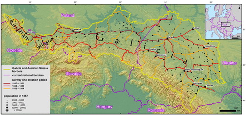
Figure 1. Historical railway network in relation to the historical and contemporary political boundaries.
We show here the main steps of the development process since the establishment of the first lines in the area in 1847 and end it in 1914, just before the outbreak of the First World War. The data, which are in the form of a GIS database, are available for download as shp file.
2. Materials and Methods
2.1. Materials
The network dataset reconstruction was based on the current railway network data that is available in the OpenStreetMap (OSM) and auxiliary datasets. The auxiliary datasets include the Austrian third military survey maps (1:75 000) that were published between 1869 and 1887 but updated up until 1918 (Militärische Spezialkarte … ), Polish topographic maps WIG (1:100 000) from the 1930s (Mapa Taktyczna …), and high-resolution contemporary satellite imagery (Bing Maps available in ArcMap basemap). The timing of the construction and course of the lines were also referenced from the railway atlases of Poland and Czechia (CitationHudec, 2006; CitationStankiewicz & Stiasny, 2010).
2.2. Network dataset reconstruction
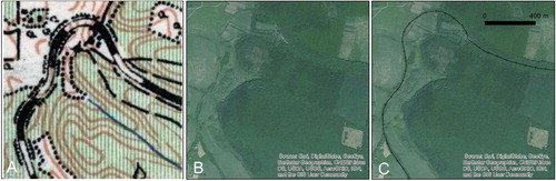
As the OSM dataset shows a contemporary railway network, we first downloaded the railway data in shp form for the whole study area and then deleted all the lines constructed later than in 1914, according to the railway atlases of Poland and Czechia (CitationHudec, 2006; CitationStankiewicz & Stiasny, 2010). While the lines currently function as double-track lines, we deleted one of the parallel tracks from the database, leaving only one line, which reflected the situation at the time of construction in the nineteenth century. In the next step, based on the information from the atlases (CitationHudec, 2006; CitationStankiewicz & Stiasny, 2010), we have added an attribute indicating the year of creation to each of the lines constructed before June 1914 – the outbreak of the First World War. Next, we verified which lines, constructed before 1914, were closed down before 2019 and could no longer be found in the OSM database. In such cases, we used historical maps to consult the approximate route and then used high-resolution Bing imagery to manually vectorise the detailed line course ().
Figure 2. Reconstructed railway of a section of the line that no longer exists between Vovkiv (ukr. Во´вків, pol. Wołków) and Pidhajtsi (ukr. Підгайці, pol. Podhajce), current Ukraine, constructed in 1909; source: Polish military topographic map WIG 1:100 000 (A); Bing Imagery, ArcMap basemap (B, C).
While we know that there were some line corrections made in the past, compared to the current situation, we also corrected the shp layer based on the historical maps mentioned above () and added the appropriate comments about the line in the database. To ensure the correct topology, the lines were connected when needed, and the topology was verified with the ArcMap topology tools. Finally, we added an attribute to the lines that described the type of gauge (normal, narrow), start and final station and additional comments (if needed). In this attribute, we put the information about closures of the line or corrections done on specific sections of the line. Our work was focused on railway lines and did not contain all the sidings constructed locally, e.g. to serve industrial sites. As many of the station names have changed since 1914, we decided to use the current names on the map. However, the list of the names, according to the 1914 timetable (Österreichisches Kursbuch 1914, Citation1987), can be found in the Supplemental Material.
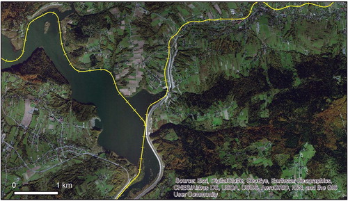
Figure 3. Reconstruction of the closed section between Wadowice and Skawce and the redesigned section between Kraków and Zakopane that was built due to water reservoir construction in the Polish Carpathians. In the database, in each case, the original shape from times of construction of the lines in 1884 and 1899 was reconstructed; source: Bing Imagery, ArcMap basemap.
3. Results
3.1. Period 1847–1861
To present the network development, we have chosen as the first period the time between the appearance of the first railways in the region and the construction of the Galician Railway of Archduke Charles Louis (ger. k.k.priv. Galizische Carl Ludwig-Bahn (CLB)), which reached the capital of Galicia, Lviv, in 1861. In Galicia, the railway connections appeared first in the northwest, where the Habsburg Empire bordered the Kingdom of Prussia and the Russian Empire. In fact, the first railway line in this province – opened in 1847 – connected Krakow with the Prussian border (CitationDemel, 1954). It was aimed not only at creating the opportunity to connect the industrial centre in Upper Silesia, which was located in Prussia with Krakow but also at connecting Warsaw, which was at the time located in the Russian Empire, through Galicia with Vienna. In the following years, the main direction of railway development in Galicia went to the east, along the Carpathian Mountains, and connected Krakow with Lviv (1861); these were the most important cities in the region. In Austrian Silesia, the first railway line also appeared in 1847 when the Emperor Ferdinand Northern Railway, for which construction was launched in Vienna in 1837, reached Ostrava and Bohumin. This large-scale private enterprise was active not only in railway construction and operation but also in the coal and steel industry around the Ostrava region – the main heavy industry region in the Habsburg Empire. When the section from Bohumin to Trzebinia (station on the line on the Krakow-Prussian border) was finished in 1856, a direct connection between Vienna and Galicia was finally opened (CitationHorn, 1970). The most important regional and industrial centres were quickly connected to the main west–east trunk line, which linked Opava, the capital of Austrian Silesia (1855); the industrial city of Bielsko (1855); and salt mines in Wieliczka (1857).
3.2. Period 1862–1884
The second period we have chosen to present reached from the construction of the first railway connection to Lviv until the completion of the Galician Transversal Railway (ger. Galizische Transversalbahn). In this period, the first north–south lines passing through the Carpathians and connecting Galicia with Slovakia (then in Hungary) were opened: from Przemyśl via Łupków Pass towards Medzilaborce (1874) and from Prešov, which is in present-day Slovakia, via Plaveč to Tarnów (1876). Important investments took place in eastern Galicia and the neighbouring province of Bukovina thanks to the constructions of lines from Lviv to Chernivtsi (ukr. Чернівці´) to the capital of Bukovina in 1866 and to Brody (ukr. Броди) in 1869 (at the Russian border). Additionally, the very important connection of Bohumin (in Austrian Silesia) with Žilina (current Slovakia) was completed in 1871, as the first section of the main line to Košice, which was critical for the economic development of Slovakia at the time. The line is known as the Košice-Bohumín Railway (czech. Košicko-bohumínská dráha, slov. Košicko-bohumínska železnica, ger. Kaschau-Oderberger Bahn, hun. Kassa-Oderbergi Vasút) (CitationSchreier, 2009). This period ended with the construction of the Galician Transversal Railway, which was the first important state investment in the rail industry in the province. Additionally, in 1884, the Imperial Royal Austrian State Railways (kkStB) were created, which clearly demonstrated the direct interest of the state in railway construction and operation (CitationKaiser & Knipping, 2012). The Galician Transversal Railway, which opened in the same year, connected Čadca, which is in present-day Slovakia, with Husiatyn, which is in current Ukraine (in 1884), on the former Galician-Russian border. The line was more than 800 km long, going through several towns located in the Carpathians, serving crude oil mines and finally – which was even more crucial – becoming a strategically important second connection of West and East Galicia with the central regions of Austria-Hungary (CitationStankiewicz & Wieczorek, 2009). In Austrian Silesia, the lines from Olomouc to Opava (1872) and from Opava to Głuchołazy (ger. Ziegenhals, czech. Hlucholazy) in Prussia were completed.
3.3. Period 1885–1914
The last period presented in this paper includes completing railway investments in the regions of Galicia and Austrian Silesia and was disrupted by the outbreak of the First World War. This was generally a period of regional railway construction. Lines of this type were relatively short sections serving local centres that had been omitted by the existing main lines as well as connections to tourist centres in the Carpathians – such as the future ‘winter capital of Poland’, Zakopane (1899), and a spa resort in Krynica (1911) (CitationOpaliński, 2012). In the eastern part of Galicia, many connections from Lviv to the vicinity of the Russian boundaries were created, and at the same time, the railway crossed the Eastern Carpathians in three locations, integrating Galicia with the so-called Carpathian Ruthenia (ukr. Карпатська Русь) and eastern Slovakia. In the western part of Galicia, a new connection towards the north to the border with Russia was created, and the link between Galicia and Austrian Silesia via the line from Kojetin to Kalwaria, which was known as the Silesian and Galician Towns Railway (ger. Schlesische und Galizische Städtebahnlinie), was completed in 1888 (CitationĆwikła, 2018).
4. Discussion and conclusions
The paper presents the development of the railway network in the historical regions of Galicia and Austrian Silesia, which formerly belonging to the Habsburg Empire and are now located in Czechia, Poland and Ukraine. The main advantage of this paper is the construction of a spatial database of the railway network for the period 1847-1914. Although many researchers have discussed the impacts of railway construction on socio-economic processes in the past (CitationKerstin et al., 2018; CitationMurzyn-Kupisz & Gwosdz, 2011), the original data were usually not shared with readers. For times when we know that historical processes influenced the current state of countries and regions (CitationGrosfeld & Zhuravskaya, 2015) – of which railway systems are a very good example (CitationKról & Taczanowski, 2016; CitationTaczanowski, 2012) – or impacted the current ecosystem functioning (CitationMunteanu et al., 2017), historical geography is still rarely ‘data rich’. This was our main reason for sharing high-quality spatial data with the broad range of readers, who may appropriately use it in various types of research.
Our methodology, which was based on the use of OSM data, enabled us to minimize the positional error that is typical of any kind of historical GIS data produced by using historical maps (CitationLeyk et al., 2005; CitationLieskovský et al., 2018). However, the historical maps themselves were also used in the reconstructions because contemporary GIS databases do not provide historical data. Although there are initiatives that focus exclusively on historical GIS, such as https://histosm.org, their functionality and resources are far from what is available in contemporary web-services. Moreover, many historical GIS-oriented services offer data with lower temporal or spatial resolution when compared to the current data. In our case, both the spatial and temporal quality are fully comparable to contemporary data. Although our database was presented for a relatively large region of Central Europe, offering detailed information suitable even for large-scale research, we are aware that our network dataset might not be fully complete. Because we were focused on the public railway lines, we did not reconstruct all the local sidings, which were developed especially in the industrial region of Silesia. However, the impact of such investments fully depended on the existence of main lines in the proximity, which is covered by our database.
We believe that the data we are sharing with the scientific community offers new possibilities for studying the impact of historical socio-economic processes on the current functioning of regions or ecosystems. Recently, the importance of historical processes in solving future challenges has been noticed by scholars (CitationGingrich et al., 2019), and we believe our dataset may be useful and contribute to similar research in the future.
Open Scholarship

This article has earned the Center for Open Science badge for Open Data. The data are openly accessible at Mendeley.
Data
Shapefile of the railway lines constructed in the period 1847-1914. The layer is projected in the Lambert azimuthal equal area projection (ETRS_1989_LAEA).
The layer contains a set of attributes:
L_ID – line ID number used in the study
Start – starting point of the line
Finish – finish point of the line
Date – year of line construction
narrow_g – if the line was created as narrow gauge (0,1)
Comments – comments indication line close-down or corrections
Name – name of the line in 1884 (presented on the lower right map)
Software
All operations were carried out in ArcMap 10.6.
Supplemental Material
Download PDF (444.3 KB)Supplemental Material
Download GIF Image (61.2 MB)
Main Map.pdf
Download PDF (15.5 MB)Acknowledgements
The authors would like to thank the reviewers (Bieke Cattoor, Gad Schaffer and Krzysztof Wiedermann) and the associate editor for their valuable comments and suggestions.
Disclosure statement
No potential conflict of interest was reported by the author(s).
Data availability statement
The data used in this study (railway network dataset) are openly available in the Mendeley Data Repository at https://doi.org/10.17632/h2gzf2pggm.1.
Additional information
Funding
References
- Cirer-Costa, J. C. (2012). The beginnings of tourism in Majorca. 1837-1914. Annals of Tourism Research, 39(4), 1779–1796. https://doi.org/10.1016/J.ANNALS.2012.06.004
- Ćwikła, M. (2018). Koleje lokalne zachodniej Małopolski. Cz. I Kalwaria Lanckorona - Bielsko Biala, Eurosprinter.
- da Silveira, L. E., Alves, D., Lima, N. M., Alcântara, A., & Puig, J. (2011). Population and railways in Portugal, 1801–1930. Journal of Interdisciplinary History, 42(1), 29–52. https://doi.org/10.1162/JINH_a_00204
- De Block, G. (2011). Designing the Nation The Belgian railway project, 1830—1837. Technology and Culture, 52(4), 703–732. https://doi.org/10.1353/tech.2011.0145
- De Block, G., & Polasky, J. (2011). Light railways and the rural–urban continuum: Technology, space and society in late nineteenth-century Belgium. Journal of Historical Geography, 37(3), 312–328. https://doi.org/10.1016/J.JHG.2011.01.003
- Demel, J. (1954). Początki kolei żelaznej w Krakowie. Towarzystwo Miłośników Historii i Zabytków Krakowa.
- Gingrich, S., Lauk, C., Niedertscheider, M., Pichler, M., Schaffartzik, A., Schmid, M., Magerl, A., Le Noë, J., Bhan, M., & Erb, K. (2019). Hidden emissions of forest transitions: A socio-ecological reading of forest change. Current Opinion in Environmental Sustainability, 38, 14–21. https://doi.org/10.1016/J.COSUST.2019.04.005
- Grosfeld, I., & Zhuravskaya, E. (2015). Cultural vs. Economic legacies of empires: Evidence from the partition of Poland. Journal of Comparative Economics, 43(1), 55–75. https://doi.org/10.1016/J.JCE.2014.11.004
- Horn, A. (1970). Die Kaiser-Ferdinands-Nordbahn, Bohmann, Wien.
- Hudec, Z. (2006). Atlas drah České republiky. Malkus. Praha.
- Ivan, I., Boruta, T., & Horák, J. (2012). Evaluation of railway surrounding areas: The case of Ostrava city. Urban Transp. XVIII-Urban Transp. Environ. 21st Century, 128, 141–152. https://doi.org/10.2495/UT120131
- Kaiser, W., & Knipping, A. (2012). Österreich. Die Eisenbahngeschichte. Das große Album.
- Kerstin, E., Alvarez-Palau, E. J., & Martí Henneberg, J. (2018). Transportation and regional inequality: The impact of railways in the Nordic countries, 1860–1960. Journal of Historical Geography, 62, 51–70. https://doi.org/10.1016/j.jhg.2018.05.001
- Król, M., & Taczanowski, J. (2016). Regionalne przewozy kolejowe w Polsce, Czechach i na Słowacji. Oficyna Wydawnicza SGH-Szkoła Główna Handlowa w Warszawie, Warszawa.
- Leyk, S., Boesch, R., & Weibel, R. (2005). A conceptual framework for uncertainty investigation in map-based land cover change modelling. Transactions in GIS, 9(3), 291–322. https://doi.org/10.1111/j.1467-9671.2005.00220.x
- Lieskovský, J., Kaim, D., Balázs, P., Boltižiar, M., Chmiel, M., Grabska, E., Király, G., Konkoly-Gyuró, É, Kozak, J., Antalová, K., Kuchma, T., Mackovčin, P., Mojses, M., Munteanu, C., Ostafin, K., Ostapowicz, K., Shandra, O., Stych, P., & Radeloff, V. C. (2018). Historical land use dataset of the Carpathian region (1819–1980). Journal of Maps, 14(2), 644–651. https://doi.org/10.1080/17445647.2018.1502099
- Martí-Henneberg, J. (2013). European integration and national models for railway networks (1840–2010). Journal of Transport Geography, 26, 126–138. https://doi.org/10.1016/J.JTRANGEO.2012.09.004
- Mapa Taktyczna Polski WIG, 1:100000, 1931-1938, Wojskowy Instytut Geograficzny, Warszawa.
- Militärische Spezialkarte der österreichisch-ungarischen Monarchie, 1:75000, 1869-1887 (−1914), Militärische Spezialkarte der österreichisch-ungarischen Monarchie, Wien.
- Munteanu, C., Kuemmerle, T., Boltiziar, M., Lieskovský, J., Mojses, M., Kaim, D., Konkoly-Gyuró, É, Mackovčin, P., Műller, D., Ostapowicz, K., & Radeloff, V. C. (2017). Nineteenth-century land-use legacies affect contemporary land abandonment in the Carpathians. Regional Environmental Change, 17(8), 2209–2222. https://doi.org/10.1007/s10113-016-1097-x
- Murzyn-Kupisz, M., & Gwosdz, K. (2011). The changing identity of the central European city: The case of Katowice. Journal of Historical Geography, 37(1), 113–126. https://doi.org/10.1016/J.JHG.2010.04.001
- Opaliński, D. (2012). Dzieje kolei normalnotorowych na obszarze byłej Galicji. In D. Keller (Ed.), Dzieje kolei w Polsce, Europsrinter, Muzeum w Rybniku, Rybnik (pp. 421–444).
- Österreichisches Kursbuch 1914. (1987). Wien.
- Schreier, P. (2009). Příběhy z dějin našich drah. Kapitoly z historie českých železnic do roku 1918.
- Stankiewicz, R., & Stiasny, M. (2010). Atlas linii kolejowych Polski 2010. Eurosprinter.
- Stankiewicz, R., & Wieczorek, C. (2009). Kolej Transwersalna. Eurosprinter.
- Taczanowski, J. (2012). A comparative study of local railway networks in Poland and the Czech Republic. Bulletin of Geography. Socio-Economic Series, 18, 125–139. https://doi.org/10.2478/v10089-012-0025-1
- Taczanowski, J. (2019). Das österreichisch-ungarische Eisenbahnnetz in den Nachfolgestaaten der Monarchie zwischen 1918 und 1939. Die Fälle von Polen und der Tschechoslowakei,. Siedlungsforsch. Archäologie - Geschichte – Geogr. 39, (in print).
- Turnock, D. (2001). Railways and economic development in Romania before 1918. Journal of Transport Geography, 9(2), 137–150. https://doi.org/10.1016/S0966-6923(00)00046-6