
ABSTRACT
A detailed geomorphological mapping of the Po River fluvial terraces into Turin was performed through a field survey. Although Turin is crossed by the Po River, most of the town is built on the extended alpine outwash fans linked to its tributaries (essentially fed by the Dora Riparia Basin), made by 20–60 m thick gravel with sand lenses, or on erosional terraces (T1 and T2) shaped by the Po River into these sediments. Only a small sector of the town is built on a narrow belt formed by thin soft sand deposited by the Po, forming depositional terraces (T3 and T4) entrenched in the alpine fans. This research allowed us to recognize three steps in the geological evolution of the area: the construction of the alpine fans (Last Glacial Maximum), the first flow of the Po River that erodes the tributary sediments (Lateglacial-Holocene) and the deposition by Po River (Holocene).
1. Introduction and previous work
Turin is located in the western sector of the Po Plain, corresponding to a narrow strip between the Alps and Turin Hill, downstream the Rivoli-Avigliana End-moraine System (RAES) extended at the outlet of the Dora Riparia Valley (Insert A in the Main Map). The aim of this research was the mapping of the 14 km long Turin eastern sector, along the Po River, which also comprises a small part of the Moncalieri town (Insert B in the Main Map). This study, developed through a detailed geological survey, was finalized to furnish an updated geological map useful to plan any modification interventions to the territory.
The distribution of sediments in the Turin Plain was reported in the official maps that indicate thin fluvial Quaternary sediments covering a sub-horizontal buried erosional surface shaped in the Tertiary succession (CitationBortolami et al., 1969; CitationFesta et al., 2009; Piana et al., Citation2017).
The western, northwestern and northern slopes of the Turin Hill preserve fluvial terraced successions (700–280 m a.s.l.) up to 480 m high above the current Po level. They are linked to ancient trends of the Dora Riparia and Stura di Lanzo rivers (paleo Dora in A) as confirmed by compositional analysis of the sediments (CitationBarbero et al., 2007; CitationForno et al., 2002; CitationForno & Lucchesi, 2005; CitationVezzoli et al., 2009). These alpine watercourses therefore deposited wide alluvial fans that reached the Turin Hill, allowing us to exclude that the Po River flowed at the NW hill foot before the Lateglacial-Holocene.
Figure 1. (A) The fluvial succession mapped in Turin Hill proved that up to LGM the hydrographic pattern was formed by a paleo Dora River, that flowed on the western and northwestern slopes of Turin Hill, and a paleo Po River that flowed through its southern side. (B) A postglacial overflow phenomenon gave rise to the current location of the Po River flowing towards the northwest at the NW foot of Turin Hill (neo Po). The inhabited area of Turin and suburbs (light yellow), the Turin municipality boundary (purple line), the RAES (green) and peaty sediments in the Moncalieri-La Loggia quarries (q) are also reported. PTF: Padane Thrust Front; TTDZ: T. Traversola Deformation Zone; RFDZ: Rio Freddo Deformation Zone (modified from CitationForno et al., 2018).
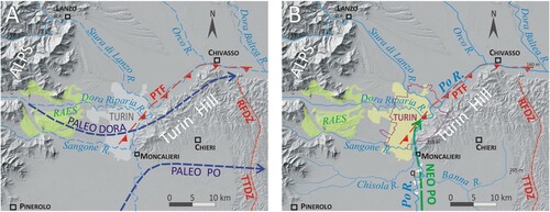
Indeed, the fluvial silty sediments and the wide abandoned meanders (1–2 km of radius of meander-bend curvature) preserved in the Turin Hill southern slope show that the Po River flowed south of this hill until the Last Glacial Maximum (LGM) (paleo Po in A), i.e. in a different position than Turin (CitationCarraro et al., 1995; CitationCompagnoni & Forno, 1992; CitationForno & Lucchesi, 2016). The trend of the Po terraces, parallel to the ancient Dora terraces, suggests that the current location of the Po River at the foot of Turin Hill northwestern slope was reached through an overflow phenomenon, by which the current Po (neo Po in B) reused a previous trend of the Dora Riparia River favoured by the uplift of the Poirino Plateau (CitationForno et al., 2018).
Chronological references for the Po River sediments in the plain south of Turin were supplied by paleontological remains (mammals and pollens) and chronological data (radiocarbon ages) essentially from the Moncalieri-La Loggia quarries (CitationTropeano & Olive, 1989 with references) (), while no dating comes from the town area (CitationForno et al., 2018).
2. Methods
The 1:15,000 Geological Map, that covers an area of about 40 km2, was surveyed at a 1:5,000 scale. The topographic base is taken from the Carta Tecnica Regionale of the Regione Piemonte at a 1:10,000 scale (CTR raster_10k series in the G4 TIFF format, derived from aerial photos of 1991–1995; Coordinate System WGS 1984 UTM Zone 32N). The Quaternary fluvial succession is subdivided into different stratigraphic units based on allostratigraphic and morphostratigraphic criteria. In detail, these units consist of fluvial sediments forming depositional terraces, referred as Unconformity Boundary Stratigraphic Units (UBSU), or they are landforms without sediments (erosional terraces), reported as morphological units (CitationSalvador, 1994).
The different units are defined according to terrace features (elevation, lateral continuity and morphology), sedimentary facies of the associated deposits and degree of soil development. Soil and sediment matrix colour is defined using the Munsell Soil Color Chart. The sediments are also distinguished for feeding basins, using the overall petrographic composition and especially the presence or absence of marker lithologies.
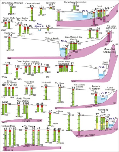
Logs of 126 boreholes (wells, piezometers and geognostic drillings) published on the Geoportale Arpa Piemonte were carefully reviewed (red numbers in the Main Map), in addition to the direct observation of the cores deriving from 6 recent boreholes (black numbers). The logs are shown in and through 22 cross-sections derived from the DTM of the same Geoportale. The main difficulties encountered during the survey are due to the strong anthropic reshaping of the natural landscape in the urban environment and to the scarcity of outcrops. A radiocarbon AMS dating on a woody macrorest (log 74) was carried out by the Laboratory of Ion Beam Physics, ETH Zürich (sample ETH-97748) and calibrated using the OxCal v4.3.2 (CitationBronk Ramsey, 2017) and IntCal13 calibration dataset (CitationReimer et al., 2013) with a 2σ range.
3. Stratigraphy
Turin shows a total extension of 130 km2 with location of most of the inhabited area on the plain (105 km2, 80% of Turin extension), consisting of Quaternary fluvial sediments (Insert C in the Main Map). Only the small hilly sector was built directly on the Tertiary succession.
The subsoil of Turin consists of a marine-deltaic complex, overlapping proglacial fluvial sediments connected to RAES (Turin Unit) and an entrenched succession of fluvial terraces linked to different lateglacial and postglacial watercourses. In detail, the survey data suggest that the terraces along the Po River consist of four units: Molinette Unit (T1), Murazzi Unit (T2), Vallere Unit (T3) and Meisino Unit (T4). These units are heteropic with the sediments connected to alpine tributary (Vanchiglia Unit and Parco Stura Unit) and with hilly tributaries (Valsalice Unit and Sassi Unit). The large quantities of anthropogenic deposits, essentially forming mounds, river embankments and bank defenses, are also mapped.
3.1. Pliocene succession
The subsoil below the Turin Plain is formed by part of the marine succession that diffusely crops out in Turin Hill (Eocene-Pliocene), referred to as Tertiary Piedmont Basin (CitationBiella et al., 1997; CitationGelati & Gnaccolini, 1982), undifferentiated on the Main Map. This succession is deformed in an asymmetrical NW-verging anticline with a SW-NE axis, that overthrusts onto the Po Plain foredeep along the Padane Thrust Front (Insert A in the Main Map), buried by the Quaternary fluvial sediments of the plain (CitationCastellarin, 1994; Mosca et al., Citation2010).
The more recent units consist of Pliocene sediments subdivided into the overlapping Argille Azzurre (from upper epibathyal to circalittoral marine clay) (), Asti Sand (circalittoral and littoral marine sand) and Villafranchian succession (deltaic and fluvial deposits). This succession forms a wide buried erosional surface in the shallow subsoil of the Turin Plain (10–30 m of depth, and ) on which the outwash and fluvial sediments of the Po Plain rest (CitationBoano et al., 2004; CitationDela Pierre et al., 2003; CitationForno et al., 2015).
Figure 2. The Pliocene marine succession (M) (Argille Azzurre), on which the fluvial sediments of the Vallere Unit lie, was crossed at low deep (23 m) by the Botanic Garden borehole (log 81).

Figure 3. Stratigraphic logs along the Po River in southern Turin: the RAES and Po sediments are reported in white and light blue colour respectively. Numbers refer to the borehole location in the Main Map.
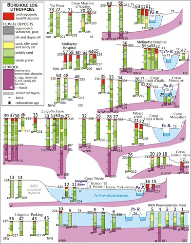
Figure 4. Stratigraphic logs along the Po River in northern Turin: the RAES and Po sediments are reported in white and light blue colour respectively. See for the legend.
3.2. Outwash sediments referred to the Turin unit connected to RAES proglacial fans
The wide fans on which most of Turin was built are essentially preserved on the left side of the Po River between 240 and 233 m, 18–20 m higher than the mean Po level, while they only form small relicts on its right side at the foot of Turin Hill, deeply incised by the current watercourses.
These fans consist of clast-supported gravel with minor lenses of medium to coarse sand, well described in previous works (CitationForno et al., 2018) and here referred to as Turin Unit. The gravel is formed by pebbles and cobbles, with rare boulders up to 50 cm, with a prevalence of well-rounded elongated pebbles derived from a long-distance fluvial transport. This unit essentially shows a light grey colour (10 YR 7/2) and unweathered clasts. Boulders of considerable size (approximately 1 m in diameter) were found in the Intesa Sanpaolo sky-scraper excavation at 32–33 m of depth (Insert C in the Main Map), forming a layer probably connected with glacial route phenomena (CitationForno et al., 2018).
The very varied petrographic composition () is in agreement with a supply from the tributary alpine watercourses of the western sector of the Alps. A prevalent supply from the Dora Riparia Basin is suggested by various lithotypes of the Pennidic Domain as peridotite (from the Lanzo Ultramafic Unit, LZ), abundance of serpentinite (from undifferentiated oceanic units) and gneiss, micaschist, marble and dolomitic marble (from the Dora Maira and Ambin massifs, DM and AB) (Insert A in the Main Map). On the contrary, lithotypes diffused in the southwest sector of the Alps, such as the quartzite conglomerate (anagenite Auctorum) eventually supplied by the Po tributaries (essentially Varaita, Maira, Stura di Demonte and paleo Tanaro) are always lack.
Figure 5. Very various petrographic composition of the gravel clasts forming the Turin Unit, also outcropping in the T1 and T2, compared with the composition of the Vallere Unit forming the T3 Terrace, essentially consisting of quartzite and quartzite conglomerate (anagenite) clasts.

Gravel prevalently shows scarce carbonate cementation, but lenses with up to metrics thickness of conglomerate are also common. These deposits widely show a few-metre-thick cover of fine sand or silty sand, referred to as overbank phenomena ().
Figure 6. Sandy gravel of the Turin Unit, covered by overbank silty sand, preserving a brown-yellowish soil outcropping in Zini Street (from CitationForno et al., 2018).
The top of this unit, weakly sloping towards the ESE (according to the sloping of the Dora Riparia Valley), and its junction with the RAES are in agreement with a supply by the alpine watercourses, as also suggested by its petrographic composition. This unit has a progressively minor thickness from the Alps (up to 60 m of thickness) to the distal sector at the foot of the Turin Hill (15–20 m of thickness) (Insert D in the Main Map).
The examination of numerous stratigraphic logs outside the Po terraces confirms the prevailing gravel facies of these sediments, with thick lenses of pebbly sand and minor bodies of sand, crossed by boreholes for a thickness mainly between 30 and 40 m. Overbank silty sand at the top of sequence (log 33) and the occurrence of cemented gravel (logs 27–39, 68, 94, 101–102) are also locally observed ( and ).
A brown-coloured soil (7.5 YR 4/4), approximately three metres thick, is diffusely preserved at the top of this unit, where thin clay skins are also developed on the clasts ( and Insert D in the Main Map). This weathering is in agreement with soils preserved in the RAES on the Upper Pleistocene moraines including the LGM ridges, suggesting that the wide proglacial fans were essentially formed during the LGM by watercourse feed by the Dora Riparia Basin (CitationIvy-Ochs et al., 2018). Subsequent the glacial retreat in the Lateglacial, the current tributary watercourses were developed (Sangone, Dora Riparia, Stura di Lanzo) that incised the fans.
3.3. Fluvial terraces connected to the Po river
Terraces elongated with a SSW-NNE trend, according to the Po River, are preserved on both sides of this watercourse, 450–600 m wide in the inhabited stretch of Turin and up to 1.5 km in the suburbs (Meisino and Vallere parks) (Main Map). Four main terraces are distinguished during the field survey, divided by scarps some metres high, entrenched into the RAES fans. The data collected allow us to determine that the two highest terraces (T1 and T2) are erosional landforms shaped into the Turin Unit, as suggested by the observation that the Po River fluvial deposits are essentially missing. The two lowest terraces (T3 and T4) are instead depositional landforms.
3.3.1. Molinette unit (T1 Terrace)
The highest terrace of the Po succession (Molinette Terrace, T1) is developed between 232 (Molinette Hospital) and 230 m (Aldo Moro Complex) on the left side and between 233 and 227 m on its right side, quite constantly 15–16 m higher than the mean Po level (Main Map). Only a faint, locally sharp, slope break divides this terrace from the proglacial fan surface. This terrace is cut by scarps that separate it by the units connected to Sangone and Dora Riparia rivers.
A wide, temporarily exposed, outcrop (200 m long and 9 m high) was observed along the terrace scarp in the Aldo Moro Complex (AM) (A). It shows coarse gravel with light grey colour (10 YR 7/2), containing through cross-stratified fine gravel and sand lenses (B). These sediments show an evident clast imbrication with b-axis dip N160-200°/10-35°, suggesting an average flow trending north (from N340° to N20°) (C). The highly varied petrographic composition of clasts is the same of that forming the Turin Unit (). Gravel prevalently shows a scarce carbonate cementation, but locally contain decimeters-thick conglomerate layers (D).
Figure 7. (A) Wide outcrop in the Aldo Moro building site (AM in the Main Map) consisting of cross-bedded gravel with sand lenses showing (B) cross-bedded sandy gravel, preserving at the top a C-horizon of a truncated soil; (C) various petrographic composition and constant imbrication of clasts, with a dip towards the south; (D) conglomerate due to local carbonate cementation of sediments. (E) Wide outcrop SE of the Car Museum (CM in the Main Map) showing (F) a low body consisting of pebbly sand (a) and an overlying gravelly one (b), both referred as to the outwash sediments of the Turin Unit, partly covered by brown anthropic sediments (c) and (G) detail of the concave erosional surface that divides the two fluvial bodies a and b, with a locally cover of anthropic sediments (c).
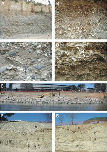
More generally, outcrops and boreholes show that the overbank sandy cover elsewhere observed on the Turin Unit is not preserved. They moreover indicate that these sediments are characterized at the top by a brown colour (7.5 YR 4/4) for a thickness of 1–1.5 m, with local clay coatings on the clasts and a 40 cm thick layer rich of Mn skins (logs 75–77). The lacking of aggregates typical of B-horizon of soils indicates the truncation of the soil with preservation of its C-horizon, suggesting that the Upper Pleistocene soil observed in the proglacial fans at the top of the Turin Unit was partially removed on this terrace (Insert D in the Main Map).
This terrace shows a SSW-NNE elongation (according to the Po River) but lacks of sediments connected to the Po Basin. This discrepancy is explained by erosional phenomena produced by the Po River on the previous outwash sediments of the RAES fans, responsible for the shaping of the T1 as well as the sandy cover erosion and the Upper Pleistocene soil truncation.
3.3.2. Murazzi unit (T2 Terrace)
Another terrace elongated with a SSW-NNE trend (Murazzi Terrace, T2) is developed at a minor level between 227 (BIT Palace) and 226 m (Murazzi) on the left side and between 230 (Boccia d’Oro) and 215 m (Rosa) on the right side, 9–11 m higher on the mean Po level (Main Map). An evident 3–5 m high scarp divides this terrace from the higher T1 (D), only locally smoothed by anthropic reshaping. T2 is laterally continuous with the terraces connected to Sangone and Dora Riparia rivers (Vanchiglia Unit).
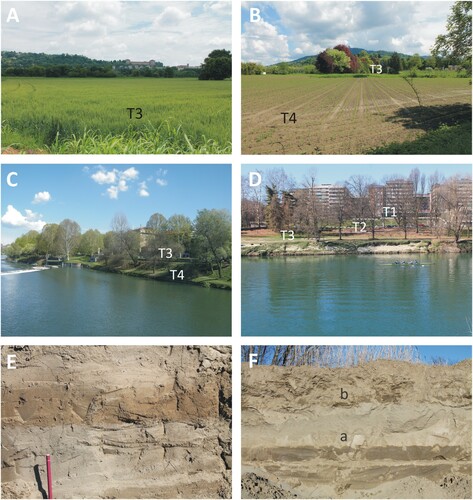
Figure 8. (A) Wide extension of T3 in the Vallere Park, NW of the Moncalieri Castle (visible on background); (B) a significant T3 and T4 succession is preserved in the Meisino Park (the Superga Basilica is visible at the top of the hill); (C) presence of the T3 and T4 succession near the Vittorio Veneto Place along the Po River; (D) detail of T1, T2, and T3 south of the Car Museum; (E) detail of the sand outcropping at the top of T3 on the right bank of the Po River south of the Balbis Bridge; (F) sand (a) at the top of T4 on the right bank of the Po River SW of Moncalieri (MT in the Main Map) covered by 60 tick fine anthropic sediments (b).
A significant temporary outcrop (150 m long and 8 m high) was visible also for this unit during the field survey along the left bank of the Po River 100 m southeast of the Car Museum (CM), where a bank reinforcement was made to consolidate the fluvial scarp subsequent the damage related to the 21–25 November 2016 flood event (E). It shows a lower body consisting of pebbly sand and an overlying body of clast-supported gravel (F), both characterized by evident cross bedding and greyish brown colour (2.5 Y 5/2), with a local cover of brown anthropic sediments (G). Sandy gravel lies on evident erosional surfaces with concave trends referred to fluvial channels incised in the lower sandy body. Clasts consist of rounded pebbles and cobbles up to 15 cm long. The imbricated clasts with b-axis dip N220-260°/10-20° indicate an average flow trending toward NE (from N40° to N80°).
Gravel and sand are not weathered and locally weakly cemented. They show a highly varied petrographic composition that is, also in this case, the same as that of Turin Unit (). The observation of few stratigraphic logs (21–23 in , 97–99 in ) confirms the gravel facies with sand lenses.
The SSW-NNE trend of T2 (according to the Po River trend) and the prevailing lack of fluvial sediments referred to the Po Basin indicate a second erosional terrace, shaped by the Po River in the outwash sediments of the RAES, also implying the erosion of their overbank sandy cover and soil. Nevertheless this terrace, exclusively in the Turin northern sector (outcrop S at Sassi) shows cross bedded sand of grey colour suggesting the local presence of a depositional terrace downstream the confluence with the Dora Riparia and Stura di Lanzo rivers (Main Map).
3.3.3. Vallere unit (T3 Terrace)
Another terrace, indicated as the Vallere Terrace (T3), is preserved on both sides of the Po River between 222 (Vallere Park) (A) and 214 m (Stura Park) in the left side and and between 221 (NE of BIT) and 213 m in the right (Rosa), highly entrenched in the previous terraced succession (Main Map). A 3–4 m high scarp divides this terrace from the T2, particularly evident in the southern sector of Turin. This terrace hangs up to 7 m above the mean Po level (C), but this height is reached due to the addition of large embankment deposits along the urban stretch of this river. Therefore, the natural terrace is only 4–5 m higher than the Po River level as in the Vallere Park.
Some outcrops are visible along both banks of the Po River, although they often appear partly buried by recent silty sand deposited during the 2016 flood event. The top and the scarp of T3 are also widely covered by anthropic deposits, now outcropping along the Po River incision.
The sediments, referred as the Vallere Unit, consist of soft, fine to coarse-grained sand with through cross bedding, of greyish brown colour (2.5 Y 5/2). They locally contain pebbly lenses rich in quartzite clasts and thin lenses of planar-parallel laminated silt (E). A wood fragment collected in a silty sandy core (log 74 in ) at a depth of 6.42 m supplied a radiocarbon age of 328 ± 21 a 14C BP corresponding to a calibrated age of 1445–1522 AD.
The recently specially drilled 26 m-deep piezometer in the Botanic Garden (log 81 in ) at 225 m a.s.l. shows a 18 m thick body of fluvial deposits, consisting of alternating sandy fine gravel and silty sand linked to the Po River, lying on the Pliocene marine sediments (). The clasts forming gravel layers are centimetric to decimetric in size, well rounded with prevalence of elongated clasts and essentially formed by quartzite with presence of anagenite pebbles. A 5.4 m thick sand body with brick fragments, in the upper part of the core, allowed us to recognize thick anthropic deposits covering T3 in this sector. The natural top of the terrace thus occurs at 220 m a.s.l., in accordance with the elevation of T3 (cross section a in the Main Map). Other borehole logs (61, 74, 127 in and ) confirm the alternating fine gravelly, sandy and silty facies of this unit and its thickness comprised from 13 and 21 m.
In addition to the SSW-NNE elongation and slope towards northeast of this terrace, the prevailing sandy facies and petrographic composition (), different from the RAES sediments and instead typical of the Po River, are in accordance with a supply by the current Po Basin. In detail, the contribution from the southern tributaries (Varaita, Maira, Grana and Stura di Demonte rivers) and of the paleo Tanaro River is testified by the anagenite clasts, only deriving from the southwest sector of the Alps (Insert A in the Main Map). These overall features are referred to a typical depositional terrace.
3.3.4. Meisino unit (T4 Terrace)
The last terrace, reported as the Meisino Terrace (T4), is locally distributed in a narrow band along the current Po River. It is a very low terrace hanging about 1 m above the mean Po level and discontinuously preserved on both sides of this watercourse between 219 (Vallere Park) and 208 m (Stura Park) in the left side and between 220 (Moncalieri) and 208 m (Meisino Park) in the right side (Main Map). It forms wide surfaces only south of Moncalieri and downstream of the Dora Riparia-Po confluence where the Meisino Park develops (B).
The sediments, referred as the Meisino Unit, also consist of soft, fine – to coarse-grained sand with evident through cross-bedding, of greyish brown colour (2.5Y 5/2) (F). Also the features of this unit (SSW-NNE elongation, NNE slope, sandy facies, petrographic composition of clasts) are in accordance with a supply by the current Po River, suggesting a later depositional terrace.
3.4. Fluvial sediments connected to the tributary watercourses
The Turin sectors along the tributary watercourses (Sangone, Dora Riparia and Stura di Lanzo rivers), near the confluence with the Po River, consist of the recent alluvial plain entrenched in the RAES sediments. Two units are recognized based on their elevation. The Vanchiglia Unit consists of a low terrace 4–6 m higher than the riverbeds. The Parco Stura Unit comprises all the lower flood plains (Main Map).
These two sectors are evident along the Dora Riparia River, with a wide terrace (232–225 m) on which the Vanchiglia district was built in the XIX century, and a lower plain (229–217 m) on which the main Turin Cemetery lies, both incised for some metres by the current Dora Riparia River. The low elevation of these surfaces gives rise to frequent floods, only partly mitigated through land reclamation. Rare small outcrops of fluvial sediments are visible, that show gravel consisting of pebbles and cobbles with highly various petrographic compositions similar to that of the Turin Unit.
Numerous small lateral fans supplied by hilly watercourses are preserved at the foot of Turin Hill in the right side of the Po River, subsequently incised by the current torrents. Their highest terraced surfaces are grouped in the Valsalice Unit and correlated with the erosional terraces of the Po River (T1 and T2), e.g. south of Monte dei Cappuccini. The lower alluvial plains (e.g. Madonna del Pilone and Sassi Station) are referred as the Sassi Unit and correlated with the depositional terraces of the Po River (T3 and T4). The rare outcrops of fluvial sediments show silty-sandy gravel consisting of cobbles and boulders with various petrographic compositions (essentially metamorphic rocks such as serpentinite, metagabbro, prasinite, eclogite, quartzite and peridotite) mainly connected to the reworking of marine conglomerate outcropping in Turin Hill.
3.5. Anthropic sediments and landforms
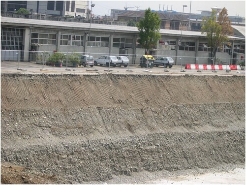
River embankments, bank defences, walking routes (locally named Murazzi) and boarding for the river navigation, combined with the accumulation of large quantities of anthropic deposits, diffusely cover the natural Po terraces. Similar sediments also characterize the setting of other cities (CitationDel Monte et al., 2016; CitationLuberti et al., 2017, Citation2019). Modification of the natural scarps, essentially finalized to level the urban flowing roads, is particularly common (CitationForno & Lucchesi, 2014). Remarkable anthropic interventions significantly changed the original morphology and stratigraphy along the Po River, specially due to the yards for several universal expositions (1884, 1898, 1902, 1911, 1928, 1961), excavation of the big sewer collector on the left bank between the Sangone and the Stura rivers (1890–1910), construction (1816) and subsequent infilling (1931–1935) of the Michelotti Channel on the right bank, between the Vittorio Emanuele I Bridge and the Madonna del Pilone Church, and accumulation of war debris (northern sector of Valentino Park).
The various features of these sediments, which are constantly rich in rubble, are well exposed in numerous outcrops along the Po River banks (F). Large thickness of these materials is shown by some borehole cores, such as the cores of the Molinette Hospital sector (logs 57, 58, 61 in ) that show an anthropic 9–11 m thick cover (cross section c in the Main Map).
4. Conclusion
Although Turin is crossed by a large river (Po River), the most of the town is built on the extended outwash alpine fans linked to its tributaries, i.e. the distal sector of the RAES proglacial plain (referred to the Upper Pleistocene). Only a small sector of the town is built on the fluvial Po terraces located at the NW foot of Turin Hill (referred to the post-LGM, i.e. Lateglacial-Holocene), which clearly cut the proglacial plain.
This research allows us to recognize three steps in the geological evolution of the investigated area: deposition of the RAES proglacial fans (Upper Pleistocene), first flow of the Po River that deepened its bed into the proglacial sediments (Lateglacial-Holocene) and subsequent deposition by the Po River (Holocene).
The Po River assumed the current trend northward at the foot of the hill, likely through an overflow phenomenon to use previous trends of Alpine watercourses (CitationForno et al., 2018). The radiocarbon ages of fluvial sediments south of Turin reported in the previous geological publications (CitationTropeano & Olive, 1989) range from older than 44 to 14.0 ka cal BP for the paleo Po sediments (LGM and Lateglacial) and from 6.8 ka cal BP to a series of historical ages for the neo Po sediments (Holocene) (Table 1 in CitationForno et al., 2018). This framework allowed an approximate dating of the Po River overflow phenomenon from Lateglacial to Holocene.
Considering the new data coming from the geomorphological mapping of the Po terraces, the lack of radiocarbon dating in the range 14.0–6.8 ka BP is in agreement with a stratigraphic gap connected to the erosional phenomena that produced T1 and T2. Moreover, the new radiocarbon age for the Vallere Unit (T3) has supplied another historical age (1445–1522 AD) for the neo Po sediments. Finally, the anthropic interventions take on a significant impact on the urban morphology of Turin. The modification of the Po banks was particularly significant, with the accumulation of anthropogenic deposits covering long stretches of the river terraces and scarps, as reported for other cities (CitationFalkowski et al., 2017).
Software
Map design and graphical production of the map were carried out using Corel Draw 9.0. Figures were drawn and photos were managed and written with the vector graphics editor Corel DRAW 9.0. A graph was made in Microsoft Office Excel 2007.
MAIN_MAP_10Mb.pdf
Download PDF (9.5 MB)Acknowledgment
We are grateful to Rajandrea Sethi of Turin Polytechnic and Giorgio Chiesa of Sondeco S.r.l. for allowing us to examine the cores from the Valentino Park boreholes. The collaboration of the Esseti LTD Company and Maria Todisco of Turin University allowed to observe the Aldo Moro excavation. We are grateful to Laura Turconi, Makram Murad-al-Shaikh and Tomasz Falkowski for the revision and useful suggestions.
Disclosure statement
No potential conflict of interest was reported by the author(s).
Related Research Data
References
- Barbero, D., Boano, P., Colla, M. T., & Forno, M. G. (2007). Pleistocene terraced fluvial succession, northern slope of the Torino Hill. Quaternary International, 171-172, 64–71. https://doi.org/10.1016/j.quaint.2006.12.009
- Biella, G. C., Polino, R., De Franco, R., Rossi, P. M., Clari, P. A., Corsi, A., & Gelati, R. (1997). - The crustal structure of the western Po plain: Reconstruction from the integrated geological and seismic data. Terra Nova, 9(1), 28–31. https://doi.org/10.1046/j.1365-3121.1997.d01-5.x
- Boano, P., Forno, M. G., & Lucchesi, S. (2004). Pleistocene deformation of the Collina di Torino inferred from the modelling of their fluvial succession. Italian Journal of Quaternary Science, 17(2/1), 145–150.
- Bortolami, G. C., Crema, G. C., Malaroda, R., Petrucci, F., Sacchi, R., Sturani, C., … Venzo, S. (1969). Foglio 56 ‘Torino’ della Carta Geologica d’Italia alla scala 1:1000.000, IIa ed. Roma: Servizio Geologico d’Italia.
- Bronk Ramsey, C. (2017). Methods for summarizing radiocarbon datasets. Radiocarbon, 59(2), 1809–1833. https://doi.org/10.1017/RDC.2017.108
- Carraro, F., Collo, G., Forno, M. G., Giardino, M., Maraga, F., Perotto, A., & Tropeano, D. (1995). L’evoluzione del reticolato idrografico del Piemonte centrale in relazione alla mobilità quaternaria. In R. Polino, & R. Sacchi (Eds.), Atti del Convegno Rapporti Alpi-Appennino. Rendiconti Accademia Nazionale delle Scienze, (14, 445–461).
- Castellarin, A. (1994). Strutturazione eo- e meso-alpina dell’Appennino settentrionale attorno al ‘‘nodo ligure’’. Studi Geol. Camerti, vol. spec., CROP 1-1A, 99-108.
- Compagnoni, R., & Forno, M. G. (1992). Significato geologico di depositi fluviali ghiaiosi pleistocenici medi nella Collina di Torino. Italian Journal of Quaternary Science, 5(1), 105–122.
- Del Monte, M., D’Orefice, M., Luberti, G. M., Marini, R., Pica, A., & Vergari, F. (2016). Geomorphological classification of urban landscapes: The case study of Rome (Italy). Journal of Maps, 12(Iss. Sup1), 178–189. https://doi.org/10.1080/17445647.2016.1187977
- Dela Pierre, F., Piana, F., Fioraso, G., Boano, P., Bicchi, E., Forno, M. G., Violanti, D., Clari, P. A., & Polino, R. (2003). Note illustrative della Carta Geologica d'Italia alla scala 1:50.000. Foglio 157 “Trino”. APAT, Roma, 147 p.
- Falkowski, T., Ostrowski, P., Siwicki, P., & Brach, M. (2017). Channel morphology changes and their relationship to valley bottom geology and human interventions; a case study from the Vistula Valley in Warsaw, Poland. Geomorphology, 297, 100–111. https://doi.org/10.1016/j.geomorph.2017.09.011
- Festa, A., Boano, P., Irace, A., Lucchesi, S., Forno, M. G., Dela Pierre, F., Fioraso, G., & Piana, F. (2009). Foglio 156 “Torino Est” della Carta Geologica d'Italia alla scala 1:50.000. APAT, Agenzia per la Protezione dell'Ambiente e per i Servizi Tecnici- Dipartimento Difesa del Suolo, Roma.
- Forno, M. G., Ben, G., Boano, P., Bocca, P., Boero, V., & Compagnoni, R. (2002). Lembi di depositi fluviali provenienti dai bacini alpini nordoccidentali sulla Collina di Torino presso Villa Gualino (NW Italy). Italian Journal of Quaternary Science, 15(2), 175–185.
- Forno, M. G., De Luca, D., Bonasera, M., Bucci, A., Gianotti, F., Lasagna, M., Lucchesi, S., Pelizza, S., Piana, F., & Taddia, G. (2018). Synthesis on the Turin subsoil stratigraphy and hydrogeology (NW Italy). Alpine Mediterranean Quaternary, 31(2), 147–170. https://doi.org/10.26382/AMQ.2018.10
- Forno, M. G., Gattiglio, M., Comina, C., Barbero, D., Bertini, A., Doglione, A., Irace, A., Gianotti, F., Martinetto, E., Mottura, A., & Sala, B. (2015). Stratigraphic and tectonic notes on the Villafranca d’Asti type-area and Castelnuovo Don Bosco sector (Asti Reliefs, Piedmont). Alpine Mediterranean Quaternary, 28(1), 5–27.
- Forno, M. G., & Lucchesi, S. (2005). The fluvial pleistocenic terraced succession of W and NW slopes of the Collina di Torino. Italian Journal of Quaternary Science, 18(2), 123–134.
- Forno, M. G., & Lucchesi, S. (2014). La successione pliocenico-quaternaria su cui è edificata la Città di Torino e il suo significato per l’utilizzo del territorio. Geologia dell'Ambiente, 1(suppl.), 3–10.
- Forno, M. G., & Lucchesi, S. (2016). Relicts of the Pleistocene Po plain on the western and southern slopes of the Turin Hill (NW Italy). Journal of Maps, 12(2), 394–406. https://doi.org/10.1080/17445647.2015.1027481
- Gelati, R., & Gnaccolini, M. (1982). Evoluzione tettonico-sedimentaria della zona limite tra Alpi ed Ap-pennino tra l’inizio dell’Oligocene ed il Miocene medio. Mem. Soc. Geol. It., 24, 183–191.
- Ivy-Ochs, S., Lucchesi, S., Baggio, P., Fioraso, G., Gianotti, F., Monegato, G., Graf, A., Akcar, N., Christl, M., Carraro, F., Forno, M. G., & Schluchter, C. (2018). New geomorphological and chronological constraints for glacial deposits in the Rivoli-Avigliana end-moraine system and the lower Susa Valley (western Alps, NW Italy). Journal of Quaternary Science, 33(5), 550–562. https://doi.org/10.1002/jqs.3034
- Luberti, G. M., Marra, F., & Florindo, F. (2017). A review of the stratigraphy of Rome (Italy) according to geochronologically and paleomagnetically constrained aggradational successions, glacio-eustatic forcing and volcano-tectonic processes. Quaternary International, 438, 40–67. https://doi.org/10.1016/j.quaint.2017.01.044
- Luberti, G. M., Vergari, F., Pica, A., & Del Monte, M. (2019). Estimation of the thickness of anthropogenic deposits in historical urban centres: An interdisciplinary methodology applied to Rome (Italy). The Holocene, 29(1), 158–172. https://doi.org/10.1177/0959683618804630
- Mosca, P., Polino, R., Rogledi, S., & Rossi M. (2010) New data for the kinematic interpretation of the Alps-Apennines junction (Northwestern Italy). Int. J. Earth Sci., 99, 833–849.
- Piana, F., Fioraso, G., Irace, A., Mosca, P., d’Atri, A., Barale, L., Falletti, P., Monegato, G., Morelli, M., Tallone, S., & Vigna, G. B. (2017). Geology of Piemonte region (NW Italy, Alps-Apennines interference zone). Journal of Maps, 13(2), 395–405. https://doi.org/10.1080/17445647.2017.1316218
- Reimer, P. J., Bard, E., Bayliss, A., Beck, J. W., Blackwell, P. G., Ramsey, C. B., Buck, C. E., Cheng, H., Edwards, R. L., Friedrich, M., Grootes, P. M., Guilderson, T. P., Haflidason, H., Hajdas, I., Hatté, C., Heaton, T. J., Hoffmann, D. L., Hogg, A. G., Hughen, K. A., … van der Plicht, J. (2013). Intcal13 and Marine13 radio-carbon age calibration curves 0-50,000 years cal BP. Radiocarbon, 55(4), 1869–1887. https://doi.org/10.2458/azu_js_rc.55.16947
- Salvador, A. (1994). International stratigraphic guide (p. 214), 2nd ed. Geological Society of America.
- Tropeano, D., & Olive, P. (1989). Vitesse de la sédimenta-tion holocène dans la plaine occidentale du Pô (Italie). Bull. Ass. Fran. Ét. Quatern., 26(2), 65–71. https://doi.org/10.3406/quate.1989.1894
- Vezzoli, G., Forno, M. G., Andò, S., Hron, K., Cadoppi, P., Rossello, E., & Tranchero, V. (2009). Tracing the drainage change in the Po basin from provenance of Quaternary sediments (Collina di Torino, Italy). Quaternary International, 30, 1–8. https://doi.org/10.1016/j.quaint.2009.11.009