
ABSTRACT
A 1:60,000 scale geomorphological map of the Argentine side of the northeastern extreme of Isla Grande de Tierra del Fuego in southernmost South America is presented. This paper describes and summarizes the geomorphology of the mapped area, which includes glacial, periglacial, fluvial, coastal, aeolian, lacustrine, and anthropogenic landforms that span over 680 km2 north of San Sebastián Bay in a sparsely populated semiarid and cold steppe used for sheep breeding and hydrocarbon extraction. We used Landsat-8, Sentinel-2, and ALOS-PALSAR satellite products combined with field validation to create the map. Glacial advances and retreats as well as climatic and sea level fluctuations that controlled fluvial systems and coastal dynamics were the main sculptors of the landscape during the Late Cenozoic. Aeolian, lacustrine, and anthropogenic activity were later minor contributors. The presented free, open access, vector geomorphological map is intended to be a supporting tool for multidisciplinary researchers and decision-makers.
1. Introduction
Isla Grande de Tierra del Fuego (IGTdF) is located at the southern extreme of South America (Main Map; ). It is enclosed by the southern Andes Range to the west and south, and surrounded by the Atlantic, Pacific, and Southern Oceans. IGTdF can be divided into two main morphological regions: the Fuegian Andes to the south and west, and the plains to the north (CitationFernández et al., 2018). During the Late Cenozoic, the landscape of IGTdF was intensely modified by several outlet glaciers that flowed down from the Cordillera Darwin ice sheet located in the Fuegian Andes (CitationCaldenius, 1932; CitationNordenskjöld, 1899). At various times, glacial advances extended farther north and east than the mountain range, into the plains, reaching the study area of this paper (CitationCoronato et al., 1999). The related glacio-eustatic-, glacio-isostatic-, and neotectonic-induced relative sea level oscillations left a well-defined mark on coastal landscapes.
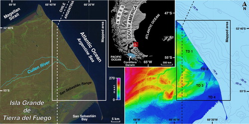
Figure 1. Location of the mapped area over a Landsat-8 true color satellite image (left) and an ALOS-PALSAR DEM HSV shaded map (right). Topographic domains (TDs) and main geographical features are indicated.
This article aims to describe the geomorphology of the Argentine northeastern tip of IGTdF (see Main Map). The mapped area spans 680 km2, a region bounded by the Magellan Strait and the Atlantic Ocean to the north and east, the Argentina–Chile international border to the west, and the Bahía Inútil-Bahía San Sebastián (BI-BSSb) depression to the south. A free, open access, vector geomorphological map of this zone is provided with the hope that it will be a useful tool for multidisciplinary researchers and decision-makers.
2. Natural and socio-economic setting
The mapped area is divided in four topographic domains (TDs; ): To the north, there is an elevated plain (TD 1, 80 m a.s.l. average elevation). The central sector features a wide, low-elevation alluvial plain (Cullen River; TD 2, 20 m a.s.l. average elevation). Pockmarked hills proceed to the south (TD 3, 60 m a.s.l. average elevation), and the San Sebastián Bay depression is located at the southern margin (TD 4). Elevations range from 160 m a.s.l. in the western hills to sea level along the coastal cliffs and the bay, following a gentle slope ().
The climate is sub-humid, cold/temperate with a negative hydrological balance most of the year, except in the snowstorms season in winter. Mean annual precipitation is 324.6 mm and mean annual temperature is 5.5°C (CitationVillarreal & Coronato, 2017). Wind blows persistently throughout the year, mainly from the NW, W, and SW; the mean velocity is 23.7 km/h, reaching up to 152 km/h in gusts (CitationVillarreal & Coronato, 2017). These environmental conditions lead to a semiarid steppe ecosystem featuring xerophyte shrubs and grassland vegetation (CitationCabrera, 1971; CitationCoronato et al., 2008; CitationRoig, 1998).
The Cullen River is the only perennial stream of the study area. Its headwaters are in Chile, about 30 km west of the international boundary, and it discharges into the Atlantic Ocean. Smaller ephemeral and intermittent streams flow along canyons.
The main economic activities in the mapped area are hydrocarbon extraction and sheep breeding. The population is scarce (less than 1000 people) and transient, essentially composed of the workers of oil plants and Cullen Ranch. The nearest city is Río Grande, located 100 km to the southeast.
3. Landscape evolution through the Late Cenozoic
During the Neogene, the mapped area was affected by strike-slip deformation and northwards continental drift. The array of the major tectonic troughs followed a SW-NE trend (CitationDiraison et al., 1997, Citation2000; CitationGhiglione et al., 2013).
Glacial cycles have occurred in southern South America since the Late Miocene (CitationMercer & Sutter, 1982; CitationWenzens, 2006). Glaciations affected northern IGTdF as lobe glaciers fed by the ice sheets located at the southwestern part of the island. These lobes expanded northeastwards, along the tectonic depressions, occupying the piedmont plains and reaching the present-day Atlantic coast () (CitationAuer, 1956; CitationCaldenius, 1932; CitationFeruglio, 1950; CitationNordenskjöld, 1899). The morainic ridges and belts related to the oldest glaciations registered on IGTdF are recognized around the Magellan Strait and the BI-BSSb depression (CitationBentley et al., 2005; CitationClapperton et al., 1995; CitationCoronato et al., 2004; CitationDarvill et al., 2014, Citation2015, Citation2017; CitationGlasser & Jansson, 2008; CitationMeglioli, 1992; CitationRabassa et al., 2011; CitationRutter et al., 2012) ().
Figure 2. Map of ice lobe limits over southern Patagonia and Tierra del Fuego for the Great Patagonian Glaciation (GPG), Post-GPG 1, 2, and 3, and the Last Glacial Maximum (LGM) (based on CitationRabassa et al., 2011). The base layer is a GMTED2010 DEM.
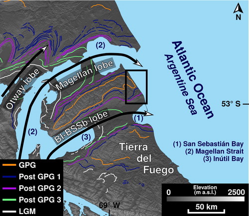
CitationMeglioli (1992) recognized three glacial stratigraphic units in this study area and named them ‘Pampa de Beta’, ‘Río Cullen’, and ‘Sierras de San Sebastián’, that would correspond with the Great Patagonian Glaciation (GPG, ca. 1.1 Ma BP; CitationMercer, 1976), Post-GPG 1 (<1 Ma BP to >760 ka BP; CitationCoronato et al., 2004), and Post-GPG 2 (<760 ka BP to >315 ka BP; CitationCoronato et al., 2004), respectively. CitationDarvill et al. (2015) proposed a much younger chronology based on cosmogenic nuclide dating of associated outwash sediments. The ages of the Río Cullen and Sierras de San Sebastián glaciation would be ca. 45.6 ka BP and ca. 30.1 ka BP, respectively. CitationGriffing (2018) carried out magnetostratigraphic studies on glacigenic sediments, obtaining a chronology that coincides with CitationMeglioli’s (1992) proposal.
Fluvial processes have oscillated during the Late Cenozoic, controlled mainly by climatic and relative sea level changes. Base level changes have caused incision, stream capture, and terrace development (CitationCodignotto & Malumián, 1981).
Relative sea level changes have induced marine transgressions and regressions that are evidenced as fossil marshes, raised shorelines and beach ridges, marine terraces, incised canyons, and cliffs (CitationBujalesky, 2007; CitationCodignotto & Malumián, 1981; CitationDe Muro et al., 2015, Citation2017, Citation2018; CitationIsla et al., 1991; CitationVilas et al., 1999; among others).
The eastern coast of southern South America is considered a stable passive margin (CitationSchellmann & Radtke, 2010). Nevertheless, purely eustatic sea level oscillations could be ruled out due to the neotectonic activity at both the Magellan Strait (CitationBentley & McCulloch, 2005; CitationDe Muro et al., 2017, Citation2018) and the eastern coast of Patagonia (CitationRostami et al., 2000). Deglaciation would have not only produced sea level rise through glacio-eustasy, but also land uplift caused by post-glacial isostatic adjustment (CitationRostami et al., 2000; CitationSchellmann & Radtke, 2010).
The San Sebastián Bay formed in a tectonic depression deepened by glacial erosion that was flooded during the Middle Holocene (CitationBujalesky, 2007). Since then, relative sea level has dropped and coastal progradation developed around the bay margins (CitationVilas et al., 1999).
The present-day macromareal tides (∼11 m) and rough waters cause coastal erosion, while southwards longshore drift has created El Páramo spit (CitationBujalesky, 2007).
Strong winds trigger deflation, generating scattered blowouts that coat significant areas of the landscape. A combination of aeolian-lacustrine processes produced shallow lakes and pans (CitationArche & Vilas, 2001; CitationCodignotto & Malumián, 1981; CitationIsla et al., 1991; CitationVilas et al., 1999; CitationVillarreal & Coronato, 2017).
4. Previous research and mapping
CitationNordenskjöld (1899), CitationCaldenius (1932) and CitationFeruglio (1950) made the first regional approach to an ice limits map for southern South America. CitationMeglioli (1992) proposed a glacial stratigraphic model for the Bahía Inútil-Bahía San Sebastián and Magellan Strait lobes based on field observations, mapping, and sample dating. His map was later adjusted by CitationRabassa et al. (2000, Citation2011), CitationCoronato et al. (2004), CitationGlasser and Jansson (2008), CitationCoronato and Rabassa (2011), CitationRutter et al. (2012), and CitationDarvill et al. (2014, Citation2017). CitationOlivero et al. (2007) supplied the first geological map covering all of IGTdF. CitationCodignotto and Malumián (1981) outlined a geological map of the here studied area.
Coastal morphology was first described by CitationCodignotto (1975, Citation1979) and later revised by CitationBujalesky (1990, Citation2007), CitationIsla et al. (1991), and CitationVilas et al. (1999). CitationIsla and Schnack (1995) and CitationMouzo (2005) mapped submarine features. CitationArche and Vilas (2001) and CitationVillarreal and Coronato (2017) examined aeolian landforms located in the bay environment.
5. Methods
The maps of CitationCodignotto and Malumián (1981), CitationIsla et al. (1991), CitationMeglioli (1992), CitationOlivero et al. (2007), and CitationDarvill et al. (2014) provided a basis for the map presented here.
The mapping process employed Landsat-8 panchromatic band (15 m spatial resolution) and Sentinel-2 visible spectrum bands (10 m spatial resolution) satellite images mounted on a GIS project on QGIS 2.16. An ALOS-PALSAR (12.5 m horizontal spatial resolution) DEM was used as a topographic base. The survey was complemented by detailed validation using high-resolution images from Google EarthTM and Bing MapsTM displayed by the QGIS OpenLayers plugin. All features were manually mapped at a 1:20,000 scale (or finer) to obtain smoother outlines. The polygons of geomorphological units were represented using 70% opacity and the gullies were shaded gray with 10% opacity. The base layer is a hillshade map derived from ALOS-PALSAR data. Elevation points were placed in several positions to aid topography visualization. Bathymetric contours (10 m equidistance) obtained from GEBCO 2019 data were plotted over the sea.
The resulting SVG file was edited and exported as a PDF file in Inkscape 0.91. The map is projected in UTM Zone 19S using a WGS 84 datum. It is designed to be printed on A1 size paper at a scale of 1:60,000. Landforms were revised in the field to verify remote interpretation and to improve descriptions and illustrations. These illustrations are shown as figures in this manuscript and in the online supplemental material.
6. Landform description
6.1. Glacial and periglacial landforms
6.1.1. Hummocky moraines
These landforms appear in the southern sector of the map in two subparallel belts. This unit shows a pockmarked topography with mounds and holes that average 50 m in diameter and 4 m in depth (). These landforms have been assigned a glacial origin and classified as kame and kettle topography or hummocky moraines (CitationDarvill et al., 2014, Citation2017; CitationDíaz Balocchi et al., 2018a; CitationMeglioli, 1992).
Figure 3. Hummocky moraine aspect. Google EarthTM satellite image (a). Appearance of hummocks in the field (b and c).
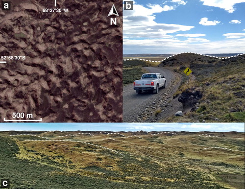
The southernmost hummocky moraine belt (78.5 km2) is a 3 km wide elevated area (30 m over the surrounding relief). It extends SW-NE for 25 km in a smooth curve. It is assigned to the Sierras de San Sebastián glaciation (CitationMeglioli, 1992). The other hummocky moraine belt (33 km2) develops about 4 km to the north and is parallel to the former belt. It is 18 km in length and its width varies from 2.5 km in the west to 0.5 km in the east, where it narrows before reaching the coast. It rises about 20 m over the surrounding relief. This belt is related to the Río Cullen glaciation (CitationMeglioli, 1992). Towards the coast, this moraine is found at a lower level than at inland and its shape is distorted, possibly due to reworking by meltwater coming from the southern belt thaw.
6.1.2. Overridden moraine
In the inner part of the moraine belts, occupying a lower topographic level, there is a flat, or residual hummocky, landscape (). These areas usually show a convex topographic profile and exhibit some inherited subdued landforms like hummocks and minor depressions filled with sediments. This unit is assumed to be an older hummocky moraine overridden by later ice advances. In the northern shore of San Sebastián Bay these moraines are further reworked, probably by aeolian processes and marine ingressions that reached up to 25 m over the present-day sea level during the Middle Pleistocene (CitationBujalesky, 2007).
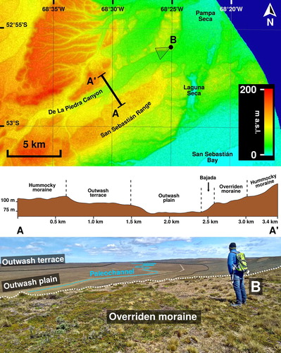
Figure 4. De La Piedra Canyon. Location of the topographic profile and photo over an ALOS-PALSAR DEM HSV shaded map (top). Topographic profile (middle). Field picture of the outwash plain showing a well preserved sinuous paleochannel surrounded by an outwash terrace to the south and an overridden moraine level to the north (bottom).
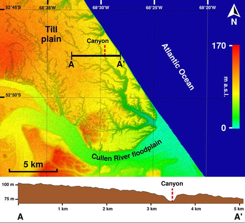
6.1.3. Till plain
North of the Cullen River floodplain, there is a relatively horizontal relief formed by a till cover. It extends over the northern part of the map and is only disrupted by gully incisions (). The surface of this plain is 214 km2, and it is elevated 80 m a.s.l. on average, with a smooth slope (<1°) dipping eastwards. The deposits related to this landform show intercalated strata of till and clast-supported gravels (CitationDíaz Balocchi et al., 2018b) and are linked to the Pampa de Beta glaciation (CitationDíaz Balocchi et al., 2018b; CitationMeglioli, 1992).
Figure 5. Till plain. Location of the topographic profile over an ALOS-PALSAR DEM HSV shaded map (top). Topographic profile (bottom) showing a smooth slope dipping eastwards, only interrupted by a canyon.
6.1.4. Dissected glacigenic tableland
There is a sector of singular topography around Pirámide Canyon. Over a subhorizontal tableland (52 km2) elevated 150 m a.s.l. (and about 25 m over surrounding relief) with a slope of 0.5° dipping eastwards, there is a dense gullies network that shows a subparallel to dendritic pattern with a W-E orientation. The flat surface exhibits coarse sand and gravel with dispersed boulders (up to 1 m in diameter). Outcrops display glacial gravels and diamicts that discordantly cover Neogene rocks. A small part of this unit appears northwards, across the Cullen River floodplain, and is surrounded by the Till plain unit. Considering the appearance, degree of consolidation of its sediments, cross-cutting relationships and elevation, this unit could represent the first pre-GPG glacial surface recognized in Tierra del Fuego, corroborating the ‘Río Grande glaciation’ proposed by CitationMeglioli (1992).
6.1.5. Ice-marginal erosive ridges
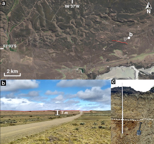
The southwestern study area shows a topography dominated by elongated hills that follow a W-E orientation. This unit (12 km2) is distinguished by narrow (50–80 m wide) and long (up to 900 m) elevations (∼ 5 m) recognized as straight to undulated ridges in aerial photos (). These landforms were sculpted in Neogene sandstones by subglacial and ice-marginal erosive processes, possibly related to the Sierras de San Sebastián glaciation, and could be considered bedrock drumlins. In several locations a thin till cover coats the ridges ().
Figure 6. Elongated subglacial and ice-marginal erosive hills. Google EarthTM satellite image (a). Field view of the hills (b). Reddish Neogene sedimentary rocks covered by pale brown till following an erosive contact (c).
6.1.6. Moraine collapse and subsidence features (depressed hummocky moraine, closed and pitted outwash basins)
Inside the moraine belts, there are several depressed areas. These features appear as elongated basins of smoothed topography that are clearly lower than the surrounding moraine. Over the surface they keep the original hummocky relief or are covered by pitted outwash or lacustrine sediments. Nowadays these depressions can be connected to the drainage network through longitudinal channels or develop closed drainage basins, as in the case of Laguna Salada. These landforms are interpreted as remains of hummocky moraines that were affected by subsidence due to the melting, faulting, and slumping of ice-rich cores of till, or simply due to the thawing of large isolated ice blocks.
6.1.7. Outwash plains and terraces
Between both hummocky moraine belts there are flat topography areas formed by glacial outwash sediments. They are smooth, featureless surfaces of sand and gravel that gently grade away from former ice limits (CitationDarvill et al., 2014) where poorly preserved braided and meandering paleochannels are recognized. These outwash levels were cut by subsequent fluvial erosion, developing terraces and canyons (). The southern moraine belt shows a well-defined meltwater channel that was mapped as a different unit.
Outside the plains, two moraine collapse basins are covered by pitted outwash sediments related to high discharge of meltwater. The thawing of isolated ice blocks shaped depressions that at the present are reworked as aeolian blowouts and ephemeral ponds.
6.1.8. Kettle depressions
Northwards of the San Sebastián hummocky moraine belt there are two depressed units (3 km2) oriented in a N-S direction, dominated by kettle holes. The cavities reach up to 250 m diameter and 10 m depth. Their bottoms are flat and filled with fine-grained sediments, reworked by aeolian, ephemeral fluvial, and lacustrine processes. The units were differentiated because the northernmost one shows signs of strong erosion by meltwater streams.
6.1.9. Thaw slump
In the center of the map there is a spoon-shaped lowland (2.4 km2). This unit is considered a thaw slump limited by a subcircular eroded scarp to the west. In the central sector of the unit, there is a fallen area where hummocks are diminished, tilted, and surrounded by ponds. Eastwards of this surface, there is a region of blurred pushed mounds that form the deposits of the toe of the slump.
6.2. Fluvial landforms
6.2.1. Cullen River channels and floodplain
The Cullen River is found in the central sector of the map. Present-day activity of this fluvial system is restricted to meandering/anastomosing channels and its floodplain (). Tidal influenced lagoons and channels controlled by the longshore drift are located around the estuary that develops on the river mouth.
Figure 7. Cullen River floodplain and terraces. Location of the topographic profile and field photograph over an ALOS-PALSAR DEM HSV shaded map (top). Topographic profile of terraces (middle). View of the Cullen River floodplain and terraces (bottom).
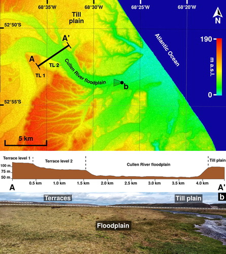
6.2.2. Cullen River terraces
At least three terrace levels are visible on the margins of the current Cullen River floodplain. To the west, two unpaired cut terrace levels are found at 75 and 105 m a.s.l. (). In the eastern sector, at 20 m a.s.l, there is a terrace molded on outwash deposits.
6.2.3. Gullies and canyons
Base level changes have caused the incision of gullies in a great portion of the mapped landscape. The first group of gullies is located over the dissected glacigenic tableland and was described above.
Another group of gullies cut over the Till plain unit, following a SW-NE to NW-SE disposition. They show a subdendritic pattern and highly smoothed slopes (a). These landforms are evidence of ancient fluvial regimes of high erosive power, probably related to deglaciation or rapid base level changes. Some of these gullies developed large canyons of up to 60 m depth. They can reach the coastal cliffs as hanging valleys (e.g. Tortuga Canyon) or the sea level in estuaries (e.g. Beta and Alfa canyons) (b and c).
Figure 8. Field view of old canyons and gullies cutting the till plain. They show smooth and eroded slopes (a) that can reach the coastline as hanging valleys or at sea level (b and c).
6.2.4. Minor ephemeral streams
The mapped area presents minor ephemeral streams that follow an arrangement controlled by structural and morphological features (CitationDíaz Balocchi, 2017). These creeks are usually dry but can conduct temporary discharge during floods or in the snowmelt season. In specific locations (e.g. Pirámide Canyon), the phreatic level reaches the surface, forming intermittent ponds and wet meadows.
6.2.5. Bajada
Inside the De La Piedra Canyon, several alluvial fans laterally coalesce forming a bajada. This unit covers 1.3 km2 and is made of till reworked by colluvial and alluvial processes.
6.3. Coastal landforms
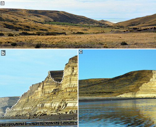
6.3.1. Active cliffs
Active cliffs are found along 40 km in a NNW-SSE orientation, between Espíritu Santo Cape and Nombre Cape. They climb from 10 m up to 90 m height in a northwards direction (CitationBujalesky, 2007). The cliffs are actively retreating with episodic collapse events triggered by extraordinary storm waves and tides (CitationBujalesky, 1990, Citation2007), increased by regular mass-wasting processes over unstable slopes.
6.3.2. Paleocliffs
A paleocliff is recognized in the southern portion of the study area, surrounding San Sebastián Bay (CitationCodignotto & Malumián, 1981). It is about 4 m high and 20 km long, along a WSW-ENE direction. Another paleocliff (40 m high) was identified immediately northwards, following a SSW-NNE orientation.
6.3.3. Beaches
A series of sandy beaches are positioned in a thin strip between the active cliffs and the coastline in most of the eastern part of the study area. These beaches are affected by macromareal tides and strong waves that develop a southwards longshore drift (CitationCodignotto & Malumián, 1981; CitationIsla et al., 1991). The beaches are wider north of the Cullen River (about 200 m); while in the south they reach a maximum width of 100 m. The beaches surrounding El Páramo Peninsula will be described below.
6.3.4. Estuaries
The river mouths of the Cullen River and the streams at Alfa and Beta canyons are reworked by macromareal tides and wave action. These small wave-dominated estuaries display barrier beaches, lagoons and inlets controlled by the southwards longshore drift. The Cullen River estuary also presents some tidal channels that are active in flood tides produced by severe storms.
6.3.5. Supratidal flat (and marshes)
A supratidal flat surrounds the San Sebastián Bay. This unit is a 3 km-wide, 42 km2 semicircular belt not influenced by ordinary tides. It features a plain topography with a smooth (<0.1°) slope dipping to the south and east. The sediments composing this unit are fine silt and pore salts highly susceptible to erosion. The main landforms are shallow (<1 m) ponds and lagoons of hydro-aeolian erosion origin (CitationBujalesky, 2007; CitationIsla et al., 1991; CitationVillarreal & Coronato, 2017).
6.3.6. Intertidal flat (muddy/mixed)
Inwards the bay, the action of macromareal tides produced an intertidal flat (34 km2) that displays a dendritic to subparallel tidal channel network. These channels have meandering to straight patterns and reach depths of over 3 m and widths of over 50 m (CitationBujalesky, 2007). The tidal currents transport sediment in a clockwise direction with grain-size increasing southwards due to wave action (CitationBujalesky, 2007; CitationIsla et al., 1991).
6.3.7. Gravel spit
El Páramo Peninsula is a 20 km long gravel spit formed by southwards longshore drift (CitationCodignotto, 1975). Its width oscillates between 200 and 1200 m (CitationKokot, 2010). The northern sector (sensu CitationIsla et al., 1991) is included in the here presented map. It is composed of gravel beach ridges parallel to the paleocliff in the northernmost part that progressively turn to a N-S orientation as one moves southwards (CitationBujalesky, 1990). Gravels are the main constituents of the spit, although a sandy matrix is always present (CitationIsla et al., 1991). The Atlantic beach is 100 m wide, while the bay beach is steeper and only 50 m wide (CitationBujalesky, 1990).
6.4. Aeolian and lacustrine landforms
This unit is not differentiated on the map because either: (1) it overlaps other units that have a stronger influence on the landscape, or (2) its small-sized landforms cannot be clearly displayed at the chosen scale.
6.4.1. Erosional landforms
They are recognized as blowouts and minor water bodies. Wind activity reworks marsh and supratidal sediments producing muddy lunettes that surround shallow, W-E elongated, ponds (up to 4 km long) (CitationArche & Vilas, 2001; CitationVillarreal & Coronato, 2017).
Northwards, small blowouts (up to 300 m in diameter) coat most of the surface. Current aeolian and ephemeral lacustrine processes modify preexistent depressions of glacial or aeolian origin.
6.4.2. Isolated climbing dunes
Isolated dunes formed by coarse sand and fine pebbles partially climb along coastal cliffs, at the eastern sector of the study area, mainly between Alfa and Tortuga canyons. These very elongated barchans to linear dunes advance in a NNE-SSW direction, parallel to the coast, and are fed by beach deposits.
6.5. Anthropogenic landforms
Roads and oil well pads are the main human landforms. Some feedlots show denudation and incipient soil erosion caused by sheep. Structures built on oil plants, ranches, and small settlements complete this unit.
7. Conclusions
A geomorphological map at a 1:60,000 scale of the northeastern extreme of Isla Grande de Tierra del Fuego, Argentina, was produced. Interpretation of satellite images and field recognition were used to identify glacial, periglacial, fluvial, coastal, aeolian, lacustrine, and anthropogenic landforms. A simplified landscape evolution of the study area during the Late Cenozoic is suggested following these stages:
Neogene N-S tectonic extension shaped eastwards and northeastwards oriented troughs (e.g. proto-Magellan Strait).
Structurally controlled drainage developed over the main faults (e.g. proto-Cullen River).
During the Early Pleistocene (and presumably earlier) piedmont glaciers formed massive glacial tablelands (e.g. Pampa de Beta).
Deglaciation led to the flow of large, highly erosive rivers. Also, land uplift might have aided the incision of canyons and terraces, as well as the formation of the paleocliffs.
The glacial advances of the BI-BSSb ice lobe during the Middle Pleistocene further dug the valley. The Río Cullen and Sierras de San Sebastián moraines indicate the limits of each advance. Ice-marginal erosive features were chiseled over the bedrock in the southern zone.
Final ice degradation combined with periglacial, fluvial, and mass-wasting processes remodeled previous glacial landforms. Abundant meltwater produced proglacial outwash plains. Multi-causal land uplift restarted the formation of terraces. Aeolian erosion reshaped glacigenic depressions as blowouts.
During the Middle Holocene transgression, the San Sebastián Bay was flooded. Southwards longshore drift shaped El Páramo spit.
Software
The map was generated using QGIS 2.16. Final edition and PDF export were performed using Inkscape 0.9.
Acknowledgements
We thank Total Austral S.A. for their support with accommodation. Estancia Cullen allowed us to use their private roads. Cristina San Martín, Candela Gorza, Ramiro López and Mauro Gómez Samus helped us during fieldwork. We are very grateful to Matteo Spagnolo, Chris Orton, and Sandro De Muro for their reviews and suggestions. Finally, we thank Dante Francomano and Ryne Flanagan for the revision of English language.
Disclosure statement
No potential conflict of interest was reported by the author(s).
Additional information
Funding
Related Research Data
References
- Arche, A., & Vilas, F. (2001). Sedimentos eólicos de grano fino en la Bahía de San Sebastián, Tierra del Fuego, Argentina. Journal of Iberian Geology, 27, 159–173.
- Auer, V. (1956). The Pleistocene of Fuego-Patagonia. Part I: The ice and interglacial ages. Annales Academia Scientiarum Fennicae, A, III, 45, 1–222.
- Bentley, M. J., & McCulloch, R. D. (2005). Impact of neotectonics on the record of glacier and sea level fluctuations, Strait of Magellan, southern Chile. Geografiska Annaler: Series A, Physical Geography, 87(2), 393–402. https://doi.org/10.1111/j.0435-3676.2005.00265.x
- Bentley, M. J., Sugden, D. E., Hulton, N. R., & McCulloch, R. D. (2005). The landforms and pattern of deglaciation in the Strait of Magellan and Bahía Inútil, southernmost South America. Geografiska Annaler: Series A, Physical Geography, 87(2), 313–333. https://doi.org/10.1111/j.0435-3676.2005.00261.x
- Bujalesky, G. G. (1990). Morfología y dinámica de la sedimentación costera en la península El Páramo, Bahía San Sebastián, Isla Grande de la Tierra del Fuego [Unpublished doctoral dissertation]. Facultad de Ciencias Naturales y Museo, Universidad Nacional de La Plata.
- Bujalesky, G. G. (2007). Coastal geomorphology and evolution of Tierra del Fuego (Southern Argentina). Geologica Acta, 5(4), 337–362. https://doi.org/10.1344/105.000000294
- Cabrera, A. L. (1971). Fitogeografía de la República Argentina. Boletín de la Sociedad Argentina de Botánica, 14, 1–42.
- Caldenius, C. (1932). Las Glaciaciones Cuaternarias en la Patagonia y Tierra del Fuego. Geografiska Annaler, 14, 1–164. https://doi.org/10.1080/20014422.1932.11880545
- Clapperton, C. M., Sugden, D. E., Kaufman, D. S., & McCulloch, R. D. (1995). The last glaciation in central Magellan Strait, southernmost Chile. Quaternary Research, 44(2), 133–148. https://doi.org/10.1006/qres.1995.1058
- Codignotto, J. O. (1975). Geología y Rasgos Geomorfológicos de la Patagonia Austral Extraandina, entre el río Chico de Gallegos (Santa Cruz) y la bahía de San Sebastián (Tierra del Fuego) [Unpublished doctoral dissertation]. Facultad de Ciencias Exactas y Naturales, Universidad de Buenos Aires.
- Codignotto, J. O. (1979). Hojas Geológicas 63a Cullen, 64a Bahía San Sebastián y 65b Río Grande. Servicio Geológico Nacional.
- Codignotto, J. O., & Malumián, N. (1981). Geología de la región al norte del paralelo 54 S de la Isla Grande de Tierra del Fuego. Revista de la Asociación Geológica Argentina, 36(1), 44–88.
- Coronato, A., Coronato, F., Mazzoni, E., & Vázquez, M. (2008). The physical geography of Patagonia and Tierra del Fuego. In J. Rabassa (Ed.), The Late Cenozoic of Patagonia and Tierra del Fuego (pp. 13–55). Elsevier. https://doi.org/10.1016/S1571-0866(07)10003-8
- Coronato, A., Meglioli, A., & Rabassa, J. (2004). Glaciations in the Magellan Straits and Tierra del Fuego, southernmost South America. In J. Ehlers & P. L. Gibbard (Eds.), Quaternary glaciations extent and chronology part III: South America, Asia, Africa, Australasia, Antarctica (pp. 45–48). Elsevier. https://doi.org/10.1016/S1571-0866(04)80110-6
- Coronato, A., & Rabassa, J. (2011). Pleistocene glaciations in Southern Patagonia and Tierra del Fuego. In J. Ehlers, P. L. Gibbard, & P. D. Hughes (Eds.), Quaternary glaciations – extent and chronology: A closer look (pp. 715–727). Elsevier. https://doi.org/10.1016/B978-0-444-53447-7.00051-9
- Coronato, A., Salemme, M., & Rabassa, J. (1999). Palaeoenvironmental conditions during the early peopling of southernmost South America (Late Glacial-Early Holocene, 14-8 ka BP). Quaternary International, 53-54, 77–92. https://doi.org/10.1016/S1040-6182(98)00009-3
- Darvill, C. M., Bentley, M. J., Stokes, C. R., Hein, A. S., & Rodés, Á. (2015). Extensive MIS 3 glaciation in southernmost Patagonia revealed by cosmogenic nuclide dating of outwash sediments. Earth and Planetary Science Letters, 429, 157–169. https://doi.org/10.1016/j.epsl.2015.07.030
- Darvill, C. M., Stokes, C. R., Bentley, M. J., Evans, D. J., & Lovell, H. (2017). Dynamics of former ice lobes of the southernmost Patagonian Ice Sheet based on a glacial landsystems approach. Journal of Quaternary Science, 32(6), 857–876. https://doi.org/10.1002/jqs.2890
- Darvill, C. M., Stokes, C. R., Bentley, M. J., & Lovell, H. (2014). A glacial geomorphological map of the southernmost ice lobes of Patagonia: The Bahía Inútil–San Sebastián, Magellan, Otway, Skyring and Río Gallegos lobes. Journal of Maps, 10(3), 500–520. https://doi.org/10.1080/17445647.2014.890134
- De Muro, S., Brambati, A., Tecchiato, S., Porta, M., & Ibba, A. (2017). Geomorphology of marine and transitional terraces and raised shorelines between Punta Paulo and Porvenir, Tierra del Fuego, Straits of Magellan – Chile. Journal of Maps, 13(2), 311–321. https://doi.org/10.1080/17445647.2017.1295406
- De Muro, S., Di Grande, A., Brambati, A., & Ibba, A. (2015). Geomorphology map of the marine and transitional terraces and raised shorelines of the Península Juan Mazía, Tierra Del Fuego. Straits of Magellan – Chile. Journal of Maps, 11(5), 698–710. https://doi.org/10.1080/17445647.2014.970592
- De Muro, S., Tecchiato, S., Porta, M., Buosi, C., & Ibba, A. (2018). Geomorphology of marine and glacio-lacustrine terraces and raised shorelines in the northern sector of Península Brunswick, Patagonia, Straits of Magellan, Chile. Journal of Maps, 14(2), 135–143. https://doi.org/10.1080/17445647.2018.1441759
- Díaz Balocchi, L. (2017, August). Implicancias geomorfológicas y estructurales en el control del drenaje superficial al norte de la Bahía San Sebastián, Isla Grande de Tierra del Fuego. In Asociación Geológica Argentina (Ed.), Proceedings of the 20th Argentine geological congress (symposium 7) (pp. 38 –42). Asociación Geológica Argentina.
- Díaz Balocchi, L., Ponce, J. F., Tripaldi, A., & Magneres, I. (2018a, September). Asociaciones de geoformas y depósitos del sector norte del lóbulo Bahía Inútil – Bahía San Sebastián, Tierra del Fuego. In Bouza, P., Veiga, G., Piovano, E., Zárate, M., & Bilmes, A. (Eds.), Proceedings of the 7th Argentinian Congress on Quaternary and Geomorphology (pp. 206–207). Asociación Argentina de Cuaternario y Geomorfología.
- Díaz Balocchi, L., Ponce, J. F., Tripaldi, A., & Magneres, I. (2018b, September). Caracterización geomorfológica y sedimentológica de la planicie glacigénica del extremo norte del sector argentino de la Isla Grande de Tierra del Fuego. In Bouza, P., Veiga, G., Piovano, E., Zárate, M., & Bilmes, A. (Eds.) Proceedings of the 7th Argentinian congress on quaternary and geomorphology (pp. 208–209). Asociación Argentina de Cuaternario y Geomorfología.
- Diraison, M., Cobbold, P. R., Gapais, D., & Rossello, E. A. (1997). Magellan Strait: Part of a Neogene rift system. Geology, 25(8), 703–706. https://doi.org/10.1130/0091-7613(1997)025<0703:MSPOAN>2.3.CO;2
- Diraison, M., Cobbold, P. R., Gapais, D., Rossello, E. A., & Le Corre, C. (2000). Cenozoic crustal thickening, wrenching and rifting in the foothills of the southernmost Andes. Tectonophysics, 316(1-2), 91–119. https://doi.org/10.1016/S0040-1951(99)00255-3
- Fernández, M., Ponce, J. F., Zangrando, F. J., Borromei, A. M., Musotto, L. L., Alunni, D., & Vázquez, M. (2018). Relationships between terrestrial animal exploitation, marine hunter-gatherers and palaeoenvironmental conditions during the Middle-Late Holocene in the Beagle Channel region (Tierra del Fuego). Quaternary International. Advance online publication. https://doi.org/10.1016/j.quaint.2018.05.032
- Feruglio, E. (1950). Descripción Geológica de la Patagonia: Vol. 3. Dirección General de Yacimientos Petrolíferos Fiscales.
- Ghiglione, M. C., Navarrete-Rodríguez, A. T., González Guillot, M., & Bujalesky, G. (2013). The opening of the Magellan Strait and its geodynamic implications. Terra Nova, 25(1), 13–20. https://doi.org/10.1111/j.1365-3121.2012.01090.x
- Glasser, N., & Jansson, K. (2008). The glacial map of Southern South America. Journal of Maps, 4(1), 175–196. https://doi.org/10.4113/jom.2008.1020
- Griffing, C. Y. (2018). Late Cenozoic glaciations and environments in southernmost Patagonia [Doctoral dissertation]. Simon Fraser University. https://summit.sfu.ca/item/17942
- Isla, F. I., & Schnack, E. (1995). Submerged moraines offshore northern Tierra del Fuego, Argentina. Quaternary of South America and Antarctic Peninsula, 9, 205–222.
- Isla, F. I., Vilas, F. E., Bujalesky, G. G., Ferrero, M., Bonorino, G. G., & Miralles, A. A. (1991). Gravel drift and wind effects on the macrotidal San Sebastian Bay, Tierra del Fuego, Argentina. Marine Geology, 97(1-2), 211–224. https://doi.org/10.1016/0025-3227(91)90027-2
- Kokot, R. R. (2010). Espigas indicadoras de proveniencia de olas en la costa Argentina. Revista de la Asociación Geológica Argentina, 67(1), 19–26.
- Meglioli, A. (1992). Glacial geology and chronology of southernmost Patagonia and Tierra del Fuego [Unpublished doctoral dissertation]. Lehigh University.
- Mercer, J. H. (1976). Glacial history of southernmost South America. Quaternary Research, 6(2), 125–166. https://doi.org/10.1016/0033-5894(76)90047-8
- Mercer, J. H., & Sutter, J. F. (1982). Late miocene—earliest pliocene glaciation in southern Argentina: Implications for global ice-sheet history. Palaeogeography, Palaeoclimatology, Palaeoecology, 38(3-4), 185–206. https://doi.org/10.1016/0031-0182(82)90003-7
- Mouzo, F. (2005). Límites de las glaciaciones Plio-Pleistocenas en la plataforma continental al noreste de la Tierra del Fuego. In Asociación Geológica Argentina (Ed.), Proceedings of the 16th Argentine Geological Congress (pp. 787–792 ). Asociación Geológica Argentina.
- Nordenskjöld, O. (1899). Geologie, geographie und anthropologie. Scwedischen Expedition nach den Magellansländern. Norstedt and Soner.
- Olivero, E. B., Malumián, N., & Martinioni, D. R. (2007). Mapa Geológico de la Isla Grande de Tierra del Fuego e Isla de los Estados a escala 1:400.000. Servicio Geológico Minero Argentino (SEGEMAR).
- Rabassa, J., Coronato, A., Bujalesky, G., Salemme, M., Roig, C., Meglioli, A., Heusser, C., Gordillo, S., Roig, F., Borromei, A., & Quattrocchio, M. (2000). Quaternary of Tierra del Fuego, southernmost South America: An updated review. Quaternary International, 68-71, 217–240. https://doi.org/10.1016/S1040-6182(00)00046-X
- Rabassa, J., Coronato, A., & Martinez, O. (2011). Late Cenozoic glaciations in Patagonia and Tierra del Fuego: An updated review. Biological Journal of the Linnean Society, 103(2), 316–335. https://doi.org/10.1111/j.1095-8312.2011.01681.x
- Roig, F. (1998). La Vegetación de la Patagonia. In M. N. Correa (Ed.), Flora Patagónica (Vol. 8, pp. 48–174). INTA.
- Rostami, K., Peltier, W. R., & Mangini, A. (2000). Quaternary marine terraces, sea-level changes and uplift history of Patagonia, Argentina: Comparisons with predictions of the ICE-4G (VM2) model of the global process of glacial isostatic adjustment. Quaternary Science Reviews, 19(14-15), 1495–1525. https://doi.org/10.1016/S0277-3791(00)00075-5
- Rutter, N., Coronato, A., Helmens, K., Rabassa, J., & Zárate, M. (2012). The glacial and loess record of Southern South America. In N. Rutter, A. Coronato, K. Helmens, J. Rabassa, & M. Zárate (Eds.), Glaciations in North and South America from the Miocene to the last glacial maximum (pp. 1–23). Springer. https://doi.org/10.1007/978-94-007-4399-1_1
- Schellmann, G., & Radtke, U. (2010). Timing and magnitude of Holocene sea-level changes along the middle and south Patagonian Atlantic coast derived from beach ridge systems, littoral terraces and valley-mouth terraces. Earth-Science Reviews, 103(1-2), 1–30. https://doi.org/10.1016/j.earscirev.2010.06.003
- Vilas, F., Arche, A., Ferrero, M., & Isla, F. (1999). Subantarctic macrotidal flats, cheniers and beaches in San Sebastián Bay, Tierra del Fuego, Argentina. Marine Geology, 160(3-4), 301–326. https://doi.org/10.1016/S0025-3227(99)00021-3
- Villarreal, M. L., & Coronato, A. (2017). Characteristics and nature of pans in the semi-arid temperate/cold steppe of Tierra del Fuego. In J. Rabassa (Ed.), Advances in geomorphology and quaternary studies in Argentina (pp. 203–224). Springer. https://doi.org/10.1007/978-3-319-54371-0_8
- Wenzens, G. (2006). Terminal moraines, outwash plains, and lake terraces in the vicinity of Lago Cardiel (49°S; Patagonia, Argentina)—evidence for Miocene Andean foreland glaciations. Arctic, Antarctic, and Alpine Research, 38(2), 276–291. https://doi.org/10.1657/1523-0430(2006)38[276:TMOPAL]2.0.CO;2