
ABSTRACT
The map is aimed at illustrating the relationships between landscape evolution and human occupation in the Isernia basin since the Middle Pleistocene. We carried out a detail scale geological–geomorphological investigation integrated with archaeological data. Overall data suggest enhanced landscape modification related to the long-term evolution of the Isernia basin. Moreover, during the Middle Pleistocene an alluvial plain environment was present, as testified also by the famous Lower Palaeolithic site of Isernia La Pineta dated to ca. 600 ky. From 600 ky onwards, extensional tectonics and related valley incision reshaped the Isernia basin, with the formation of terraced surfaces and the deposition of a travertine plateau. Archaeological findings from the Lower Palaeolithic up to the Chalcolithic Age testify to pre- and protohistoric settlements on these surfaces. In historical times, Romans settled on the Isernia terrace ridge taking advantage of the outcropping travertines to support wall foundations and to extract construction material.
1. Introduction
In the last decades, great interest has been addressed to the study of the interaction between environmental processes and human occupation (CitationBridgland, 2000; CitationBurrough, 2016; CitationFoerster et al., 2015; CitationHoelzmann et al., 2001). Central-southern Italy represents an open-air laboratory to investigate this topic because of its highly dynamic landscape and associated human frequentation since Prehistoric times (CitationAscione et al., 2020; CitationBini et al., 2013; CitationBrandolini et al., 2019; CitationDi Donato et al., 2018; CitationGiaccio et al., 2017; CitationGioia et al., 2019, Citation2020; CitationRusso Ermolli et al., 2014). Even though studies of this kind have investigated a large part of central-southern Italy, only few researches have been carried out in the Molise region (CitationAmato et al., 2013; CitationRosskopf et al., 2006) and, particularly, in the area of Isernia (CitationAmato et al., 2016).
The town of Isernia is located in the western sector of Molise region (i.e. in the so-called Isernia intermontane basin) on top of a narrow river terrace stair, which is limited, towards NW and SE respectively, by the Sordo and Carpino stream valleys, minor left tributaries of the Volturno River. The area of Isernia has experienced human frequentation since prehistoric times as documented by the famous Lower Palaeolithic site of Isernia La Pineta (dated to 583–561 ky; CitationPeretto et al., 2015), which represents one of the most ancient archaeological sites in Europe (CitationPeretto et al., 2015; CitationShao et al., 2011 and references therein). Apart from the Isernia La Pineta site, evidence of prehistoric human presence and occupation of the Isernia area is rather scarce. In fact, most of the archaeological finds date to the Roman and Medieval periods and are concentrated in the modern urban centre and in the peri-urban areas of Isernia (CitationAmato et al., 2016; CitationTesta, 2018; CitationValente & Cozzolino, 2019 and references therein).
The Roman town of Aesernia fell in an area of relevant Roman road junctions, allowing its strong connection with the towns of Aufidena to the north, Bovianum and Beneventum to the south-east and Venafrum to the south-west (CitationAmato et al., 2016 and reference therein). Isernia was located also near historical transhumance routes such as the Roman road Sulmo-Aequum Tuticum (CitationDe Benedittis, 2010) and the drove road Royal Tratturo Pescasseroli-Calenda (CitationDe Benedittis, 2010; CitationSarno, 2014). From Roman times onwards, the town of Isernia expanded from its current historic centre by including several peri-urban areas until reaching its present size. This enlargement was driven by settlement and urban development strategies that are still unclear (i.e. it has not been defined up to now if landscape modifications due to natural events and/or anthropic impact have conditioned the choice of new settlement areas leading to prefer some over others). In addition, it is still unclear why the Roman town was founded so far from the Lower Palaeolithic site of Isernia La Pineta.
To shed light on these points, we carried out an integrated geological, geomorphological and archaeological investigation of the Isernia area trying to unravel the relationships between landscape evolution and human occupation of the territory. As a result, we have derived a geological and geomorphological map of the Isernia area including all available information on archaeological findings (Main map) and produced several sketches showing landscape evolution since the Lower Palaeolithic and the timing of human occupation during historical times.
2. Main features of the Isernia territory
2.1. Geological and geomorphological background
The town of Isernia is located in the so-called Isernia intermontane basin, which is part of the upper Volturno River valley morphostructural depression (CitationAmato et al., 2017; CitationBrancaccio et al., 2000) (). The mountains bordering the Isernia basin rise up to 1000 m a.s.l. and consist of Meso-Cenozoic carbonate successions and Upper Cretaceous to Upper Miocene flysch deposits. The carbonate bedrock consists of centimetric to decimetric layers of limestone, locally with cherty nodules and layers, and interbedded centimetric layers of marls and pelites. Flysch units are made of greyish-greenish silty clays, with frequent decimetric thick layers of quartz-rich sandstone, and mica-rich sandstones.
Figure 1. Schematic geological map of the Molise sector of the central-southern Apennines. The red box indicates the location of the investigated area.
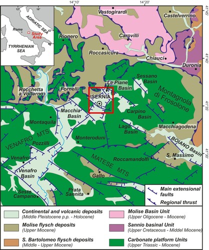
The actual morphotectonic setting of the Isernia area results from a complex tectonic history that started in the Pliocene to Lower Pleistocene time span with regional-scale uplift that was accompanied, along the western Tyrrhenian flank of the chain, by extensional tectonics under a NW–SE sense of extension (CitationCasciello et al., 2006; CitationCinque et al., 1993). Most of the high-angle faults that affect the Isernia basin were formed during the Lower Pleistocene with fault kinematics varying from extensional (on NE–SW faults) to transtensive (on NNE–SSW, E–W and ca. NW–SE faults), and controlled the first phases of the basin formation (CitationAmato et al., 2011, Citation2017, Citation2018). A new tectonic regime established during the Middle Pleistocene, when regional-scale uplift ceased and extensional tectonics acted under a NE–SW sense of extension affecting also the axial belt of the chain (CitationHippolyte et al., 1994; CitationMontone et al., 1999). In this period, most of the transtensive NW–SE trending high-angle faults were reactivated with normal kinematics leading to the actual morphostructural setting of the Isernia basin and influencing the facies distribution of its Quaternary filling.
From Lower Pleistocene onwards, the Isernia basin was filled by a ∼100 m thick sequence of lacustrine, fluvial-marshy and travertine deposits (CitationAmato et al., 2011; Citation2017; CitationAucelli et al., 2011; CitationBrancaccio et al., 1997, Citation2000, CitationColtorti & Cremaschi, 1982). Literature and unpublished borehole data allowed to detail the sedimentary filling of the basin as follows (from bottom to top):
– lacustrine-palustrine and fluvial-marshy deposits (unit U5 after CitationCremaschi, 1983), consisting of clays with thin layers of matrix-supported gravels (Lower-Middle Pleistocene);
– travertine deposits (U4 after CitationCremaschi, 1983), made of an alternation of stromatolithic, phytohermal, phytoclastic travertines and calcareous sands, locally marked by thick dark brown paleosols and light grey clays of lacustrine origin (late Lower Pleistocene and Middle Pleistocene);
– fluvial-marshy deposits (U3 after CitationCremaschi, 1983), consisting of an alternation of thin layers of clays, silty sands, gravelly sands, gravels, phytoclastic travertines and calcareous sands layers with intercalated paleosols, tephra and two main zoo-archaeological layers referred to the Lower Palaeolithic (Middle Pleistocene);
– fluvial deposits and paleosols (U2 after CitationCremaschi, 1983), made of alternating thin layers of fluvial sands and gravels covered by a marked paleosol (Middle Pleistocene);
– fluvial and fluvial-marshy deposits, consisting of alternating layers of rounded openwork and matrix-supported gravels, silty sands and silty clays layers with local intercalations of paleosols and reworked tephra layers dated to 499 ± 13 ka (Middle Pleistocene) (CitationColtorti et al., 2005; CitationPeretto et al., 2015);
– fluvial and fluvial-marshy deposits, made of alternating silty clays, very rich in organic matter and malacological remains, sandy gravels and gravel layers with local intercalations of paleosols (late Middle Pleistocene-Holocene).
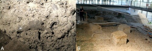
Figure 2. The Isernia La Pineta archaeosite. (A) The main archaeosurface covered with fossils of mammals; (B) view of the archaeological site with remnants of the stratigraphic layers (box-like islets).
The sedimentary facies of the Quaternary filling of the Isernia basin suggest enhanced landscape evolution since the Middle Pleistocene, mostly related to fault activity and river downcutting that caused the formation of large remnants of river terraces and paleosurfaces.
The town of Isernia is located on top of a narrow NE–SW elongated terrace stair mainly set on a wide travertine plate. This terrace is bordered to the north-west and to the south-east, respectively, by two deep, locally gorged incisions drained by the Sordo and Carpino streams that feed into the Cavaliere River, which is a left tributary of the Volturno River. Towards the north-east, the terrace stair is limited by a ∼5 m high scarp that separates it from the Isernia Le Piane basin, a morphostructural depression affected by marshy-palustrine sedimentation also during part of the Holocene (CitationAmato et al., 2017).
Southeastwards and northwestwards of the Isernia terrace stair, the landscape is dominated by several gentle and planar surfaces, which include both erosional surfaces of complex origin sculpted in the carbonate bedrock and erosional and depositional fluvial terraces underlain by Quaternary lacustrine to fluvial deposits.
2.2. The timing of human occupation
The most ancient traces of human frequentation/occupation in the Isernia area date back to the Lower Palaeolithic period, and refer to both the Isernia La Pineta site () and flint artefacts found in various localities around Isernia. Especially on the terrace surfaces surrounding the Isernia ridge, human frequentation was widespread as testified by the occurrence of Palaeolithic, Neolithic and Chalcolithic findings (CitationPeretto et al., 2015; CitationSanchez, 2018; Paglione, December 2019, personal communication).
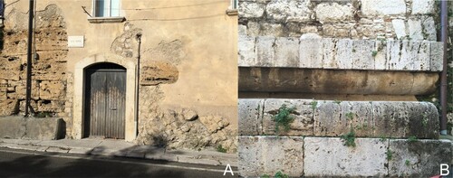
The area of Isernia became a more stable settlement only with the foundation of the Roman colony in 263 BCE, when travertine deposits were used to erect both the buildings of the town and the wall circuit that delimit it (). After the fall of Bovianum in 89 BCE, Aesernia became the capital of the insurgents during the social war, then, in 80 BCE, was destroyed by Sulla.
Figure 3. Remnants of Roman buildings in the urban centre of Isernia. (A) detail of the Roman wall circuit made of polygonal travertine blocks (to the left) resting on the Matese-Frosolone Unit dipping towards south (to the right); (B) detail of the podium in travertine of the Republican temple (major temple, III BCE) on which the cathedral has been erected.
During the Augustan reorganization of Italy, Aesernia was included in the IV Regio Sabina et Samnium ( CitationTerzani, 1991) and became a Roman municipium in the middle of the I century CE (CitationD'Henry, 1989). After the Roman Empire, in the IV century CE, Isernia became part of a major Roman artery, the road Sulmo-Aequum Tuticum (CitationDe Benedittis, 2010) that connected Aufidena with Aequum Tuticum.
In the High Middle Ages, precisely in 1142 CE, Isernia was included in the Norman de Mulisio County. In 1223, after several destructive natural events and numerous barbarian invasions, Federico II ordered the dismantling of the circuit wall, an intervention that profoundly changed the urban layout of the city. From the sixteenth to the eighteenth century, the city of Isernia was a fief for two short periods from 1519 to 1521 and from 1643 to 1744 respectively (Galanti, Citation1781).
The history of Isernia is a sequence of repeated damaging, destruction and reconstruction. From Roman times to the present, the town of Isernia has been subject to numerous disaster events and diseases, especially earthquakes, barbarian invasions, epidemics and wars, which have caused repeated population shrinkages and huge damages to its territory, especially the loss of many traces of ancient urban fabrics.
According to the data collected by CitationEsposito et al. (1995), from 346 CE to 1825 CE, eleven earthquakes occurred causing damages of the various extent at Isernia. The most destructive earthquakes documented for the town of Isernia occurred in 1349, 1456 and 1688. These earthquakes reached intensities of X-XI according to the MCS scale (CitationEsposito et al., 1995) and had devastating effects. Among them, the 1456 earthquake seems to be the most destructive in terms of extension and victims (73% of the population, according to CitationFigliuolo (1985)). Also, the 1805 earthquake, better known as the S. Anna earthquake, although of slightly lower intensity (IX, MCS scale), caused severe damages to the buildings with the collapse of nine tenth of them, and killed approximately one third of the population (2000 out of 6000 habitants, CitationEsposito et al., 1995).
Furthermore, several wars caused structural and human losses in Isernia. Lastly, the Second World War, when the American bombing in September–October 1943 caused huge damages to the urban centre and the death of more than 500 persons (CitationAngelone, 2011).
3. Methods
The map is the result of the synthesis and reinterpretation of available geological, geomorphological and archaeological literature data about the Isernia area. It is an assembly of various cartographic products: a geological-geomorphological map (the main map) and related geological cross-section, some panoramic views of the Isernia intermontane basin, and several sketches illustrating respectively the Quaternary morphoevolution of the Isernia intermontane basin, its paleo-landscape evolution, and the historical settlement evolution of the Isernia area.
The base of the main map consists of a hillshade derived from a 5 m DEM edited by the Italian Military Geographic Institute and plotted at scale 1:10,000. On this hillshade, 25 m spaced contour lines and, where necessary, 5 m spaced auxiliary lines (both derived from the 5 m DEM) were added.
A NE–SW oriented geological cross-section is reported in the lower-left corner of the map. This cross-section runs from the historical centre of Isernia to the Isernia Le Piane basin and has been derived from field and borehole data. Furthermore, the main map includes the location of the archaeological sites found in the Isernia area, mostly derived from the literature (CitationAmato et al., 2016; CitationValente & Cozzolino, 2019) and integrated with personal communications (Paglione, December 2019).
The reconstruction of the Quaternary tectonic and geomorphological evolution of the Isernia basin, shown in the lower-left corner of the map, consists of four morphoevolutive sketches that illustrate major evolutive steps referring respectively to the Lower Pleistocene, the Middle Pleistocene (ca. 600 and 500 ky, respectively) and the Present day.
Two significant stages of the Quaternary landscape evolution are illustrated on the upper right side of the map by two sketches showing the morphological setting of the Isernia basin during the Lower Palaeolithic and the Middle-Upper Palaeolithic period, along with the distribution of prehistoric and protohistoric traces of human frequentation.
The historical evolution of the Isernia area (with special attention to the urban centre development, land uses and road network) is reported in four sketches showing human occupation from Roman times to the Present. To elaborate these schemes, we integrated literature data (e.g. CitationIorillo & Zullo, 2018; CitationPalumbo, 2018; CitationSanchez, 2018; CitationSarno, 2014) with data derived from orthophotos and topographic maps, especially the 1875 and 1909 editions of the I.G.M.I. topographic sheet Isernia at a 1:50,000 scale, the I.G.M.I. topographic sheet Isernia in scale 1:25,000, edition 1954, the Technical Map of Molise Region in scale 1:5,000 of 1992, and orthophotos of 2007.
4. Results
4.1. Main map
The main map gives an overall view about the main geological and geomorphological features of the study area along with the location of archaeological evidence of various ages.
4.1.1. Geological and geomorphological data
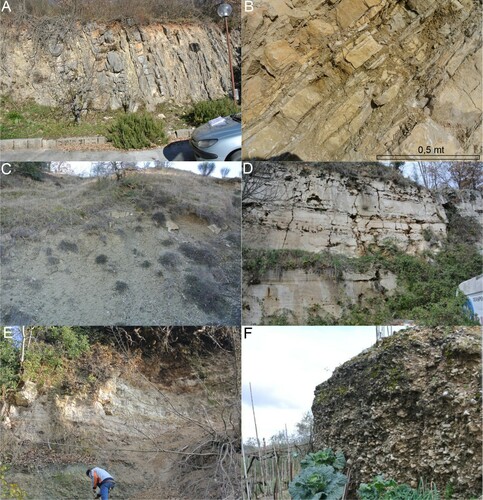
The main geological units cropping out in the Isernia area have been grouped in Meso-Cenozoic bedrock units and Quaternary units of the Isernia intermontane basin. Bedrock units consist mainly of limestone and marls with local intercalation of thin cherty layers ((a,b)), and limit the Isernia basin towards the north-east, east, south and west. Bedrock units also include flysch deposits cropping out to the north-west of the basin ((c)). Quaternary units mainly consist of travertine deposits ((d)), palustrine, alluvial and fluvial-marshy deposits ((e)), and terraced alluvial deposits ((f)) that overall represent the sedimentary filling of the Isernia basin. They furthermore include younger slope and eluvial–colluvial deposits, found widespread along the foot of the carbonate slopes, as well as alluvial and anthropic deposits.
Figure 4. (A) Alternation of strongly inclined, decimetric thick layers of calcilutite and calcarenites with cherty nodules (Matese-Frosolone Unit, UMF in the main map); (B) Alternation of decimetric thick layers of marly limestone and centimetric thick layers of marls and calcarenites with cherty nodules (Matese-Frosolone Unit, UMF in the main map); (C) Silts with local intercalation of sandstone layers (Castelnuovo al Volturno Flysch, FCV in the main map); (D) Alternation of phytoermal travertines and phytoclastic travertines (TR in the main map); (E) Alternation of centimetric travertine layers with centimetric to decimetric thick gravelly, sandy and silty layers (AF2 in the main map); (F) terraced alluvial deposits made of well sorted, matrix-supported, rounded to sub-rounded carbonatic gravels, with local intercalation of sandy layers (AT in the main map).
The map includes the main tectonic elements that have controlled the formation of the Isernia intermontane basin. These elements have been derived from the combination of literature data (CitationAucelli et al., 2018; CitationVezzani et al., 2004), field surveys, morphostructural analyses and borehole data. Tectonic elements consist of high-angle faults that trend NNE–SSW, NE–SW, E–W and ca. NW–SE, and low-angle thrust faults. The latter crop out to the north of the Isernia basin, in correspondence of some klippen in carbonate rocks overlying flysch deposits.
The main geological setting of the Isernia area has been synthesized in the geological cross-section reported in the lower-left corner of the map. The orientation of the cross-section was chosen to be orthogonal to the NW-SE trending high-angle faults and to intercept available borehole data (not reported in the map).
The geomorphological mapping criteria adopted in this paper are in accordance with those used for other published geomorphological maps concerning the Molise territory (CitationAucelli et al., 2010, Citation2013). Geomorphological features consist of: erosional surfaces of complex origin cut into the carbonate bedrock units; fluvial terraces, both erosional and depositional, underlain by Quaternary units; tectono-karst depressions; fluvial gorges and isolated peaks in the areas where carbonate units crop out; alluvial fans, mainly concentrated along the north-eastern border of the basin, carbonate fault slopes; landslides affecting both flysch deposits and the valley flanks of major stream incisions.
4.1.2. Archaeological data
Archaeological data have been grouped in four chronological intervals: Prehistorical age, Roman age, Middle ages and post-Middle ages.
The Lower Palaeolithic site of Isernia la Pineta has been represented with a separate, slightly larger symbol to distinguish it from other prehistoric sites.
Archaeological data distribution highlights that, regardless of the Isernia La Pineta site, prehistoric traces are relatively scarce and have been found only outside the historical and modern urban area of Isernia, on terrace remnants surrounding the Isernia terrace stairs. Conversely, despite some historical findings localized along valley flanks and terrace remnants, most of the archaeological data concerning the historical period is found in the current urban centre of Isernia. Details on the historical settlement development are reported in Section 4.3.2.
4.2. Quaternary morphoevolution of the Isernia intermontane basin
The Quaternary morphoevolution of the Isernia area has been synthesized in four WNW-ESE trending schematic cross-sections placed in the lower-left corner of the map. These cross-sections highlight the tectonic evolution of the Isernia intermontane basin and related depositional and erosional events. The Isernia basin formed during the Lower Pleistocene when block faulting generated a tectonic depression filled by palustrine deposits (sketch A). Around 600 ky, the Isernia basin was deformed by dip-slip faults under the now established NE–SW sense of extension and two travertine units accumulated along the eastern margin of the basin (sketch B). High-angle normal faults active in this period isolated Isernia La Pineta area from the palaeo-Sordo stream area (sketch C). Sketch D shows the present-day geomorphological and tectonic setting of the Isernia area.
4.3. The territory of Isernia and its human occupation
To detail the timing of the landscape evolution and human occupation of the Isernia area, two sequences of sketches concerning respectively the Palaeolithic and the historical period have been produced. Given the small number of available prehistoric data, the two sketches concerning the Palaeolithic period have been extended slightly beyond the western limit of the main map to include two important prehistoric sites.
4.3.1. The landscape during the Palaeolithic period
Human occupation during the Palaeolithic period was strongly influenced by the orographic and hydrographic features of the Isernia area. Lower Palaeolithic hominids privileged the poorly incised and flat river terraces close to the water lines and avoided the mountainous areas, the active floodplains, and the areas affected by travertine and fluvial-marshy sedimentation (sketch A). Landscape setting during the Middle–Upper Palaeolithic is shown in sketch B. During the Middle Pleistocene, tectonic-induced valley incision dominated, causing the formation of several fluvial terraces that were occupied by humans. Since the Upper Pleistocene, the tectonic signal decreased and climatic fluctuations became dominant, slightly reshaping the landscape.
4.3.2. Historical settlement development
Sketches A–D illustrate the historical evolution of the Isernia area together with some aspects concerning land use and slope dynamics.
The location of the Roman and medieval urban centres well reflects the influence of the local geological and geomorphological setting. The presence of a terraced surface limited by two deep incisions favoured the protection of the town whereas large outcrops of travertine deposits provided construction materials. During the Roman period (sketch A), urbanization was largely restricted to the narrow, south-westernmost portion of the Isernia terrace stair, confined by the wall circuit. During the Middle Ages (Scheme B), the inhabited area was first limited to the southernmost margin of the terrace ridge (Early Middle Ages), then gradually expanded towards the northeast, reaching its maximum extension during the High Middle Ages, precisely at the end of the thirteenth century CE, when the medieval wall circuit matched rather well the Roman one.
Only during the last two centuries (sketches C and D), first the central portion of the Isernia terrace, underlain by palustrine and fluvial-marshy deposits, then the north-eastern, larger plateau-like portion of the terrace underlain by travertine deposits, were gradually urbanized. A significant urban expansion occurred only after the II world war (sketch D) and was most likely favoured by the birth of the Molise region in 1963.
Until pre-modern times, the slopes bordering the Isernia terrace were essentially used for cultivations (see sketch B) and the realization of streets/tracks to access the urban centre, and only sporadically occupied by peri-urban and extra-urban buildings. This is most likely due to their poor security (hence the difficulty of protecting them from possible attacks), and scarce stability conditions (due to moderate to very high slope gradients and the presence of poorly consolidated superficial deposits), evidenced by both the Roman terrace wall remains (sketch A) and the diffuse traces of recent landslides (sketch D).
5. Conclusions
In this paper, the relationships between Quaternary landscape evolution and human occupation in the area of Isernia have been investigated by means of a detailed geological and geomorphological map enriched with archaeological data. This map is accompanied by a geological cross-section representative of the geological setting of the Isernia historical centre area and by a qualitative reconstruction of the main Quaternary morphoevolutive sequences that have shaped the landscape. Furthermore, two main phases of human occupation during the prehistoric and historic periods are detailed in two sequences of sketches.
Overall data can be considered a useful cartographic synthesis of the state of art about the landscape features of the Isernia area, its morphoevolution and the related human occupation and adaptation.
Software
The map has been produced using Esri Arcgis 10.7 © for the vector and raster datasets, and Corel Draw 2019 © for the editing.
JOM_Aucelli_et_al_IserniaMap_R1.pdf
Download PDF (40.9 MB)Acknowledgements
The authors are grateful to Mr Bruno Paglione for the information he provided on prehistoric and protohistoric findings in the Isernia area.
Disclosure statement
No potential conflict of interest was reported by the author(s).
Additional information
Funding
References
- Amato, V., Aucelli, P. P. C., Bracone, V., Cesarano, M., & Rosskopf, C. M. (2017). Long-term landscape evolution of the Molise sector of the central-southern Apennines, Italy. Geologica Carpathica, 68(1), 29–42. https://doi.org/10.1515/geoca-2017-0003
- Amato, V., Aucelli, P. P. C., Capozzi, A., De Benedittis, G., Pappone, G., & Rosskopf, C. M. (2013). Environmental changes in the Boiano intramontane basin (Molise, Italy) since the times of ancient Bovianum (IVth century BC). Alpine and Mediterranean Quaternary, 26(1), 15–29.
- Amato, V., Aucelli, P. P. C., Cesarano, M., Filocamo, F., Leone, N., Petrosino, P., Rosskopf, C. M., Valente, E., Casciello, E., Giralt, S., & Jicha, B. R. (2018). Geomorphic response to late quaternary tectonics in the axial portion of the southern Apennines (Italy): A case study from the Calore river valley. Earth Surface Processes and Landforms, 43(11), 2463–2480. https://doi.org/10.1002/esp.4390
- Amato, V., Aucelli, P. P. C., Cesarano, M., Pappone, G., Rosskopf, C. M., & Ermolli, E. R. (2011). The Sessano intra-montane basin: New multi-proxy data for the quaternary evolution of the Molise sector of the central-southern Apennines (Italy). Geomorphology, 128(1–2), 15–31. https://doi.org/10.1016/j.geomorph.2010.12.019
- Amato, V., Cozzolino, M., De Benedittis, G., Di Paola, G., Gentile, V., Giordano, C., Marino, P., Rosskopf, C. M., & Valente, E. (2016). An integrated quantitative approach to assess the archaeological heritage in highly anthropized areas: The case study of Aesernia (southern Italy). ACTA IMEKO, 5(2), 33–43. https://doi.org/10.21014/acta_imeko.v5i2.355
- Angelone, G. (2011). Bombs on target. Isernia, 1943. In G. Cerchia (Ed.), Il Molise e la guerra totale di (Collana Storia E Documenti 3) (pp. 127–158). Cosmo Iannone Editore. ISBN 978-88-516-0120-1.
- Ascione, A., Aucelli, P. P. C., Cinque, A., Di Paola, G., Mattei, G., Ruello, M., Russo Ermolli, E., Santangelo, N., & Valente, E. (2020). Geomorphology of Naples and the Campi Flegrei: Human and natural landscapes in a restless land. Journal of Maps. https://doi.org/10.1080/17445647.2020.1768448
- Aucelli, P., Amato, V., Cesarano, M., Pappone, G., Rosskopf, C., Ermolli, E., & Scarciglia, F. (2011). New morphostratigraphic and chronological constraints for the Quaternary paleosurfaces of the Molise Apennine (southern Italy). Geologica Carpathica, 62(1), 17–26. https://doi.org/10.2478/v10096-011-0002-2
- Aucelli, P. P. C., Cesarano, M., Di Paola, G., Filocamo, F., & Rosskopf, C. M. (2013). Geomorphological map of the central sector of the Matese mountains (southern Italy): An example of complex landscape evolution in a Mediterranean mountain environment. Journal of Maps, 9(4), 604–616. https://doi.org/10.1080/17445647.2013.840054
- Aucelli, P. P. C., Di Paola, G., Valente, E., Amato, V., Bracone, V., Cesarano, M., Di Capua, G., Scorpio, V., Capalbo, A., Pappone, G., Ravera, F., & Rosskopf, C. M. (2018). First assessment of the local seismic amplification susceptibility of the Isernia Province (Molise region, southern Italy) by the integration of geological and geomorphological studies related to the first level seismic microzonation project. Environmental Earth Sciences, 77, 4. https://doi.org/10.1007/s12665-018-7319-4 doi: 10.1007/s12665-017-7179-3
- Aucelli, P. P. C., Robustelli, G., Rosskopf, C. M., Scarciglia, F., di Paola, G., & Lucá, F. (2010). Geomorphological map of the area between Frosolone and Trivento (Molise, Italy). Journal of Maps, 6, 423–434. https://doi.org/10.4113/jom.2010.1039
- Bini, M., Baroni, C., & Ribolini, A. (2013). Geoarchaeology as a tool for reconstructing the evolution of the ApuoVersilian plain (NW Italy). Geografia Fisica e Dinamica Quaternaria, 36, 215–224. https://doi.org/10.4461/GFDQ.2013.36.18-
- Brancaccio, L., Cinque, A., Di Crescenzo, G., Santangelo, N., & Scarciglia, F. (1997). Alcune osservazioni sulla tettonica quaternaria nell’Alta Valle del F. Volturno. Il Quaternario, 10, 321–328.
- Brancaccio, L., Di Crescenzo, G., Rosskopf, C., Santangelo, N., & Scarciglia, F. (2000). Carta geologica dei depositi quaternari e Carta geomorfologica dell’Alta Valle del Volturno (Molise, Italia meridionale). Note illustrative. Il Quaternario, 13, 81–94.
- Brandolini, P., Cappadonia, C., Luberti, G. M., Donadio, C., Stamatopoulos, L., Di Maggio, C., Faccini, F., Stanislao, C., Vergari, F., Pallaga, G., Agnesi, V., Alevizos, G., & Del Monte, M. (2019). Geomorphology of the Anthropocene in Mediterranean urban areas. Progress in Physical Geography, 1–34. https://doi.org/10.1177/0309133319881108
- Bridgland, D. R. (2000). River terrace systems in north-west Europe: An archive of environmental change, uplift and early human occupation. Quaternary Science Review, 19(13), 1293–1303. https://doi.org/10.1016/S0277-3791(99)00095-5
- Burrough, S. L. (2016). Late Quaternary environmental Change and human occupation of the southern African Interior. In S. Jones, & B. Stewart (Eds.), Africa from MIS 6-2. Vertebrate Paleobiology and Paleoanthropology (pp. 161–174). Springer. https://doi.org/10.1007/978-94-017-7520-5
- Casciello, E., Cesarano, M., & Pappone, G. (2006). Extensional detachment faulting on the Tyrrhenian margin of the southern Apennines contractional belt (Italy). Journal of the Geological Society, 163(4), 617–629. https://doi.org/10.1144/0016-764905-054
- Cinque, A., Patacca, E., Scandone, P., & Tozzi, M. (1993). Relationships between surface geological features and deep lithospheric structures. Annali di Geofisica, 36(2), 249–260. https://doi.org/10.4401/ag-4283
- Coltorti, M., & Cremaschi, M. (1982). Depositi quaternari e movimenti neotettonici nella conca di Isernia. Contributi Conclusivi per la carta Neotettonica d’Italia, Consiglio Nazionale Ricerche. Progresso Fin. Geodinamica, 506, 173–198.
- Coltorti, M., Feraud, G., Marzoli, A., Peretto, C., Ton-That, T., Voinchet, P., Bahain, J. J., Minelli, A., & Thun Hohenstein, U. (2005). New 40Ar/39Ar, stratigraphic and paleoclimatic data on the Isernia La Pineta Lower Palaeolithic site, Molise, Italy. Quaternary International, 131, 11–22. https://doi.org/10.1016/j.quaint.2004.07.004
- Cremaschi, M. (1983). La serie pleistocenica di Isernia La Pineta (Molise) e la posizione stratigrafica dei suoli di abitato paleolitici in essa inclusi. In M. Coltorti (Ed.), Isernia La Pineta. Un accampamento più antico di 700.000 anni (pp. 49–62). Calderini.
- D'Henry, G. (1989). Alcune considerazioni sul processo di romanizzazione di Isernia. Almanacco del Molise, 5–14.
- De Benedittis, G. (2010). La via Sulmo-Aequum Tuticum. In G. De Benedittis (Ed.), La Provincia Samnii e la viabilità romana (pp. 39–54). Volturnia Edizioni. ISBN 978-88-96092-02-6.
- Di Donato, V., Ruello, M. R., Liuzza, V., Carsana, V., Giampaola, D., Di Vito, M. A., Morhange, C., Cinque, A., & Russo Ermolli, E. (2018). Development and decline of the ancient harbor of Neapolis. Geoarcheaology, 33(5), 542–557. https://doi.org/10.1002/gea.21673
- Esposito, E., Laurelli, L., & Porfido, S. (1995). Damage pattern in historical centres: Isernia, an example in southern Italy. Annali di Geofisica, 38(5–6), 663–677.
- Figliuolo, B. (1985). Il terremoto napoletano del 1456: il mito. In Terremoti e storia. Quaderni storici, Nuova Serie 20, 60 (3), 771–801. Società editrice il Mulino S.p.A.
- Foerster, V., Vogelsang, R., Junginger, A., Asrat, A., Lamb, H. F., Schaebitz, F., & Trauth, M. H. (2015). Environmental change and human occupation of southern Ethiopia and northern Kenya during the last 20,000 years. Quaternary Science Review, 129, 333–340. https://doi.org/10.1016/j.quascirev.2015.10.026
- Galanti, G. M. (1781). Descrizione dello stato antico ed attuale del contado di Molise. La società letteraria e tipografica, 58, 186–202.
- Giaccio, B., Hajdas, I., Isaia, R., Deino, A., & Nomade, S. (2017). High-precision 14C and 40Ar/39Ar dating of the Campanian Ignimbrite (Y-5) reconciles the time-scales of climatic-cultural processes at 40 ka. Scientific Reports, 7, 45940. https://doi.org/10.1038/srep45940
- Gioia, D., Bavusi, M., Di Leo, P., Giammatteo, T., & Schiattarella, M. (2020). Geoarchaeology and geomorphology of the Metaponto area, Ionian coastal belt, Italy. Journal of Maps, 16(2), 117–125. https://doi.org/10.1080/17445647.2019.1701575
- Gioia, D., Del Lungo, S., Sannazzaro, A., & Lazzari, M. (2019). Geological and geomorphological Controls on the Path of an Intermountain Roman road: The case of the Via Herculia, Southern Italy. Geosciences, 9, 9. https://doi.org/10.3390/geosciences9090398
- Hippolyte, J. C., Angelier, J., & Roure, F. (1994). A mayor geodynamic change revealed by Quaternary stress patterns in the southern Apennines (Italy). Tectonophysics, 230, 199–210. https://doi.org/10.1016/0040-1951(94)90135-X
- Hoelzmann, P., Keding, B., Berke, H., Kröpelin, S., & Kruse, H. J. (2001). Environmental change and archaeology: Lake evolution and human occupation in the eastern Sahara during the Holocene. Palaeogeography, Palaeoclimatology, Palaeoecology, 169(3–4), 193–217. https://doi.org/10.1016/S0031-0182(01)00211-5
- Iorillo, U., & Zullo, E. (2018). L’evoluzione urbanistica d’Isernia tra l’alto medioevo e l’età contemporanea. In ArcheoMolise di Testa A. (Ed.), 30, 24–29. ISSN: 2036-3028.
- Montone, P., Amato, A., & Pondrelli, S. (1999). Active stress map of Italy. Journal of Geophysical Research, 104(25), 595–610. https://doi.org/10.1029/1999JB900181
- Palumbo, C. (2018). Isernia dal V al XVIII secolo. In ArcheoMolise di Testa A. (Ed.), 30, 30–37. ISSN: 2036-3028.
- Peretto, C., Arnaud, J., Moggi-Cecchi, J., Manzi, G., Nomade, S., Pereira, A., Falguères, C., Bahain, J. J., Grimaud-Hervé, D., Berto, C., Sala, B., Lembo, G., Muttillo, B., Gallotti, R., Thun Hohenstein, U., Vaccaro, C., Coltorti, M., & Arzarello, M. (2015). A human deciduous tooth and new 40Ar/39Ar dating results from the Middle Pleistocene archaeological site of Isernia La Pineta, Southern Italy. PLoS ONE, 10, e0140091. https://doi.org/10.1371/journal.pone.0140091
- Rosskopf, C. M., De Benedittis, G., & Mauriello, P. (2006). Indagini geoarcheologiche integrate nel Molise centrale (Italia meridionale): il ponte romano di Tufara. Il Quaternario, 19(2), 239–250.
- Russo Ermolli, E., Romano, P., Rullo, M., & Barone Lunaga, M. R. (2014). The natural and cultural landscape of Naples (southern Italy) during the Graeco-Roman and late Antique periods. Journal of Archaeological Science, 42, 399–411. https://doi.org/10.1016/j.jas.2013.11.018
- Sanchez, J. G. (2018). Isernia tra il mondo sannita e la Tardo antichità. Un excursus archeologico. In ArcheoMolise di Testa A. (Ed.), 30, 20–29. ISSN: 2036-3028.
- Sarno, E. (2014). La cartografia storica tratturale per lo studio dei paesaggi della transumanza. Un caso di studio. Bollettino AIC, 150, 52–69. ISSN 2282-472x.
- Shao, Q., Bahain, J. J., Falguères, C., Peretto, C., Arzarello, M., Minelli, A., Hohenstein, U. T., Dolo, J. M., Garcia, T., Frank, N., & Douville, E. (2011). New ESR/U-series data for the early Middle Pleistocene site of Isernia la Pineta, Italy. Radiation Measurements, 49, 847–852. https://doi.org/10.1016/j.radmeas.2011.03.026
- Terzani, C. (1991). La colonia latina di Aesernia; Aesernia in SAMNIVM. Archeologia del Molise. pp. 111–112, 225–227.
- Testa, A. (2018, gennaio-Aprile). Aesernia, Isernia, ‘sernia. Monographic Issue in ArcheoMolise, 30, 114. ISSN: 2036-3028.
- Valente, E., & Cozzolino, M. (2019). GIS mapping of the archaeological sites in the Molise region (Italy). Archeologia e Calcolatori, 30, 367–385. https://doi.org/10.19282/ac.30.2019.21
- Vezzani, L., Ghisetti, F., & Festa, A. (2004). Carta Geologica del Molise. Regione Molise. S.E.L.C.A.