
ABSTRACT
A comprehensive geomorphological and structural mapping of the largest landslides in the central-eastern Southern Alps (NE Italy) is presented. Their occurrence in this Alpine sector is discussed in relation with structural geological features (bedding and faults), which are largely conditioned by the Giudicarie and Schio-Vicenza regional fault systems. Tectonic rock damaging here coexists with high relief stored energy and active deformation, which is testified by present seismicity and cumulative earthquake moment release. Based on updated rock failure ages, slope activity is concentrated at 5-3 and 1 ka, as primarily enhanced by climatic and seismic controls. The analysis of predisposing and driving factors poses the question of present and future landslide hazards for these densely inhabited Alpine valleys.
Introduction
Landslides can deeply modify mountain landscapes, permanently alter drainage patterns and have catastrophic impacts on people and infrastructures (e.g. CitationAbdulwahid & Pradhan, 2017; CitationCrosta et al., 2004; CitationErmini & Casagli, 2003). A detailed mapping of their location and the study of their mechanisms are crucial in order to achieve reliable hazard maps and correctly assess their destructive potential (CitationAbdulwahid & Pradhan, 2017; CitationTrigila et al., 2018). For this reason, large landslides in the Alps have been also studied in order to assess their age, in relation with structural setting (bedding, faults, joints), ongoing climatic change, and seismicity (CitationIvy-Ochs et al., 2017a; CitationRossato et al., 2020; CitationStead & Wolter, 2015; CitationTrigila et al., 2007).
The region of the Southern Alps (Italy) comprised between the Lake Garda to the south and the internal Alpine chain to the north, named the Giudicarie realm, is characterised by the presence of several deep-seated rock slope failures, most of which are rock avalanches (). Rock avalanches are rare and large mass movements with extremely rapid flow of fragmented rock and long runout, which also exhibit distinctive depositional landforms (CitationStrom, 2006). In order to highlight the reason for their frequency in this sector of the Alps, in addition to older studies that mainly focused on deposit extension (CitationLargaiolli, 1990; CitationOetheimer, 1989; CitationPerna, 1991; CitationTrener, 1924; ), great effort has been recently put on understanding their mechanisms, timing and drivers (CitationIvy-Ochs et al., 2017a, Citation2017b; CitationMartin et al., 2014; CitationSpreafico et al., 2018; Citationvon Wartburg et al., 2020; CitationZampieri & Adami, 2013). The prevalence of such rock failures has been suggested to be given by the combined action of different factors, such as extreme relief, tectonic setting, climate, and seismic ground shaking (CitationIvy-Ochs et al., 2017a; CitationRossato et al., 2020).
Figure 1. Geographical map of the study area, with position of major catastrophic landslides (A, Tovel; B, Molveno; C, Marocche di Dro; D, Palon; E, Cima Salti; F, Gorte and Passo San Giovanni; G, Lavini di Marco; H, Castelpietra; I, La Marogna). The viewpoints for the photographs of and main faults (IL, Insubric Line; NG, North Giudicarie; SG, South Giudicarie; SV, Schio-Vicenza; VS, Valsugana) are also shown.
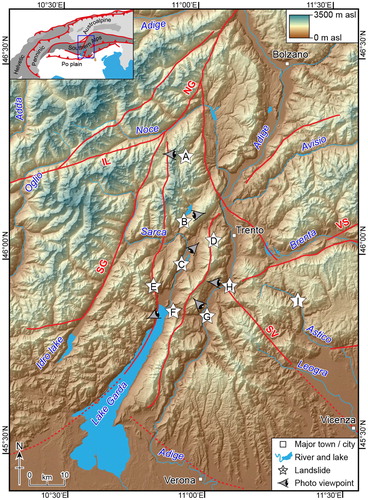
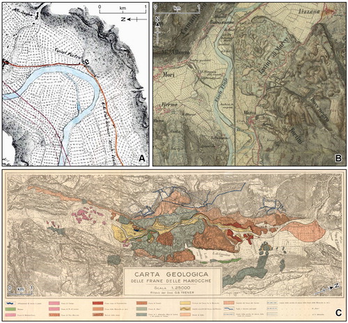
Figure 2. Historical representation of landslides in the Adige and Sarca valleys. (A) Castelpietra in 1845 by Leopold von Claricini, freely available in Historische Karten Tirol (https://hik.tirol.gv.at; accessed: May 2020). (B) Lavini di Marco in 1869–1887 by the Habsburg Empire Third Military Survey (CitationMolnár & Timár, 2009), freely available in MAPIRE (https://mapire.eu; accessed: May 2020; CitationBiszak, 2017). (C) Marocche di Dro in the geological map by CitationTrener (1924).
In this paper and the related Main Map, we present an updated geomorphological and structural mapping of the largest landslides of this Alpine sector. A comprehensive view of these natural events, interpreted also in the framework of remote image analysis and runout modelling, allows to interpret their occurrence in relation with structural geological features and to examine the possible driving factors.
Geological and tectonic setting
The study area is located in the central-eastern Southern Alps, along the western margin of the Adriatic indenter (CitationViganò et al., 2008). The crucial role of this Alpine sector is testified by its long-lived deformation, which started in the Late Cretaceous during the initial phases of the orogenic history and is still active today (CitationCastellarin et al., 2006; CitationViganò et al., 2015, Citation2018). This deformation is responsible for the strong heterogeneity observed by local seismic tomography at both the crustal and lithospheric scales (CitationKissling et al., 2006; CitationViganò et al., 2013). Here, three main tectonic systems intersect: the ENE-WSW compressive Valsugana, the NNE-SSW transpressive Giudicarie, and the NW-SE strike-slip Schio-Vicenza fault systems (; see Main Map). These fault systems accommodated most of the Cenozoic deformation during two main compressive tectonic events. The first affected the Giudicarie fold-and-thrust belt and the Valsugana system (Middle-Late Miocene), the second activated the transfer fault zone of the Schio-Vicenza system and was also responsible for clear effects in the more external Giudicarie belt (Late Miocene-Pliocene; CitationCastellarin et al., 2006).
This tectonic complexity produced a varied lithological pattern, where lithostratigraphy extends from the pre-Permian Southalpine and Austroalpine metamorphic basements to Plio-Quaternary rocks of the Po and Venetian plains (see Main Map). In particular, the Giudicarie and Schio-Vicenza domains are characterised by an extensive sedimentary cover of mainly carbonate sequences of Middle Triassic-Jurassic age, which shows a lateral thickness variation between the Trento platform, the Lombardian basin to the west and the Belluno basin to the east (CitationCastellarin et al., 2006). This sedimentary cover has a typical triangle shape due to the pervasive NNE-SSW Giudicarie faults and the lateral confinement by rigid crustal bodies, the Adamello intrusion to the west, the Athesian Volcanic platform to the northeast, and the Cenozoic magmatic rocks to the southeast (CitationBigi et al., 1990; see cross-sections in the Main Map).
The central-eastern Southern Alps are undergoing deformation still today and are one of the most seismically active provinces of Northern Italy. They show relevant historical and instrumental seismicity, with low-to-moderate magnitude shallow seismicity mainly concentrated along the Southalpine boundary (CitationGuidoboni et al., 2018; CitationRovida et al., 2019). In the Giudicarie and Schio-Vicenza domains, earthquakes are typically clustered and show alignments in very good agreement with tectonic structures (CitationViganò et al., 2015).
Materials and methods
The landslides of the Giudicarie and Schio-Vicenza domains were studied applying different techniques, in order to obtain an updated view of their geomorphological and structural features. Based on available geological maps, deposit extents were mapped using high-quality digital terrain models (DTM) from LiDAR surveys, having a resolution of 1–2 m for the Trentino region (depending on the area – freely distributed by the Autonomous Province of Trento at: https://siat.provincia.tn.it/stem) and 5 m for the Veneto region (freely distributed by the Veneto Region at: https://idt2.regione.veneto.it/). In particular, landslide deposits are identified considering DTM texture, slope and aspect maps, and classified according to CitationHungr et al. (2014). Field work was also done, in order to both confirm available information and recognise specific geological and geomorphological features. For this study, the area of each landslide deposit was recalculated considering only the outcropping mass, not the area below more recent deposits (if present). When landslide bodies are overlain by more recent sediments, such features are reported in the Main Map. Deposits are grouped into gravity-related (i.e. scree and talus) and water-related (i.e. alluvial and lacustrine), following the Geological Service guidelines (CitationISPRA, 1992). Timing is a key parameter in landslide studies. In the Main Map, we report absolute ages (already published cosmogenic nuclide exposure and radiocarbon dating), together with sample locations, and ages based on stratigraphic evidence. Radiocarbon ages are recalibrated with OxCal vers. 4.3 (CitationBronk Ramsey, 2009) using the IntCal13 curve by CitationReimer et al. (2013). As a general rule, to assign a relative age the reference landslide is chosen as the larger deposit.
The accompanying 1:200,000 geological map was obtained using different sources. Lithology and tectonics are largely from the CARG (CARtografia Geologica) project database (scale 1:50,000; freely distributed by ISPRA at: www.isprambiente.gov.it). For the Trentino region, geology is mainly from the following CARG sheets and illustrative notes: Appiano (CitationAvanzini et al., 2007), Bagolino (CitationBargossi et al., 2014), Malè (CitationDal Piaz et al., 2007), Mezzolombardo (CitationAvanzini et al., 2012), Monte Adamello (CitationBrack et al., 2008), Ponte di Legno (CitationChiesa et al., 2011), Rabbi (CitationMartin et al., 2009), Riva del Garda (CitationCastellarin et al., 2005a), Tione di Trento (CitationCastellarin et al., 2005b), Trento (CitationAvanzini et al., 2010), or, in a lesser extent, derived from detailed surveys to compile the local hazard map (geological database available at www.protezionecivile.tn.it). For the surrounding regions, the CARG database is combined with the more recent 1:100,000 geological maps, the CitationCastellarin (1981) map compilation and the structural model of Italy (CitationBigi et al., 1990). The lithological legend was created and simplified according to CitationBosellini et al. (1999).
Results
The studied landslides are mostly distributed along a narrow area stretching from the northern edge of Lake Garda to the internal Alps, between the lower Sarca and Adige River valleys. The large landslide deposits with big boulders, typically occurring in these valleys, were called ‘Marocche’. CitationPerna and Sauro (1978) pointed out that initially the term ‘Marocca’ referred to a landslide onto a glacier, with the debris then being transported and deposited by the glacier, but recent studies proved that most of these events are more recent (e.g. CitationMartin et al., 2014).
In this section, each landslide or landslide group is discussed, with reference to the summary table in the Main Map with area and volume of deposits, involved lithologies, rock failure classification (see also ) and age.
Tovel
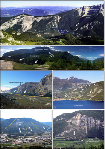
The Tovel landslides are located in the upper reaches of the Tovel Valley in the Adamello Brenta Nature Park in the northern Brenta Dolomites (frame A in the Main Map). The extensive landslide deposits cover an area of ∼5 km2 and are composed of seven bodies distributed at different elevations, from the highest Bergia-Sassere (BS in the Main Map) to the lowest Glare North (GN). Their total volume is estimated in 200–280 Mm3 of rocks belonging to the Dolomia Principale and Calcare di Zu (CitationOetheimer, 1989) and all of them, with the exception of the Dosso del Lago rockslide (DL), are classified as rock avalanches. Detachment areas are mainly located along the eastern valley side (Costa Lucanica deposit, CL, as the only exception), where the dominant high-angle strike-slip fault system (Val Strangola fault in A) shapes the valley morphology with the steep Val Scura and Mt. Corno faces. Although the deposit absolute ages are not known, some timing constraints can be achieved from stratigraphic relationships. The Selvata deposit (SE) underlies, and thus is older than, Bergia-Sassere. For the same reason, the main Tovel deposit in the middle valley, with its source area located in the big detachment scarp to southeast, is older than Dosso del Lago. The Tovel lake formed inside the Tovel deposit (TO) and showed a sudden rise in lake level, testified by the drowning of a submerged forest dated by dendrochronology at 1597 AD likely due to a minor rockfall blocking lake outflow (CitationFerretti & Borsato, 2004; CitationOetheimer, 1989). More to the north, Glare North overlies Glare South (GS) and is considered the youngest failure due to the clear absence of vegetation on the blocky deposit.
Figure 3. Panoramic views of the (A) Tovel, (B) Molveno, (C) Marocche di Dro, (D) Gorte, (E) Lavini di Marco and (F) Castelpietra detachment areas and deposits (CL, Costa Lucanica; DL, Dosso del Lago; GS, Glare South; LA, Lavini di Marco; TO, Tovel; VA, Varini). Main structural features are marked by yellow lines.
Molveno
The Molveno landslides (frame B in the Main Map, acronym MO) are located in the upper reaches of the Bondai Valley in the southern part of the Brenta Dolomites, near the town of Molveno. A deposit area of 4.9 km2 and a volume of approximately 600 Mm3 were determined (Citationvon Wartburg et al., 2020). The detachment area is the prominent scarp located to the west of the deposits on Mt. Soran, with rocks of Calcari Grigi limestones mainly being displaced. The deposits have several large scarps and prominent lineaments, which led previous researchers to interpret as being the result of multiple events. 36Cl dating results indicate that the deposits were emplaced during a single event at 4.8 ± 0.5 ka. This points to failure within the debris during and soon after emplacement as the origin of the internal scarps in the deposit. Numerical runout modelling with Dan3D-Flex shows that the morphology of the Molveno deposits could have resulted from a combination of runup and extensional spreading of the debris along the complex valley floor topography.
Marocche di Dro
Marocche di Dro is the name of the impressive blocky deposits located in the Sarca Valley north of Lake Garda, studied since a long time (e.g. CitationTrener, 1924; C; frame C in the Main Map). Based on detailed field mapping and cosmogenic 36Cl exposure dating of boulders, the Marocche di Dro deposits (∼10.5 km2 area) could be divided into two rock avalanche bodies; the Marocca Principale (MP in the Main Map) to the north and the Kas (KA) to the south (CitationIvy-Ochs et al., 2017a). The older deposit, Marocca Principale, which comprises an estimated 1000 Mm3 of predominantly Rotzo Formation limestones, relates to a failure event at 5.3 ± 0.9 ka. The detachment area is located mainly in the alcove between Mt. Casale and Mt. Granzoline. During the Kas rock avalanche, at 1.1 ± 0.2 years ago the southern third of the Marocca Principale deposit was buried. Detachment zone lies below Mt. Brento. The deposit has an estimated volume of 300 Mm3.
Palon
The Palon rock avalanche is located on the north-western face of Mt. Palon; this peak belongs to a mountainous ridge that separates the Adige and Sarca valleys, south-west of the town of Trento (frame D in the Main Map). The deposits (PA in the Main Map), with an estimated area of 1.4 km2, lie between about 1900 and 750 m a.s.l. and form a narrow strip with a length of approximatively 4 km. The landslide mechanism, which rapidly evolved from an initial slide along bedding planes to a rock avalanche, moved about 25 Mm3 (CitationLargaiolli, 1990; updated) of limestones and marls (Rotzo Formation, San Vigilio Oolite, Rosso Ammonitico Veronese, Scaglia Variegata and Scaglia Rossa). In the upper scarp, the rupture plane is clearly visible and formed by bedding planes dipping at 20–23°.
Cima Salti
The Cima Salti landslides is located near the Tenno lake, north-west of the town of Riva del Garda (frame E in the Main Map). CitationSpreafico et al. (2018) present a re-interpretation of the Cima Salti deposits (CS in the Main Map). Previous works had interpreted the deposits to have a volume of 20–30 Mm3 and to have dammed the Tenno lake in the Middle Ages. Based on detailed field mapping and runout simulations with the codes DAN3D and SHALTOP (which produced comparable results), CitationSpreafico et al. (2018) report that the Tenno lake was not dammed by the deposit and that the deposit volume is only 2–5 Mm3, corresponding to an area of 0.1 km2, and made up of Maiolica Formation limestones. Based on the runout modelling and the distribution of the deposits, the authors interpret the event to have fallen onto stagnant ice melting in situ during the Lateglacial period. The reconstruction of this event is particularly challenging and debated due to its old age, markedly different from the other landslides presented in this study.
Gorte and Passo San Giovanni
The Gorte landslide deposit is located at the north-eastern end of Lake Garda, south of the town of Nago (frame F in the Main Map, acronym GO). The 100 m-thick block of Calcari Grigi and San Vigilio Oolite limestones detached along the dip slope basal detachment surface, broke up and filled the small Santa Lucia Valley to the southwest. Considering the main deposits and those detached from the minor detachment scarp to the southwest, they have an area of 1.3 km2 and an estimated volume of 101 Mm3 (CitationPerna, 1991).
Close to Gorte, to the east, the Passo San Giovanni deposits (frame F in the Main Map, acronym PG) have an area of 0.9 km2 and an estimated volume of more than 110 Mm3 (CitationPerna, 1991). They come from a narrow N-S oriented valley and moved an about 200 m-thick block of Calcari Grigi, San Vigilio Oolite and Rosso Ammonitico Veronese limestones. The blocky deposit filled the original paleovalley east of Nago, being likely responsible both for the damming of the Loppio lake and the formation of the cone-like hills (toma) west of the pass.
Lavini di Marco
The Lavini di Marco rock avalanche deposit, also known as ‘Marocca di Marco’, is located along the left side of the Adige Valley, near the town of Rovereto (B; frame G in the Main Map, acronym LA). Covering an area of 4.2 km2, the deposit volume is estimated at 200 Mm3 (CitationMartin et al., 2014). The deposit is made up of Calcari Grigi limestones that detached from the western slope of Mt. Zugna Torta. The Lavini di Marco can be subdivided into at least two different rock avalanche bodies, the main deposit known as Lavini di Marco (the principal) and the much smaller Costa Stenda deposit, with the latter overlying the former. We calculated a mean age for the Lavini di Marco and Costa Stenda rockslides of 3.0 ± 0.4 ka (CitationMartin et al., 2014). The significantly younger ages for the bedrock sliding plane (1600 ± 100 and 1400 ± 100 years) are interpreted to record small-scale reactivation or failure of thin plates from the dip slope bedrock. This as well seems to overlap in time with a catastrophic flooding event of the Adige River in Verona, as reported in the Fulda Annales, in 883 AD. Only the single age of 800 ± 200 years from the head scarp suggests activity at Lavini di Marco coincident with historical earthquakes (CitationGuidoboni et al., 2018).
Besides Lavini di Marco, the Corna Calda (CC), Dosso Gardene (DG) and Varini (VA) deposits cover a total area of 2.3 km2 (see the Main Map). CitationAbele (1974) reported an estimated volume of 16 Mm3 for Varini. All of these failures are interpreted as rock slides along the dip slope bedrock of the Mt. Zugna Torta ridge.
Castelpietra
Castelpietra (area 0.4 km2, volume 6 Mm3) comprises a compact blocky deposit on the Adige River alluvial plain (A), south of the town of Calliano (frame H in the Main Map, acronym CP). The detachment area is the Cengio Rosso rock wall, which is also the source of recent rockfall debris that buries the landslide deposits on the upper side. Boulders in the main deposit, mainly Dolomia Principale dolostones and Calcari Grigi Group limestones, range up to 20 m in diameter. 36Cl exposure dates from two boulders in the main blocky deposit point to a failure event at 1.0 ± 0.3 ka (CitationIvy-Ochs et al., 2017b).
La Marogna
The La Marogna landslide is the only event reported in this study that occurred in the Veneto Region, along the upper reach of the Astico Valley, near the village of Casotto (frame I in the Main Map). The slope of the Astico Valley, location of the La Marogna rock avalanche (estimated 0.9 km2 area and 17 Mm3 volume, LM in the Main Map), is carved on the limb of an anticline fold developed during Neogene shortening of the eastern Southern Alps (CitationZampieri & Adami, 2013). The ENE-trending fold axis is parallel to the main thrusts of the chain (CitationCastellarin et al., 2006) and to the wider folds of the contiguous Asiago plateau (CitationBarbieri & Grandesso, 2007; cf. Main Map). The folded rocks belong to the Dolomia Principale carbonates. Beds are sub-horizontal in the upper part, while towards the valley bottom, they increasingly dip up to 50°. Due to the fold curvature, the sliding surface, which is a thrust dipping 35° downslope, cuts across rock beds at the base of the head scarp and is parallel to them in the lower slope (Zampieri & Adami, Citation2013). This predisposing structural setting, given by the co-existence of folded bedding and the inclined fault, has led to known large rock failures which dammed the Astico River at 925–655 years cal BP (CitationBarbieri & Grandesso, 2007; CitationTecca et al., 2013).
Discussion and conclusions
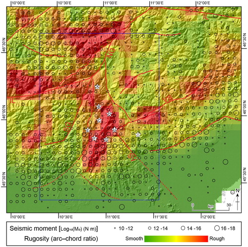
The Giudicarie fold-and-thrust belt is primarily responsible for the asymmetric structure of the lower Adige and Sarca valleys. In fact, while eastern valley flanks dip almost parallel to bedding, western ones are steeper because of the thrust frontal ramps. In terms of landslide mechanisms, this architecture generally makes the first ones more prone to sliding and the second ones to rockfalls. The Palon, Gorte and Lavini di Marco rock avalanches best represent this first case, where bedding planes coherently dip 20–25° towards NW (D–E). Although differently oriented due to local folding (SE-dipping planes of 20–25°), also the basal rupture planes of the Molveno rock avalanche are parallel to bedding (B). In contrast, the Marocche di Dro rock avalanches are due to a collapse just at the hanging-wall of the thrust front (C). Tectonics exerts a major control not only in terms of bedding orientation, but also of location and orientation of faults, shear zones and joints. Together with the low-angle faults of the Giudicarie system, the intersecting high-angle Schio-Vicenza faults enable pervasive fracture development and detachment of huge blocks from valley sidewalls. These vertical fault planes often border detachment areas, such as the Gorte, Passo San Giovanni and Lavini di Marco events (see Main Map). In a similar way, N-S oriented vertical strike-slip faults shape the Tovel Valley morphology, being the origin of prominent source detachment scarps on the eastern valley side (A). Within the Schio-Vicenza domain, the Castelpietra rock avalanche is located just at the north-western tip of the main Schio-Vicenza fault, which is seismically active (CitationViganò et al., 2008, Citation2018). The distribution of the cumulative seismic moment, which can represent the total seismic energy released, shows that the lower Giudicarie (Lake Garda and lower Sarca Valley) and the Schio-Vicenza domains (Lessini area) are both affected by present-day deformation (). Despite earthquakes with reported equivalent magnitude Me = 6 being rare in the region (CitationGuidoboni et al., 2018), recurrent seismicity is able to reduce rock strength leading to the progressive increase in the rock fatigue process (CitationGischig et al., 2016). In fact, earthquakes not only trigger landslides, with higher magnitudes exerting a primary control on their volume, but their geomorphic work is also to seismically uplift and erode topography using the released seismic moment (CitationLi et al., 2019). In this sense, the energy stored in the geomorphic relief is, at least in part, resulting from the tectonic control of seismicity at the mountain scale. The arch-chord ratio rugosity index (CitationDu Preez, 2015; ), calculated using 5×5 km cells on a 20-m resolution DTM, shows a significant lateral variation of the Southern Alps topography. Relatively rough areas are the Giudicarie, the Valsugana belt and some portions close to the Insubric Line in the internal chain. In the study area, most of the large landslides are concentrated in the region where both relatively high seismic moment released and stored energy relief occur. The only exception is the La Marogna rock avalanche. It is located within the Schio-Vicenza tectonic domain, which has a great seismic potential (CitationTrippetta et al., 2019), but was less active in building relief because it is characterised by a dominantly strike-slip major fault zone.
Timing of landslide occurrence is also a key parameter in order to understand their frequency and to examine driving factors. The present shape of the Adige and Sarca valleys is strongly connected to the Pleistocene glaciations, in particular to the Last Glacial Maximum (30–16.5 ka). At that time, thick valley glaciers were feeding the piedmont lobes of Garda (CitationMonegato et al., 2017) and Rivoli (CitationVenzo, 1961). The glacier collapse occurred at about 18–17 ka (CitationRossato & Mozzi, 2016; CitationRavazzi et al., 2014) and the valleys became ice-free in a very short time (CitationWirsig et al., 2016). Therefore, it is unlikely that any of the studied landslides, with the possible exception of Cima Salti with a suggested Lateglacial age (CitationSpreafico et al., 2018), can be attributed to debuttressing after glacier withdrawal (cf. CitationIvy-Ochs et al., 2017a). The other dated landslides are clustered in two periods, young enough to exclude that glacial debuttressing played a significant role. The first period of increased landslide activity occurred between 5 and 3 ka ago, which includes the Marocca Principale (5.3 ± 0.9 ka), Molveno (4.8 ± 0.5 ka) and Lavini di Marco (3.0 ± 0.4 ka) rock failures, together with the Dosso Gardene (younger than 6630–6290 years cal BP) (see the Main Map). This phase at the transition from the Middle to the Late Holocene shows a shift to wetter, colder climate (CitationIvy-Ochs et al., 2017a; CitationZerathe et al., 2014), as also marked by the occurrence of extreme meteorological events (CitationRossato et al., 2015). Pore pressure increase related to periods of intense rainfall is known to trigger landslides (e.g. CitationSchuster & Wieczorek, 2002) and the coincidence of this older group of events with a phase of climate degradation suggest a possible connection. However, due to the absence of historical chronicles and to the resolution of the dating methods, the relationship between climate and landslide events remains tenuous. The second period is about 1 ka ago, as evidenced by the ages of Kas (1.1 ± 0.2 ka), Castelpietra (1.0 ± 0.3 ka), La Marogna (925–655 years cal BP) and Varini (younger than 1385–980 years cal BP) landslides. In the same area near Rovereto, a stalagmite failure at the Cogola di Giazzera cave (1060 ± 70 AD) and the Prà da Lago rockslide (1020–1260 AD) have the same age (CitationIvy-Ochs et al., 2017b and references therein). The close coincidence in time of these several large events, all located in a relatively small area, points to a very probable seismic origin. The seismic crisis associated to the 9 Nov 1046 ‘Middle Adige Valley’ earthquake, with epicentre in the Schio-Vicenza tectonic domain (about 6 km southeast of Rovereto) and maximum estimated intensity IX MCS (Mercalli-Cancani-Sieberg scale; CitationGuidoboni et al., 2018), is the most probable candidate. Although a triggering due to seismic shaking cannot be ruled out, for at least some of these events, the energy of the seismic sequence efficiently and permanently damaged rock slopes, reducing the internal forces of the rock mass (CitationGischig et al., 2016). This process was also favoured by possible local amplifications of ground motion due to trapped seismic waves within the rocks of the vertical faults reaching the surface (CitationRovelli et al., 2002).
In conclusion, final remarks can be summarised as follows:
DTM-based detailed mapping of the large rock failures of the Giudicarie and Schio-Vicenza domains gives an updated view of their deposits (limit, area, volume) and detachment areas, together with involved lithologies and landslide classification.
A comprehensive analysis of structural features (bedding attitude and fault location and orientation with respect to slopes) shows relations between rock failures and regional tectonics, which also exerts a major control on the relief energy.
Enhanced slope activity is concentrated in two periods (5-3 and 1 ka) interpreted as due to primarily climatic and seismic controls, respectively. The occurrence of Lateglacial or Early Holocene events looks to be very limited in the study area.
Coexisting pervasive damage due to past tectonics, high relief energy and active deformation testified by recent seismicity, together with historic ages of several failures, poses the question of the present and future hazards of these densely inhabited valleys of the Alps.
Software
ESRI® ArcGISTM 10 was used to create the geodatabase and compile both the litho-structural map and the DTM landslide frames. These levels were later assembled and refined using Adobe® Illustrator® CC to add the geological cross-sections, the summary table and other text and symbols.
Main_Map_revised.pdf
Download PDF (107.8 MB)Acknowledgements
The authors gratefully acknowledge Paolo Campedel and Paolo Trainotti for their support, Jordan Aaron for data of and Davide Scafidi for assisting in preparing . Matteo Visintainer and Jonas von Wartburg are also thanked for some photographs of . Jorge Galve, Pierluigi Brandolini and Chandra Jayasuriya are gratefully acknowledged for their constructive comments and suggestions.
Figure 4. Scheidegger plot (CitationScheidegger, 1973) extended by the datasets of CitationLi (1983) and CitationMitchell et al. (2020). The H/L ratio (fall height, H; runout length, L) is available for some of the studied rock avalanches (red inverted triangles).
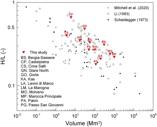
Figure 5. Distribution of the cumulative seismic moment from historical and 1994–2019 instrumental seismicity (CitationViganò et al., 2015; updated) and the arc–chord ratio rugosity index (5×5 km squares; CitationDu Preez, 2015). Major tectonic lineaments and studied landslides are also shown (codes as in ). The blue frame is the study area.
Disclosure statement
No potential conflict of interest was reported by the author(s).
Additional information
Funding
References
- Abdulwahid, W. M., & Pradhan, B. (2017). Landslide vulnerability and risk assessment for multi-hazard scenarios using airborne laser scanning data (LiDAR). Landslides, 14(3), 1057–1076. https://doi.org/10.1007/s10346-016-0744-0
- Abele, G. (1974). Bergstürze in den Alpen – ihre Verbreitung, Morphologie und Folgeerscheinungen. Wissenschaftliche Alpenvereinshefte, 25, 1–230.
- Avanzini, M., Bargossi, G. M., Borsato, A., Castiglioni, G. B., Cucato, M., Morelli, C., Prosser, G., & Sapelza, A. (2007). Note illustrative della Carta Geologica d’Italia alla scala 1:50,000, Foglio 026 ‘Appiano’. APAT, Dipartimento Difesa del Suolo, Servizio Geologico d’Italia, p. 184.
- Avanzini, M., Bargossi, G. M., Borsato, A., Cucato, M., Morelli, C., Picotti, V., & Selli, L. (2012). Note illustrative della Carta Geologica d’Italia alla scala 1:50,000, Foglio 043 ‘Mezzolombardo’. ISPRA, Servizio Geologico d’Italia, p. 252.
- Avanzini, M., Bargossi, G. M., Borsato, A., Selli, L., Balboni, M., Bazzoli, G., Campedel, P., Demozzi, M., Groaz, O., Ferretti, P., Moretti, A., Passamani, S., Piccin, G., Piffer, G., Piubelli, D., Santacattarina, M., Spanò, M., Tomasoni, R., Vallone, R., … Zandonai, F. (2010). Note illustrative della Carta Geologica d’Italia alla scala 1:50,000, Foglio 060 ‘Trento’. ISPRA, Servizio Geologico d’Italia, p. 244.
- Barbieri, G., & Grandesso, P. (2007). Note illustrative della Carta Geologica d’Italia alla scala 1:50,000, Foglio 082 ‘Asiago’. APAT, Dipartimento Difesa del Suolo, Servizio Geologico d’Italia, p. 135.
- Bargossi, G. M., Berra, F., Borsato, A., Brack, P., Corbari, D., Credali, M., Ferliga, C., Gasparotto, G., Marcato, E., Marocchi, M., Siletto, G. B., & Trombetta, G. L. (2014). Note illustrative della Carta Geologica d’Italia alla scala 1:50,000, Foglio 079 ‘Bagolino’. ISPRA, Servizio Geologico d’Italia, p. 272.
- Bigi, G., Castellarin, A., Coli, M., Dal Piaz, G. V., Sartori, R., Scandone, P., & Vai, G. B. (1990). Structural model of Italy scale 1:500,000, sheet 1. CNR Progetto Finalizzato Geodinamica, SELCA.
- Biszak, E., Biszak, S., Timár, G., Nagy, D., & Molnár, G. (2017, 26–28 April 2017). Historical topographic and cadastral maps of Europe in spotlight – Evolution of the MAPIRE map portal. Proceedings 12th ICA Conference digital Approaches to Cartographic Heritage, Venice.
- Bosellini, A., Castellarin, A., Dal Piaz, G. V., & Nardin, M. (1999). Carta litologica e dei lineamenti strutturali del Trentino, scala 1:200,000. SystemCart.
- Brack, P., Dal Piaz, G. V., Baroni, C., Carton, A., Nardin, M., Pellegrini, G. B., & Pennacchioni, G. (2008). Note illustrative della Carta Geologica d’Italia alla scala 1:50,000, Foglio 058 ‘Monte Adamello’. APAT, Dipartimento Difesa del Suolo, Servizio Geologico d’Italia, p. 140.
- Bronk Ramsey, C. (2009). Bayesian analysis of radiocarbon dates. Radiocarbon, 51(1), 337–360. https://doi.org/10.1017/S0033822200033865
- Castellarin, A. (1981). Carta tettonica delle Alpi Meridionali, alla scala 1:200,000. CNR Progetto Finalizzato Geodinamica, 441, p. 220.
- Castellarin, A., Dal Piaz, G. V., Picotti, V., Selli, L., Cantelli, L., Martin, S., Montresor, L., Rigatti, G., Prosser, G., Bollettinari, G., Pellegrini, G. B., Carton, A., & Nardin, M. (2005b). Note illustrative della Carta Geologica d’Italia alla scala 1:50,000, Foglio 059 ‘Tione di Trento’. APAT, Dipartimento Difesa del Suolo, Servizio Geologico d’Italia, p. 159.
- Castellarin, A., Picotti, V., Cantelli, L., Claps, M., Trombetta, L., Selli, L., Carton, A., Borsato, A., Daminato, F., Nardin, M., Santuliana, E., Veronese, L., & Bollettinari, G. (2005a). Note illustrative della Carta Geologica d’Italia alla scala 1:50,000, Foglio 080 ‘Riva del Garda’. APAT, Dipartimento Difesa del Suolo, Servizio Geologico d’Italia, p. 145.
- Castellarin, A., Vai, G. B., & Cantelli, L. (2006). The Alpine evolution of the Southern Alps around the Giudicarie faults: A Late Cretaceous to Early Eocene transfer zone. Tectonophysics, 414(1–4), 203–223. https://doi.org/10.1016/j.tecto.2005.10.019
- Chiesa, S., Micheli, P., Cariboni, M., Tognini, P., Motta, D., Longhin, M., Zambotti, G., Marcato, E., Ferrario, A., & Ferliga, C. (2011). Note illustrative della Carta Geologica d’Italia alla scala 1:50,000, Foglio 041 ‘Ponte di Legno’. ISPRA, Servizio Geologico d’Italia, p. 169.
- Crosta, G. B., Chen, H., & Lee, C. F. (2004). Replay of the 1987 Val Pola landslide, Italian Alps. Geomorphology, 60(1–2), 127–146. https://doi.org/10.1016/j.geomorph.2003.07.015
- Dal Piaz, G. V., Castellarin, A., Martin, S., Selli, L., Carton, A., Pellegrini, G. B., Casolari, E., Daminato, F., Montresor, L., Picotti, V., Prosser, G., Santuliana, E., & Cantelli, L. (2007). Note illustrative della Carta Geologica d’Italia alla scala 1:50,000, Foglio 042 ‘Malè’. APAT, Dipartimento Difesa del Suolo, Servizio Geologico d’Italia, p. 143.
- Du Preez, C. (2015). A new arc–chord ratio (ACR) rugosity index for quantifying three-dimensional landscape structural complexity. Landscape Ecology, 30(1), 181–192. https://doi.org/10.1007/s10980-014-0118-8
- Ermini, L., & Casagli, N. (2003). Prediction of the behaviour of landslide dams using a geomorphological dimensionless index. Earth Surface Processes and Landforms, 28(1), 31–47. https://doi.org/10.1002/esp.424
- Ferretti, P., & Borsato, A. (2004). Geologia e geomorfologia della Valle e del Lago di Tovel. Studi Trentini di Scienze Naturali, 81(Suppl. 2), 173–187.
- Gischig, V., Preisig, G., & Eberhardt, E. (2016). Numerical investigation of seismically induced rock mass fatigue as a mechanism contributing to the progressive failure of deep-seated landslides. Rock Mechanics and Rock Engineering, 49(6), 2457–2478. https://doi.org/10.1007/s00603-015-0821-z
- Guidoboni, E., Ferrari, G., Mariotti, D., Comastri, A., Tarabusi, G., Sgattoni, G., & Valensise, G. (2018). CFTI5Med, Catalogo dei Forti Terremoti in Italia (461 a.C.-1997) e nell’area Mediterranea (760 a.C.-1500). Istituto Nazionale di Geofisica e Vulcanologia (INGV). https://doi.org/10.6092/ingv.it-cfti5
- Hungr, O., Leroueil, S., & Picarelli, L. (2014). The Varnes classification of landslide types, an update. Landslides, 11(2), 167–194. https://doi.org/10.1007/s10346-013-0436-y
- ISPRA. (1992). Carta Geologica d’Italia – 1:50,000. Guida al rilevamento. Quaderni ser. III (1), p. 203.
- Ivy-Ochs, S., Martin, S., Campedel, P., Hippe, K., Alfimov, V., Vockenhuber, C., Andreotti, E., Carugati, G., Pasqual, D., Rigo, M., & Viganò, A. (2017a). Geomorphology and age of the Marocche di Dro rock avalanches (Trentino, Italy). Quaternary Science Reviews, 169, 188–205. https://doi.org/10.1016/j.quascirev.2017.05.014
- Ivy-Ochs, S., Martin, S., Campedel, P., Hippe, K., Vockenhuber, C., Carugati, G., Rigo, M., Pasqual, D., & Viganò, A. (2017b). Geomorphology and age of large rock avalanches in Trentino (Italy): Castelpietra. 4th World Landslide Forum. Springer, Cham, 347–353.
- Kissling, E., Schmid, S. M., Lippitsch, R., Ansorge, J., & Fügenschuh, B. (2006). Lithosphere structure and tectonic evolution of the Alpine arc: New evidence from high-resolution teleseismic tomography. In D. G. Gee & R. A. Stephenson (Eds.), European lithosphere dynamics (pp. 129–145). Geological Society, Memoirs 32.
- Largaiolli, T. (1990). La frana del Palon (Trento), analisi geomeccanica. Studi Trentini di Scienze Naturali, 67, 117–124.
- Li, G., West, A. J., & Qiu, H. (2019). Competing effects of mountain uplift and landslide erosion over earthquake cycles. Journal of Geophysical Research (Solid Earth), 124(5). https://doi.org/10.1029/2018JB016986
- Li, T. (1983). A mathematical model for predicting the extent of a major rockfall. Zeitschrift fur Geomoprhologie, 27(4), 473–482.
- Martin, S., Campedel, P., Ivy-Ochs, S., Viganò, A., Alfimov, V., Vockenhuber, C., Andreotti, E., Carugati, G., Pasqual, D., & Rigo, M. (2014). Lavini di Marco (Trentino, Italy): 36Cl exposure dating of a polyphase rock avalanche. Quaternary Geochronology, 19, 106–116. https://doi.org/10.1016/j.quageo.2013.08.003
- Martin, S., Montresor, L., Mair, V., Pellegrini, G. B., Avanzini, M., Fellin, M. G., Gambillara, R., Tumiati, S., Santuliana, E., Monopoli, B., Gaspari, D., & Sapigni, M. (2009). Note illustrative della Carta Geologica d’Italia alla scala 1:50,000, Foglio 025 ‘Rabbi’. ISPRA, Servizio Geologico d’Italia, p. 187.
- Mitchell, A., McDougall, S., Nolde, N., Brideau, M.-A., Whittall, J., & Aaron, J. B. (2020). Rock avalanche ronout prediction using stochastic analysis of a regional dataset. Landslides, 17(4), 777–792. https://doi.org/10.1007/s10346-019-01331-3
- Molnár, G., & Timár, G. (2009). Mosaicking of the 1:75 000 sheets of the third military survey of the Habsburg empire. Acta Geodaetica et Geophysica Hungarica, 44(1), 115–120. https://doi.org/10.1556/AGeod.44.2009.1.11
- Monegato, G., Scardia, G., Hajdas, I., Rizzini, F., & Piccin, A. (2017). The Alpine LGM in the boreal ice-sheets game. Scientific Reports, 7(1), 2078. https://doi.org/10.1038/s41598-017-02148-7
- Oetheimer, C. (1989). Etude géomorphologique des éboulements remaniés de la Vallée de Tovel. Studi Trentini di Scienze Naturali, 65, 3–47.
- Orombelli, G., & Sauro, U. (1988). I Lavini di Marco: un gruppo di frane oloceniche nel contesto morfotettonico dell’alta Val Lagarina (Trentino). Supplementi di Geografia Fisica e Dinamica Quaternaria, 1, 107–116.
- Perna, G. (1991). Itinerari geologici: La marocca di Gorte (Nago). Economia Trentina, 4, 65–88.
- Perna, G., & Sauro, U. (1978). Atlante delle microforme di dissoluzione carsica superficiale del Trentino e del Veneto. Memorie del Museo Tridentino di Scienze Naturali, 22, 1–176.
- Ravazzi, C., Pini, R., Badino, F., De Amicis, M., Londeix, L., & Reimer, P. J. (2014). The latest LGM culmination of the Garda Glacier (Italian Alps) and the onset of glacial termination. Age of glacial collapse and vegetation chronosequence. Quaternary Science Reviews, 105, 26–47. https://doi.org/10.1016/j.quascirev.2014.09.014
- Reimer, P. J., Bard, E., Bayliss, A., Beck, J. W., Blackwell, P. G., Ramsey, C. B., Buck, C. E., Cheng, H., Edwards, R. L., Friedrich, M., Grootes, P. M., Guilderson, T. P., Haflidason, H., Hajdas, I., Hatté, C., Heaton, T. J., Hoffmann, D. L., Hogg, A. G., Hughen, K. A., … van der Plicht, J. (2013). Intcal13 and Marine13 radiocarbon age calibration curves 0–50,000 years cal BP. Radiocarbon, 55(4), 1869–1887. https://doi.org/10.2458/azu_js_rc.55.16947
- Rossato, S., Fontana, A., & Mozzi, P. (2015). Meta-analysis of a Holocene 14C database for the detection of paleohydrological crisis in the Venetian-Friulian plain (NE Italy). Catena, 130, 34–45. https://doi.org/10.1016/j.catena.2014.10.033
- Rossato, S., Ivy-Ochs, S., Martin, S., Viganò, A., Vockenhuber, C., Rigo, M., Monegato, G., De Zorzi, M., Surian, N., Campedel, P., & Mozzi, P. (2020). Timing, drivers and impacts of the historic Masiere di Vedana rock avalanche (Belluno Dolomites, NE Italy). Natural Hazards and Earth System Sciences, 20(8), 2157–2174. https://doi.org/10.5194/nhess-20-2157-2020
- Rossato, S., & Mozzi, P. (2016). Inferring LGM sedimentary and climatic changes in the southern Eastern Alps foreland through the analysis of a 14C ages database (Brenta megafan, Italy). Quaternary Science Reviews, 148, 115–127. https://doi.org/10.1016/j.quascirev.2016.07.013
- Rovelli, A., Caserta, A., Marra, F., & Ruggiero, V. (2002). Can seismic waves be trapped inside an inactive fault zone? The case study of Nocera Umbra, central Italy. Bulletin of the Seismological Society of America, 92(6), 2217–2232. https://doi.org/10.1785/0120010288
- Rovida, A., Locati, M., Camassi, R., Lolli, B., & Gasperini, P. (2019). Catalogo Parametrico dei Terremoti Italiani (CPTI15), versione 2.0. Istituto Nazionale di Geofisica e Vulcanologia (INGV). https://doi.org/10.13127/CPTI/CPTI15.2
- Scheidegger, A. E. (1973). On the prediction of the reach and velocity of catastrophic landslides. Rock Mechanics, 5(4), 231–236. https://doi.org/10.1007/BF01301796
- Schuster, R. L., & Wieczorek, G. F. (2002). Landslide triggers and types. In J. Rybár, J. Stemberk, & P. Wagner (Eds.), Landslides: Proceedings of the first European conference on landslides (pp. 59–78). Taylor and Francis.
- Spreafico, M. C., Wolter, A., Picotti, V., Borgatti, L., Mangeney, A., & Ghirotti, M. (2018). Forensic investigations of the Cima Salti landslide, northern Italy, using runout simulations. Geomorphology, 318, 172–186. https://doi.org/10.1016/j.geomorph.2018.04.013
- Stead, D., & Wolter, A. (2015). A critical review of rock slope failure mechanisms: The importance of structural geology. Journal of Structural Geology, 74, 1–23. https://doi.org/10.1016/j.jsg.2015.02.002
- Strom, A. (2006). Morphology and internal structure of rockslides and rock avalanches: Grounds and constraints for their modelling. In S. G. Evans, G. S. Mugnozza, A. Strom, & R. L. Hermanns (Eds.), Landslides from massive rock slope failure (NATO Science Series 49, pp. 305–326). Springer.
- Tecca, P. R., Genevois, R., Deganutti, A. M., & Dal Prà, M. (2013). Field study and bidimensional numerical simulation of runout and deposition of La Marogna rockslide (Vicenza, Italy). Italian Journal of Engineering Geology and Environment, 6, 201–210. https://doi.org/10.4408/IJEGE.2013-06.B-17
- Trener, G. B. (1924). Geologia delle Marocche. In Gli impianti idroelettrici della citta di Trento, II (pp. 25–33). Scotoni.
- Trigila, A., Iadanza, C., Bussettini, M., & Lastoria, B. (2018). Dissesto idrogeologico in Italia: pericolosità e indicatori di rischio. Edizione 2018. ISPRA, Rapporti 287/2018.
- Trigila, A., Iadanza, C., & Guerrieri, L. (2007). The IFFI project (Italian landslide inventory): Methodology and results. In J. Hervás (Ed.), Guidelines for mapping areas at risk of landslides in Europe (pp. 15–18). ISPRA.
- Trippetta, F., Petricca, P., Billi, A., Collettini, C., Cuffaro, M., Lombardi, A. M., Scrocca, D., Ventura, G., Morgante, A., & Doglioni, C. (2019). From mapped faults to fault-length earthquake magnitude (FLEM): A test on Italy with methodological implications. Solid Earth, 10(5), 1555–1579. https://doi.org/10.5194/se-10-1555-2019
- Venzo, S. (1961). Rilevamento geologico dell’anfiteatro morenico del Garda. Parte II: Tratto orientale Garda-Adige ed anfiteatro atesino di Rivoli Veronese. Memorie della Società Italiana Scienze Naturali, 13(1), 1–64.
- Viganò, A., Bressan, G., Ranalli, G., & Martin, S. (2008). Focal mechanism inversion in the Giudicarie–Lessini seismotectonic region (Southern Alps, Italy): Insights on tectonic stress and strain. Tectonophysics, 460(1–4), 106–115. https://doi.org/10.1016/j.tecto.2008.07.008
- Viganò, A., Scafidi, D., Martin, S., & Spallarossa, D. (2013). Structure and properties of the Adriatic crust in the central-eastern Southern Alps (Italy) from local earthquake tomography. Terra Nova, 25(6), 504–512. https://doi.org/10.1111/ter.12067
- Viganò, A., Scafidi, D., Ranalli, G., Martin, S., Della Vedova, B., & Spallarossa, D. (2015). Earthquake relocations, crustal rheology, and active deformation in the central-eastern Alps (N Italy). Tectonophysics, 661, 81–98. https://doi.org/10.1016/j.tecto.2015.08.017
- Viganò, A., Zampieri, D., Rossato, S., Martin, S., Selli, L., Prosser, G., Ivy-Ochs, S., Campedel, P., Fedrizzi, F., Franceschi, M., & Rigo, M. (2018). Past to present deformation of the central-eastern Southern Alps: From the foreland to the Giudicarie belt. Geological Field Trips and Maps, 10. https://doi.org/10.3301/GFT.2018.01
- von Wartburg, J., Ivy-Ochs, S., Aaron, J., Martin, S., Leith, K., Rigo, M., Vockenhuber, C., Campedel, P., & Viganò, A. (2020). Constraining the age and source area of the Molveno landslide deposits in the Brenta Group, Trentino Dolomites (Italy). Frontiers in Earth Science, 8, 164. https://doi.org/10.3389/feart.2020.00164
- Wirsig, C., Zasadni, J., Ivy-Ochs, S., Christl, M., Kober, F., & Schlüchter, C. (2016). A deglaciation model of the Oberhasli, Switzerland. Journal of Quaternary Science, 31(1), 46–59. https://doi.org/10.1002/jqs.2831
- Zampieri, D., & Adami, S. (2013). Influence of the geological structure on a rockslide in northeastern Italy. Italian Journal of Engineering Geology and Environment, 6, 507–512. https://doi.org/10.4408/IJEGE.2013-06.B-48
- Zerathe, S., Lebourg, T., Braucher, R., & Bourlès, D. (2014). Mid-Holocene cluster of large-scale landslides revealed in the Southwestern Alps by 36Cl. Insight on an Alpine-scale landslide activity. Quaternary Science Reviews, 90, 106–127. https://doi.org/10.1016/j.quascirev.2014.02.015