
ABSTRACT
This paper presents the results of geohazards mapping and evaluation their role in the modifying of the urban landscape in Poznań, Poland. Information on geohazards specific to an urban lowland area (river floods, flash floods, mass movement, wind erosion) because of increasing climate change was compiled into a geomorphological map. The most spatially widespread geohazards in Poznań include: (a) on moraine hills/uplands: mass movement, wind erosion, and flash floods (4.9% of the city area); (b) on outwash plains: mass movement and flash floods (8.6% of the city area); (c) on fluvial landforms: mass movement and river floods (9.8% of the city area); (d) within plains of various origin: flash floods (7.6% of the city area). Mass movement affecting short but numerous (and locally steep) slopes, and flash floods are the most widespread geohazards (16 and 14%, of Poznań’s area, respectively). Extensive urbanisation especially the expansion of impervious surfaces increases the high risk of flash floods.
1. Introduction
The global increase in air temperature arouses widespread social interest because its effects are felt worldwide – particularly in the Northern Hemisphere. Climate change affects the functioning of the Earth System in many ways, including changes in the intensity of hydrological and morphogenetic processes that result in transformation of landforms. Climate change activates a positive feedback loop characterised by accelerated changes in environmental conditions, and morphogenetic factors and processes. Understanding the impact of current global climate change on the evolution of landforms and landscapes is, therefore, one of the critical challenges for geomorphology (CitationGuerreiro et al., Citation2018; CitationHarrison et al., Citation2019; CitationKnight & Harrison, Citation2012, Citation2013; CitationLane, Citation2013; CitationNaylor et al., Citation2017; CitationSpencer et al., Citation2018; CitationSpencer & Lane, Citation2017; CitationZwoliński, Citation2011). This understanding is essential for policy and resource management. The top five hazards faced by cities worldwide are flash/surface flooding, heat waves, rain storms, extreme hot days, and droughts (CitationCDP, 2021). The causes, course, and effects of global warming have significant consequences for future landform dynamics in natural and urban areas, at shorter and longer timescales (CitationIPCC, 2018, Citation2019). In Poland, global warming induces changes in precipitation (CitationKożuchowski & Żmudzka, Citation2003; CitationZiernicka-Wojtaszek, Citation2006), an increase in the frequency of strong winds (CitationAraźny et al., Citation2007; CitationLorenc, Citation2005), and sea-level rise (CitationKundzewicz, Citation2008; CitationRotnicki, Citation2009; CitationWiśniewski et al., Citation2011). In the present context of climate change, new investigations and action plans are needed for enhancing this valuable urban geomorphological heritage and protecting it from both natural hazards and anthropogenic activities (CitationBollati et al., Citation2015; CitationBrandolini et al., 2019, Citation2020; CitationFaccini et al., Citation2020; CitationReynard et al., Citation2017).
The most common sequences of extreme events such as forcing-response processes include meteorological cause -> geomorphological effect, and meteorological cause -> hydrological phenomenon -> geomorphological effect (CitationFryirs, Citation2016; CitationZwoliński, Citation2011). These sequences are often catastrophic and cause many changes in the environment and human activity. Denudation of the earth’s surface by water and wind is a significant geomorphic process in every area of the world. This process, however, is very difficult to quantify (CitationFenta et al., Citation2020; CitationGibbs & Salmon, Citation2015). The estimation of land denudation rates in urban areas is particularly challenging due to the lack of direct field and experimental evidence. One solution to this problem is mapping the land degradation risk. The ongoing climate change, which increases the risk of extreme events, requires action to mitigate its potential impact on the urban landscape and ensure the safety of human communities (CitationContreras et al., Citation2020). Extreme events are a particular challenge for cities: these events are magnified by urban effects such as anthropogenic changes in landforms, land cover and land use, the water cycle, geodiversity, and biodiversity (CitationGalderisi & Ferrara, Citation2012; CitationGrimm et al., Citation2008). Since the majority of Poland’ s population live in urban centres, and this urban population is increasing, cities and towns are priority areas for geohazard risk assessment and mitigation.
Notwithstanding their fundamental importance for practical applications, urban geohazard maps present substantive and editorial challenges (CitationCapes & Teeuw, Citation2017; CitationChaminé et al., Citation2016; CitationGrivei et al., Citation2018; CitationLyu et al., Citation2018; CitationMateos et al., Citation2017; CitationMcCall, Citation1998; CitationSmith & Rosenbaum, Citation1998). The studies of urban geohazard maps are relatively few, primarily due to the limited extent of comprehensive monitoring and detailed field study of current morphogenetic processes in urban areas. These processes are subject to constant changes due to the construction of anthropogenic landforms, sealing of the ground surface, changes in rainwater runoff, etc. Examples of geohazard maps of specific cities can be found in the studies by CitationKaphle et al. (Citation2007), CitationVecchiotti and Kociu (Citation2013a, Citation2013b), CitationCigna et al. (Citation2015), CitationHofmann et al. (Citation2017), CitationEremina et al. (Citation2018), CitationPaliaga et al. (Citation2019), and CitationTotaro et al. (Citation2020). More commonly, however, geohazard maps are made for regions rather than cities (e.g. CitationAl-Kouri et al., Citation2013; CitationDragićević et al., Citation2011; CitationFaccini et al., Citation2020; CitationKusky et al., Citation2010; CitationLyu et al., Citation2018; CitationMandarino et al., Citation2021; CitationPitidis et al., Citation2018; CitationWotchoko et al., Citation2016). Moreover, most geohazard maps are limited to selected processes – mainly mass movement and flooding (CitationEGDI, 2019; CitationGuzzetti, Citation2019; CitationMonserrat & Barra, Citation2019).
In this study, field mapping, geoinformation analysis, and a literature survey let us identify and mapping of geohazards in the Poznań urban area. The final map of Poznań with spatial distribution of geohazards associated with river flooding, flash floods, slope-instability processes and deflation is presented on the background of general geomorphological setting. This map aims on the one hand at increasing the awareness of citizens on geohazards prevention and on the other hand it should provide useful information for spatial planning, land management and risk assessment. A joint geohazards map for an area with a complex morphology and a high degree of urbanisation allows the assessment of the relationship between different provenance of geohazards and between them and residents and urban infrastructure (CitationTerranova et al., 2018). This type of mapping is an important tool for decision makers to plan and for adopting the more adequate activities for risk mitigation and reduction (CitationDi Salvo et al., Citation2017; CitationNicu, Citation2017; CitationPaliaga et al., Citation2019).
2. Study area
Poznań, one of Poland’s largest cities (area: 261.9 km2), is the economic, administrative, and industrial centre of the Wielkopolska region, and a crucial transport junction (A). On 31st December 2020, the city accounts 532,048 inhabitants (CitationUSwP, 2021). Poznań is located in the Wielkopolskie Lake District, which is part of the Central European Lowlands. Poznań’s landforms have resulted from Pleistocene–Holocene morphogenesis. The regional landscape was significantly influenced by glacial and glaciofluvial processes during the Weichselian glaciation (CitationZwoliński et al., Citation2008). Significant areas in Poznań are flat, outwash plains and ground moraine plateaus (mainly 80–100 m a.s.l.) with a slope of 0–0.5°, transitioning into moraine hills with the steepest slopes of 8–16° (B,C, CitationHildebrandt-Radke, Citation2016), in the north of the city. The highest hill is Moraska Góra (154 m a.s.l.). Erosive landforms, such as glacial channels, river valleys, and endorheic depressions, diversify the surface of plateaus and outwash plains. Other landforms in Poznań include eskers, kames, marginal lake plains, and numerous anthropogenic forms. The lowest-lying area is the bottom of the Warta River valley (48.8 m a.s.l.). The valley is incised in the moraine plateau at a depth of 20–40 m; the length of the river section within the city limits is 15 km. Seven discontinuous terrace levels of Late Glacial to Holocene age are present in the valley (CitationBartkowski, Citation1957). The valley floor is filled with gravel, sand, mud, and Holocene peat (C; CitationChmal, Citation1996). The Warta River is fed by snow and rain, with one major snowmelt or ice jam flood in the spring (February–April) and rainfall-induced floods being more frequent in the summer. The average annual flow of the Warta River in Poznań is 107 m3 s−1 (CitationWrzesiński & Perz, Citation2020).
Figure 1. Study area: A – satellite image Sentinel L2A, September 23, 2019; B – map of slopes [deg]; C – map of lithology according to CitationChmal (Citation1996): 1 – tills, gravels and sands of the Weichselian glaciation, 2 – end moraine boulders, gravels and sands of the Weichselian glaciation, 3 – outwash gravels and sands of the Weichselian glaciation, 4 – river gravels, sands and silts of the Weichselian glaciation, 5 – Late Glacial lacustrine deposits, 6 – Holocene alluvial deposits, 7 – rivers and streams, 8 – lakes; D – map of land cover and land use according to CORINE Land Cover (GIOS, Citation2018): 1.1.1 – continuous urban fabric, 1.1.2 – discontinuous urban fabric, 1.2.1 – industrial or commercial units, 1.2.2 – road and rail networks and associated land, 1.2.4 – airports, 1.4.1 – green urban areas, 1.4.2 – sport and leisure facilities, 2.1.1 – non-irrigated arable land, 2.3.1 – pastures, 2.4.2 – complex cultivation patterns, 2.4.3 – land principally occupied by agriculture, with significant areas of natural vegetation, 3.1.1 – broad-leaved forest, 3.1.2 – coniferous forest, 3.1.3 – mixed forest, 3.2.1 – natural grassland, 3.2.4 – transitional woodland/shrub, 4.1.1 – inland marshes, 5.1.2 – water bodies.
![Figure 1. Study area: A – satellite image Sentinel L2A, September 23, 2019; B – map of slopes [deg]; C – map of lithology according to CitationChmal (Citation1996): 1 – tills, gravels and sands of the Weichselian glaciation, 2 – end moraine boulders, gravels and sands of the Weichselian glaciation, 3 – outwash gravels and sands of the Weichselian glaciation, 4 – river gravels, sands and silts of the Weichselian glaciation, 5 – Late Glacial lacustrine deposits, 6 – Holocene alluvial deposits, 7 – rivers and streams, 8 – lakes; D – map of land cover and land use according to CORINE Land Cover (GIOS, Citation2018): 1.1.1 – continuous urban fabric, 1.1.2 – discontinuous urban fabric, 1.2.1 – industrial or commercial units, 1.2.2 – road and rail networks and associated land, 1.2.4 – airports, 1.4.1 – green urban areas, 1.4.2 – sport and leisure facilities, 2.1.1 – non-irrigated arable land, 2.3.1 – pastures, 2.4.2 – complex cultivation patterns, 2.4.3 – land principally occupied by agriculture, with significant areas of natural vegetation, 3.1.1 – broad-leaved forest, 3.1.2 – coniferous forest, 3.1.3 – mixed forest, 3.2.1 – natural grassland, 3.2.4 – transitional woodland/shrub, 4.1.1 – inland marshes, 5.1.2 – water bodies.](/cms/asset/4ceaad16-aa62-42b7-b0a8-3b0080bc75a2/tjom_a_1950581_f0001_oc.jpg)
The hydrographic network was a decisive factor for the location of the city (Kaniecki, Citation2013; CitationMakohonienko et al., Citation2016). The initial site of Poznań, at the end of the tenth century CE, was the river islands on the Warta River floodplain. Medieval Poznań was built on the second left-bank meadow terrace, in 1253 CE (CitationKóčka-Krenz, Citation2015). Poznań’s urban landscape has changed many times since the Middle Ages due to human intervention, first on the relief of the Warta River valley floor, later on the meadow terraces and moraine plateau. These interventions have given rise to an extensive inventory of anthropogenic landforms and sediments (CitationZwoliński et al., Citation2017). Green areas, including forest, grassland, and recreation and arable areas, cover approximately 50.9% of Poznań (D). Agricultural land covers 19.8% of the Poznań area. Surface water bodies constitute 3.7% of the city area. Almost 45.4% of the area within the city limits is built-up and contains transport infrastructure.
Poznań is located in a temperate climatic zone. In the 1848–2016 period, the average temperature in the city was 8.1°C (CitationKolendowicz et al., Citation2019); during this period, the average temperature increased constantly, reaching 8.8°C in the years 1971–2015 (CitationBednorz & Tomczyk, Citation2020). The region of Poznań has one of the lowest rainfall rates in Poland. The average annual precipitation between 1971 and 2015 was 517.9 mm (CitationBednorz & Tomczyk, Citation2020). The considered and analysed present-day and expected climate changes show that in the coming years, the greatest threat to the urban economy and society will be extreme weather events resulting from climate change. These phenomena will occur with increasing frequency and intensity and will affect increasingly larger areas (CitationJania & Zwoliński, Citation2011).
3. Designing a geohazard map: materials and methods
3.1. Workflow
The creation of a thematic map poses several problems already at the predesign stage. Fundamental issues include the selection of the information to be included in the map and the sourcing of the required data. It is common to perform additional field research if no relevant geodata are available for the theme and/or (parts of) the area to be mapped. The next problem is the creation of an integrated and consistent geodatabase. The most crucial step is the creation of a catalogue of divisions to be included in the map. When determining these divisions, one should consider the questions of map scale, visualisation, and final appearance, and the effects of these on the legibility and perception of the map. The next issue is symbolisation: the selection of the size and colours of conventional signs, hatching, and font size and type. The final issues pertain to the composition (mock-up) of the thematic map: e.g. the consideration of legal requirements. The content, editing, and technical scope of a thematic map always present map makers with challenges.
3.2. Source data
The Poznań geohazard map was based on field mapping, digital and analogue data (), and archival materials.
Table 1. Primary sources of information on Poznań’s natural environment.
To analyse the occurrence of extreme events in Poznań, the following materials were used:
Catalogue of Local Flash Floods (CitationOstrowski et al., Citation2012)
Catalogue of Torrential Precipitation (CitationLorenc et al., Citation2012)
Climate adaptation plan for the City of Poznań until 2030 (Citation44MPA, 2019)
‘SOPO’ Landslide Counteracting System of Poland (CitationPIG-PIB, 2019a)
Study of the conditions and directions of spatial development in the City of Poznań (CitationPMP, 2014)
Register of landslides and areas at risk of mass movement in the City of Poznań (CitationTroć, Citation2010).
3.3. Data preparation
3.3.1. Susceptibility to river flooding
The susceptibility to river flooding is a function of the elevation of a given cell above the nearest cell of the river bed with which it is connected by a runoff line (‘elevation above the channel level’ or ‘vertical distance to the channel bed’: a.c.l.). The elevation above the channel level was calculated using the r.stream.* package (CitationJasiewicz & Metz, Citation2011). This software uses multiple flow direction (MFD) to calculate all hydrological features, including vertical and horizontal distance to the channel. This technology is generally more suitable for lowland areas (CitationZhao et al., Citation2009). However, the condition of runoff connection limits the analysis only to the area before the watershed. It excludes areas beyond the watershed that may be connected to the Warta River through permeable deposits.
Hazard zones were established according to floodwater levels. Within the city limits, the Warta River is regulated along its course, so the extent of the waterbody on the map represents its full bank discharge. For geohazard assessment, the full bank discharge, representing the areas covered by water every year, is Level 0. Level 1 includes the areas between 0 and 2 m a.c.l., threatened by flooding every ten years (p = 10%: a high probability of flooding once every ten years). This level is the ‘warning level’ for flood hazards. Level 2 is the ‘alarm level’ for flood hazards and comprises the areas between 2 and 2.9 m a.c.l. There, the risk of flooding is medium (p = 1%: a probability of flooding once every 100 years). Level 3 comprises the areas between 2 and 4.9 m a.c.l. (the maximum recorded floodwater level). In this zone, the risk of flooding is very low (p = 0.2%: a probability of flooding once every 500 years). A digital elevation model from the IT System for the Protection of the Country against Extraordinary Hazards (ISOK) programme was used to perform hydrological calculations. The model was cleaned, smoothed, and resampled at a resolution of 3 m to avoid the undesirable effect of small urban structures (of diameter below 3 m).
3.3.2. Susceptibility to mass movement
The following criteria were used to determine the areas particularly at risk from gravitational mass movement: relative elevation, slope inclination, geology (lithological boundaries between sediments of different consolidation state and mechanical properties), hydrogeology (groundwater outflows, suffosion), and hydrology (river valley system, fluvial erosion). The slope length, or slope steepness factor (LS factor), is one of the factors of the Universal Soil Loss Equation (USLE). The LS factor was calculated using a standard formula in SAGA GIS software. Areas with LS-factor value above 100 were deemed to be at potential risk due to mass movement (CitationDesmet & Govers, Citation1996).
3.3.3. Flash flood determination
The Topographic Wetness Index (TWI) expresses the tendency of a given area to acquire water. The index assumes steady-state conditions across the entire area and is independent of the infiltration and permeability of the area’s sediment deposits. Although the index correlates well with soil moisture, it performs poorly on flat terrain (CitationWestern et al., Citation1999). The original SAGA Wetness Index was used but does not consider flow as an infinite thin film. Cells with low a.c.l. value result in a much more realistic TWI result than the standard approach (CitationBöhner & Selige, Citation2006). Here, flash-flood hazard zones were established by thresholding the map at the level of 7.6, which best corresponds to the zones established by observation (CitationGrzonka et al., Citation2008; CitationPMP, 2015).
3.3.4. Susceptibility to wind erosion
In urban areas, susceptibility to wind erosion is limited to those parts where bare soil is directly exposed to wind activity. In Poznań, bare soils were identified directly from the 1-m-resolution Poznań City map (CitationDąbrowski, Citation2020) and the wind effect was calculated from the SAGA Wind Exposition Index. The latter is an averaged Wind Effect Index (CitationBöhner & Antonić, Citation2009), calculated in all directions with angular step. The value of 1.02 was established as a suitable threshold for identifying all areas sufficiently elevated to be susceptible to wind erosion regardless of wind direction.
3.4. Map design
All information layers were compiled onto one sheet with the Poland CS92 coordinate system and the central meridian at 19°E (Main Map). The geomorphological map compiled by CitationHildebrandt-Radke (Citation2016) and a Digital Elevation Model based on scanned 1:10,000 maps (CitationGUGiK, 2019) were used as the background for the geohazard map. Before placing on the map, all geohazard layers were smoothed and generalised with mode (majority) filter, with the size of the processing window equalling 11 cells. This procedure also removed minimal areas below the level of map readability.
4. Results and discussion
4.1. Geohazard distribution
The geomorphological map covers approximately 30 types of landforms in Poznań, divided into four main morphogenetic groups (CitationHildebrandt-Radke, Citation2016; CitationZwoliński et al., Citation2017, Citation2018) (, Main Map). Two morphogenetic groups dominate the urban landscape, occupying over 62% of the city area: outwash plains and plains of various origin. Fluvial landforms, developed along the north–south course of the Warta River valley and its several latitudinal tributaries, occupy over 19% of the city area. Moraine hills and uplands are the least widespread landforms (<15% of the city area).
Table 2. Geohazards within the main types of landforms in Poznań.
Mass movement and flash floods are the most significant geohazards, potentially affecting approximately 29% of the city area. Wind erosion has potentially impact on 3.1% of Poznań’s area. River floods can inundate 3.24–9.32 km2, that is, only up to 3.7% of the city area. The following geohazards have the highest potential effect within each individual morphogenetic group:
Within moraine hills and uplands: mass movement, wind erosion, and flash floods – a total of 12.4 km2 (4.9%);
Within outwash plains: mass movement and flash floods – a total of 21.8 km2 (8.6%);
Within fluvial landforms: mass movement and river floods in the maximum range – a total of 24.7 km2 (9.8%);
Within plains of various origin: flash floods, with an extent of 19.25 km2 (7.6%).
This comparison shows that mass movement and flash floods, which can potentially affect 16 and 14% of the city area, respectively, are the most spatially widespread geohazards in Poznań. Mass movement geohazards concentrate on the short but numerous and locally steep slopes in the city (B). Despite Poznań’s flat terrain, the risk of flash flooding is mainly concentrated in areas of extensive concrete and paving landcover.
4.2. Mass movement geohazards
In Poznań’s urban areas, a crucial triggers of mass movement in Poznań include meteorological conditions (high precipitation – further research is required for the determination of the rainfall threshold beyond which mass movements can begin), groundwater outflows erosion and suffosion processes, weakening of slope stability due to fluvial erosion and changes in pore-water pressure, and/or human activity (e.g. undercutting during construction works, additional burden of the slope, structural disturbance of the sediment, drainage blockage, vibrations from traffic, etc.).
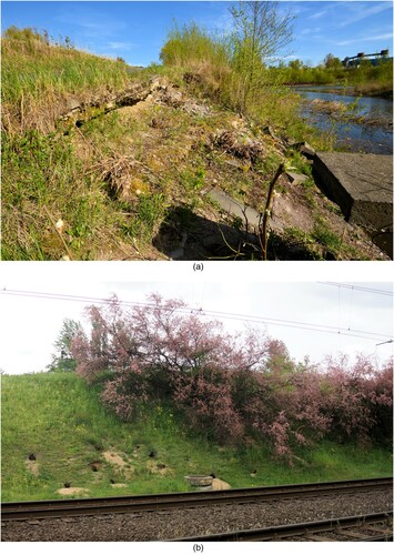
The geological inventory carried out in Poznań registered several currently inactive landslides and identified areas at risk from mass movement (CitationPIG-PIB, 2019b; CitationTroć, Citation2010). The designated areas are associated with the slopes of tunnel valleys and river valleys (around Lake Kierskie and the banks of the Cybina River), where there are significant elevation differences, high slope gradients (locally up to 16°), and substrate geological structures conducive to mass movement (Main Map). The highest risk of mass movement occurs along the Warta River valley. There, layers of Neogene clay at a depth of 6–10 m below ground dip towards the valley and are overlain by glacial tills, colluvial sands, and anthropogenic deposits. Groundwater outflows from the sandy layers, suffosion processes, and the presence of the Neogene clay layers, the upper part of which may constitute a slip surface, render these areas susceptible to shallow, transitional slides. In addition to the geological conditions, the loading of the slope by human-built structures contributes to the disturbance of the substrate (A). Areas at risk of mass movement due to human activity were also identified. One such area is the A2 motorway in the southern part of Poznań. Landslides may occur on both sides of the road excavations, which were made in glacial till and covered with sandy embankments. Minor landslides were also observed along the Poznań Fast Tram route which follows a 6-m-deep excavation for a distance of 8 km. There, mass movement can be initiated from suffosion and animal burrowing (B), e.g. by foxes (Vulpes vulpes; CitationMania, Citation2008).
Figure 2. Mass movement hazards in Poznań: A – The slopes of the Warta River valley in the inland port destroyed by a landslide (photo M. Makohonienko); B – foxes burrowing on the excavation slopes of the Poznań Fast Tram route (photo Zb. Zwoliński).
4.3. Flash flood, urban flash flood and soil erosion geohazards (surface runoff)
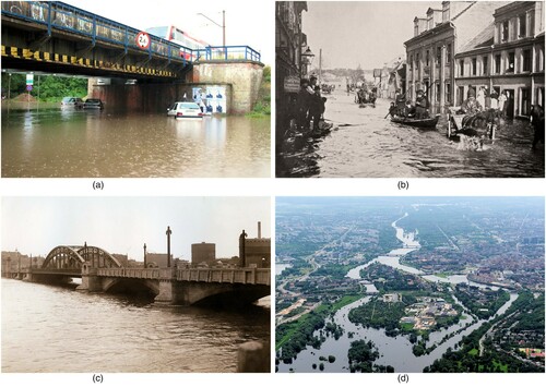
The Catalogue of Local Flash Floods (CitationOstrowski et al., Citation2012) and the Catalogue of Torrential Precipitation (CitationLorenc et al., Citation2012) indicate that, in the years 1971–2015, there were 20 urban flash flood events in Poznań. The valleys of tributaries of the Warta River (mainly Bogdanka River, Cybina River, Główna River and Junikowski Stream) are most susceptible to flash flooding (CitationJawgiel, Citation2016). The areas of higher flood risk in Poznań are mainly excluded from urban development. Except for some areas with a few residential buildings, other flooding-prone areas were classified as green areas with special development conditions (e.g. allotments, parks, and other landscaped green areas). In addition to the varied topography and the sealing of part of the catchment area, other causes of flooding include the small diameter of culverts, pipelines, and clean span, and the blocking of drainage facilities by debris. There are several areas in Poznań where the stormwater drainage infrastructure does not function effectively (A). These areas are mainly located in endorheic basins and tunnels on the city’s left bank (CitationJawgiel, Citation2016). The online geoportal of the CitationPoznań Flash Flood Project (2019) permits the ongoing analysis of inundation sites in the city.
Figure 3. Hydrological hazards in Poznań: A – Niepodległości Avenue during urban flash flood in 2019 (photo K. Jawgiel); B – Chwaliszewo Street during the disaster flood of the Warta River in April 1888 (from the Wielkopolska Museum of Independence); C – One of the bridges over the Warta river during the flood in April 1924 (from the City Heritage Conservator’s Office in Poznan); D – the Warta River during the 2010 flood (photo M. Kaczmarczyk, from Cyryl – Digital Local Repository).
Urban flash floods can inundate buildings in the urban environment, particularly in densely populated areas. They are triggered by torrential precipitation in areas of limited ground absorption capacity and insufficient or outdated drainage/stormwater infrastructure. Urban flash floods are associated with cascading urban geohazards, such as surface runoff and sheet wash. In various parts of the city, puddles and ponds may form in the streets and on sealed surfaces (A), and rapid runoff may take place in areas of diversified relief. This increases the risk of flooding at places where runoff accumulates, and initiates water erosion on the slopes.
In the years 1961–2000, surface runoff made up approximately 10% of the water budget in Poznań’s urban catchments. In catchments with a high ratio of built-up areas (e.g. Bogdanka and Junikowski streams), this value reached 13–15% (CitationGraf & Jawgiel, Citation2018). Analysis of the relationship between surface runoff and the soil of the drained surface (in undeveloped zones) showed that surface runoff is higher on poorly permeable clay soils (i.e. silty, silty-loam, and sandy-silty clays; CitationChmal, Citation1996). In Poznań, soil erosion may occur on biologically and hydrologically active surfaces with slope gradient over 2° – especially over 5° (Main Map). Such areas include the slopes of the Bogdanka and Junikowski streams valleys and the Warta River floodplain (B), which can generate surface runoff (CitationGraf, Citation2014). During precipitation and rapid snow melting, concentrated surface runoff on impervious surfaces (such as pavements) adjacent to exposed loose soils can cause severe soil erosion.
4.4. Wind erosion geohazards
Wind erosion results from several co-occurring factors. Favourable conditions include a dry, sandy or dusty substrate, no vegetation cover, and wind speed exceeding the threshold value for aeolian transport (usually above 3–10 m s−1; CitationLópez, Citation1998). Due to the high roughness of the ground in the city, the wind loses its strength, and the threat of aeolian activity concerns scattered suburbs and arable land (D). In Poznan, strong winds, of speeds above 10 m s−1, are recorded for approximately 40 days a year (CitationBednorz & Tomczyk, Citation2020), while very strong winds, of speeds exceeding 17 m s−1, occur for seven days a year on average (Citation44MPA, 2019). Within Poznań’s city limits, the areas potentially susceptible to aeolian erosion cover 3.1% of the city’s area. On the agricultural land that lies within the city limits (SE, SW, NW, and NE parts of Poznań, D: codes 2.1.1, 2.3.1, 2.4.2, 2.4.3), with loose podzolic and brown soils on sandy or clayey-sandy bedrock, aeolian processes intensify in the early spring (before vegetation growth), autumn (after the ploughing period), and winter (niveo-aeolian processes). Aeolian soil erosion is also triggered by large-scale urban construction works that involve the rapid removal of the vegetation cover and soil desiccation of large land surfaces. The neglect or overuse of public recreation and gathering places also makes their ground susceptible to wind erosion. Wind erosion geohazards intensified in the twenty-first century. Increasingly, deep cyclones of hurricane speed that may exceed 120 km h−1, pass suddenly through Poznań throughout the year, damaging grey and green infrastructure by tearing off the roofs of buildings, breaking trees and branches and damaging energy lines.
4.5. Flood geohazards
The primary source of flood hazards in Poznań is the Warta River and its tributaries. The city has been subject to numerous floods in its history (CitationKaniecki, Citation2004). In the years 1501–1903, 69 floods occurred in Poznań (once every six years on average). After the great floods of 1888 (B) and 1889, flood embankments were constructed in the downtown areas of Chwaliszewo and Ostrów Tumski, on the left and right riverbanks, respectively. Further floods in the twentieth century CE necessitated the extension of the embankments. Poznań is protected from floodwater up to the level of about 58 m a.s.l. The last great flood in Poznań was in 1924 (C). Since 1986, when the Jeziorsko artificial retention reservoir (42.3 km²), in the middle of the Warta River course (about 260 km upstream from Poznań), became operational, the flood risk in Poznań has decreased. High floodwater levels in the city are associated with discharge above 400 m3 s−1 (CitationWZKiB, 2015), and result in floodplain inundation. Recently, such high discharge events on the Warta River occurred in 2010 (D) and 2011.
Studies and strategic documents (CitationWZKiB, 2015) indicate that, due to the city’s geographical location and geomorphological setting, the operation of the Jeziorsko retention reservoir, and the presence of flood embankments and hydrotechnical devices (polders and bypass channels), Poznań is currently at moderate risk from river floods. The areas of higher flood risk are mainly those excluded from urban development (Main Map). The remaining areas exposed to flooding are classified as green areas with special development conditions (e.g. allotments, parks, and other landscaped green areas). With the current demographic condition of the city, a flood event with a probability of 0.2% would place 690 people at risk; an event with a probability of 1% would threaten 202 people; and one with a probability of 10% would threaten 131 people (CitationPMP, 2015). Maintaining the current land use in areas particularly at risk of flooding, such as riverside boulevards, walking areas, and recreational areas with bicycle paths, without introducing large buildings will ensure the safety of Poznań’s residents; at the same time, this will bring the river valley closer to the inhabitants of Poznań.
5. Conclusions
Geohazards triggered by climate change intensified at the turn of the twenty-first century. Our research provides new information on the spatial distribution of mass movement, flooding, and wind erosion geohazards in the city of Poznań, Poland (Main Map). This information can be useful, even for planners, to identify areas that require remedial operations and/or further, more detailed study.
In most parts of Poznań, the level of geohazard threat to the inhabitants is assessed as medium to low on a 4-point scale. Most of the city’s buildings are located outside the floodplain. This, together with the presence of flood embankments and a retention reservoir upstream of Poznań, protects most buildings from floods. Flooding occurs when the Warta River water level rises, but this mainly affects wastelands or green areas. Flooding due to torrential rainfall also occurs in agricultural areas or wastelands and does not directly threaten Poznań’s inhabitants. Inundation during urban flash floods occurs locally at faulty sewage receptors. The risk from gravitational mass movement is limited to the slopes of the Warta River valley or tunnel valleys occupied by the Warta’s tributaries and lakes. Small-scale mass movements have taken place along transportation lines that run in deep trenches and earth embankments (including a motorway and a speed tram line). During periods of drought, areas used for agriculture (however, gradually limited in the city landscape), are subjected to aeolian soil erosion before the growing season.
In recent years, the most significant damage in Poznań has been caused by high-speed cyclonic winds accompanied by torrential rain. On the one hand, Poznań suffers from a shortage of rainwater because it has one of the lowest values of annual rainfall in Poland. On the other hand, the asphalt, concrete, and pavement tile cover over a large part of the city’s ground forces much of the rainwater to run off quickly during each rainfall. In Poznań, the development of local retention basins, care for the valleys of small watercourses and water reservoirs, and the reduction of concrete and asphalt surfaces could have positive effects on the city’s water cycle. Poznań’s inhabitants should be considered comparatively safe from geohazards. This safety should be reinforced furtherly by adaptation measures to climate change, including maintenance and the development of integrated blue–green infrastructure.
This study did not consider extreme weather events such as heatwaves, extremely hot days, rainstorms, lightning/thunderstorm, droughts, severe winds, and fog, as we focused on selected geohazards only. Nevertheless, the intensification of these phenomena is posing an urgent research challenge.
Software
Saga GIS Software v. 7.0 (Saga Development Team, 2021); GRASS GIS (Grass Development Team, 2021) with r.stream extensions; QGIS 3.18.
Main_Map.pdf
Download PDF (12.4 MB)Acknowledgements
The authors wish to thank the Head Office of Geodesy and Cartography for providing the topographic data and digital elevation model used for the geomorphological investigations. The Corine Land Cover 2018 project in Poland was carried out by the Institute of Geodesy and Cartography and financed by the European Union. The results of the project were obtained from the website of the Chief Inspectorate of Environmental Protection clc.gios.gov.pl. The authors gratefully acknowledge the financial support of the Faculty of Geographical and Geological Sciences and the Initiative of Excellence – Research University (project no 012/08/POB1/0006) at Adam Mickiewicz University in Poznań. We would like to take this opportunity to acknowledge the time and effort devoted by anonymous reviewers to improving the quality of this paper.
Disclosure statement
No potential conflict of interest was reported by the author(s).
Data availability statement
The data that support the findings of this study are available from the corresponding author, [MM], upon reasonable request.
Additional information
Funding
Related Research Data
References
- 44MPA [Miejskie Plany Adaptacji]. (2019). Plan adaptacji do zmian klimatu Miasta Poznania do roku 2030. Ministerstwo Środowiska.
- Al-Kouri, O., Al-Fugara, A., Al-Rawashdeh, S., Sadoun, B., & Pradhan, B. (2013). Geospatial modeling for sinkholes hazard map based on GIS & RS data. Journal of Geographic Information System, 5(6), 584–592. https://doi.org/10.4236/jgis.2013.56055
- Araźny, A., Przybylak, R., Vizi, Z., Kejna, M., Maszewski, R., & Uscka-Kowalkowska, J. (2007). Mean and extreme wind velocities in Central Europe 1951–2005 (on the basis of data from NCEP/NCAR reanalysis project). Geographia Polonica, 80(2), 69–78.
- Bartkowski, T. (1957). Rozwój polodowcowej sieci hydrograficznej w Wielkopolsce Środkowej. Zeszyty Naukowe UAM w Poznaniu. Geografia, 8(1), 3–79.
- Bednorz, E., & Tomczyk, A. M. (2020). Najważniejsze cechy klimatu Wielkopolski. In A. Choiński (Ed.), Wody wielkopolski (pp. 71–92). Wydawnictwo Naukowe UAM.
- Böhner, J., & Antonić, O. (2009). Land-surface parameters specific to topo-climatology. In T. Hengl, H. Reuter (Eds.), Geomorphometry – concepts, software, applications. Developments in Soil Science, 33, 195–226. https://doi.org/10.1016/S0166-2481(08)00008-1
- Böhner, J., & Selige, T. (2006). Spatial prediction of soil attributes using terrain analysis and climate regionalization. In J. Böhner, K.R. McCloy, J. Strobl (Eds.), SAGA–analyses and modelling applications. Göttinger Geographische Abhandlungen, 115, 13–27.
- Bollati, I., Coratza, P., Giardino, M., Laureti, L., Leonelli, G., Panizza, M., Panizza, V., Pelfini, M., Piacente, S., Pica, A., Russo, F., & Zerboni, A. (2015). Directions in geoheritage studies: Suggestions from the Italian geomorphological community. In G. Lollino, D. Giordan, C. Marunteanu, B. Christaras, I. Yoshinori, & C. Margottini (Eds.), Engineering geology for society and territory, vol. 8 ‘preservation of cultural heritage’ (pp. 213–217). Springer.
- Brandolini, P., Cappadonia, C. H., Luberti, G. M., Donadio, C., Stamatopoulos, L., Di Maggio, C., Faccini, F., Stanislao, C., Vergari, F., Paliaga, G., Agnesi, V., Alevizos, G., & Del Monte, M. (2020). Geomorphology of the anthropocene in mediterranean urban areas. Progress in Physical Geography: Earth and Environment, 44(4), 461–494. https://doi.org/10.1177/0309133319881108
- Brandolini, F., Cremaschi, M., & Pelfini, M. (2019). Estimating the potential of archaeo-historical data in the definition of geomorphosites and geo-educational itineraries in the central Po plain (N Italy). Geoheritage, 11(4), 1371–1396. https://doi.org/10.1007/s12371-019-00370-5
- Capes, R., & Teeuw, R. (2017). On safe ground? Analysis of European urban geohazards using satellite radar interferometry. International Journal of Applied Earth Observation and Geoinformation, 58, 74–85. https://doi.org/10.1016/j.jag.2017.01.010
- Carbon Disclosure Project (CDP). (2021). Cities at risk: dealing with the pressures of climate change. Online: Retrieved May 6, 2021, from https://www.cdp.net/en/research/global-reports/cities-at-risk
- Chaminé, H. I., Teixeira, J., Freitas, L., Pires, A., Silva, R. S., Pinho, T., Monteiro, R., Costa, A. L., Abreu, T., Trigo, J. F., Afonso, M. J., & Carvalho, J. M. (2016). From engineering geosciences mapping towards sustainable urban planning. European Geologist Journal, 41, Online: Retrieved October 28, 2019, from https://eurogeologists.eu/european-geologist-journal-41-from-engineering-geosciences-mapping-towards-sustainable-urban-planning/
- Chmal, R. (1996). Szczegółowa Mapa Geologiczna Polska 1:50,000, arkusz 471 Poznań, PIG.
- Cigna, F., Jordan, H., Bateson, L., Mccormack, H., & Roberts, C. (2015). Natural and anthropogenic geohazards in greater London observed from geological and ERS-1/2 and ENVISAT persistent scatterers ground motion data: Results from the EC FP7-SPACE PanGeo project. Pure and Applied Geophysics, 172(11), 2965–2995. https://doi.org/10.1007/s00024-014-0927-3
- Contreras, D., Chamorro, A., & Wilkinson, S. (2020). Review article: The spatial dimension in the assessment of urban socio-economic vulnerability related to geohazards. Natural Hazards and Earth System Sciences, 20(6), 1663–1687. https://doi.org/10.5194/nhess-20-1663-2020
- Dąbrowski, A. (2020). Wpływ krajobrazu na atrakcyjność obszarów mieszkalnych w Poznaniu. Bogucki Wydawnictwo Naukowe. Studia i Prace z Geografii, 87.
- Dąbrowski, S., Trzeciakowska, M., & Straburzyńska, R. (2000). Mapa Hydrogeologiczna Polski w skali 1:50 000, 471- POZNAN (N-33-130-D), J. Górski (Ed.), PIG.
- Desmet, P. J. J., & Govers, G. (1996). A GIS procedure for automatically calculating the USLE LS factor on topographically complex landscape units. Journal of Soil and Water Conservation, 51(5), 427–433.
- Di Salvo, C., Ciotoli, G., Pennica, F., & Cavinato, G. P. (2017). Pluvial flood hazard in the city of Rome (Italy). Journal of Maps, 13(2), 545–553. https://doi.org/10.1080/17445647.2017.1333968
- Dragićević, S., Novković, I., Carević, I., Ţivković, N., & Tošić, R. (2011). Geohazard assessment in the Eastern Serbia. Forum Geographic, 10(1), 10–19. https://doi.org/10.5775/fg.2067-4635.2011.003.i
- Eremina, O., Kozliakova, I., Anisimova, N., & Kozhevnikova, I. (2018). Assessment of exogenous geological hazards in Moscow, Russia. Journal of Nepal Geological Society, 55(Sp. Issue), 133–140. https://doi.org/10.3126/jngs.v55i1.22802
- European Geological Data Infrastructure (EGDI). (2019). PanGeo. Online: Retrieved October 28, 2019, from https://www.europe-geology.eu/pangeo/
- Faccini, F., Giardino, M., Paliaga, G., Perotti, L., & Brandolini, P. (2020). Urban geomorphology of Genoa old city (Italy). Journal of Maps, 1–14. https://doi.org/10.1080/17445647.2020.1777214
- Fenta, A. A., Tsunekawa, A., Haregeweyn, N., Poesen, J., Tsubo, M., Borrelli, P., Panagos, P., Vanmaercke, M., Broeckx, J., Yasuda, H., Kawai, T., & Kurosaki, Y. (2020). Land susceptibility to water and wind erosion risks in the East Africa region. Science of the Total Environment, 703, 135016. https://doi.org/10.1016/j.scitotenv.2019.135016
- Fryirs, K. (2016). River sensitivity: A lost foundation concept in fluvial geomorphology. Earth Surface Processes and Landforms, 42(1), 55–70. https://doi.org/10.1002/esp.3940
- Galderisi, A., & Ferrara, F. F. (2012). Enhancing urban Resilience in face of climate change. Journal of Land Use, Mobility and Environment, 5(2), 69–88. https://doi.org/10.6092/1970-9870/936
- Gibbs, H. K., & Salmon, J. M. (2015). Mapping the world’s degraded lands. Applied Geography, 57, 12–21. https://doi.org/10.1016/j.apgeog.2014.11.024
- GIOS [Główny Inspektorat Ochrony Przyrody]. (2018). The corine land cover 2018. Online: clc.gios.gov.pl
- Graf, R. (2014). Przestrzenne zróżnicowanie spływu powierzchniowego w zlewniach zurbanizowanych na przykładzie miasta poznania. In T. Ciupa & R. Suligowski (Eds.), Woda w mieście (pp. 59–71). Instytut Geografii Uniwersytetu Jana Kochanowskiego.
- Graf, R., & Jawgiel, K. (2018). The impact of the parameterisation of physiographic features of urbanised catchment areas on the spatial distribution of components of the water balance using the WetSpass model. International Journal of Geo-Information, 7(7), 278. https://doi.org/10.3390/ijgi7070278
- Grimm, N. B., Faeth, S. H., Golubiewski, N. E., Redman, C. L., Wu, J., Bai, X., & Briggs, J. M. (2008). Global change and the ecology of cities. Science, 319(5864), 756–760. https://doi.org/10.1126/science.1150195
- Grivei, A.-C., Taralunga, D. D., Popescu, A., Poncos, V., Toma, S.-A., Teleaga, D., Vijdea, A.-M., Baltres, A., & Cociuba, I. (2018). Multi-layer geohazards information system concept for urban areas – URMA urban mapping. 12th European conference on synthetic aperture radar, 2018, pp. 1–4.
- Grzonka, B., Malinger, A., & Wawrzyniak, M. (2008). Analiza zabezpieczenia przeciwpowodziowego Miasta Poznania ze wskazaniem stref zalewowych dla wód o prawdopodobieństwie wystąpienia p=10% p=1% p=0.5% z wykorzystaniem matematycznego modelu Mike Flood. RZGW. Online: Retrieved May 23, 2021, from https://www.poznan.pl/mim/wos/analiza-zabezpieczenia-przeciwpowodziowego-miasta-poznania,doc,2136/analiza-zabezpieczenia-przeciwpowodziowego,26207.html
- Guerreiro, S. B., Dawson, R. J., Kilsby, C., Lewis, E., & Ford, A. (2018). Future heat-waves, droughts and floods in 571 European cities. Environ. Res. Letter, 13(3), 034009. https://doi.org/10.1088/1748-9326/aaaad3
- GUGiK [Główny Urząd Geodezji i Kartografii]. (2019). Dane PZGiK. Online: Retrieved October 20, 2019, from https://www.gugik.gov.pl/pzgik
- Guzzetti, F., & Team. (2019). DORIS – An advanced downstream service for the detection, mapping, monitoring and forecasting of ground deformations. Online: Retrieved October 28, 2019, from https://www.doris-project.eu/
- Harrison, S., Mighall, T., Stainforth, D. A., Allen, P., Macklin, M., Anderson, E., Knight, J., Mauquoy, D., Passmore, D., Rea, B., Spagnolo, M., & Shannon, S. (2019). Uncertainty in geomorphological responses to climate change. Climatic Change, 156(1-2), 69–86. https://doi.org/10.1007/s10584-019-02520-8
- Hildebrandt-Radke, I. (2016). Środowisko geograficzne Poznania. In M. Kara, M. Makohonienko, & A. Michałowski (Eds.), Przemiany osadnictwa i środowiska przyrodniczego Poznania i okolic od schyłku starożytności do lokacji miasta (pp. 23–46). Bogucki Wydawnictwo Naukowe.
- Hofmann, M., Hoppe, A., Karfunkel, J., & Büchi, A. (2017). GIS-based analysis of geo-resources and geo-hazards for urban areas – the example of the northern periphery of Belo Horizonte (capital of Minas Gerais, Brazil). REM – International Engineering Journal, 70(1), 39–45. https://doi.org/10.1590/0370-44672015700135
- Intergovernmental Panel on Climate Change (IPCC). (2018). Global warming of 1.5°C. Online: Retrieved October 28, 2019, from https://www.ipcc.ch/report/sr15/
- Intergovernmental Panel on Climate Change (IPCC). (2019). Climate change and land. Online: Retrieved October 28, 2019, from https://www.ipcc.ch/report/srccl/
- Jania, J., & Zwoliński, Z. (2011). Ekstremalne zdarzenia meteorologiczne, hydrologiczne i geomorfologiczne w Polsce. Landform Analysis, 15, 51–64.
- Jasiewicz, J., & Metz, M. (2011). A new GRASS GIS toolkit for Hortonian analysis of drainage networks. Computers & Geosciences, 37(8), 1162–1173. https://doi.org/10.1016/j.cageo.2011.03.003
- Jawgiel, K. (2016). Zastosowanie systemu obserwacji VGI w badaniach powodzi błyskawicznych miejskich na przykładzie Poznania. Monografie Komitetu Gospodarki Wodnej PAN, 39, 115–124.
- Kaniecki, A. (2004). Poznań. Dzieje Miasta Wodą Pisane. Cz. I–III. Wydawnictwo PTPN.
- Kaniecki, A. (2013). Wpływ antropopresji na przemiany środowiskowe w dolinie Warty w Poznaniu. Landform Analysis, 24, 23–34. https://doi.org/10.12657/landfana.024.003
- Kaphle, K. P., Rimal, L. N., Duvadi, A. K., Piya, B., & Nepali, D. (2007). Geohazards and environmental degradation in some of the urban areas of Nepal. Journal of Nepal Geological Society, 36(1), 23.
- Knight, J., & Harrison, S. (2012). Evaluating the impacts of global warming on geomorphological systems. AMBIO, 41(2), 206–210. https://doi.org/10.1007/s13280-011-0178-9
- Knight, J., & Harrison, S. (2013). The impacts of climate change on terrestrial Earth surface systems. Nature Climate Change, 3(1), 24–29. https://doi.org/10.1007/s13280-011-0178-9
- Kóčka-Krenz, H. (2015). Proces formowania się państwa Piastów. Folia Praehistorica Posnaniensia, 20, 205–218. https://doi.org/10.14746/fpp.2015.20.12
- Kolendowicz, L., Czernecki, B., Półrolniczak, M., Taszarek, M., Tomczyk, A. M., & Szyga-Pluta, K. (2019). Homogenization of air temperature and its long-term trends in Poznań (Poland) for the period 1848–2016. Theoretical and Applied Climatology, 136(3-4), 1357–1370. https://doi.org/10.1007/s00704-018-2560-z
- Komputerowa Mapa Podziału Hydrograficznego Polski (KMPHP). (2004). IMGW, Ministerstwo Środowiska.
- Kożuchowski, K., & Żmudzka, E. (2003). 100-year series of areally averaged temperatures and precipitation totals in Poland. Acta universitatis wratislaviensis, 2542. Studia Geograficzne, 75, 116–122.
- Kundzewicz, Z. (2008). Konsekwencje globalnych zmian klimatu. Nauka, 1, 103–118.
- Kusky, T. M., Ghulam, A., Lu, W., Jianguo, L., Zhongquan, L., & Xiao, C. (2010). Focusing seismic energy along faults through time-variable rupture modes: Wenchuan earthquake, China. Journal of Earth Science, 21(6), 910–922. https://doi.org/10.1007/s12583-010-0144-7
- Lane, S. N. (2013). 21st century climate change: Where has all the geomorphology gone? Earth Surface Processes and Landforms, 38(1), 106–110. https://doi.org/10.1002/esp.3362
- López, M. V. (1998). Wind erosion in agricultural soils: An example of limited supply of particles available for erosion. Catena, 33(1), 17–28. https://doi.org/10.1016/S0341-8162(98)00064-2
- Lorenc, H. (2005). Atlas klimatu Polski. Instytut Meteorologii i Gospodarki Wodnej.
- Lorenc, H., Cebulak, E., Głowicki, B., & Kowalewski, M. (2012). Struktura występowania intensywnych opadów deszczu powodujących zagrożenie dla społeczeństwa, środowiska i gospodarki Polski. In H. Lorenc (Ed.), Klęski żywiołowe a bezpieczeństwo wewnętrzne kraju (pp. 7–32). Instytut Meteorologii i Gospodarki Wodnej − Państwowy Instytut Badawczy.
- Lyu, H.-M., Shen, J. S., & Arulrajah, A. (2018). Assessment of geohazards and preventative countermeasures using AHP incorporated with GIS in Lanzhou, China. Sustainability, 10(304), 1–21. https://doi.org/10.3390/su10020304
- Makohonienko, M., Kara, M., Hiledbrandt-Radke, I., Jasiewicz, J., Antczak-Górka, B., & Michałowski, A. (2016). Środowiskowe uwarunkowania lokalizacji osadnictwa pra- i protohistorycznego (głównie wczesnośredniowiecznego) na obszarze obecnego Poznania w świetle źródeł archeologicznych – dyskusja wybranych zagadnień. In M. Kara, M. Makohonienko, & A. Michałowski (Eds.), Przemiany osadnictwa i środowiska przyrodniczego Poznania i okolic od schyłku starożytności do lokacji miasta (pp. 257–294). Bogucki Wydawnictwo Naukowe.
- Mandarino, A., Faccini, F., Terrone, M., & Paliaga, G. (2021). Anthropogenic landforms and geo-hydrological hazards of the Bisagno Stream catchment (Liguria, Italy). Journal of Maps, 17(3), 122–135. https://doi.org/10.1080/17445647.2020.1866704
- Mania, W. (2008). Trasa szybkiego tramwaju jako element systemu przyrodniczego miasta. Badania Fizjograficzne nad Polską Zachodnią, Seria A- Geografia Fizyczna, 59, 121–131.
- Mateos, R. M., Herrera, G., García-Davalillo, J. C., Grandjean, G., Poyiadji, E., Maftei, R., Filipciuc, T.-C., Auflič, M. J., Jez, J., Podolszki, L., Trigila, A., Comerci, V., Raetzo, H., Kociu, A., Przyłucka, M., Kułak, M., Laskowicz, I., Sheehy, M., Kopackova, V., … Sandić, C. (2017). Integration of geohazards into urban and land-use planning. Towards a landslide directive. The EuroGeoSurveys questionnaire. In M. Mikos, B. Tiwari, Y. Yin, & K. Sassa (Eds.), Advancing culture of living with landslides. World landslide forum 2017 (pp. 1067–1072). Springer.
- McCall, G.J.H. (1998). Geohazards and the urban environment. Engineering Geology, Special Publications, 15, 309-318. https://doi.org/10.1144/GSL.ENG.1998.015.01.31
- Monserrat, O., & Barra, A. (2019). Geohazard impact assessment for urban areas. Online: Retrieved October 28, 2019, from https://u-geohaz.cttc.cat/
- Naylor, L. A., Spencer, T., Lane, S. N., Darby, S. E., Magilligan, F. J., Macklin, M. G., & Möller, I. (2017). Stormy geomorphology: Geomorphic contributions in an age of climate extremes. Earth Surface Processes and Landforms, 42(1), 166–190. https://doi.org/10.1002/esp.4062
- Nicu, I. C. (2017). Frequency ratio and GIS-based evaluation of landslide susceptibility applied to cultural heritage assessment. Journal of Cultural Heritage, 28, 172–176. https://doi.org/10.1016/j.culher.2017.06.002
- Ostrowski, J., Czarnecka, H., Głowacka, B., Krupa-Marchlewska, J., Zaniewska, M., Sasim, M., Moskwiński, T., & Dobrowolski, A. (2012). Nagłe powodzie lokalne (flash flood) w Polsce i skala ich zagrożeń. In H. Lorenc (Ed.), Klęski żywiołowe a bezpieczeństwo wewnętrzne kraju (pp. 123–149). Instytut Meteorologii i Gospodarki Wodnej − Państwowy Instytut Badawczy.
- Paliaga, G., Luino, F., Turconi, L., & Faccini, F. (2019). Inventory of geo-hydrological phenomena in Genova municipality (NW Italy). Journal of Maps, 15(2), 28–37. https://doi.org/10.1080/17445647.2018.1535454
- Państwowy Instytut Geologiczny – Państwowy Instytut Badawczy (PIG-PIB). (2019a). Projekt System Osłony Przeciwosuwiskowej. Online: Retrieved October 28, 2019, from https://geoportal.pgi.gov.pl/SOPO/aplikacja
- Państwowy Instytut Geologiczny – Państwowy Instytut Badawczy (PIG-PIB). (2019b). Geozagrożenia. Online: Retrieved October 28, 2019, from https://cbdgportal.pgi.gov.pl/geozagrozenia/
- Pitidis, V., Tapete, D., Coaffee, J., Kapetas, L., & Porto de Albuquerque, J. (2018). Understanding the implementation challenges of urban Resilience policies: Investigating the influence of urban geological risk in Thessaloniki, Greece. Sustainability, 10(10), 3573. https://doi.org/10.3390/su10103573
- Poznań Flash Flood Project. Online: Retrieved May 26, 2021, from https://hydrolog-flashflood.home.amu.edu.pl/
- Prezydent Miasta Poznania (PMP). (2014). Studium uwarunkowań i kierunków zagospodarowania przestrzennego miasta Poznania. Prezydent Miasta Poznania.
- Prezydent Miasta Poznania (PMP). (2015). Plan operacyjny ochrony przed powodzią dla miasta Poznania. Prezydent Miasta Poznania.
- Reynard, E., Pica, A., & Coratza, P. (2017). Urban geomorphological heritage. An Overview. Quaestiones Geographicae, 36(3), 7–20. https://doi.org/10.1515/quageo-2017-0022
- Rotnicki, K. (2009). Identyfikacja, wiek i przyczyny holoceńskiej ingresji i regresji bałtyku na polskim wybrzeżu środkowym. Wyd. SPN, Bogucki Wyd. Nauk., Poznań.
- Smith, G. J., & Rosenbaum, M. S. (1998). Graphical methods for hazard mapping and evaluation. In J.G. Maund, M. Eddleston (Eds.), Geohazards in Engineering geology. Geological Society Engineering Geology Special Publication, 15(1), 215–220. https://doi.org/10.1144/GSL.ENG.1998.015.01.22
- Spencer, T., Colombier, M., Sartor, O., Garg, A., Tiwari, V., Burton, J., Caetano, T., Green, F., Teng, F., & Wiseman, J. (2018). The 1.5°C target and coal sector transition: At the limits of societal feasibility. Climate Policy, 18(3), 335–331. https://doi.org/10.1080/14693062.2017.1386540
- Spencer, T., & Lane, S. N. (2017). Reflections on the IPCC and global change science: Time for a more (physical) geographical tradition. Le Géographe Canadien, 61(1), 124–135. https://doi.org/10.1111/cag.12332
- Terranova, O., Gariano, S. L., Iaquinta, P., Lupiano, V., Rago, V., & Iovine, G. (2018). Examples of application of GASAKe for predicting the occurrence of rainfall-induced landslides in southern Italy. Geosciences, 8(2), 78. https://doi.org/10.3390/geosciences8020078
- Totaro, T., Alberico, I., Di Martire, D., Nunziata, C., & Petrosino, P. (2020). The key role of hazard indices and hotspot in disaster risk management: The case study of Napoli and Pozzuoli municipalities (Southern Italy). Journal of Maps, 16(2), 68–78. https://doi.org/10.1080/17445647.2019.1698472
- Troć, M. (2010). Wstępna dokumentacja dla rejestru terenów zagrożonych ruchami masowymi ziemi na terenie Miasta Poznania. GT Projekt, UM Poznań. Online: Retrieved October 28, 2019, from https://www.poznan.pl/mim/wos/-,p,19964,19966.html
- Urząd Statystyczny w Poznaniu (UswP). (2021). Poznań. Online: Retrieved May 6, 2021, from https://poznan.stat.gov.pl/
- Vecchiotti, F., & Kociu, A. (2013a). Geohazard Summary for Salzburg. Geologische Bundesanstalt für Österreich, Technical Report.
- Vecchiotti, F., & Kociu, A. (2013b). Geohazard Summary for Vienna. Geologische Bundesanstalt für Österreich, Technical Report.
- Western, A. W., Grayson, R. B., Blöschl, G., Willgoose, G. R., & McMahon, T. A. (1999). Observed spatial organization of soil moisture and its relation to terrain indices. Water Resources Research, 35(3), 797–810. https://doi.org/10.1029/1998WR900065
- Wiśniewski, B., Wolski, T., & Musielak, S. (2011). A long-term trend and temporal fluctuations of the sea level at the Polish Baltic coast. Oceanological and Hydrobiological Studies, 40(2), 96–107. https://doi.org/10.2478/s13545-011-0020-9
- Wotchoko, P., Bardintzeff, J.-M., Itiga, Z., Nkouathio, D. G., Guedjeo, C. S., Ngnoupeck, G., Dongmo, A. K., & Wandji, P. (2016). Geohazards (floods and landslides) in the ndop plain, Cameroon volcanic line. Open Geoscience, 8(1), 429–449. https://doi.org/10.1515/geo-2016-0030
- Wrzesiński, D., & Perz, A. (2020). Sieć hydrograficzna Wielkopolski. In A. Choiński (Ed.), Wody wielkopolski (pp. 97–114). Wydawnictwo Naukowe UAM.
- Wydział Zarządzania Kryzysowego i Bezpieczeństwa (WZKiB). (2015). Plan operacyjny ochrony przed powodzią dla miasta Poznania. Prezydent Miasta Poznania.
- Zhao, G. J., Gao, J. F., Tian, P., & Tian, K. (2009). Comparison of two different methods for determining flow direction in catchment hydrological modeling. Water Science and Engineering, 2(4), 1–15. https://doi.org/10.3882/j.issn.1674-2370.2009.04.001
- Ziernicka-Wojtaszek, A. (2006). Zmienność opadów atmosferycznych na obszarze Polski w latach 1971–2000. In J. Trepińska & Z. Olecki (Eds.), Klimatyczne aspekty środowiska geograficznego (pp. 139–148). IGiGP UJ.
- Zwoliński, Z. (2011). Globalne zmiany klimatu i ich implikacje dla rzeźby Polski. Landform Analysis, 15, 5–15.
- Zwoliński, Z., Hildebrandt-Radke, I., Mazurek, M., & Makohonienko, M. (2017). Existing and proposed urban geosites values resulting from geodiversity of Poznań city. Quaestiones Geographicae, 36(3), 125–149. https://doi.org/10.1515/quageo-2017-0031
- Zwoliński, Z., Hildebrandt-Radke, I., Mazurek, M., & Makohonienko, M. (2018). Anthropogeomorphological metamorphosis of an urban area in the postglacial landscape: A case study of Poznań city. In M. J. Thornbush, & C. D. Allen (Eds.), Urban geomorphology. Landforms and processes in cities (pp. 55–77). Elsevier. https://doi.org/10.1016/B978-0-12-811951-8.00004-7
- Zwoliński, Z., Kostrzewski, A., & Stach, A. (2008). Tło geograficzne współczesnej ewolucji rzeźby młodoglacjalnej. In L. Starkel, A. Kostrzewski, A. Kotarba, & K. Krzemień (Eds.), Współczesne przemiany rzeźby Polski (pp. 271–276). Stowarzyszenie Geomorfologów Polskich, IGiGP UJ, IGiPZ PAN.