
ABSTRACT
The Cabuérniga Fault System (CFS) extends for 150 km in E–W trend along the northern divide of the Cantabrian Mountains, near the Cantabrian Sea. This fault system was reactivated several times since the Paleozoic, and displays hydrothermal activity nowadays. We present here a detailed geological map of the whole CFS and six cross-sections distributed along strike, which allowed us to unravel the kinematic history of the individual fault segments comprising the CFS. The current CFS geometry mainly results from the reactivation of E–W Variscan thrusts and NW–SE Late-Variscan strike-slip faults during the Alpine Cycle. Reactivation took place in relation to both Permian and Mesozoic pre-orogenic extension and subsequent Cenozoic shortening. The eastern end of the CFS corresponds to a N–S structure arriving at the Cantabrian coast, while the western edge connects with the E–W trending Llanera fault, leading to an Alpine fault system extending 220 km.
1. Introduction
The Cabuérniga Fault System (CFS) is located in the Cantabrian Mountains, an E–W mountain range of Northern Iberia with elevations over 2600 m (see sketches 1–4 at the bottom of the geological map, ) that are the western extension of the Pyrenees. The CFS also displays a rough E–W direction, extending along 150 km between the localities of Arriondas (Asturias) and Ramales de la Victoria (Cantabria). East from Ramales de la Victoria, this fault system ends in a N–S fault that reaches the sea near the town of Santoña (Cantabria) (Sketch 2). To a great extent, the CFS conforms to the Cabuérniga fault as defined by CitationCarreras Suárez et al. (1978). However, rather than a single structure, there is a complex system of anastomosing faults that we have named ‘Cabuérniga Fault System’. From a geological point of view, the CFS belongs to the Alpine orogenic belt that gave rise on its westernmost termination to the Pyrenean-Cantabrian Mountains (CitationAlonso et al., 1996; CitationMartín-González & Heredia, 2011b; CitationMuñoz, 2002, Citation2019; and references therein). The northern and southern borders of the Cantabrian Mountains correspond to the Cantabrian Sea (Bay of Biscay) and the Cenozoic Duero foreland basin (Sketches 1 and 2). Phanerozoic rocks deformed by compressive and extensional structures developed during the Variscan and Alpine orogenic cycles crop out along this mountain belt.
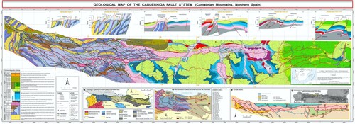
Figure 1. Geological map of the Cabuérniga Fault System (Cantabrian Mountains, Northern Spain).
The interest of the CFS lies on its large extension and long-lasting activity. The system contains inherited Variscan structures, and was active throughout the Alpine Cycle until recent times. Its complexity is evidenced by a wide range of interpretations on its kinematics, including: (i) south-dipping Mesozoic normal fault, which underwent Cenozoic inversion (CitationGarcía-Mondéjar et al., 1986), (ii) south-dipping Mesozoic normal fault cut by a north-dipping Cenozoic reverse fault (CitationGarcía-Espina, 1997) or (iii) vertical Mesozoic normal fault reactivated as strike-slip fault in Cenozoic times (CitationTavani, 2012).
In order to study the complex evolutionary history of this fault system and improve the construction of a coherent kinematic model, a detailed geological map has been carried out, distinguishing: (i) Variscan compressional structures (to improve the legibility of the map, these have been simplified), (ii) Late-Variscan faults and (iii) extensional-compressional structures from the Alpine cycle, indicating the age of the identified reactivations. The map aims the characterisation of the CFS along its complete extension along the Cantabrian Mountains, with special emphasis on the Paleozoic basement, where this fault system has been scarcely studied in previous works. Such characterisation includes also the control exerted by Alpine faults on the deposition of some lithostratigraphic units, the distribution of mineral deposits and the hydrothermal water springs location.
2. Geological setting
The stratigraphic succession of the studied area includes sedimentary rocks from the Cambrian to the Cenozoic, (see the chronostratigraphic scheme on the map). CitationMartín-González and Heredia (2011a, Citation2011b) established a subdivision of the Cantabrian Mountains into two regions: (a) the Vasco-Cantábrica Region to the east, where Mesozoic rocks dominate, and (b) the Astur-Galaica Region to the west, where Paleozoic basement crop out extensively (Sketch 1). The CFS is located in the northern sector of both regions (Sketch 1). In the Vasco-Cantábrica Region, Alpine structures deform the Mesozoic-Cenozoic cover and are easier to recognise than across the Paleozoic outcrops of the Astur-Galaica Region. In the study area, the Variscan structures are Carboniferous in age (CitationMarcos & Pulgar, 1982; CitationMerino-Tomé et al., 2009; CitationPulgar et al., 1999) and belong to the Cantabrian Zone of the Variscan Orogen (CitationJulivert, 1971). This zone represents the fold and thrust belt of the Variscan Orogen in the northwest of Iberian Peninsula and exhibits an arcuate shape convex to the west: the Ibero-Armorican Arc (see CitationWeil, 2006 and references therein) (Sketch 2).
Between the Variscan and Alpine orogenic events, the whole Pyrenean-Cantabrian realm experienced strong lithospheric stretching in the Mesozoic, giving rise to the Bay of Biscay opening and the formation of the North-Iberian Margin (e.g. CitationPedreira et al., 2015 and references therein). During this time, several hyperextended rift basins were developed between the Iberian subplate and the European plate (CitationRoca et al., 2011; CitationTeixell et al., 2018; CitationTugend et al., 2014; CitationVergés & García-Senz, 2001). One of the most subsiding extensional basins of this domain was the Basque-Cantabrian Basin (e.g. CitationÁbalos, 2016; CitationMiró et al., 2020; CitationQuintana et al., 2015; CitationRat, 1988), later incorporated to the orogenic building (Vasco-Cantabrica Region, CitationMartín-González & Heredia, 2011a, Citation2011b). The CFS had a relevant role in this extensional period at the beginning of the Alpine cycle and was reactivated later, during the compressional deformation.
The CFS affects both Paleozoic rocks, already deformed during the Variscan Cycle (lower Cambrian-lowest Permian) and those of the Permian-Mesozoic and Cenozoic (lower Permian-upper Eocene). The Paleozoic rocks in the study area belong to three tectonostratigraphic units of the Cantabrian Zone of the Variscan Orogen (Sketch 2). These units differ on their Carboniferous synorogenic successions (CitationColmenero et al., 2002) and are the following:
The Bodón-Ponga Unit (CitationAlonso et al., 2009), which crops out in the NW sector of the study area and exhibits a Carboniferous succession (up to 3500 m thick) composed of interbedded siliciclastic and carbonate sedimentary rocks, the latter prevailing northwards.
The Picos de Europa Unit (CitationJulivert, 1971), situated south and east from the former unit, covering most of the map and exhibiting a Carboniferous succession (up to 2100 m thick) eminently formed by carbonate rocks. Even though CitationAlonso et al. (2009) included this unit within the Bodón-Ponga Unit, it is considered separately in this work, since its abundance of massive limestones also results in a very distinctive morphology in the Cantabrian Mountains.
The Pisuerga-Carrión Unit (CitationJulivert, 1971; CitationPérez-Estaún et al., 1988), situated south from the Picos de Europa Unit, it is present only on a small sector of the map, where its Carboniferous succession (up to 2000 m thick) is eminently siliciclastic.
The Variscan pre-orogenic succession (mainly middle Cambrian-Early Ordovician) displays a reduced thickness (∼1000 m max.) in the Bodón-Ponga Unit, and it is absent in the southern part of the Picos de Europa Unit and in the Pisuerga-Carrión Unit (CitationAramburu & García-Ramos, 1993). This succession contains several formations that are grouped in the geological map and chronostratigraphic scheme (CD). The Variscan pre- and synorogenic successions were deposited in marine basins, related to the NW passive margin of Gondwana and a peripheral foreland basin, respectively.
The rocks related to the Alpine Cycle can be also grouped in a pre-orogenic and a synorogenic succession. The continental/marine pre-orogenic succession was deposited in the North-Iberian passive margin, is very thick (up to 8000 m) and has a lower Permian-Paleocene age. The Alpine synorogenic succession in the study area is very thin (less than 200 m) and was deposited in a continental foreland basin, although it can reach a thickness of 4000 m more to the south, in the Duero Basin (Sketches 1 and 2). The oldest synorogenic rocks date back to the upper Eocene, in contrast to the Pyrenees where the synorogenic sedimentation start in the later Upper Cretaceous (CitationMuñoz, 2002). The Alpine pre-orogenic sedimentation is largely siliciclastic and mainly continental in its basal part (the Permian-Triassic succession), marine in the Lower and Middle Jurassic (extensive carbonate platform deposits), marine to continental siliciclastic in the Upper Jurassic-Lower Cretaceous and mainly calcareous and marine again in Upper Cretaceous times, although at this age the carbonate platform is more discontinuous (CitationÁbalos, 2016; CitationGarcía-Senz et al., 2019; CitationHeredia et al., 1990; CitationMiró et al., 2020 and references therein).
3. Methods
A geological map at scale 1:25.000 was elaborated, based in previous data and new field data projected on ortophotographies and topographic maps from the Instituto Geográfico Nacional (IGN). This map was subsequently simplified to the broader scale 1:100.000 for publication, preserving the most outstanding cartographic information of the CFS. The map integrates previous data from: (i) published geological maps edited by the Spanish Geological Survey – Instituto Geológico y Minero de España (IGME), including 1:50.000 scale maps from the MAGNA ‘Mapa Geológico Nacional/National Geological Map’ (CitationCarreras Suárez et al., 1974; CitationCarreras Suárez et al., 1978; CitationJulivert et al., 1979; CitationMartínez-García et al., 1984; CitationNavarro & Rodríguez Fernández, 1984; CitationPortero García et al., 1975a, Citation1975b) and the GEODE ‘Mapa Geológico Digital continuo de España/Continuous Digital Geological Map of Spain’: Zona Cantábrica (CitationMerino-Tomé et al., 2019) and Zona Pirineos-Vasco-Cantábrica (CitationRobador Moreno et al., 2019); (ii) ‘Mapa Geológico de Cantabria/Geological Map of Cantabria’ at 1:100.000 scale (CitationHeredia et al., 1990) and several sheets of the more recent ‘Mapa Geológico de Cantabria’ at 1:25.000 scale, elaborated by the IGME in collaboration with the Regional Government of Cantabria (CitationGarcía-Senz & Cañas Fernández, 2013a, Citation2013b; CitationGarcía-Senz & Merino Tomé, 2011; CitationHuerta Carmona, 2009; CitationLarrondo Echevarria et al., 2008; CitationSolé Pont et al., 2008a, Citation2008b, Citation2008c); (iii) geological maps published in scientific journals (CitationÁlvarez-Marrón et al., 1989; CitationMarquínez, 1989); including also (iv) the location of the main mineral deposits and hydrothermal water springs for the study area, obtained from the BDMIN and BDAGUAS databases of the IGME, correcting in some cases these locations with new GPS coordinates. The new geological data were obtained during several fieldwork campaigns focused on the resolution and refinement of the cartographic expression of the CFS. All this information has been digitalised using ArcGis. A specific symbology has been composed, using different colours to describe different fault types and activity periods, and highlighting the Alpine structures, which are represented in red. Finally, for a detailed geometric and structural characterisation of the CFS, six N–S geological cross-sections were produced along the fault system and reproduced on top of the geological map.
4. Description of the structures
The structures of the CFS have been differentiated according to their age, kinematics and orientation. Reactivations of the structures are frequent and occurred in different times, along the entirety of their trace or in segments of favourable orientation. The geometric characteristics and the evolution of the SFC structures over time that are deduced from the geological map are described next.
4.1. Variscan structures
The main Variscan structures are thrusts and related folds (CitationJulivert, 1971; CitationPérez-Estaún et al., 1988) that resulted in a shortening of ∼75% (CitationMerino-Tomé et al., 2009). This tight imbricate system show variable orientations due to its location near the core of the Ibero-Armorican Arc (Sketch 2), and display differing tectonic transport directions and emplacement age. Accordingly, in the Bodón-Ponga Unit, the thrusts were emplaced in the upper Moscovian-Kasimovian (CitationHeredia, 1998; CitationRodríguez-Fernández & Heredia, 1987), exhibit a general strike direction N-S that changes to E-W northwards, and record a tectonic transport direction toward the east (CitationWeil, 2006). In the Picos de Europa Unit, the thrusts are Kasimovian-Gzhelian in age (CitationMerino-Tomé et al., 2009), display strikes ranging ENE-WSW in their western portion to E-W in their eastern part, and present a generalised tectonic transport direction toward the S-SSE (CitationFarias & Heredia, 1994). The latter thrusts accommodated to a great extent the closure of the Ibero-Armorican Arc by the end of the Variscan Orogeny. They also caused the rotation of the thrusts in the Bodón-Ponga Unit from a N-S direction to an E-W orientation in the northern sector of this unit (CitationJulivert & Arboleya, 1986; CitationMerino-Tomé et al., 2009; CitationPérez-Estaún et al., 1988; CitationRodríguez-Fernández & Heredia, 1988; among others) (Sketch 2). Finally, NW–SE strike-slip faults dominate in the fraction of the Pisuerga-Carrión Unit represented in this map.
The Picos de Europa Unit consists in an imbricate thrust system developed in a forward breaking sequence (CitationFarias & Heredia, 1994; CitationMerino-Tomé et al., 2009). In this system, the dominant E-W-trending thrusts represent frontal structures, while those with orientations near N-S (NNE-SSW to NNW-SSE) represent lateral and oblique structures. As a consequence of the stacking of thrusts with listric geometry, these thrusts are nearly vertical to overturned in the northern part of the Unit and dip moderately in the south, as revealed by their sinuous map traces (see geological map and cross-sections I–I’ and II–II’) (CitationMerino-Tomé et al., 2009).
In the Bodón-Ponga Unit, the thrusts become sub-vertical to slightly overturned and present a N–S strike in the proximity of the western contact with the Picos de Europa Unit. This arrangement allowed their reactivation as lateral ramps during the southward emplacement of the Picos de Europa Unit. Evidencing this reactivation, unconformable Kasimovian deposits (CSs), syn-tectonic to the emplacement of the Picos de Europa Unit, are present in the hanging wall of the overturned thrusts of the Bodón-Ponga Unit.
4.2. Late-Variscan faults
Anastomosing strike-slip faults with a NW–SE to NNW–SSE direction cut through the Variscan thrusts accommodating displacements with a main dextral component. Some of these faults reactivated Variscan thrusts, resulting in nearly vertical reverse faults that still present a strike-slip component. These faults, which are sub-vertical, either strongly dipping toward the NE or, more rarely, toward the SW, were formed prior to the Permian deposits and hence they are considered as Late-Variscan faults. Moreover, the post-Variscan Permian deposits contain volcanic intervals in its lower part, whose plutonic counterparts are as old as ∼297 Ma (CitationGallastegui et al., 2004). Taking the aforementioned data into account, it is possible to infer that the development of the Late-Variscan faults comprised a short time span (4–5 Myr) between the Gzhelian (age of the youngest Variscan thrusts), and the lower Asselian (age of the oldest Permian deposits). This age is coincident with that estimated for the end of the Ibero-Armorican Arc closure, suggesting that these faults accommodated the last Variscan compressional stresses (CitationLópez-Gómez et al., 2019; CitationRodríguez-Fernández & Heredia, 1987). The attitude of the Late-Variscan faults in the study area resembles that of the Ventaniella fault, a large Late-Variscan structure (Late-Hercynian according to CitationArthaud & Matte, 1977) that crosscuts the Cantabrian Zone west from the geological map (Sketch 2).
4.3. Alpine structures
We include under the definition of ‘Alpine structures’ those related to the whole Alpine cycle, including the normal and transfer faults formed during the Permian-Mesozoic extensional stages and the high-angle reverse faults, thrusts, folds and lateral structures linked to the development of the Cantabrian Mountains during the Cenozoic. Among the Alpine structures, we therefore, include those related to salt tectonics during the Mesozoic and their reactivation during the Alpine compression (e.g. CitationCámara, 2020; CitationGarcía-Senz et al., 2019 and references therein), represented in the study area by the El Mazo, Cabezón de la Sal, Sarón and Selaya diapirs.
4.3.1. Pre-orogenic extensional structures
They can be recognised because shortening achieved during the Alpine compressional event was moderate at upper crustal levels in this area, with maximum values close to 15% (CitationGarcía-Espina, 1997), although this shortening increases to the north and in depth (CitationGallastegui, 2000; CitationPedreira et al., 2015). The first extensional structures immediately postdated the Variscan Orogeny and formed in response to the final extensional collapse of the belt. These structures resulted from reactivation of Variscan and Late-Variscan faults and controlled the development of the small and isolated lower Permian (Cisuralian) basins extending along E–W and NW–SE preferred directions (CitationLópez-Gómez et al., 2019). Sometimes, the faults controlling the formation of these basins are covered by Triassic deposits, as can be seen in the Deva river gorge, west of the La Hermida village (location in the central part of the map, close to 370.000 UTM line).
After a gap of 30 Myr, a second extensional event is identified in the Middle-Upper Triassic sedimentary record (CitationLópez-Gómez et al., 2019). This event is related to the incipient rifting that led to the opening of the Bay of Biscay and the separation of the Iberian microplate from the Eurasian plate (CitationBoillot et al., 1979; CitationRat, 1988). Usually, the faults related to this period were sealed by Jurassic marine deposits (JM1 on the map), although the base of the Jurassic was occasionally affected. These faults are sometimes spatially associated with subvolcanic basic rocks and controlled the deposition and thickness of the Triassic facies. They show different orientations: (i) E-W normal faults, such as the one controlling the thickness of the ‘Buntsandstein Facies’ (Tb) at the Peña Sagra range (377500-4782500 UTMs); (ii) NW-SE and E-W structures, such as the Aloños and Selaya faults, respectively (ALF and SEF in Sketch 3), which could have controlled the sedimentation of the ‘Keuper Facies’ (Tk) between the localities of Selaya (Pisueña river valley) and Puente Viesgo (Pas river valley), being the outcrops of this unit absent west and south from these faults. (iii) N-S transfer faults, such as the El Mazo fault (approximate map coordinates: 391400-4798000), limiting the westernmost extent of diapirism and outcrops of the Upper Triassic ‘Keuper Facies’.
The last extensional phase took place between the Middle-Upper Jurassic and the Lower Cretaceous (CitationGarcía-Senz et al., 2019; CitationRat, 1988 and references therein). The faults that were active during this time period, are occasionally overlain by Aptian deposits in the western portion of the study area (west of Cueva del Soplao, 385000-4795000 UTMs), whereas they are locally covered by deposits of Albian age in the east part of the map (east of the Rubalcaba fault, RUF in Sketch 3). The strike direction of these structures ranges generally from NW–SE to E–W (matching the directions of main Variscan and Late-Variscan structures), with NE–SW orientations found only to the east of the Rubalcaba fault. The N–S Mesozoic faults are interpreted as transfer faults of this extensional system. Some examples of faults, related to this third extensional event are:
The N–S Cotillo and Besaya transfer faults (COF and BEF on the map, respectively; Sketch 3) led to the Buelna paleohigh, where Jurassic deposits are almost absent and the Lower Cretaceous Pas Group lies directly on top of Triassic deposits.
The NW–SE Tánago fault (TAF in Sketch 3), which allowed a thick accumulation of the Pas Group (PGr on the map) in the NE block.
The south-dipping NE–SW to E–W Valle de Luena fault (VLF in Sketch 3, cross-section VI–VI’) that records an increase in thickness of the Pas Group and Urgonian Complex to the south.
Eastwards, this last extensional period originated various hyperextended rift basins, which were situated between the Iberian microplate and the Eurasian plate (CitationRoca et al., 2011; CitationTeixell et al., 2018; CitationTugend et al., 2014; CitationVergés & García-Senz, 2001 and references therein) and accumulated over 10,000 m of sediments (CitationGarcía-Mondejar, 1989).
Overall, the strikes of the Permian-Mesozoic normal faults are commonly the same as those of the main Variscan structures, evidencing their frequent reactivation. In some cases, overturned Variscan thrusts were also reactivated as south-dipping normal faults this might be the case of the El Saigu thrust between the towns of Tresviso and Las Caldas de Besaya (see cross-sections III–III’ and IV–IV’). On the other hand, Variscan thrusts tilted to dip angles larger than 40–50° commonly were reactivated as north-dipping Permian-Mesozoic normal faults, which are the most abundant.
4.3.2. Contractional structures
The structures related to the Alpine compressional deformation are thrusts and reverse faults, generally dipping to the north, and open folds that are clearly recognised in the Mesozoic cover but are scarce or absent in the more rigid Paleozoic basement (CitationAlonso et al., 1996; CitationPulgar et al., 1999).
In the Paleozoic basement of the western area of the map, it is possible to see how the CFS thrusts developed mainly through the reactivation of previous faults, specifically, Variscan thrusts and/or Alpine normal faults with strike directions close to E-W and dipping toward the north. On the contrary, where the pre-existing structures are vertical or south dipping, they generally appear crosscut by the Alpine thrusts, which developed their own trajectory. Nonetheless, overturned Variscan thrusts occasionally reactivated as backthrusts, a process favoured where they previously reactivated as south-dipping normal faults. This appears to be the case for the Variscan thrusts located north from the El Saigu thrust, around Puentenansa, west from cross-section III–III’. Along the eastern and westernmost sectors of the map, the CFS develops imbricate thrust systems and high-angle reverse faults south from the main trace of the Cabuérniga fault (CAF in Sketch 3).
Frequently, the Late-Variscan faults reactivated as oblique and/or lateral ramps during the Alpine contraction, with an associated uplift of their northeastern block. Accordingly, the number of Alpine thrusts occasionally differs from one side of the Late-Variscan faults to the other (e.g. Cabañes and Mier faults; see geological map and Sketch 3).
Several E–W major (kilometre-scale) folds deform the rocks of the Mesozoic Alpine cover, thus being readily recognisable (see cross-sections III–III’ to VI–VI’). From north to south, the following folds are present, exhibiting reduced lateral continuity and complex geometries:
The Panes synclinorium, north of the El Soplao fault (SOF in Sketch 3), has Cretaceous rocks in its core and is limited to the east by the N–S El Mazo fault (MAF in Sketch 3). East from this fault, the Panes synclinorium is replaced by the Cabezón de la Sal anticlinorium, truncated by a diapir of the same name. Moreover, the El Mazo fault, a normal Triassic fault reactivated in a short segment by the diapir of same name, separates two areas with a different number of thrusts, evidencing its role as a lateral structure during the Alpine shortening.
The Cabuérniga anticline, situated south of the El Soplao fault with Triassic rocks in its core, originated in the frontal ramp of the reverse Cabuérniga fault (CAF in Sketch 3). Eastwards, this anticline leads to a series of folds of smaller amplitude corresponding to the eastern termination of the main thrust-fault imbricate of the CFS.
The Tudanca synclinorium is a kilometric-scale structure located south from the Cabuérniga fault. This fold appears displaced southwards, east from the Buelna paleohigh. This shift is linked to the development of the eastern imbricate thrust/fault system, which almost reaches the southern edge of the map (Sketch 3). Furthermore, this imbricate thrust system also resulted in both the southward displacement of the Cabuérniga anticline and the development of other structures such as the Selaya synclinorium, the Arredondo anticlinorium and the La Sía synclinorium (see cross-section VI–VI’).
Between the Besaya and Pisueña rivers, the main N–S pre-orogenic transfer faults became reactivated as lateral structures also in the course of the Alpine compressional stage. For instance, the Cotillo fault (COF) constitutes the western termination of the eastern imbricate of the CFS. Similarly, the Besaya fault (BEF on the map) represents the eastern end of the Puentenansa backthrust (Sketch 3). At the terminations of the CFS, multiple NW–SE to E–W, north-dipping Alpine pre-orogenic normal faults became reactivated as frontal and oblique ramps during the Alpine compression. Many of those extensional structures, in turn, may represent reactivations of Variscan or Late-Variscan structures (CitationGarcía-Espina, 1997; CitationLópez-Gómez et al., 2019). Such is the case of the Tánago fault (TAF in Sketch 3), which delimits the Puentenansa backthrust in the west and may constitute the southeastern continuation of the Late-Variscan Mier fault (MIF in Sketch 3). East from Ramales de la Victoria, the CFS ends in another N–S transfer fault known as Ramales fault (RAF in Sketch 3).
In the western end, the CFS connects with the Llanera Thrust System (LLF in Sketch 2), which affected Cenozoic deposits formed in the Oviedo-Infiesto syn-orogenic basin in upper Eocene-Oligocene times, during the main pulse of orogenic uplift (CitationAlonso et al., 1996; CitationFillon et al., 2016). A small outcrop of these Cenozoic synorogenic deposits appears in the northern part of the geological map. As a whole, the LLF and the CFS belong to a unique E–W Alpine imbricate thrust system extending along 220 km.
Associated with alpine faults of the CFS, six hydrothermal springs exist within the study area (CitationBaeza et al., 2001). From west to east, they are Fuente Obar, La Hermida, La Brezosa, Las Caldas de Besaya, Puente Viesgo and Alceda (see Main map). The hydrothermal water temperature varies between 65° in La Hermida and 27° in Alceda, then including both hypothermal and hyperthermal springs. The Alceda spring is located within the frontal portion of the eastern imbricate thrust/fault system linked to the CFS. Fuente Obar is coincident with the Late-Variscan San Carlos fault (SCF), while the La Hermida spring lies on the El Saigu thrust, both reactivated in the Alpine cycle. The Caldas de Besaya and Puente Viesgo upwellings are located on Variscan structures reactivated and connected to the CAF.
5. Fault-related mineralisations
Various mineral associations related with faults are present in the study area, including metallic and non-metallic elements (see the legend of the geological map). Mn and Fe ores usually show a sedimentary control, being located at brecciated zones and/or lateritic levels that result from subaerial exposure of carbonate rocks from either the Paleozoic (CUc, CLc in the map), Jurassic (JM1) or Cretaceous (Cru). The location of the Hg mineralisations tends to be associated with Variscan thrusts or lie in their proximity, suggesting a genetic link with these structures. On the contrary, Pb-Zn and F (associated to minor Cu) ore prospects seem mostly related to Alpine structures and/or Late-Variscan faults, either reactivated during the Alpine Cycle or not. However, these prospects are also present in areas relatively far from faults (at least on the surface), either hosted by Paleozoic limestones or Mesozoic units (specially the Urgonian Complex: units UC1 to UC4 in the map). The age of the F ores generally is Upper Triassic (ca. 206 Ma) (CitationSymons et al., 2017), while Pb-Zn deposits mostly date back to the Lower Cretaceous (ca. 112 Ma) (CitationSymons et al., 2015), thus suggesting that their origin was linked to the end of the main Alpine extensional stages recorded in the study area. Besides, the intense dolomitisation found in the limestones of the Picos de Europa Unit could have taken place mostly in Permian times, as in other areas of the Cantabrian Mountains (CitationGasparrini et al., 2006a, Citation2006b), and is linked to Variscan thrusts and Late-Variscan faults, either non reactivated or reactivated during the extensional collapse of the Variscan Orogen.
6. Conclusions
The detailed geological map presented here shows a new and clarifying image of the hitherto poorly known Alpine Cabuérniga Fault System (CFS). The faults associated with the CFS have been mapped over 150 km, through the Variscan Basement and the Alpine cover of northern Cantabrian Mountains, indicating the age and main type of movement for each fault or fault segment (normal, reverse or strike-slip). This map has made it possible to relate the genesis of the structures associated with the CFS with the sedimentation of certain lithostratigraphic units in the studied area, as well as to understand the complex kinematic evolution of these faults, identifying their successive reactivations. The role that each fault or fault segment has played over time provides the necessary framework to understand the relationship between tectonic processes and the different episodes of hydrothermalism and mineralisations that occurred in this part of the Cantabrian Mountains since the end of the Variscan cycle and throughout the entire Alpine cycle
Software
The geological map was originally constructed using Esri ArcGIS 10.5. The final draft was composed using Adobe Illustrator CS6.
TJOM_A_2010612_Supplementary_Material
Download PDF (15 MB)Acknowledgements
Thoughtful reviews by Chris Orton, Berta López-Mir and Gerardo de Vicente greatly helped to improve the geological map and manuscript. We want to thank Gloria Romero Canencia and Luis Fernando Miguel Cabrero, from the IGME Cartographic Edition Cabinet, for the final edition of the geological map.
Disclosure statement
No potential conflict of interest was reported by the author(s).
Data availability statement
The authors confirm that the geological field data supporting the findings of this study are available within the article and its supplementary material.
Additional information
Funding
References
- Ábalos, B. (2016). Geologic map of the Basque-Cantabrian Basin and a new tectonic interpretation of the Basque Arc. International Journal of Earth Sciences, 105(8), 2327–2354. https://doi.org/10.1007/s00531-016-1291-6
- Alonso, J. L., Marcos, A., & Suárez, A. (2009). Paleogeographic inversion resulting from large out of sequence breaching thrusts: The León Fault (Cantabrian Zone, NW Iberia). A new picture of the external Variscan Thrust Belt in the Ibero-Armorican Arc. Geologica Acta, 7(4), 451–473. https://doi.org/10.1111/j.1755-6724.1994.mp7004007.x
- Alonso, J. L., Pulgar, J. A., Carlos, G. R. J., & Barba, P. (1996). Tertiary basins and Alpine tectonics in the Cantanbrian Mountains (NW Spain). In P. F. Friend, & C. J. Dabrio (Eds.), Tertiary basins of Spain. The stratigraphic record of crustal kinematics (pp. 214–227). Cambridge University Press.
- Álvarez-Marrón, J., Heredia, N., & Pérez-Estaún, A. (1989). Mapa geológico de la Región del Ponga. Trabajos de Geología, 18, 127–135. https://reunido.uniovi.es/index.php/TDG/article/view/2862/2727
- Aramburu, C., & García-Ramos, J. C. (1993). La sedimentación Cambro-Ordovícica en la Zona Cantábrica (NO de España). Trabajos de Geología, 19, 45–73. https://reunido.uniovi.es/index.php/TDG/article/view/2869/2734
- Arthaud, F., & Matte, P. (1977). Late Paleozoic strike-slip faulting in Southern Europe and Northern Africa – Result of a right-lateral shear zone between Appalachians and Urals. Geological Society of America Bulletin, 88(9), 1305–1320. https://doi.org/10.1130/0016-7606(1977)88<1305:LPSFIS>2.0.CO;2
- Baeza, J., Cerezuela, M. D., Cuchi, J. A., Duran, J. J., Fernández-Sánchez, J. A., López-Geta, J. A., Moreno-Merino, L., & Rubio-Navas, J. (2001). Las Aguas Minerales de España (pp. 450). Instituto Geológico y Minero de España (IGME).
- Boillot, G., Dupeuble, P. A., & Malod, J. (1979). Subduction and Tectonics on the continental margin off northern Spain. Marine Geology, 32(1–2), 53–70. https://doi.org/10.1016/0025-3227(79)90146-4
- Cámara, P. (2020). Inverted turtle salt anticlines in the Eastern Basque-Cantabrian basin, Spain. Marine and Petroleum Geology, 117, 104358. https://doi.org/10.1016/j.marpetgeo.2020.104358
- Carreras Suárez, F. J., Portero García, J. M., del Olmo Zamora, P., Ramírez del Pozo, J., Aguilar Tomás, M. J., & Tosal Suárez, J. M. (1974). Hoja del Mapa Geológico de España a escala 1: 50.000, n° 58 (Los Corrales de Buelna). In Segunda serie (MAGNA)-Primera Edición (47 pp.). Instituto Geológico y Minero de España.
- Carreras Suárez, F. J., Ramírez del Pozo, J., Aguilar, M. J., & Pujalte, V. (1978). Hoja del Mapa Geológico de España a escala 1:50.000, n° 57 (Cabezón de la Sal). In Segunda serie (MAGNA)-Primera edición (38 pp.). Instituto Geológico y Minero de España.
- Colmenero, J. R., Fernández, L. P., Moreno, C., Bahamonde, J. R., Barba, P., Heredia, N., & González, F. (2002). Carboniferous. In W. Gibbons, & T. Moreno (Eds.), The geology of Spain (pp. 93–116). Geological Society London.
- Farias, P., & Heredia, N. (1994). Geometría y Cinemática de los dúplex de Pambuches (Unidad de Picos de Europa, Zona Cantábrica, NO de España). Revista de la Sociedad Geológica de España, 7(1–2), 113–120. http://www.sociedadgeologica.es/archivos/REV/7(1-2)/Art08.pdf
- Fillon, C., Pedreira, D., van der Beek, P. A., Huismans, R. S., Barbero, L., & Pulgar, J. A. (2016). Alpine exhumation of the central Cantabrian Mountains, Northwest Spain. Tectonics, 35(2), 339–356. https://doi.org/10.1002/2015TC004050
- Gallastegui, G., Suárez, O., & Cuesta, A. (2004). Zona Cantábrica: magmatismo. In J. A. Vera (Ed.), Geología de España (pp. 47–49). Sociedad Geológica de España-Instituto Geológico y Minero de España.
- Gallastegui, J. (2000). Estructura cortical de la Cordillera y margen continental cantábricos: Perfiles ESCI-N. Trabajos de Geología, 22, 234. https://reunido.uniovi.es/index.php/TDG/article/view/2912/2777
- García-Espina, R. (1997). La estructura y evolución tectonoestratigráfica del borde occidental de la Cuenca Vasco-Cantábrica (Cordillera Cantábrica, NO de España) [PhD Thesis, Universidad de Oviedo]. http://hdl.handle.net/10651/16791
- García-Mondejar, J. (1989). Strike-slip subsidenceof the Basque-Cantabrian Basin of Northern Spain and its relationship to Aptian-Albian opening of the Bay of Biscay. In A. J. Tankard, & H. R. Balkwill (Eds.), Extensional tectonics and stratigraphy of the North Atlantic Margins. (pp. 395–409) American Association of Petroleum Geologists, Memoir.
- García-Mondéjar, J., Pujalte, V., & Robles, S. (1986). Características sedimentológicas secuenciales y tectonoestratigráficas del Triásico de Cantabria y norte de Palencia. Cuadernos de Geología Ibérica, 10, 151–172.
- García-Senz, J., & Cañas Fernández, V. (2013a). Hoja del Mapa Geológico 1:25.000 de la Comunidad Autónoma de Cantabria, n° 33-3 San Vicente de La Barquera. IGME-Gobierno de Cantabria.
- García-Senz, J., & Cañas Fernández, V. (2013b). Hoja del Mapa Geológico 1:25.000 de la Comunidad Autónoma de Cantabria, n° 33-4 Comillas. IGME-Gobierno de Cantabria.
- García-Senz, J., & Merino Tomé, O. (2011). Hoja del Mapa Geológico 1:25.000 de la Comunidad Autónoma de Cantabria, n° 51-1 Puentenansa. IGME-Gobierno de Cantabria.
- García-Senz, J., Rosales, I., Robador, I., & Pedrera, A. (2019). The Basque-Cantabrian Rift Basin. In C. Quesada, & J. Oliveira (Eds.), The geology of Iberia: A geodynamic approach. Volume 3: The Alpine cycle. Regional geology reviews (pp. 171–182). Springer Nature. https://doi.org/10.1007/978-3-030-11295-0_5
- Gasparrini, M., Bakker, R. J., & Bechstädt, T. (2006b). Characterization of dolomitizing fluids in the Carboniferous of the Cantabrian Zone (NW Spain): A fluid-inclusion study with Cryo-Raman spectroscopy. Journal of Sedimentary Research, 76(12), 1304–1322. https://doi.org/10.2110/jsr.2006.106
- Gasparrini, M., Bechstädt, T., & Boni, M. (2006a). Massive hydrothermal dolomites in the southwestern Cantabrian Zone (Spain) and their relation to the Late Variscan evolution. Marine and Petroleum Geology, 23(5), 543–568. https://doi.org/10.1016/j.marpetgeo.2006.05.003
- Heredia, N. (1998). Los cabalgamientos del sector suroriental de las Unidades del Ponga y de la Cuenca Carbonífera Central (Zona Cantábrica, NO de España). Trabajos de Geología, 20, 53–127. https://reunido.uniovi.es/index.php/TDG/article/view/2877/2742
- Heredia, N., Robador, A., Rodríguez-Fernández, L. R., & Marquínez, J. (1990). Mapa Geológico de Cantabria. In R. Gomez Ceballos, & M. L. Rodriguez Gonzalez (Eds.), Mapa Geológico-Minero de Cantabria a E. 1:100.000 (pp. 133). ITGE-Diputación Regional de Cantabria.
- Huerta Carmona, J. J. (2009). Hoja del Mapa Geológico 1:25.000 de la Comunidad Autónoma de Cantabria, n° 57-2 Cabezón de la Sal. IGME-Gobierno de Cantabria.
- Julivert, M. (1971). Décollement tectonics in the Hercynian cordillera of NW Spain. American Journal of Science, 270(1), 1–29. https://doi.org/10.2475/ajs.270.1.1
- Julivert, M., & Arboleya, M. L. (1986). Aereal balancing and estimate of aerial reduction in a thin skinned fold and thrust belt (Cantabrian Zone, NW Spain): Constraints on its emplacement mechanisms. Journal of Structural Geology, 8(3–4), 407–414. https://doi.org/10.1016/0191-8141(86)90059-3
- Julivert, M., Navarro, D., & Rodríguez Fernández, L. R. (1979). Hoja del Mapa Geológico de España a escala 1: 50.000, n° 55 (Beleño). In Segunda serie (MAGNA)-Primera Edición (47 pp.). Instituto Geológico y Minero de España.
- Larrondo Echevarria, E., Mediato Arribas, F. F., & Hernainz Huerta, P. P. (2008). Hoja del Mapa Geológico 1:25.000 de la Comunidad Autónoma de Cantabria, n° 34-4 Renedo. IGME-Gobierno de Cantabria.
- López-Gómez, J., Martín-González, F., Heredia, N., de la Horra, R., Barrenecheaa, J. F., Cadenas, P., Juncal, M., Diez, J. B., Borruel-Abadia, V., Pedreira, D., Garcia-Sansegundo, J., Farias, P., Gale, C., Lago, M., Ubide, T., Fernandez-Viejo, G., & Gand, G. (2019). New lithostratigraphy for the Cantabrian Mountains: A common tectono-stratigraphic evolution for the onset of the Alpine cycle in the Pyrenean realm, Spain. Earth-Science Reviews, 188, 249–271. https://doi.org/10.1016/j.earscirev.2018.11.008
- Marcos, A., & Pulgar, J. A. (1982). An approach to the tectonostratigraphic evolution of the Cantabrian Foreland thrust and fold belt, Hercynian Cordillera of NW Spain. Neues Jahrbuch für Geologie und Paläontologie, Abhandlungen, 163(2), 256–260.
- Marquínez, J. (1989). Mapa geológico de la Región del Cuera y los Picos de Europa. Trabajos de Geología, 18, 137–144. https://reunido.uniovi.es/index.php/TDG/article/view/2863/2728
- Martín-González, F., & Heredia, N. (2011a). Complex tectonic and tectonostratigraphic evolution of an Alpine foreland basin: The western Duero Basin and the related Tertiary depressions of the NW Iberian Peninsula. Tectonophysics, 502(1–2), 75–89. https://doi.org/10.1016/j.tecto.2010.03.002
- Martín-González, F., & Heredia, N. (2011b). Geometry, structures and evolution of the western termination of the Alpine-Pyrenean Orogen reliefs (NW Iberian Peninsula). Journal of Iberian Geology, 37(2), 103–120. https://doi.org/10.5209/rev_JIGE.2011.v37.n2.1
- Martínez-García, E., Heredia, N., Navarro, D., & Rodríguez-Fernández, L. R. (1984). Hoja del Mapa Geológico de España a escala 1: 50.000, n° 56 (Carreña de Cabrales). In Segunda serie (MAGNA)-Primera edición (45 pp.). Instituto Geológico y Minero de España.
- Merino-Tomé, O., Suárez Rodríguez, A., & Alonso Alonso, J. L. (2019). Mapa Geológico digital continuo E. 1:50.000, Zona Cantábrica (Zona-1000). In GEODE. Mapa Geológico Digital continuo de España.[on line]. Sistema de Información Geológica Continua: SIGECO. IGME. J. Navas (Eds.). [Consultation year: 2019]. Available in: http://info.igme.es/cartografiadigital/geologica/geodezona.aspx?Id=Z1100
- Merino-Tomé, ÓA, Bahamonde, J. R., Colmenero, J. R., Heredia, N., Villa, E., & Farias, P. (2009). Emplacement of the Cuera and Picos de Europa imbricate system at the core of the Iberian-Armorican arc (Cantabrian zone, north Spain): New precisions concerning the timing of arc closure. Geological Society of America Bulletin, 121(5–6), 729–751. https://doi.org/10.1130/B26366.1
- Miró, J., Muñoz, J. A., Manatschal, G., & Roca, E. (2020). The Basque-Cantabrian Pyrenees: Report of data analysis. Bulletin de la Société Géologique de France, 191(1), 22. https://doi.org/10.1051/bsgf/2020024
- Muñoz, J. A. (2002). The pyrenees. In W. Gibbons, & T. Moreno (Eds.), The geology of Spain (pp. 370–385). The Geological Society of London.
- Muñoz, J. A. (2019). Alpine orogeny: Deformation and structure in the Northern Iberian margin (Pyrenees sl). In C. Quesada & J. T. Oliveira (Eds.), The Geology of Iberia: A geodynamic approach. Volume 3: The alpine cycle. Regional geology reviews (pp. 433–451). Springer Nature.
- Navarro, D., & Rodríguez Fernández, L. R. (1984). Hoja del Mapa Geológico de España a escala 1: 50.000, n° 31 (Ribadesella). In Segunda serie (MAGNA)-Primera edición (109 pp.). Instituto Geológico y Minero de España.
- Pedreira, D., Afonso, J. C., Pulgar, J. A., Gallastegui, J., Carballo, A., Fernàndez, M., Garcia-Castellanos, D., Jiménez-Munt, I., Semprich, J., & García-Moreno, O. (2015). Geophysical-petrological modelling of the lithosphere beneath the Cantabrian Mountains and the North-Iberian margin: Geodynamic implications. Lithos, 230, 46–68. https://doi.org/10.1016/j.lithos.2015.04.018
- Pérez-Estaún, A., Bastida, F., Alonso, J. L., Marquínez, J., Aller, J., Álvarez-Marrón, J., Marcos, A., & Pulgar, J. A. (1988). A thin-skinned tectonics model for an arcuate fold and thrust belt: The Cantabrian Zone (Variscan Ibero-Armorican Arc). Tectonics, 7(3), 517–537. https://doi.org/10.1029/TC007i003p00517
- Portero García, J. M., Ramírez del Pozo, J., Olivé Davó, A., del Olmo Zamora, P., Aguilar Tomás, M. J., & Martín Alafont, J. M. (1975a). Hoja del Mapa Geológico de España a escala 1: 50.000, n° 60 (Valmaseda). In Segunda serie (MAGNA)-Primera Edición (36 pp.). Instituto Geológico y Minero de España.
- Portero García, J. M., Ramírez del Pozo, J., Olivé Davó, A., del Olmo Zamora, P., Aguilar Tomás, M. J., Martín Alafont, J. M., & Tosal Suárez, J. M. (1975b). Hoja del Mapa Geológico de España a escala 1: 50.000, n° 59 (Villacarriedo). In Segunda serie (MAGNA)-Primera Edición (46 pp.). Instituto Geológico y Minero de España.
- Pulgar, J. A., Alonso, J. L., Espina, R. G., & Marín, J. A. (1999). La deformación alpina en el basamento varisco de la Zona Cantábrica. Trabajos de Geología, 21, 283–295. https://reunido.uniovi.es/index.php/TDG/article/view/2902/2767
- Quintana, L., Pulgar, J. A., & Alonso, J. L. (2015). Displacement transfer from borders to interior of a plate: A crustal transect of Iberia. Tectonophysics, 663, 378–398. https://doi.org/10.1016/j.tecto.2015.08.046
- Rat, P. (1988). The Basque-Cantabrian basin between the Iberian and European plates: Some facts but still many problems. Revista de la Sociedad Geológica de España, 1(3–4), 327–348.
- Robador Moreno, A., Samsó Escolá, J. M., & Ramajo Cordero, J. (2019). Mapa Geológico digital continuo E.1:50.000, Zona Pirineos Vasco-Cantábrica (Zona-1600). In GEODE. Mapa Geológico Digital continuo de España.[on line]. Sistema de Información Geológica Continua: SIGECO. IGME. J. Navas (Eds.). [Consultation year: 2019]. Available in: http://info.igme.es/cartografiadigital/geologica/geodezona.aspx?Id=Z1600
- Roca, E., Muñoz, J. A., Ferrer, O., & Ellouz, N. (2011). The role of the Bay of Biscay Mesozoic extensional structure in the configuration of the Pyrenean orogen: Constraints from the MARCONI deep seismic reflection survey. Tectonics, 30(2), TC2001. https://doi.org/10.1029/2010TC002735
- Rodríguez-Fernández, L. R., & Heredia, N. (1987). Carboniferous stratigraphie and structure of the Pisuerga-Carrion unit. NW Spain. Cadernos do Laboratorio Xeoloxico de Laxe, 12, 207–229. http://ruc.udc.es/dspace/bitstream/2183/6015/1/CA-12-17.pdf
- Rodríguez-Fernández, L. R., & Heredia, N. (1988). Evolución tectonosedimentaria de una cuenca de antepaís ligada a una cadena arqueada: el ejemplo de la Unidad del Pisuerga-Carrión (Zona Cantábrica, NO de España). In Libro Simposios, II Congreso Geológico de España, Granada (pp. 65–74). Simposio Cinturones Orogénicos.
- Solé Pont, F. J., Mediato Arribas, F. F., Larrondo Echevarria, E., & Hernainz Huerta, P. P. (2008a). Hoja del Mapa Geológico 1:25.000 de la Comunidad Autónoma de Cantabria, n° 34-3 Torrelavega. IGME-Gobierno de Cantabria.
- Solé Pont, F. J., Mediato Arribas, F. F., Larrondo Echevarria, E., & Hernainz Huerta, P. P. (2008b). Hoja del Mapa Geológico 1:25.000 de la Comunidad Autónoma de Cantabria, n° 34-1 Suances. IGME-Gobierno de Cantabria.
- Solé Pont, F. J., Mediato Arribas, F. F., Larrondo Echevarria, E., & Hernainz Huerta, P. P. (2008c). Hoja del Mapa Geológico 1:25.000 de la Comunidad Autónoma de Cantabria, n° 34-2 Muriedas. IGME-Gobierno de Cantabria.
- Symons, D. T. A., Kawasaki, K., Tornos, F., Velasco, F., & Rosales, I. (2017). Temporal constraints on genesis of the Caravia-Berbes fluorite deposits of Asturias, Spain, from paleomagnetism. Ore Geology Reviews, 80, 754–766. https://doi.org/10.1016/j.oregeorev.2016.08.020
- Symons, D. T. A., Tornos, F., Kawasaki, K., Velasco, F., & Rosales, I. (2015). Genetic constraints from paleomagnetic dating for the Aliva zinc-lead deposit, Picos de Europa Unit, northern Spain. Mineralium Deposita, 50(8), 953–966. https://doi.org/10.1007/s00126-015-0579-y
- Tavani, S. (2012). Plate kinematics in the Cantabrian domain of the Pyrenean orogen. Solid Earth, 3(2), 265–292. https://doi.org/10.5194/se-3-265-2012
- Teixell, A., Labaume, P., Ayarza, P., Espurt, N., de Saint Blanquat, M., & Lagabrielle, Y. (2018). Crustal structure and evolution of the Pyrenean-Cantabrian belt: A review and new interpretations from recent concepts and data. Tectonophysics, 724–725, 146–170. https://doi.org/10.1016/j.tecto.2018.01.009
- Tugend, J., Manatschal, G., Kusznir, N. J., Masini, E., Mohn, G., & Thinon, I. (2014). Formation and deformation of hyperextended rift systems: Insights from rift domain mapping in the Bay of Biscay-Pyrenees. Tectonics, 33(7), 1239–1276. https://doi.org/10.1002/2014TC003529
- Vergés, J., & García-Senz, J. (2001). Mesozoic evolution and Cainozoic inversion of the Pyrenean Rift. In P. A. Ziegler, W. Cavazza, A. H. F. Robertson, & S. Crasquin-Soleau (Eds.), Peri-Tethys Memoir 6: Peri-Tethyan Rift/Wrench Basins and Passive Margins (186, pp. 187–212). Mémoires du Muséum National d'Histoire Naturelle.
- Weil, A. (2006). Kinematics of orocline tightening in the core of an arc: Paleomagnetic analysis of the Ponga Unit, Cantabrian Arc, northern Spain. Tectonics, 25(3), TC3012. https://doi.org/10.1029/2005TC001861