
ABSTRACT
This new map at 1:25,000 scale covers an area in the Western Alps (Italy), where the HP metamorphic basement is covered by a (predominantly clastic) late- and post-orogenic upper Eocene-lower Miocene cover. This provides unequivocal evidence that exhumation of the metamorphic units was accomplished by the lower Oligocene. The basement is made up of tectonic units with different metamorphic peaks that coupled during the exhumation path. Both basement and cover are affected by long-wavelength, asymmetric folds and thrust faults with top-to-E-NE vergence; this deformation phase has long been interpreted as linked to the rotation of the Corsica-Sardinia block and contemporary opening of the Liguro-Balearic basin and beginning of the Apennine orogeny. We particularly investigated some of these structures that crop out in the mapped area to give further constraints on their distribution, type and kinematics and to frame them in a larger picture of left-hand strike-slip tectonics.
1. Introduction
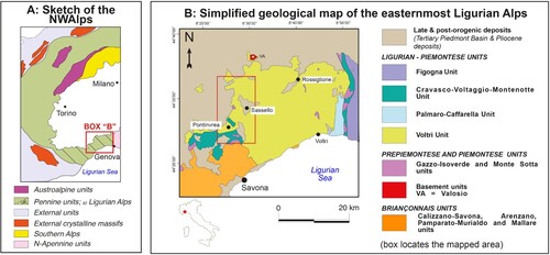
The mapped area, of about 190 km2, belongs to the Ligurian Alps, i.e. the southern termination of the Western Alps (Italy; ).
Figure 1. (a) Main geological units of the NW Alps; (b) simplified geological map of the central Ligurian Alps and location of the study area (red box).
Here the basement is composed of HP-LT tectono-metamorphic units that reached either eclogite or blueschist facies peak Alpine metamorphic conditions and were juxtaposed during exhumation. They consist of (i) metaophiolite of the Ligurian-Piemontese domain (the Montenotte, Palmaro-Caffarella and Voltri units), (ii) carbonatic sequences of continental margin affinity (the Piemontese Monte Sotta Unit) and (iii) slice of the paleo-European continental basement of internal Briançonnais affinity (the Bagnaschino Unit; CitationVanossi et al., 1984). These units are interpreted as relics of the Europe-Adria plate interface.
Their discordant sedimentary cover is represented by upper Eocene to Miocene continental to marine sediments of the Tertiary Piedmont Basin (TPB hereafter). The TPB is considered as a syn-tectonic Neoalpine-Apennine basin that evolved in a piggy-back position on the Monferrato thrust belt (CitationLorenz, 1969; CitationGelati & Gnaccolini, 1988, Citation1998; CitationMutti et al., 1995).
TPB was involved in the late-orogenic deformations, i.e. the top-to-the-E–NE back-thrusting and back-folding of the alpine tectonic units of the Ligurian Alps and associated strike-slip transfer faults, related to the Corsica-Sardinia block rotation (e.g. CitationPasquarè, 1968; CitationBernini & Zecca, 1990; CitationCapponi & Giammarino, 1982; CitationCapponi & Crispini, 2002; CitationSpagnolo et al., 2007; CitationMosca et al., 2009; CitationCrispini et al., 2009; CitationFederico et al., 2014).
We focus on the structures shared by the older sedimentary sequences of the TPB (Costa di Cravara breccia and Molare Formation) and the metamorphic units in the basement, which are well exposed in the mapped area.
The aim of this paper is to provide an original 1:25.000 geological map as a base to discuss:
− the relationships between the TPB sedimentary rocks and the metamorphic basement;
− the common tectonic structures;
− the local observations within the geodynamic evolution of the Alps-Apennine orogenic system.
2. Methods
The data were collected during fieldwork at 1:10,000 scale and stored in a GIS database that for the outcrops follows the logical structure depicted in . We used as topographic maps the ‘Carte Tecniche Regionali’ (C.T.R.) of Liguria and Piemonte Regions.
Table 1. Scheme of the database attached to the outcrop polygons in the GIS project, with type of the datum (second row) and an example (third row).
The data have been finally synthesized at 1:25,000 scale (see Main Map), using the topographic base of the Italian ‘Istituto Geografico Militare’ (I.G.M.).
Structural data were collected by means of a compass and analyzed using software for stereographic projections (OSXStereonet).
Fieldwork was integrated with photointerpretation of multi-temporal aerial images (1954 flight of Italian Military Geographical Institute at 1:55,000 scale and 1995 flight 13 of Liguria Region at 1:13,000 scale), as well as multi-temporal orthophotos available from the geoportal of Regione Liguria – https://srvcarto.regione.liguria.it/geoviewer2/pages/apps/geoportale/index.html.
3. Geological framework
The study area is characterized by: (i) a metamorphic basement composed of units of the Ligurian-Piemontese domain and, to a lesser extent, by Piemontese and Briançonnais units and (ii) an upper Eocene-lower Miocene sedimentary succession of the TPB ().
3.1. The metamorphic basement
The basement consists of a stack of five tectono-metamorphic units, from bottom to top:
the Bagnaschino Unit (CitationCortesogno et al., 1982; CitationVanossi et al., 1984), composed of a polymetamorphic pre-alpine crystalline complex of amphibolite-gneiss, pertaining to the paleo-European continent. It underwent synkinematic amphibolite facies metamorphism (S2 schistosity; CitationGaggero et al., 2004) during the Variscan orogeny, overprinted by an Alpine, mostly topotactic, blueschist facies recrystallisation (jadeite + quartz paragenesis and Na-amphibole rims on pre-Alpine hornblende; CitationMessiga, 1987; CitationCabella et al., 1991; CitationRossetti & Ferrero, 2008).
The Voltri tectono-metamorphic Unit (CitationCapponi et al., 2008a; CitationCapponi et al., 2016), composed of metamorphites derived from relics of oceanic crust (serpentinite, metagabbro and metabasalt) and cover (calcschist to micaschist and minor quartz-schist), and slices of subcontinental lithospheric mantle. It underwent eclogite facies metamorphism during subduction of the Ligurian-Piemontese ocean (a.o., CitationBocchio, 1995; CitationErnst, 1976; CitationMalatesta et al., 2012; CitationScarsi et al., 2018) and a later greenschist facies re-equilibration, in places predominant and pervasive.
This unit is characterized by superposed folding phases coeval with (Na-amphibole-bearing-) greenschist facies metamorphism (D1 and D2 of CitationCapponi & Crispini, 2002; CitationCapponi et al., 2008b); peak-eclogite facies foliations occur as relics without any regional continuity. Later large open folds, with rare low greenschist facies axial plane cleavages (D3 of CitationCapponi & Crispini, 2002) also occur in the Montenotte Unit (CitationFederico et al., 2015).
3. The Palmaro–Caffarella Unit (CitationChiesa et al., 1975), composed of metaophiolite (serpentinite, metagabbro and metabasalt) and metasediments (calcschist and qtz-schist) with peak alpine metamorphism in blueschist facies and moderate greenschist overprint (CitationCapponi et al., 2008b; Citation2016), In the study area it occurs only as fine-grained metabasalts.
This unit was coupled with the Voltri Unit in pre- to syn-greenschist facies conditions as it shares the same folding phases (D1 and D2 of CitationCapponi & Crispini, 2002).
4. The Monte Sotta Unit (CitationOxilia, 1978; CitationVanossi et al., 1984; CitationSeno et al., 2005; CitationDallagiovanna et al., 2011) consists of a carbonate platform sequence, represented, in the mapped area, by limited outcrops of metamorphic dolostone and limestone derived from upper Triassic/upper Jurassic sediments. They are recrystallised but contain rare cleavage or schistosity.
5. The Montenotte Unit (CitationVanossi et al., 1984; CitationFederico et al., 2015), composed of serpentinite, metagabbro, metabasalt and their cover of siliceous metasediment, metalimestone and phylladic schist. The metamorphic peak is in blueschist facies (CitationBeccaluva et al., 1979; CitationCabella et al., 1994; CitationDesmons et al., 1999). According to many authors (CitationRovereto, 1939; CitationHaccard & Lemoine, 1970; CitationCapponi et al., 2008b, Citation2013b), this unit is involved in the same syn-metamorphic structures as the Monte Sotta Unit that therefore shares a similar peak in blueschist-facies conditions (see paragraph 4).
The Montenotte Unit shows two syn-blueschist facies folding phases (CitationBeccaluva et al., 1979; CitationAnfossi et al., 1984; CitationCapponi et al., 2013b; CitationFederico et al., 2015). A later, syn-greenschist facies phase (D3) of open to gentle folding (CitationBeccaluva et al., 1979; CitationAnfossi et al., 1984; CitationCapponi et al., 2013b) is shared with the Voltri Unit (CitationFederico et al., 2015).
3.2. The Tertiary Piedmont Basin
The TPB is a sedimentary basin extended along the Piedmont-Liguria border (NW Italy) and is considered as a late- to post-orogenic basin that evolved in a piggy-back position on the Monferrato Complex thrust belt. Its depositional history is strongly controlled by tectonic and eustatic events (a.o.: CitationCapponi et al., 2001; CitationCapponi et al., 2009; CitationGelati & Gnaccolini, 1988; CitationGiglia et al., 1996; CitationMutti et al., 1995). This basin was filled with non-marine to marine sediments (upper Eocene-upper Miocene), which unconformably overlie the Ligurian Alps, Sestri-Voltaggio Zone, and NW termination of the Northern Apennine. The early stage of sedimentation of the TPB (upper Eocene-lower Miocene) are mainly represented by very coarse to very fine siliciclastic deposits and subordinately by reef limestones, that record pre-transgressive to transgressive conditions (a.o., CitationBonci et al., 2011; CitationCapponi et al., 2013a, Citation2013b; CitationFederico et al., 2016; CitationGelati et al., 2010; CitationGelati & Gnaccolini, 1988; CitationLorenz, 1969; CitationMutti et al., 1995; CitationQuaranta et al., 2009; and references therein).
In the study area, the basal section of the TPB (upper Eocene – lower Miocene?) is composed of fine to very coarse siliciclastic slope, alluvial fan, and river plain deposits that grade upwards to fan-delta sandstone and conglomerate (CRA and MOR, see the Main Map, upper Eocene – lower Oligocene). These sedimentary bodies are laterally discontinuous and overlain by littoral and sublittoral deposits and by reef limestones (MORt, Rupelian – middle Chattian). These lithofacies are overlain by fine to medium sandstone and siltstone (MORm, upper Oligocene). MORm facies records a deepening phase which culminates with the deposition of silty sandstones, siltstones, and marls, with locally interbedded sandstone and conglomerate lenses (RTM, upper Oligocene – lower Miocene?).
4. Lithostratigraphy
Formational names used in this paper have been defined in the adjacent CARG 213–230 ‘Genova’ Sheet (CitationCapponi et al., 2008a, Citation2008b) and the 212 ‘Spigno Monferrato’ Sheet of the Regional Geological Map of Regione Liguria (CitationCapponi et al., 2013a, Citation2013b), to which the interested reader is referred.
Full details on the lithostratigraphy are reported in the legend on the Main Map; in the following most relevant features are recalled.
4.1. The Bagnaschino unit
It is characterized by the Case Pradetti gneiss and the Poggio amphibolite, both cropping out at the southeastern limit of the map as the northern edge of a kilometric body. They underwent pre-alpine metamorphism and deformation, overprinted by a syn-blueschist alpine schistosity.
4.2. The Voltri unit
It is characterized by a metamorphosed ophiolitic sequence, encompassing:
− partially serpentinized peridotite (Monte Tobbio peridotite), mostly lherzolite, that occurs in a plurikilometric body in the northeastern part of the map and in other, smaller-scale lenses inside serpentinite;
− antigorite-rich serpentinite / serpentine schist (Bric del Dente serpentine schist), representing the predominant lithology of the unit;
− different types of eclogitic metagabbros, leucocratic (Colma metagabbro) and melanocratic (Passo del Faiallo eclogitic metagabbro and Case Buzzano eclogitic metagabbro), with variable degree of greenschist-facies overprint, occurring as lenses inside the serpentinite;
− greenschist facies metabasite (Rossiglione metabasite);
− greenschist facies metasediments (Turchino calcschist), including micaschist, quartz-micaschist and carbonate schist in large volumes in the southeastern and northern parts of the map.
4.3. The Palmaro – Caffarella unit
It consists only of two 100-m scale lenses of blueschist facies, fine-grained metabasite (Val Varenna metabasalt), outcropping in the north-eastern part of the map.
4.4. The Monte Sotta unit
It is made up of three main masses associated to metaophiolite of the Montenotte Unit and made up of meta-dolostone and meta-dolomitic limestone (Monte Rossotta dolostone) with impure, foliated meta-limestone (Monte Sotta limestone).
4.5. The Montenotte unit
It is characterized by a metamorphosed ophiolitic sequence, encompassing:
− massive serpentinite (Bric Autzè serpentinite) largely outcropping in the southern part of the map;
− different types of blueschist-facies metagabbro, either leucocratic (Bric Sportiole metagabbro) or melanocratic (Rocca Ghingherina metagabbro). They crop out in the southern and central part of the map in km- to pluri-km scale areas;
− blueschist facies foliated metabasalt (Bric del Tamburo metabasalt), occurring in 10-m -scale lenses in the southern and central part of the map;
− siliceous (Isola siliceous metasediment), calcareous (Poggio Castellaro limestone) and phylladic (Pian del Pino phylladic schist) metasediments pertaining to the original ophiolitic cover.
4.6. TThe Tertiary Piedmont Basin succession
4.6.1. Costa di Cravara breccia (CRA)
It consists of heterometric, very poorly to poorly sorted, mono/polygenic, matrix- to clast-supported, non-fossiliferous reddish breccia, that crops out as massive or roughly bedded chaotic bodies of moderate lateral extension and variable thickness (up to tens of meters).
Their feeding is strictly controlled by the lithological nature of the substrate, so the clasts can represent all the lithologies forming the pre-Oligocene substrate and it can be both monogenic and polygenic. Generally, the framework fraction is made up of very angular to angular clasts; the interstitial fraction is normally a sandy-pelitic matrix, but more or less abundant carbonate cement may be present.
The Costa di Cravara breccia is commonly referred to subaerial depositional environment, such as slope deposits, and doubtfully dated to the upper Eocene? – lower Oligocene? because of their stratigraphic position underlying the Molare Formation, whose age is relatively well defined.
4.6.2. Molare formation (MOR, MORt, MORm)
MOR: Heterometric (granule to boulder sized clasts), polymict, poorly sorted, clast- to matrix-supported conglomerate, with sandy matrix and minor carbonate cement, that crops out as few-meters thick, rough beds, locally interbedded with decimeter-thick fine- to coarse-grained, poorly sorted, polygenic sandstone with pelite matrix and minor carbonate cement beds and lenses. Fine to coarse, moderately to poorly sorted, polygenic sandstone with pelite matrix and minor carbonate cement organized in centimetric to metric beds. Subordinately massive, chaotic, heterometric breccia, siltstone, calcisiltite and claystone also occur. The fossil content includes coalified terrestrial plant remains, charales oogonites, fresh to brackish water molluscs, freshwater turtle and crocodile remains (for details, see CitationBonci et al., 2018; CitationBonci et al., 2011; CitationLorenz, 1969). These facies record alluvial fan, river plain, lacustrine, brackish lagoon and fan-delta depositional environments. Locally, in the upper part of MOR section, beach and very shallow sublittoral deposits made of siltstones, sandstones and conglomerates, in which branching coral small build-ups are rarely interbedded, also occur (for details, see CitationBonci et al., 2018; CitationBonci et al., 2011; CitationLorenz, 1969). This unit is regarded to be Oligocene in age.
MORt: Fine to coarse-grained, polymict, poorly sorted conglomerate, with sandy-to-silty matrix and subordinate carbonate cement, organized in lenticular, decimetric to metric beds, in which thin to medium litharenite layers are interbedded. This lithofacies normally grades upward to fine to coarse, poorly sorted litharenites with silty matrix and carbonate cement, organized in decimetric to pluridecimetric beds with erosive bedding plain and an internal architecture characterized by fine to thick, discontinuous, planar or wavy parallel lamination. These sediments locally alternate with fine to middle grained hybrid arenite with silty matrix and carbonate cement, arranged in thin layers with wavy, discontinuous bedding plains. The top of the MORt sequence is normally represented by very fine silty sandstone and clayey siltstone, organized in thick to medium layers, with thick and discontinuous planar parallel lamination. Coral boundstone are relatively frequent, which have grown directly on the metamorphic units or on MOR sediments, but also on the MORt basal lithofacies.
The paleontological content is very diverse, locally very abundant, and includes bryozoans, echinoids, gastropods, bivalves, corals, worm tubes, benthonic and planktonic foraminifers, calcareous red algae, and plant remains. Biolithites are, generally, the result of colonization stages with massive to encrusting and rarely branching growth forms. MORt deposited in tropical-subtropical marine delta to lagoon to shallow clastic platform environments but also reefal and rocky shore conditions are recorded (CitationFederico et al., 2016, and references therein; CitationGelati & Gnaccolini, 1988; CitationLorenz, 1969; CitationQuaranta et al., 2009 with reference therein).
A Rupelian – middle Chattian age is suggested by the paleontological content.
MORm: Coarse to fine, poorly sorted litharenites and hybrid arenites, with silty matrix and calcareous cement; these poorly bedded sediments may exhibit discontinuous planar parallel or cross-lamination and more or less intense bioturbation. They are followed upwards by coarse siltstones and marly siltstones with calcareous cement, organized in poorly distinguishable strata with discontinuous planar parallel lamination and, locally, intense bioturbation. Fine conglomerate lenses are interbedded in the top of the silty/marly lithofacies. The abundant fossil content includes echinoids, gastropods, bivalves, corals, bryozoans, worms, planktonic and benthic foraminifera, and red calcareous algae.
This unit deposited in a warm marine shallow clastic platform grading to hemipelagic environment during the upper Oligocene.
4.6.3. Rocchetta-Monesiglio formation (RTM)
Massive to well-bedded pelitic succession, characterized by the interbedding of centimetric to metric layers made of sandstones and of arenaceous and/or conglomeratic lenticular bodies, exhibit erosional base and highly variable thickness and lateral extension. The majority of the rocks of this formation consists of siltstones and marls and minor fine sandstones with carbonate cement, with, locally, intense bioturbation. The interbedded coarse-grained bodies are made of poorly sorted, polymict, massive or graded conglomerates and conglomeratic sandstones, and of coarse to fine sandstones. The fossil content is represented by echinoids, malacofaunas, benthic and planktonic foraminifers, and plant remains.
This thick section is interpreted as hemipelagic deposition and the interbedded arenaceous/conglomeratic bodies are the result of turbiditic, gravity-induced sedimentation of shallower environment sediments; it is dated to the upper Oligocene – lower Miocene.
5. Tectonic structures
The tectono-metamorphic units stacked together are characterized by varying P-T-t paths with different peak metamorphic conditions. We will briefly introduce the syn-metamorphic structures of the single units (following the same order shown in the legend of the Main Map) and then we will focus on the post-metamorphic structures involving both TPB sediments and basement. summarises the deformation–metamorphism relationships for each tectonic unit.
Table 2. Synoptic table showing the main deformation phases and related metamorphic or non-metamorphic conditions in the different units and TPB.
5.1. Syn-metamorphic tectonic foliations
5.1.1. Bagnaschino unit (BA)
The main syn-metamorphic schistosity can be interpreted as the S2 foliation described by CitationGaggero et al. (2004), produced by an amphibolite facies D2 deformation (here S2ba, with ‘ba’ subscript for the Bagnaschino Unit). In the study area, it is shallow-to-moderately dipping towards the N.
A second less pervasive schistosity is detectable in the gneiss and is associated with a blueschist-facies assemblage (S3ba); therefore, the Alpine metamorphic recrystallization, usually described as static (see, for instance, CitationMessiga, 1987; CitationRossetti & Ferrero, 2008), locally occurred dynamically.
5.1.2. Voltri unit
The most pervasive fabric is a Composite Fabric (CFvt, with the ‘vt’ subscript for the Voltri Unit) that controls the contacts between the formations of the Unit. It formed as a consequence of the superposition of at least two transpositive folding phases (CitationCapponi & Crispini, 2002), both coeval with greenschist-facies (or Na-amphibole-bearing greenschist-facies) metamorphism. In the study area, it is dominantly subhorizontal (see box in the Main Map) and represents the axial surface of F1vt/F2vt folds. Structures related to the high-pressure metamorphic stages occur as intrafoliar rootless hinges of isoclinal folds without any regional continuity.
Inside the Monte Tobbio peridotite, a mantle foliation is preserved (see Main map).
5.1.3. Palmaro-caffarella unit
In the study area, it only crops out as lenses of blueschist-facies metabasalt. It is characterized by an NW-SE striking, SE-dipping fabric that is a CFpa (the ‘pa’ subscript refers to the Palmaro-Caffarella Unit), due to the superposition of at least a two folding phases (D1pa + D2pa) coeval with (Na-amphibole bearing-) greenschist-facies metamorphism.
5.1.4. Monte Sotta unit
Within the meta-limestone and meta-dolostone of the Monte Sotta Unit cleavage or schistosity are rarely observed. On the contrary, bedding is often still recognizable.
Rocks of this unit occur at the top of the Bagnaschino Unit along with a N-dipping tectonic contact which is mostly parallel to the S2ba schistosity.
5.1.5. Montenotte unit
The Montenotte Unit is characterized by two syn-blueschist facies folding phases (D1mt and D2mt following CitationFederico et al. (2015); with the ‘mt’ subscript for the Montenotte Unit). The D2mt superposed on the D1mt folding give rise to Type 3 interference patterns (CitationRamsay & Huber, 1987), visible up to the map scale in the study area and to a composite fabric along which the contacts among different lithologies occur. Here it is mainly NW-SE striking, but with two maxima for NE- and SW-dipping planes (see rose diagrams in the Main Map) because of a successive folding phase (D3) with WNW-ESE trending, subhorizontal axis. D3 folds are open to gentle, sub-cylindrical, developed in low greenschist facies metamorphic conditions.
5.2. Post-metamorphic (late-orogenic) structures
The late stages of the orogenic evolution are characterized by: (i) long wave-length (up to several km) open folds and (ii) thrust faults, shallow dipping and mostly with a top-to-the E-NE sense of tectonic transport (D4 of CitationCapponi & Crispini, 2002 in ; CitationBernini & Zecca, 1990; CitationCapponi & Giammarino, 1982; CitationMosca et al., 2009; CitationPasquarè, 1968; CitationSpagnolo et al., 2007). These structures affect all the outcropping units and the TPB succession: therefore, we describe them for all the units overall. The age of D4 structures is bracketed between the age of the youngest deformed deposits of the TPB (upper Oligocene) and the age of the oldest undeformed sediments that seal the thrusts (Burdigalian, Citationd’Atri et al., 1997).
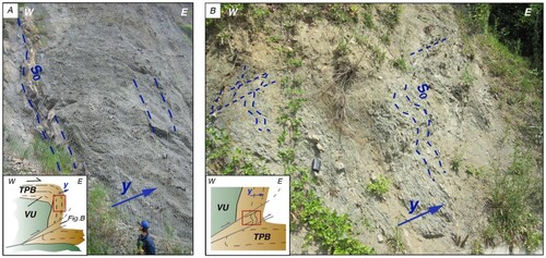
The folds are characterized by moderately to steeply W-SW-dipping axial surfaces; they show a top-to-the E-NE sense of shear resulting from the strong asymmetry ().
Figure 2. Field examples of tectonic structures within the TPB Molare Fm. (a) Tilted steeply dipping sandstone and conglomerate beds, close to the nonconformity surface with serpentinite (outcropping to the west and not shown in this photo). The vertical beds are part of top-to-the-east regional-scale thrust-related folds, simplified in the inset; the red box locates the outcrop within the main structure. La Pesca locality (north of Sassello village). (b) Tilted and folded fine-grained sandstone beds. The inset shows the regional-scale tectonic structure and the red box locates the field example within the structure. Badani locality (south of Sassello village). Dashed lines are the traces of bedding; blu arrows show the younging direction (y); TPB = Tertiary Piedmont Basin; VU = Voltri Unit; S0 = bedding.
Thrust faults are decorated by fault rocks (mainly crush breccias, with minor protocataclasite and cataclasite; sensu CitationSibson, 1977) that suggest fault activity at shallow structural levels. Many thrusts actually show oblique kinematics and are connected to a regional–scale E-W-striking strike-slip system (CitationFederico et al., 2014).
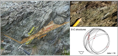
The D4 folds and thrusts locally rework the sin-metamorphic contacts among different units: an example crops out along the road from Pontinvrea to Ferriera (SW corner of the Main Map), where the Montenotte Unit is overthrusted on top of the Voltri Unit along a low-angle top-to E fault zone decorated by S–C structures (). This relationship between the two units is also shown in the A-A′ cross-section of the Main Map.
Figure 3. S-C structure along a low-angle top-to E fault zone at the contact between the Montenotte (hanging wall) and Voltri (foot wall) Units; road from Pontinvrea to Ferriera, Montenotte Inf. (SV), Italy.
A thorough investigation of such deformations is in CitationCapponi et al. (2001); in the following, we describe the most interesting examples of D4 structures in the study area (numbered from 1 to 3 in the Main Map).
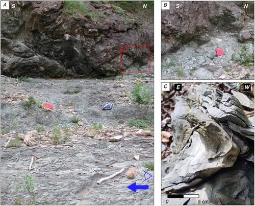
In the La Pesca – Roboaro locality (number 1 in the Main Map), the Molare Fm. is involved in tectonic structures with the serpentinite of the Voltri Unit. In the valley of the Roboaro River, a thrust surface between the Molare Fm. and serpentinite of the Voltri Unit is visible, and along the road the conglomerate at the contact with cataclastic serpentinite shows a subvertical bedding (see photo in the Main Map and (a) likely correlated with the same tectonic phase.
In the Monte Savino area (north of Sassello village; number 2 in the Main Map) bedding in the sandstone of the Molare Formation are steeply-dipping to the SW (). Gutter casts testify to overturned beds in the short limb of a strongly asymmetric fold.
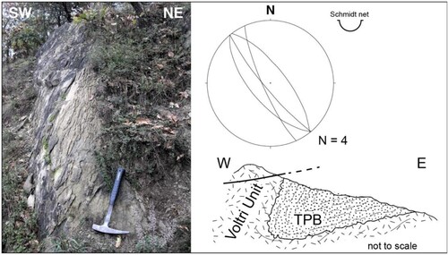
Figure 4. Steeply-dipping beds in sandstone of the Molare Formation (stereoplot shows S0 attitudes) that represent an overturned limb of a strongly asymmetric fold linked to D4 deformation. Schematic section redrawn after CitationCapponi et al. (2001); Monte Savino area (north of Sassello village).
The third example (number 3 in the Main Map) is an SW-dipping thrust surface that crops out southwest of Sassello, on the left hydrographic side of the Giovo River. Here the D4 backthrusting caused the tectonic superposition of the Voltri Unit onto the TPB (), as also shown in the B-B′ cross-section of the Main Map.
Figure 5. (a) Serpentinite of the Voltri Unit (in the hangingwall) that overthrusts sandstone/siltstone of the Molare Fm. (in the footwall). Red box locates picture B and blue arrow and eye the point of view of picture C. (b) Detail of the thrust surface and damage zone. (c) cm-scale fold in the sandstone/siltstone linked to the thrust movement; southwest of Sassello, left hydrographic side of the Giovo River.
6. Discussion
6.1. Syn-metamorphic nappe stacking
The metamorphic units observed in the mapped area were stacked within the orogenic wedge at different metamorphic conditions (): CFpa is concordant with the CFvt in the enclosing serpentinite of the Voltri Unit (see Main Map) and therefore, the coupling between the two units took place in the ductile realm, during syn-greenschist-facies deformations that occurred syn-exhumation. The coupling of the Montenotte Unit with the Monte Sotta Unit, considering the correlations cited in Par. 2.1, occurred probably already in blueschist facies conditions. The coupling of the Montenotte Unit with the Voltri Unit took place along a blueschist facies mylonite already described by CitationFederico et al. (2015) and is, therefore, pre-D3 ().
By the moment the D3 deformation phase occurred (i.e. low-greenschist facies conditions), all the units were stacked together within the exhuming orogenic wedge.
6.2. Post-metamorphic (late-orogenic) evolution: tectonics and sedimentation
The sedimentary succession on top of the metamorphic units provides unambiguous time constraints of orogen exhumation. The TPB developed on top of the orogenic wedge and was fed by metamorphic orogenic detritus: this demonstrates that metamorphic units were already exhumed and eroded at the onset of the Oligocene (a.o., CitationFederico et al., 2004; Citation2005; CitationGelati & Gnaccolini, 2003). This consideration also gives constraints for the exhumation rates: if we fix the time of surface exposure at 30 Ma, corresponding to the Early Oligocene age of deposition of the lower beds of the TPB conglomerates, eclogite rocks were exhumed from about 60 km depth in about 15–20 Ma (being eclogite peak estimated at 45–50 Ma; CitationFederico et al., 2005; CitationSmye et al., 2021); exhumation rates are therefore estimated in the 3–4 mm/a range (CitationFederico et al., 2005).
The D4 event is framed within a regional setting of NE-SW shortening (CitationSpagnolo et al., 2007; CitationCrispini et al., 2009). The Oligo-Miocene geodynamic scenario of the study area is dominated by the anticlockwise rotation of the Corsica-Sardinia block (e.g. CitationPasquarè, 1968; CitationCapponi & Giammarino, 1982; CitationCapponi et al., 2001; CitationGattacceca et al., 2007; CitationMaffione et al., 2008; CitationMosca et al., 2009), linked to the first stages of the Apennine orogeny. The contractional structures here described (reverse folds and thrusts) have been correlated by CitationFederico et al. (2014) to a left-hand strike-slip corridor that helps to achieve the rotation, together with other similar strike-slip faults of the Ligurian Alps – Northern Apennine system (Stura Fault, Villalvernia-Varzi Fault; CitationMarroni & Treves, 1998; CitationGiglia et al., 1996).
7. Conclusions
The coupling of the different metamorphic units of the basement occurred in different conditions during the exhumation path.
The metamorphic units were already exhumed and eroded at the onset of the Oligocene.
The D4 deformation phase is characterized by reverse folds and thrust faults, framed in a left-hand strike-slip context. These structures are linked to the anticlockwise rotation of the Corsica-Sardinia block and to the first stages of the Apennine orogeny.
Software
The software used for drawing this map is ®Adobe Illustrator CS4 and CS5, coupled with ®Avenza MaPublisher 8.3.3 that supplies the vector drawing software with GIS capabilities.
We first compiled a digital outcrop map with all the geological data where outcrops are displayed as solid colors areas: each vector feature is associated with a relational database containing both numerical, alphanumerical and boolean attributes (such as outcrop descriptions and photos, presence of rock samples, asbestos minerals, fossils, petrographic description of thin sections, etc.).
We subsequently use the outcrop map to draw a geological interpretative map where the outcrops are no longer shown.
The resulting geological map shows data that encompass four types of GIS features:
− a georeferenced raster image (Coordinate System Rome 1940 / Italy zone 1, Monte Mario/Italy 1);
− polygons;
− lines
− points.
Polygons are the areas of interpretative geology with solid colors corresponding to the various lithologies.
Lines are geological elements such as faults and thrusts, with different styles.
We show as points the different kinds of information, some as unoriented symbols (e.g. fossils), and other as oriented symbols, in particular, the attitude data: they express the orientation of planes (e.g. composite fabric, bedding, mantle foliation) and lines (e.g. fold axes) measured in the field. All attitude data are associated to a line of database composed of different fields (e.g. style of fold, measure of fold axial plane, reliability rank of attitude data, etc.).
The geodatabase is essential to draw the interpretative geological map; in fact, it allows to manage and analyse a large amount of data by means of complex tools of spatial analysis.
The rose diagrams of faults and the density plots of Composite Fabrics have been elaborated with the software OSXStereonet version 1.9.
TJOM_A_2012535_Supplementarymaterial
Download PDF (108.4 MB)Acknowledgements
The Authors thank Matteo Orecchia, Eugenio Poggi, Silvia Torchio, and Andrea Vigo for support in the field. The Authors acknowledge Marco Scambelluri for support and discussion about petrography of the metamorphic basement.
Disclosure statement
No potential conflict of interest was reported by the author(s).
Data availability statement
The data that support the findings of this study are available from Regione Liguria. Some are openly available at this site: https://geoportal.regione.liguria.it/ whereas for others some restrictions to the availability apply. They are available from the Authors with the permission of Regione Liguria.
Additional information
Funding
References
- Anfossi, R., Colella, S., & Messiga, B. (1984). Posizione strutturale e assetto litologico interno della falda di montenotte, nella zona compresa tra i torrenti letimbro e sansobbia. Memorie della Societa Geologica Italiana 28, 371–384.
- Beccaluva, L., Macciotta, G., Messiga, B., & Piccardo, G. B. (1979). Petrology of the blue-schists metamorphic ophiolites of the Montenotte nappe (Western liguria-Italy). Ofioliti, 4, 239–268.
- Bernini, M., & Zecca, M. (1990). Le deformazioni nella formazione di Molare e Rocchetta (Oligocene e Miocene inferiore) della regione di mioglia (SV) (margine sud del Bacino Terziario piemontese). Atti Ticinensi di Scienze Della Terra, 33, 1–10.
- Bocchio, R. (1995). Chemical variations in clinopyroxenes and garnet from eclogites of the vara valley (Voltri group), Italy. European Journal of Mineralogy, 7(1), 103–117. https://doi.org/10.1127/ejm/7/1/0103
- Bonci, M. C., Dabove, G. M., & Piazza, M. (2018). - The Oligocene mollusc types of gaetano Rovereto from Santa Giustina and Sassello (NW Italy). Carnets de Géologie, 18(12), 281–303. https://doi.org/10.4267/2042/68549
- Bonci, M. C., Vannucci, G., Tacchino, S., & Piazza, M. (2011). Oligocene fossil leaves of the perrando collection: History, preservation, and paleoclimatic meaning. Bollettino Della Società Paleontologica Italiana, 50(3), 145–164.
- Cabella, R., Cortesogno, L., Dallagiovanna, G., Gaggero, L., & Lucchetti, G. (1991). Metamorfismo alpino a giadeite + quarzo in crosta continentale nel Brianzonese ligure. Atti Ticinensi di Scienze della Terra, 34, 43–54.
- Cabella, R., Cortesogno, L., Gaggero, L., & Lucchetti, G. (1994). Clinopyroxenes through the blueschist facies metamorphism of the Liguria Alps: Compositional variability and miscibility gaps. Atti Ticinensi di Scienze della Terra, Ser. Spec., 1, 55–63.
- Capponi, G., & Crispini, L. (2002). Structural and metamorphic signature of alpine tectonics in the Voltri Massif (Ligurian Alps, northwestern Italy). Eclogae Geologicae Helvetiae, 95, 31–42.
- Capponi, G., & Crispini, L. (with collaboration of Bonci, M.C., Bruzzo, D., Cortesogno, L., Del Tredici, S., Firpo, M., Gaggero, L., Garofano, M., Giammarino, S., Lano, M., Pacciani, G., Piazza, M., Perilli, N., Piccazzo, M., Ramella, A., Vannucci, G., Vigo, E.). (2008a). Foglio 213 - 230 “Genova” della Carta Geologica d'Italia alla scala 1:50.000. APAT - Regione Liguria, Selca, Firenze.
- Capponi, G., Crispini, L., &con la collaborazione di Bonci, M. C., Cabella, R., Cavallo, C., Cortesogno, L., Fabbri, B., Federico, L., Firpo, M., Gaggero, L., Nosengo, S., Ottonello, G., Piazza, M., Perilli, N., Piccazzo, M., Ramella, A., Spagnolo, C., Vannucci, G., & Vetuschi Zuccolini, M. (2008b). Note Illustrative del Foglio 213 - 230 “Genova” della Carta Geologica d'Italia alla scala 1:50.000. Firenze: Apat - Regione Liguria.
- Capponi, G., Crispini, L., & Federico, L. (2013a). Note Illustrative al Foglio 212 “Spigno Monferrato” della Carta Geologica Regionale della Liguria. http://www.cartografia.regione.liguria.it/apriFoglia.asp?itemID=30208&fogliaID= 1579&label=Carta%20Geologica%20Regionale%20%28CGR%29%20sc.%201:25000%20riferita%20al%20Foglio%20212%20Spigno%20Monferrato%20-%20sc.%201:50000
- Capponi, G., Crispini, L., Federico, L., & con contributi di Cabella, R., Faccini, F., Ferraris, F., Firpo, M., Roccati, A., Marescotti, P., Piazza, M., Scambelluri, M. e collaborazione di Dabove, G. M., Poggi, E., Torchio, S, Vigo, A., & Vetuschi Zucolini, M. (2013b). Note Illustrative al Foglio 212 “Spigno Monferrato” della Carta Geologica Regionale della Liguria. Genova: Regione Liguria, http://www.cartografia.regione.liguria.it/apriFoglia.asp?itemID=30208&fogliaID=1575&label=Carta%20Geologica%20Regionale%20%28CGR%29%20sc.%201:10000%20riferita%20al%20Foglio%20212%20Spigno%20Monferrato%20-%20sc.%201:50000
- Capponi, G., Crispini, L., Federico, L., & Malatesta, C. (2016). Geology at the Ligurian Knot: A review of the tectonic units. Italian Journal of Geosciences, 135(1), 157–169. https://doi.org/10.3301/IJG.2015.06
- Capponi, G., Crispini, L., Federico, L., Piazza, M., & Fabbri, B. (2009). Late alpine tectonics in the Ligurian Alps: Constraints from the Tertiary Piedmont Basin conglomerates. Geological Journal, 44(2), 211–224. https://doi.org/10.1002/gj.1140
- Capponi, G., Crispini, L., Piazza, M., & Amandola, L. (2001). Field constraints to the Mid-Tertiary kinematics of the Ligurian Alps. Ofioliti, 26(2b), 409–416. https://doi.org/10.4454/ofioliti.v26i2b.162
- Capponi, G., & Giammarino, S. (1982). L'affioramento oligocenico del Rio siria (Bacino di Santa Giustina, provincia di savona), nel quadro dei movimenti tardivi della falda di montenotte. Atti Della Società Toscana di Scienze Naturali, A, 89, 101–113.
- Chiesa, S., Cortesogno, L., Forcella, F., Galli, M., Messiga, B., Pasquarè, G., & Rossi, P. M. (1975). Assetto strutturale ed interpretazione geodinamica del Gruppo di voltri. Bollettino Della Società Geologica Italiana, 94(3), 555–582.
- Cortesogno, L., Gianotti, R., Oxilia, M., Vannucci, R., & Vanossi, M. (1982). Genesi ed evoluzione dello zoccolo pre-mesozoico in alcuni settori del Brianzonese ligure interno. Rendiconti della Societa Italian di Mineralogia e Petrologia., 38, 219–260.
- Crispini, L., Federico, L., Capponi, G., & Spagnolo, C. (2009). Late orogenic transpressional tectonics in the Ligurian knot. Bollettino Della Societa Geologica Italiana, 128(2), 433–441. https://doi.org/10.3301/IJG.2009.128.2.433
- Dallagiovanna, G., Gaggero, L., Seno, S., Felletti, F., Mosca, P., Decarlis, A., Pellegrini, L., Poggi, F., Bottero, D., Mancin, N., Lupi, C., Bonini, L., Lualdi, A., Maino, M., & Toscani, G. (2011). Note illustrative della Carta Geologica d'Italia alla scala 1:50.000 - foglio 228 Cairo Montenotte. ISPRA - Regione Liguria, Litografia Artistica Cartografica s.r.l. p156.
- d’Atri, A., Piana, F., Tallone, S., Bodrato, G., & Roz Gastaldi, M. (1997). Tettonica oligo-miocenica nell'alto Monferrato (Bacino Terziario Piemontese) e nel settore nord-occidentale del Gruppo di Voltri (acqui terme e cassinelle, AL). Atti Ticinensi di Scienze Della Terra (Ser. Spec.), 5, 85–100.
- Desmons, J., Compagnoni, R., & Cortesogno, L. (1999). Alpine metamorphism of the Western Alps: II. High P/T and related pre-greenschist metamorphism. Schweizerische Mineralogische und Petrographische Mitteilungen, 79, 111–134. https://doi.org/10.5169/seals-60201
- Ernst, W. G. (1976). Mineral chemistry of eclogites and related rocks from the Voltri Group,Western Liguria, Italy. Schweizerische Mineralogische und Petrographische Mitteilungen, 56, 293–343.
- Federico, L., Capponi, G., Crispini, L., & Scambelluri, M. (2004). Exhumation of alpine high-pressure rocks: Insights from petrology of eclogite clasts in the Tertiary piedmontese basin (Ligurian Alps. Italy). Lithos, 74(1–2), 21–40. https://doi.org/10.1016/j.lithos.2003.12.001
- Federico, L., Capponi, G., Crispini, L., Scambelluri, M., & Villa, I. M. (2005). 39Ar/40Ar dating of high-pressure rocks from the Ligurian Alps: Evidence for a continuous subductionexhumation cycle. Earth and Planetary Science Letters, 240(3–4), 668–680. https://doi.org/10.1016/j.epsl.2005.09.062
- Federico, L., Crispini, L., Dabove, G. M., Piazza, M., & Capponi, G. (2016). Stratigraphic vs structural contacts in a late orogenic basin: The case of the Tertiary Piedmont Basin in the Sassello area (Ligurian Alps, Italy). Journal of Maps, 12(5), 959–967. https://doi.org/10.1080/17445647.2015.1100561
- Federico, L., Crispini, L., Malatesta, C., Torchio, S., & Capponi, G. (2015). Geology of the Pontinvrea area (Ligurian Alps, Italy): structural setting of the contact between Montenotte and Voltri units. Journal of Maps, 11(1), 101–113.
- Federico, L., Crispini, L., Vigo, A., & Capponi, G. (2014). Unravelling polyphase brittle tectonics through multi-software fault-slip analysis: The case of the Voltri Unit, Western Alps (Italy). Journal of Structural Geology, 68, 175–193. https://doi.org/10.1016/j.jsg.2014.09.011
- Gaggero, L., Cortesogno, L., & Bertrand, J. M. (2004). The pre-namurian basement of the Ligurian Alps: A review of the lithostratigraphy, pre-alpine metamorphic evolution, and regional comparisons. Periodico di Mineralogia, 73(2), 85–96.
- Gattacceca, J., Deino, A., Rizzo, R., Jones, D. S., Henry, B., Beaudoin, B., & Vadeboin, F. (2007). Miocene rotation of sardinia: New paleomagnetic and geochronological constraints and geodynamic implications. Earth and Planetary Sciences Letters, 258(3–4), 359–377. https://doi.org/10.1016/j.epsl.2007.02.003
- Gelati, R., & Gnaccolini, M. (1988). Sequenze deposizionali in un bacino episuturale, nella zona di raccordo tra Alpi ed Appennino settentrionale. Atti Ticinensi di Scienze Della Terra, 31, 340–350.
- Gelati, R., & Gnaccolini, M. (1998). Synsedimentary tectonics and sedimentation in the Tertiary Piedmont Basin, Northwestern Italy. Rivista Italiana di Paleontologia E Stratigrafia, 104(2), 193–214.
- Gelati, R., & Gnaccolini, M. (2003). Genesis and evolution of the langhe basin, with emphasis on the latest oligocene–earliest Miocene and serravallian. Atti Ticinensi di Scienze della Terra, 44, 3–18.
- Gelati, R., Gnaccolini, M., Polino, R., Mosca, P., Piana, F., Morelli, M., & Fioraso, G. (2010). con contributi di Balestro, G., Tallone, S., Ramasco, M., Fontan, D., Sorzana, P., Campus, S., & Ossella, L. Note Illustrative della Carta Geologica d'Italia alla scala 1:50.000, foglio 211 “Dego”. Progetto CARG, Ispra - Arpa Piemonte.
- Giglia, G., Capponi, G., Crispini, L., & Piazza, M. (1996). Dynamics and seismotectonics of the west-alpine arc. Tectonophysics, 267(1–4), 143–175. https://doi.org/10.1016/S0040-1951(96)00093-5
- Haccard, D., & Lemoine, M. (1970). Sur la stratigraphie et les analogies des formations sédimentaires associées aux ophiolites dans la zone piémontaise des Alpes ligures (zone de sestri - Voltaggio et de Montenotte) et des Alpes cottiennes (zone du gondran, queyras, haute ubaye). Compte rendu sommaire des séances de la Société géologique de France, 6, 209–210.
- Lorenz, C. (1969). Contribution à l'étude stratigraphique de l'Oligocène et du miocène inférieur des confins liguro-piémontais (italie). Atti Dell’Istituto di Geologia Dell’Università di Genova, 6, 253–888.
- Maffione, M., Speranza, F., Faccenna, C., Cascella, A., Vignaroli, G., & Sagnotti, L. (2008). A synchronous alpine and corsica–Sardinia rotation. Journal of Geophysical Research: Solid Earth, 113(B3),
- Malatesta, C., Crispini, L., Federico, L., Capponi, G., & Scambelluri, M. (2012). The exhumation of high pressure ophiolites (Voltri massif Western Alps): Insights from Structural and Petrologic Data on Metagabbro Bodies. Tectonophysics, 568–569, 102–123. https://doi.org/10.1016/j.tecto.2011.08.024
- Marroni, M., & Treves, B. (1998). Hidden terranes in the Northern Apennines, Italy: A record of late-cretaceous-Oligocene transpressional tectonics. Journal of Geology, 106(2), 149–162. https://doi.org/10.1086/516013
- Messiga, B. (1987). Alpine metamorphic evolution of Ligurian Alps (NW Italy): chemographic and petrological constraints inferred from metamorphic climax assemblage. Contributions to Mineralogy and Petrology, 95(3), 269–277. https://doi.org/10.1007/BF00371842
- Mosca, P., Polino, R., Rogledi, S., & Rossi, M. (2009). New data for the kinematic interpretation of the AlpseApennines junction (Northwestern Italy). International Journal of Earth Sciences, 99(4), 833–849. https://doi.org/10.1007/s00531-009-0428-2
- Mutti, E., Papani, L., Di Biase, D., Davoli, G., Mora, S., Segadelli, S., & Tinterri, R. (1995). Il Bacino Terziario epimesoalpino e le sue implicazioni sui rapporti tra Alpi ed appennino. Memorie di Scienze Geologiche, 47, 217–244.
- Oxilia, M. (1978). Stratigrafia e tettonica dell’unità di Monte Sotta (Alpi marittime). Atti Dell’Istituto Geologico Dell'Università di Pavia, 27, 15–24.
- Pasquarè, G. (1968). La serie di montenotte: Un elemento alloctono sovrapposto al bacino oligocenico di Santa Giustina (Alpi liguri). Rivista Italiana di Paleontologia e Stratigrafia, 74, 1257–1273.
- Quaranta, F., Piazza, M., & Vannucci, G. (2009). Climatic and tectonic control on the distribution of the Oligocene reefs of Tertiary Piedmont Basin (NW Italy). Italian Journal of Geosciences, 128(2), 587–591.
- Ramsay, J. G., & Huber, M. I. (1987). The techniques of modern structural geology. Volume 2: Folds and fractures (pp. 391). Academic Press.
- Rossetti, P., & Ferrero, S. (2008). The Zn-Pb deposits of casario (Ligurian Alps, NW Italy): late palaeozoic sedimentary-exhalative bodies affected by the alpine metamorphism. Geodinamica Acta, 21(3), 117–137. https://doi.org/10.3166/ga.21.117-137
- Rovereto, G. (1939). Liguria geologica. Memorie della Societa Geologica Italiana, 2, 743.
- Scarsi, M., Malatesta, C., & Fornasaro, S. (2018). Lawsonite-bearing eclogite from a tectonic mélange in the Ligurian Alps: New constraints for the subduction plate-interface evolution. Geological Magazine, 155(2), 280–297. https://doi.org/10.1017/S0016756817000395
- Seno, S., Dallagiovanna, G., & Vanossi, M. (2005). Pre-Piedmont and Piedmont-Ligurian nappes in the central sector of the Ligurian Alps: A possible pathway for their superposition on to the inner Briançonnais units. Bollettino-Societa Geologica Italiana, 124(2), 455–464.
- Sibson, R. H. (1977). Fault rocks and fault mechanisms. Journal of the Geological Society, 133(3), 191–213. https://doi.org/10.1144/gsjgs.133.3.0191
- Smye, A. J., Seman, S. M., Scambelluri, M., Starr, P. G., & Federico, L. (2021). Exhumation dynamics of high-pressure metamorphic rocks from the Voltri Unit, Western Alps: Constraints from phengite Rb–Sr geochronology. Contributions to Mineralogy and Petrology, 176(2), 176–114. https://doi.org/10.1007/s00410-020-01767-0
- Spagnolo, C., Crispini, L., & Capponi, G. (2007). Late structural evolution in an accretionary wedge: Insights from the Voltri Massif (Ligurian Alps, Italy). Geodinamica Acta, 20(1–2), 21–35. https://doi.org/10.3166/ga.20.21-35
- Vanossi, M., Cortesogno, L., Galbiati, B., Messiga, B., Piccardo, G., & Vannucci, R. (1984). Geologia delle Alpi liguri: Dati, problemi, ipotesi. Memorie della Societa Geologica Italiana, 28, 5–75.