
ABSTRACT
Mapping of coralligenous banks was carried out along the continental shelf of the northern and western margin of Sardinia Island (Italy, western Mediterranean Sea) in the context of the European Marine Strategy Framework Directive (MSFD, 2008/56/EC). Coralligenous banks are bioconstructions produced by calcareous coralline algae. Seafloor mapping was carried out through multibeam echosounder surveys and video transects, using a Remote Operating Vehicles (ROV), in areas not formerly explored. A high-resolution digital model of the seabed (DTM) was obtained from multibeam data. A total surface of 436 km2 of sparse patches of coralligenous banks was mapped in the depth range ~40-160 m. A final map of coralligenous habitat distributions along the western and northern continental shelf of Sardinia (scale 1:250,000) was produced. The base-map is formed by the shaded DTM of the seabed. Other mapped features include the edge of the continental shelf and the distribution of rocky seabed.
1. Introduction
The continental shelves of the Mediterranean Sea, from ∼20 m down to 120 m depth, can be characterized by the presence of the ‘coralligenous habitat’, a biogenic concretion that thrives exclusively in Mediterranean waters (CitationBallesteros, 2006; CitationÇinar et al., 2020; CitationPiazzi et al., 2021). Coralligenous habitat is considered as a hard substratum produced by the accumulation of calcareous coralline algae growing in low light conditions of 0.05% and 3% of the surface irradiance (CitationBallesteros, 1992; CitationBallesteros, 2006). Coralligenous growth is also influenced by nutrient concentration in the sea water (CitationPiazzi et al., 2011), sedimentation (CitationPiazzi et al., 2012) and temperature and salinity conditions (CitationBallesteros, 2006). Moreover, the coralligenous habitat is the result of interactions between the building activities of algal and animal constructors and biological and physical erosive processes (CitationMartin et al., 2014). The coralligenous communities, as well as other marine communities such as the meadow of Posidonia oceanica(L.)Delile (CitationDe Falco et al., 2017; CitationSimeone et al., 2018), can be considered a carbonate-producing ecosystem, because of the presence of calcifying organisms (CitationCanals & Ballesteros, 1997; CitationSartoretto et al., 1996).
Knowledge of the distribution of coralligenous habitats along the continental shelves of the Mediterranean Sea is crucial for the management and conservation of marine resources (CitationBracchi et al., 2017; CitationCogan et al., 2009; CitationÇinar et al., 2020; CitationPiazzi et al., 2021). Two main coralligenous types may be defined: coralligenous cliffs over littoral rocks, and coralligenous banks or platforms on continental shelves (CitationBallesteros, 2006; CitationMontefalcone et al., 2021).
CitationMartin et al. (Citation2014) reviewed the available data of coralligenous habitat distribution in the whole Mediterranean Sea, highlighting that the mapped polygons of coralligenous outcrops amounted to 2763.4 km2. They applied aprobabilistic model of coralligenous occurrence, estimating that as much as 95% of coralligenous habitat had still to be mapped (CitationMartin et al., 2014).
In recent years, the mapping effort of coralligenous habitat increased under the European Marine Strategy Framework Directive (MSFD; CitationEC, 2008). The MSFD aims to improve the environmental status of the seas and coralligenous assemblages are considered ‘special habitat types’ that should be monitored.
Direct observations of coralligenous banks are often prevented by water depth. To avoid these difficulties, geophysical acoustic data, coupled to ground truth data obtained with seabed sampling or video images of the seabed, have been more frequently used to map the seafloor (CitationBrambilla et al., 2019; CitationCosta & Battista, 2013; CitationDe Falco et al., 2010;CitationDi Martino et al., 2021; CitationInnangi et al., 2019a). Although new data of seabed mapping of the circalittoral zone have been locally produced (e.g. CitationBracchi et al., 2015; CitationBracchi et al., 2017; CitationCánovas Molina et al., 2016; CitationDe Luca et al., 2018; CitationGeorgiadis et al., 2009), the knowledge of coralligenous habitatsin the Mediterranean distribution is largely incomplete.
The aim of this work is to map the occurrence of coralligenous banks on the northern and western continental shelf of Sardinia in a depth range of ∼40-200 m. The investigated area is the largest shelf sector of the Mediterranean Sea where extended mapping of coralligenous banks has been performed. Seabed maps were obtained from a multibeam echosounder survey. Video images of the seafloor were collected to validate the interpretation of geophysical data.
2. Study area
Sardinia is the second island of the Mediterranean Sea with an area of ∼ 24,000 km2 and ∼ 2000km of coastline length (). The continental shelf of the western Sardinian margin is 5–40 km wide and is characterized by different morphological domains controlled by tectonic features (CitationCarboni et al., 1989; CitationConforti et al., 2016; CitationDe Falco et al., 2015a; CitationGeletti et al., 2014). A wide amphitheater facing the Gulf of Oristano occurs in the central-western sector with a smooth transition between the ∼25 km wide, continental shelf and the deep basin, at a depth of 2850 m. The amphitheater is bordered to the north and south by a continental shelf which is ∼40 km wide. In the northernwestern sector, the shelf is narrower (∼5-10 km)and connected to the deep basin by a steep slope (CitationSage et al., 2005). In the northern sector of the island, the continental shelf is 20-30 km wide and is deeply incised by the canyon of Castelsardo (main map) (CitationKenyon et al., 2002).
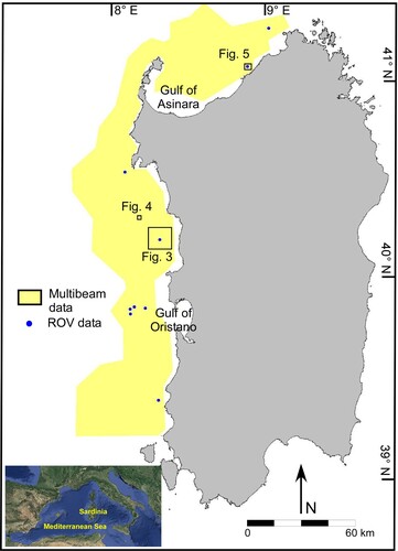
Figure 1. Map of Sardinia showing the acquisition area of multibeam echosounder data, the positions where video images were recorded by using a Remote Operating Vehicle (ROV). ROV transect length is 0.2-1.2 km. The positions of the seabed areas shown in , and are also shown.
The continental shelf is sediment starved (CitationCarboni et al., 1989; CitationDe Falco et al., 2011). The seabed is composed of an alternation of rocky outcrops, relict sedimentary deposits, and sands with a dominant carbonate compositions(∼60%) (CitationBrambilla et al., 2019; CitationCarboni et al., 1989; CitationConforti et al., 2016; CitationDe Falco et al., 2015b; CitationDe Luca et al., 2020; CitationLecca et al., 1983).
3. Methods
Multibeam echosounder (MBES) data were collected along the western and northern margin of the Sardinia Island (western Mediterranean Sea), from ∼40 m down to ∼500 m depth, covering a total area of 9930 km2(∼25,000 km of total line length) ( and ). MBES data were acquired during several oceanographic cruises on the R/V Maria Grazia, R/V Urania and R/V Minerva Uno of the National Research Council. The MBES used were: (i) Kongsberg EM 3002D (293-307 kHz, resolution 1 cm) for shallow areas, and (ii) Kongsberg EM 710 (200 kHz) and SeaBatReson 7111 (100 kHz) for deeper ones. Shallower data (ranging from 30 m of depth) were collected along a limited sector facing the SinisPeninsula () using the SeaBatReson 7125 (400 kHz). Multibeam data were processed using the software Caris Hips and Sips, and a Digital Terrain Model (DTM) at 2.5 m cell resolution was obtained for the whole investigated area. Backscatter data were also obtained by the multibeam data (CitationInnangi et al., 2019b).
Table 1. Summary of surfaces of the different sectors of the study area.
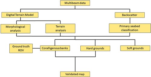
The processing sequence applied to geophysical data to obtain the final map is summarized in . The analysis of seabed morphology coupled to backscatter data was used for a primary classification of the seabed to discriminate soft vs. hard substrates. A detailed analysis of seabed morphological features coupled with terrain analysis of the DTM was performed to identify the areas potentially covered by coralligenous banks. The terrain parameters used for the analysis were slope and roughness and were extracted using the software Quantum-Gis (www.qgis.org). The slope is the angle of inclination to the horizontal for any cell. Roughness is the degree of irregularity of the surface. It is calculated by the largest inter-cell difference of a central pixel and its surrounding cell (https://docs.qgis.org/). The patches of coralligenous banks were then manually mapped using the software Global Mapper and exported as shapefile areas at 1.25,000 scale.
Figure 2. Flow chart showing the methodological steps used to obtain the final map.
Ground truth data were collected during two oceanographic cruises on the R/V Minerva Uno in 2013 and 2016. Video images of the seabed were recorded by using the Remote Operating Vehicle (ROV) Pollux 3, equipped with a high-resolution camera. The ROV was equipped with anacoustic positioning system for geo-localization of the video images. Seabed images were collected in 19 transects, distributed in six sectors () at 60-140 m depth. The transects were positioned over the coralligenous patches previously identified by the DTM analysis. The correspondence between seabed classification and ground truth data was tested using 88 snapshots randomly extracted from the video collected along the transects (4–5 images for each transect).
4. Results
4.1. Seabed mapping
The multibeam survey was processed at 2.5 m cell resolution producing a Digital Terrain Model of mid-outer continental shelf and upper continental slope of the western and northern Sardinia margin (main map). The shelf edge is located at 200-230 m depth in the western margin and at ∼150 m depth in the northern margin. The head of the canyon of Castelsardo incises the shelf up to ∼ 80 m depth. Eastward of the canyon head, the shelf edge is not defined by any break in slope (main map).
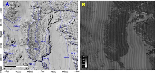
The analysis of the DTM showed that large sectors of the shelf are characterized by the presence of an irregular seabed surface ((a)). Backscatter data allowed us to distinguish three seabed types with different acoustic properties ((b)): (I) high backscatter seabed (black-dark grey), (ii) intermediate backscatter seabed (grey), and (iii) low backscatter seabed (light grey). High backscatter is associated with an irregular seabed surface ((a)) and mainly occurs at 40-160 m depth. Intermediate backscatter seabed is found on the outer shelf, and low backscatter values are found in the shallower sectors, between 60 and 100 m depth.
Figure 3. Digital terrain model (DTM, slope shader visualization) of a sector of western shelf showing the presence of an irregular seabed surface(left panel). The distribution of backscatter values (dB) of the same seabed sector is reported in the right panel. The irregular surface is associated to high backscatter intensity (location in ). The coordinates are expressed in meters (UTM-WGS 84-32N zone).
Analysis of the DTM highlights that distinct sectors of the seabed are characterized by the presence of groups of build-ups up to 4 m high. Those build-ups give a rough appearance to the seabed due high relief and steep flanks (). Lateral continuity can be assigned to two end-members according to CitationBracchi et al. (Citation2017): (i) tabular build-ups and (ii) isolated build-ups. Tabular build-up is the dominant morphology which forms a continuous cover on the seafloor ((a)) and extends up to 3 km in extent. Isolated build-ups are ten of meters in extent and are surrounded by a flat seabed ((a)).
Figure 4. (a) 3D view of the Digital Terrain Model (DTM) in a sector of the western Sardinia continental shelf (location in ), showing tabular and isolated builds-ups; (b) planar view of the DTM (B), slope (c) and roughness index (d) of the same sector. The coordinates are expressed in meters (UTM-WGS 84-32N zone).
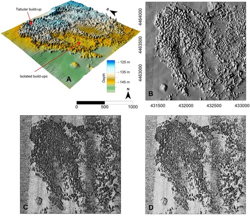
The terrain parameters slope and roughness are reported in (c and d). The area characterized by the presence of the build-ups is clearly enhanced after the application of selected terrain parameters to the DTM. Based on the DTM and terrain parameters, the build-ups were manually enclosed in polygons delimiting mappable patches at the chosen scale, 1:25,000 (). A total of 1406 polygons were traced, enclosing an area of 436 km2.
4.2. Ground truth data
The video images collected over the seafloor reveal that the build-ups correspond to living coralligenous banks (). Banks forming tabular build-ups are mainly built over more or less horizontal substrata and can have a very cavernous structure ().
Figure 5. 3D view of the DTM of the seafloor of a sector of northern continental shelf (location in ), reporting two tracks where video-images data were collected by using the ROV. Two snapshots were extracted from the videos, which depict the living coralligenous banks. The coordinates are expressed in meters (UTM-WGS 84-32N zone).
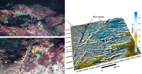
A good agreement between the seabed classification obtained from the DTM and terrain analysis and the occurrence of coralligenous banks in the ROV images was found. Each video transect confirms the presence of coralligenous living beds where the DTM and terrain analysis revealed the morphological features highlighted in . The analysis of 88 random images revealed the presence of coralligenous banks in 80 cases, thus confirming the good agreement between the seabed classification and the ground truth data. The remanent eight images revealed the presence of rhodolite beds or sediment deposits in flat areas among isolated build-ups.
5. Discussion
The irregular seabed surface characterized by high backscatter values can be attributed to the rocky substrate which outcrops along the continental shelf. The rocky substrate covers a total area of 2090 km2 mainly in the depth range of 40–160 m (main map), where it occupies 36% of the total surface encompassed within this bathymetric range (). In the outer shelf, the rocky substrate is progressively blanketed by the prograding sedimentary wedge (CitationCarboni et al., 1989), which is characterized by intermediate backscatter values ( and main map). In the inner shelf, the rocky outcrop encompasses are as characterized by a patchy distribution of coarse relict gravelly sands and medium-fine sands (CitationBracchi et al., 2017; CitationDe Falco et al., 2015b).
Figure 6. Bar chart of cumulative surface areas of seabed types, every 20 m of depth, along the western and northern continental shelf of Sardinia, in the depth range 40-160 m.
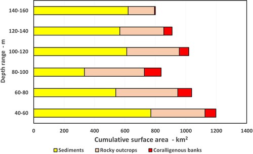
Coralligenous habitat extends over 436 km2 in the depth range 40–160 mand it colonizes8.8% of the surface of the continental shelf in this depth range (). The survey was extended to shallow depth, up to 20 m deep, in the central-western sector (main map). In this area the upper limit of the coralligenous patches occurs at about -30 m and a coexistence with Posidonia oceanica meadows is observable, similarly to the Apulia region, Southern Italy (CitationBracchi et al., 2017).
CitationMartin et al. (Citation2014) reviewed the available data of coralligenous mapping, highlighting that only 2763.4 km2 were mapped in the Mediterranean until 2014. The same authors reported that the major coralligenous occurrence are found in the depth range 10-50 m (CitationMartin et al., 2014). Successively, CitationBracchi et al. (2015, Citation2017) reported the distribution of coralligenous habitat on a wide shelf sector of Apulia region. Coralligenous extents along the Apulia shelf encompasseda total surface of 388 km2 in the depth range 10-100 m. In this study, the use of acoustic geophysical techniques (e.g. Multibeam echosounder), integrated with direct inspections of the seabed (CitationRomagnoli et al., 2021), allows for understanding of the extent of coralligenous habitats in the Mediterranean Sea, which is still underestimated (CitationBracchi et al., 2017; CitationMartin et al., 2014).
The depth distribution of the different types of seabed is shown in . Coralligenous banks were mapped down to 160 m depth with a maximum occurrence at 80-100 m depth. The deepest occurrence was located at about 160 m with an extensive presence of the habitat in the 120-140 m depth range in the north-western sector, offshore Alghero bay (main map). The depth of 160 m largely exceeds the maximum depth of coralligenous occurrence reported in the literature sofar, which is 120 m (CitationBallesteros, 2006). In Apulia, the extent of the coralligenous habitat does not exceed 100 m depth (CitationBracchi et al., 2017). The anomalously-deep occurrence of coralligenous habitats in western and northern Sardinia platform can be accounted for by two main factors: the first is related to the environmental conditions of the water column, and the second to the peculiar morphology of the continental shelf. It is well acknowledged that the maximum depth compatible with the presence of coralligenous concretions depends on the penetration of light (CitationBallesteros, 2006), therefore in areas with turbid waters the coralligenous habitat does not extend beyond the shallow water environment (CitationSartoretto et al., 1996). Conversely, coralligenous habitats have been reported down to 120 m depths in areas with very clear waters, which are generally located far from the sedimentary input points (CitationBallesteros & Zabala, 1993; CitationLaborel, 1987). This is the case in western and northern Sardinia, where the coastal areas lack alluvial plains and fluvial sediment yields and the continental shelf shows the typical features of a sediment starved environment. Moreover, the extensive rocky seabed down to 170-180 m, the occurrence of wide seagrass meadows in the infralittoral zone, the prevalence on the loose seabed of coarse sediments with a mainly carbonate composition (CitationBrambilla et al., 2019; CitationDe Falco et al., 2011; CitationDe Falco et al., 2015a) favor the occurrence of clear waters and as a consequence, the development at depth of the coralligenous habitat (CitationBallesteros, 2006; CitationMartorelli et al., 2014; CitationPérès & Picard, 1964). In western Sardinia the continental shelf extends with a very low gradient down to a depth of about 200 m, whereas most of the continental shelves in the Mediterranean have the edge located at a depth of 50-160 m(CitationAcosta et al., 2002; CitationLobo et al., 2014; CitationMartorelli et al., 2014). Moreover, a large part of the seabed in western Sardinia is characterized by a outcrops of the rocky basement (), which is an ideal substratum for coralligenous colonization (CitationGot & Laubier, 1968; CitationLaborel, 1987). These conditions favor the presence of extended coralligenous habitats (CitationBallesteros, 2006; CitationMartorelli et al., 2014; CitationPérès & Picard, 1964).
There is not a general agreement on the substrate where coralligenous banks can develop. Coralligenous banks are sometimes surrounded by sedimentary substrata and CitationPérès and Picard (Citation1952) argued that they developed from the coalescence of rhodolites or maërl, forming the so called ‘coralligène de plateau’. The same observation was reported by CitationBracchi et al. (Citation2017), who supported the hypothesis of banks growing from a sedimentary substrate. Other authors maintain that coralligenous banks are grown upon rocky outcrops (CitationGot & Laubier, 1968; CitationLaborel, 1987). In our case coralligenous banks are clearly associated with rocky outcrops and thus their occurrence is related to the morpho-tectonic features of the continental shelf. In this study the coralligenous banks occupy 21% of the rocky substrate. This percentage could be underestimated compared to the real coverage as it is based on the detection of the banks that show a morphological expression which is identifiable at the resolution used in this survey.
6. Conclusion
The map of coralligenous banks of the western and northern continental shelf of Sardinia was produced at a 1:250,000 scale. The map contains the digital terrain model of the seabed in the depth range 40-500 m, the position of the continental shelf edge, the polygons enclosing the rocky substate on shelf, and the polygons enclosing the coralligenous banks.
The map provides new insights on the coralligenous habitat distribution in the Mediterranean Sea, revealing its huge extent over the shelf, thus contributing to the knowledge of the habitat distribution requested by the European Marine Strategy framework directive.
The map provides new information on habitat characteristics. Specifically, (i) the maximum depth where the banks were detected was 160 m, that is among the greatestdepth recorded for this habitat, and (ii) the coralligenous banks are associated with rocky outcrops which, in turn, are related to the morpho-tectonic features of the continental shelf.
Software
The following software were used for multibeam data processing, digital terrain model analysis and final map production: Caris Hips and Sips, Global Mapper 21, Golden Software Inc. Surfer 17, ArcGis 10, Quantum-GIS, Microsoft Office 365 – Publisher, Inkscape(1989, 1991 Free Software Foundation, Inc). All software were licensed to National Research Council.
Funding details
The work was partially funded by the following projects: ‘Magic’ (MArineGeohazard along the Italian Coasts), funded by Italian Civil Protection Department and ‘Marine Strategy’ funded by Agenzia Regionale per la Protezione Ambientale della Sardegna (ARPAS). Additional funds are Base Research Project, L. R. 7 agosto 2007, Project: “Cambiamenti climatici e neotettonica – la Sardegna un continente semi-stabile”, funded by Regione Autonoma della Sardegna, (RAS, Assessorato della Programmazione, Bilancio, Credito e Assetto del Territorio - Code RASSR14473 - Bando 2017, Resp. Vincenzo Pascucci).
Data redepository
Data are available at http://marinedata.cnr.it/index.php/geo-habitat/
Geo-localisation information
The map provided area is located at following coordinates: - below left corner:4342289 N; 412371 E - above right corner: 4575749 N; 514883 E (UTM WGS84 zone 32N)
TJOM_2020179_Supplemenatrymaterial
Download PDF (14.6 MB)TJOM_2020179_Supplemenatrymaterial
Download PDF (32 MB)Acknowledgments
Geophysical data and ROV images were collected during several oceanographic cruises using the R/V Maria Grazia R/VUrania and R/V Minerva UNO of the Consiglio Nazionale delleRicerche. We acknowledge the crews of the vessels.
Disclosure statement
No potential conflict of interest was reported by the author(s).
Data availability statement
All the data used to realize the map of coralligenousare property of Consiglio Nazionale delleRicerche.
Related Research Data
References
- Acosta, J., Canals, M., López-Martínez, J., Muñoz, A., Herranz, P., Urgeles, R., Palomo, C., & Casamor, J. L. (2002). The balearic promontory geomorphology (western Mediterranean): morpho-structure and active processes. Geomorphology, 49(3-4), 177–204. https://doi.org/10.1016/S0169-555X(02)00168-X
- Ballesteros, E. (1992). Els vegetalsi la zonaciólitoral: Espècies, comunitatsi factors que influeixenen la sevadistribució. ArxiusSeccióCiències, 101, 1–616. Barcelona: Institutd’Estudis Catalans. ISBN: 84-7283-210-4.
- Ballesteros, E. (2006). Mediterranean coralligenous assemblages: A synthesis of present knowledge. Oceanography and Marine Biology: An Annual Review, 44, 123–195. https://doi.org/10.1201/9781420006391-7
- Ballesteros, E., & Zabala, M. (1993). El bentos: El marc físic. In Història Natural de l’Arxipèlag de cabrera. In J. A. Alcover, E. Ballesteros, & J. J. Fornos (Eds.), Monografies de la Societatd’Història Natural de balears 2 (pp. 663–685). CSIC-Ed. Moll.
- Bracchi, V. A., Basso, D., Marchese, F., Corselli, C., & Savini, A. (2017). Coralligenous morphotypes on subhorizontal substrata: A new categorization. Continental Shelf Research, 144, 10–20. https://doi.org/10.1016/j.csr.2017.06.005
- Bracchi, V. A., Savini, A., Basso, D., Marchese, F., & Corselli, C. (2015). Coralligenous habitat in the Mediterranean Sea: A geomorphological description from remote data. Italian Journal of Geoscience, 134(1), 32–40. https://doi.org/10.3301/IJG.2014.16
- Brambilla, W., Conforti, A., Simeone, S., Carrara, P., Lanucara, S., & De Falco, G. (2019). Data set of submerged sand deposits organised in an interoperable spatial data infrastructure (Western Sardinia, Mediterranean Sea). Earth System Science Data, 11(2), 515–527. https://doi.org/10.5194/essd-11-515-2019
- Canals, M., & Ballesteros, E. (1997). Production of carbonate particles by phytobenthic communities on the Mallorca-Menorca shelf, northwestern Mediterranean Sea. Deep-Sea Research, 44, 611–629. https://doi.org/10.1016/S0967-0645(96)00095-1.
- Cánovas Molina, A., Montefalcone, M., Vassallo, P., Morri, C., Bianchi, C. N., & Bavestrello, G. (2016). Combining literature review, acoustic mapping and in situ observations: An overview of coralligenous assemblages in Liguria (NW Mediterranean Sea). Scientia Marina, 80, 7–16. https://doi.org/10.3989/scimar.04235.23A
- Carboni, S., Lecca, L., & Ferrara, C. (1989). La discordanza versiliana sulla piattaforma occidentale della Sardegna. Bollettino Società Geologica Italiana, 108, 503–519.
- Çinar, M. E., Féral, J. P., Arvanitidis, C., David, R., & Taşkin, E. (2020). Coralligenous assemblages along their geographical distribution: Testing of concepts and implications for management. Aquatic Conservation: Marine and Freshwater Ecosystems, Wiley, 30(8), 1578–1594. https://doi.org/10.1002/aqc.3365.hal-02892573
- Cogan, C. B., Todd, B. J., Lawton, P., & Noji, T. T. (2009). The role of marine habitat mapping in ecosystem-based management. ICES Journal of Marine Science, 66(9), 2033–2042. https://doi.org/10.1093/icesjms/fsp214
- Conforti, A., Budillon, F., Tonielli, R., & De Falco, G. (2016). A newly discovered Pliocene volcanic field on the western Sardinia continental margin (western Mediterranean). Geo-Marine Letters, 36(1), 1–14. https://doi.org/10.1007/s00367-015-0428-0
- Costa, B. M., & Battista, T. A. (2013). The semi-automated classification of acoustic imagery for characterizing coral reef ecosystems. International Journal of Remote Sensing, 34(18), 6389–6422. https://doi.org/10.1080/01431161.2013.800661
- De Falco, G., Antonioli, F., Fontolan, G., Lo Presti, V., Simeone, S., & Tonielli, R. (2015a). Early cementation and accommodation space dictate the evolution of an overstepping barrier system during the Holocene. Marine Geology, 369, 52–66. https://doi.org/10.1016/j.margeo.2015.08.002
- De Falco, G., Budillon, F., Conforti, A., Di Bitetto, M., Di Martino, G., Innangi, S., Simeone, S., & Tonielli, R. (2015b). Sorted bedforms over transgressive deposits along the continental shelf of western Sardinia (Mediterranean Sea). Marine Geology, 359, 75–88. https://doi.org/10.1016/j.margeo.2014.11.008
- De Falco, G., De Muro, S., Batzella, T., & Cucco, A. (2011). Carbonate sedimentation and hydrodynamic pattern on a modern temperate shelf: The strait of Bonifacio (western Mediterranean). Estuarine, Coastal and Shelf Science, 93(1), 14–26. https://doi.org/10.1016/j.ecss.2011.03.013
- De Falco, G., Molinaroli, E., Conforti, A., Simeone, S., & Tonielli, R. (2017). Biogenic sediments from coastal ecosystems to beach-dune systems: Implications for the adaptation of mixed and carbonate beaches to future sea level rise. Biogeosciences (online), 14(13), 3191–3205. https://doi.org/10.5194/bg-14-3191-2017
- De Falco, G., Tonielli, R., Di Martino, G., Innangi, S., Simeone, S., & Parnum, I. M. (2010). Relationships between multibeam backscatter, sediment grain size, and Posidonia oceanica seagrass distribution. Continental Shelf Research, 30(18), 1941–1950. https://doi.org/10.1016/j.csr.2010.09.006
- De Luca, M., Chaiallah, A., Andreucci, S., Cossu, G., Santonastaso, A., Sechi, D., Stelletti, M., & Pascucci, V. (2020). Seafloor Map of the Alghero Bay (Sardinia, Italy). Journal of Maps, 16(2), 669–679. https://doi.org/10.1080/17445647.2020.1805808
- De Luca, M., Pascucci, V., Gazale, V., Ruiu, A., Massetti, L., & Cossu, A. (2018). Marine benthic forms of the Marine Protected Area Capo Caccia-Isola Piana (Sardinia, Italy). Journal of Maps, 14(2), 421–427. https://doi.org/10.1080/17445647.2018.148624
- Di Martino, G., Innangi, S., Sacchi, M., & Tonielli, R. (2021). Seafloor morphology changes in the inner-shelf area of the Pozzuoli Bay, Eastern Tyrrhenian Sea. Marine Geophysical Research, 42(2), 1–15. https://doi.org/10.1007/s11001-021-09434-0
- EC. (2008). MSFD 2008/56/EC of the European Parliament and of the Council, of 17 June 2008, establishing a framework for community action in the field of marine environmental policy (Marine Strategy Framework directive). Official Journal of the European Commission, G.U.C.E. 25/6/2008, L 164/19.
- Geletti, R., Zgur, F., DelBen, A., Buriola, F., Fais, S., Fedi, M., Forte, E., Mocnik, A., Paoletti, V., Pipan, M., Ramella, R., Romeo, R., & Romi, A. (2014). The MessinianSalinityCrisis: New seismicevidence in the West-SardinianMargin and EasternSardo-Provençal basin (West MediterraneanSea). Marine Geology, 351, 76–90. https://doi.org/10.1016/j.margeo.2014.03.019
- Georgiadis, M., Papatheodorou, G., Tzanatos, E., Geraga, M., Ramfos, A., Koutsikopoulos, C., & Ferentinos, G. (2009). Coralligène formations in the eastern Mediterranean Sea: Morphology, distribution,mapping and relation to fisheries in the southern Aegean Sea (Greece) based onhigh-resolution acoustics. Journal of Experimental Marine Biology and Ecology, 368(2009), 44–58. https://doi.org/10.1016/j.jembe.2008.10.001
- Got, H., & Laubier, L. (1968). Prospection sysmique au large des Albères: Nature du substratoriginel ducoralligène. Vie et Milieu, 19, 9–16.
- Innangi, S., Di Martino, G., Romagnoli, C., & Tonielli, R. (2019a). Seabed classification around Lampione islet, Pelagie Islands Marine Protected area, Sicily Channel, Mediterranean Sea. Journal of Maps, 15(2), 153–164. https://doi.org/10.1080/17445647.2019.1567401
- Innangi, S., Tonielli, R., Romagnoli, C., Budillon, F., Di Martino, G., Innangi, M., Laterza, R., Le Bas, T., & Lo Iacono, C. (2019b). Seabed mapping in the Pelagie Islands marine protected area (Sicily Channel, Southern Mediterranean) using Remote Sensing object based image analysis (RSOBIA). Marine Geophysical Research, 40(3), 333–355. https://doi.org/10.1007/s11001-018-9371-6
- Kenyon, N. K., Klaucke, I., Millington, J., & Ivanov, M. K. (2002). Sandy submarine canyon-mouth lobes on the western margin of Corsica and Sardinia, Mediterranean Sea. Marine Geology, 184(1-2), 69–84. https://doi.org/10.1016/S0025-3227(01)00282-1
- Laborel, J. (1987). Marine biogenetic constructions in the Mediterranean, a review. Scientific Reports of the Port-Cros NationalPark, 13, 97–126.
- Lecca, L., Scarteddu, R., & Sechi, F. (1983). La piattaforma continentale sarda da Capo Mannu a Capo Marrargiu. Bollettino Società Geologica Italiana, 102, 57–86.
- Lobo, F. J., Ercilla, G., Fernández-Salas, L. M., & Gámez, D. (2014). The Iberian Mediterranean shelves. In F. L. Chiocci, & A. R. Chivas (Eds.), Continental shelves of the world: Their evolution during the last glacio-eustatic cycle (pp. 147–170). Geological Society. https://doi.org/10.1144/M41.11
- Martin, C. S., Giannoulaki, M., De Leo, F., Scardi, M., Salomidi, M., Knitweiss, L., Pace, M. L., Garofalo, G., Gristina, M., Ballesteros, E., Bavestrello, G., Belluscio, A., Cebrian, E., Gerakaris, V., Pergent, G., Pergent-Martini, C., Schembri, P. J., Terribile, K., Rizzo, L., … Fraschetti, S. (2014). Coralligenous and maërl habitats: Predictive modelling to identify their spatial distributions across the Mediterranean Sea. Scientific Reports, 4(1), 1–9. https://doi.org/10.1038/srep05073
- Martorelli, E., Falese, F., & Chiocci, F. L. (2014). Overview of the variability of late quaternary continental shelf deposits of the Italian peninsula. In F. L. Chiocci, & A. R. Chivas (Eds.), Continental shelves of the world: Their evolution during the last glacio-eustatic cycle (pp. 171–186). Geological Society. http://doi.org/10.1144/M41.12
- Montefalcone, M., Tunesi, L., & Ouerghi, A. (2021). A review of the classification systems for marine benthic habitats and the new updated Barcelona convention classification for the Mediterranean. Marine EnvironmentalResearch, 169, 105387. https://doi.org/10.1016/j.marenvres.2021.105387
- Pérès, J., & Picard, J. M. (1952). Les corniches calcaires d’origine biologique en Méditerranée occidentale. Recueil des Travaux de la Station Marine D’Endoume, 4, 2–33.
- Pérès, J., & Picard, J. M. (1964). Nouveau manuel de bionomie benthique de la mer Méditerranée. RecueildesTravaux de la Station Marine D’Endoume, 31(47), 1–131.
- Piazzi, L., Gennaro, P., & Balata, D. (2011). Effects of nutrientenrichment on macroalgal coralligenous assemblages. Marine PollutionBulletin, 62(8), 1830–1835. https://doi.org/10.1016/j.marpolbul.2011.05.004
- Piazzi, L., Gennaro, P., & Balata, D. (2012). Threats to macroalgal coralligenous assemblages in the Mediterranean Sea. MarinePollutionBulletin, 64(12), 2623–2629. Doi 10.1016/j.marpolbul.2012.07.027
- Piazzi, L., Gennaro, P., Cecchi, E., Bianchi, C. N., Cintia, M. F., Gatti, G., Guala, I., Morri, C., Sartoretto, F., Serena, F., & Montefalcone, M. (2021). Ecological status of coralligenous assemblages: Ten years of application of the ESCA index from local to wide scale validation. Ecological Indicators, 121, 107077. https://doi.org/10.1016/j.ecolind.2020.107077
- Romagnoli, B., Grasselli, F., Costantini, F., Abbiati, M., Romagnoli, C., Innangi, S., Di Martino, G., & Tonielli, R. (2021). Evaluating the distribution of priority benthic habitats through a remotely operated vehicle to support conservation measures off Linosa Island (Sicily Channel, Mediterranean Sea). Aquatic Conservation: Marine and Freshwater Ecosystems, 31(7), 1686–1699. https://doi.org/10.1002/aqc.3554
- Sage, F., Von Gronefeld, G., Déverchère, J., Gaullier, V., Maillard, A., & Gorini, C. (2005). Seismic evidence for Messinian detrital deposits at the western Sardinia margin, northwestern Mediterranean. Marine and Petroleum Geology, 22(6-7), 757–773. https://doi.org/10.1016/j.marpetgeo.2005.03.007
- Sartoretto, S., Verlaque, M., & Laborel, J. (1996). Age of settlement and accumulation rate of submarine “coralligène” (–10 to –60 m) of the northwestern Mediterranean Sea; relation to Holocene rise in sea level. Marine Geology, 130(3-4), 317–331. https://doi.org/10.1016/0025-3227(95)00175-1
- Simeone, S., Molinaroli, E., Conforti, A., & De Falco, G. (2018). Impact of ocean acidification on the carbonate sediment budget of a temperate mixed beach. Climatic Change, 150(3-4), 227–242. https://doi.org/10.1007/s10584-018-2282-3