
ABSTRACT
The Fiumarella di Corleto drainage basin is an emblematic sector of the southern Apennine thrust belt in the Basilicata region (Southern Italy), which is strongly affected by landslides. Landslides both affect the urban area and the facilities related to hydrocarbon exploitation, such as the pipelines and oil wells connected with the oil centre located just outside the eastern border of the study area. Based on a detailed field survey, supported by stereoscopic analysis, a landslide inventory map has been realized, which also reports the associated processes and landforms. The relationships between the different types of landslides and the various predisposing factors like outcropping lithologies, slopes steepness, slope exposition and land use have been also investigated. The acquired data relate to a geologically complex area of the southern Apennines subject to recent uplift and represent a fundamental contribution useful for the correct management of the territory.
1. Introduction
The southern Apennine sector of the Basilicata region is subject to high hydrogeological risk. Landslides are considered among the most important factors of regional risk and their occurrence is linked to the geological complexity and both the geomorphological and climatic history. Landslides are also linked to natural factors, as lithostratigraphic setting of the slopes, eustatic and climatic variations, neotectonic uplift, seismic events and surface erosion processes, frequently influenced by anthropic activities. Moreover, destabilizing factors may result from uncontrolled and often unconscious human activities.
Here we focus on the factors that determine the landslide hazard in the ‘Fiumarella di Corleto’ stream (FdC) drainage basin. The aim is to identify several geomorphological indexes preparatory to the study of landslide susceptibility in GIS environment (CitationCarrara et al., 1995; CitationLazzari & Gioia, 2016; CitationLazzari & Piccarreta, 2018; CitationPack et al., 2005; CitationTerhorst & Kreja, 2009). A landslide inventory map (LIM), consisting of several information layers (CitationLazzari et al., 2018; CitationGuzzetti et al., 2012), was also created. It shows the location, extent, type of landslides and their activity status.
We also correlate the different types of landslides and their state of activity with the main predisposing factors like outcropping lithologies, slope steepness, slope exposure and land use management.
The acquisition of geomorphological data is useful for land management, hazard assessment and the collection of information on the susceptibility of landslides in a sector of the southern Apennine chain subject to rapid uplift.
2. Methods
The entire area of the FdC drainage basin, extending for approximately 50 km2, was interested in a geological field survey which has allowed to highlight both the stratigraphic and structural aspects. The results are shown in the geological map of the main map on a scale 1:10,000 ortho-maps of the Basilicata Region (https://rsdi.regione.basilicata.it), following the approach adopted by CitationBentivenga et al. (2012, Citation2014, Citation2016, Citation2019, Citation2021).
The geomorphological aspects were analysed by means of a stereoscopic study carried out using the IGM (Istituto Geografico Militare) aerial photos relating to the 2003 flight at a 1: 33,000 scale and the more recent high-resolution Google Earth images. Subsequently, the different morphologies were validated in the field. The LIM of the FdC drainage basin was created taking into account previous works, such as the results of the National Projects ‘Inventario dei Fenomeni Franosi in Italia’ (IFFI), Piano stralcio per la difesa dal rischio idrogeologico (PAI), Aree Vulnerate Italiane (AVI) and Studio dei Centri Abitati Instabili (SCAI) (CitationGuzzetti et al., 1994, Citation2000; CitationTrigila et al., 2010) and also includes the classification of all the detected morphologies such as trenches, detachment scarps, etc.
Landslides were classified according to CitationVarnes (1978) and checked for their state of activity, detecting any damage to potentially involved anthropic structures (CitationCruden & Varnes, 1996). The state of activity of each individual landslide has been mainly defined from observations carried out on all the infrastructures and in particular on the linear infrastructures. Observations include the presence of buildings affected by fractures generated by the activity of large landslides and damaged roads crossed by landslide bodies. In the latter case, roads that serve several farms in the area require continuous maintenance works to ensure their practicability.
Moreover, a statistical analysis was performed in a GIS environment to quantify the distribution of mass movements and to outline the relationships of landslide distribution with lithology, topography (slope and aspect) and land use. The analysis of predisposing factors was obtained by carrying out a statistical analysis on the detected landslides. This takes into account the distribution of landslide areas and their frequency (CitationGuzzetti et al., 2002).
Furthermore, all the relationships existing between landslides and geological and geomorphological features have been highlighted.
To this end, a lithological map (see the LIM in the Main Map), derived from the geological map was reported.
To highlight the relationships between landslide and topography, other thematic maps have been created, such as that of slope steepness and slope exposure.
In the slope map, nine slope classes ranging from 0 (flat) to more than 35° (very steep) have been considered. Such a detailed classification needs to better define the slope interval or intervals in which landslides mainly occur. In the aspect map, eight aspect classes were identified with a 45°-degree interval.
To detect the role of land use, a soil use map was derived from Corine Land Cover project (CitationCorine Land Cover project, 2014), by considering the third hierarchical level. Specifically, we distinguished: Urban areas; Arable lands; Olive groves; Heterogeneous agricultural areas; Forest areas; Uncultivated areas; Alluvial areas.
3. Study area
3.1. Regional geological setting
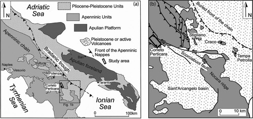
The drainage basin of the ‘Fiumarella di Corleto’ stream (FdC) resides in the external sector of the southern Apennines fold-and-thrust belt ((a,b)). The southern Apennines accretion wedge developed from the Upper Oligocene-Lower Miocene onwards as a result of the deformation towards NE of different Meso-Cenozoic paleodomains, originally located between the African and European passive margins (Patacca & Scandone, Citation2007 and reference therein).
Figure 1. (a) Geological sketch map of the southern Apennine (CitationBentivenga et al., 2004; Citation2015 mod.); (b) Tectonic sketch map of the front of the chain (CitationBentivenga et al., 2005 mod.). The rectangle indicates the study area.
The main units outcropping in this sector are represented by the Sannio and Sicilide units with associated Miocene and Pliocene thrust-top deposits (Patacca & Scandone, Citation2007) represented respectively by Gorgoglione Formation and the Sant’Arcangelo units. Other units are represented by the Torrente Cerreto Unit and Incertae Sedis deposits (see the tectono-stratigraphic organization proposed in the main geological Map).
The Sicilide and Sannio units mainly occur in the western slope of the FdC drainage basin where they form imbricate-fan structures (CitationBonini & Sani, 2000; CitationCarbone et al., 1991; CitationCavalcante F. et al., 2015; CitationLentini et al., 2002).
According to the existing literature (CitationBentivenga et al., 2015; CitationCarbone et al., 1988, Citation1991; CitationCavalcante et al., 2003, Citation2007, Citation2015; CitationLentini, 1979; CitationLentini et al., 2002) the Sicilide Unit sequence, exposed in the western and southern sectors of the study area, consist of: (i) Upper Cretaceous chaotic varicoloured shales including calcareous fragments, calcarenites and calcilutites pertaining to the Argille Varicolori Inferiori (Cav in the main geological map); (ii) Palaeocene calcareous marls, shales, calcilutites, calcarenites, rudstones and sandstones ((a)) pertaining to of the Monte Sant’Arcangelo Formation (Pc in the main geological map); (iii) Eocene-Oligocene shales, limestones, calcareous marls, clayey marls, shales and calcilutites with rare intercalations of the turbiditic arenaceous layers ((b)) pertaining to the Argille Varicolori Superiori Formation (EOav’ in the main geological map); (iv) Upper Oligocene – Lower Miocene lithic arkose arenites, calcilutites, calcarenites, marls and shales ((c)) pertaining to the Arenaria di Corleto (OMar in the main geological map).
Figure 2. Photographs of the main lithologies outcropping in the study area. (a) Monte Sant’Arcangelo Fm; (b) Argille Varicolori Superiori Fm: alternating shales and carbonates; (c) Arenarie di Corleto; (d) Flysch Rosso Auctorum p.p. Fm; (e) Varicoloured Clays (Torrente Cerreto Unit); (f) Gorgoglione Fm: Arenaceous-conglomerate; (g) Gorgoglione Fm: Arenaceous-pelitic lithofacies (sector 1), Clayey lithofacies (sector 2).
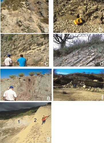
The Sannio Unit (CitationCavalcante et al., 2011 and reference therein) represents the detached Cretaceous-Miocene sequence of the Lagonegro basin (CitationCarbone et al., 1988; CitationPalladino et al., 2013) and, in the study area, is represented by Upper Cretaceous to Eocene alternance of calciturbidites and red clays ((d)) pertaining to the Flysch Rosso Auctorum p.p. (CEc in the geological main map); (CitationCavalcante et al., 2011; Patacca & Scandone, Citation2007).
The Torrente Cerreto Unit consists of Cretaceous to lower Miocene chaotic varicoloured clay and shales including blocks from older tectonic units. This unit is interpreted as an olistostrome (CMav in the main geological map) ((e)).
Incerte Sedis units consist of varicoloured clays and shales named as Undifferentiated Varicoloured Clays with uncertain stratigraphic position (COav in the main geological map).
The late Burdigalian to Tortonian Gorgoglione Formation (CitationBoenzi & Ciaranfi, 1970; CitationGiannandrea et al., 2016) is widely exposed in the north-eastern sector of the study area and unconformably lies above the deposits of the Sicilide Units (CitationLentini et al., 2002) (see the geological map in the Main Map).
The succession of the Gorgoglione Formation consists of turbiditic sandstones, pelites and subordinately conglomerates organized into three main turbidity systems (CitationBoiano, 1997). The entire sequence can reach a thickness of about 600 m; it can be divided into the following three stratigraphic intervals:
- the upper interval consists of grey sandstones, silty marls and grey clayey silts and polygenic conglomerates (Arenaceous-conglomeratic lithofacies) ((f) see ‘Mac’ in the geological map);
- the intermediate interval consists of alternating clayey silts, marly clays and greyish quartz-feldspathic sandstones (Arenaceous-pelitic lithofacies) (Sector 1 in (g) ‘Mar’ in the geological map);
- the lower interval consists of alternating blue-grey clayey silts and thin-bedded arenites (Clayey lithofacies) (Sector 2 in (g) ‘Mag’ in the geological map).
In the southern sector of the FdC drainage basin marine Pliocene yellowish sands with intercalations of sandstone layers (Ps in the main geological map) croup-out. These deposits pertain to the thrust-sheet top Sant’Arcangelo Basin (CitationCarbone et al., 1991).
The main tectonic structures are represented by a series of NNW-SSE oriented thrusts (CitationCarbone et al., 1991; CitationCavalcante F. et al., 2015; CitationLentini et al., 2002) and back-thrusts (CitationBonini & Sani, 2000; CitationCavalcante F. et al., 2015; CitationPiedilato & Prosser, 2005) exposed along both sides of the FdC (see the geological map in the Main Map). Along the right side of the FdC, the Sicilide Units tectonically overlie the Gorgoglione Formation through a major thrust fault. Splays of the main thrust surface cause the tectonic doubling of the units at the hanginwall. Along the left side, at the base of the Monte Tavernaro - Cima San Pietro Ridge, a series of NNW-SSE oriented back-thrusts cause the superimposition of undifferentiated varicoloured clay (referred to the Sannio and/or Sicilide Units) on the Gorgoglione Formation (Tempa Rossa Back-thrusts; CitationBonini & Sani, 2000; CitationPiedilato & Prosser, 2005), (see the cross-section A-A′ in geological map). Contractional structures are interrupted southward by the NW-trending Scorciabuoi Fault (CitationPatacca & Scandone, 2001) ((b)). This younger tectonic lineament is a left-lateral strike-slip fault of Early Pleistocene age, later reactivated as a normal fault (CitationCamarlinghi et al., 1994; CitationPieri et al., 1997).
3.2. Geomorphological setting of the study area
The FdC drainage basin area is oriented NNW-SSE and is located to North of the Corleto Perticara village. The area is characterized by a predominantly mountainous landscape and only the lower part of the drainage basin falls within the hilly altimetric belt. The closure point of the drainage basin is located SSE of the Corleto Perticara village. The main reliefs are represented to the north by Tavernaro Mount (1390 m a.s.l.) from which the NW-SE oriented Caperrino ridge starts, which delimits the north-eastern part of the entire catchment area of the ‘FdC’ (see the LIM map in the Main Map). Proceeding from NW towards SE along the Caperrino ridge, the main reliefs encountered are: Tempa San Nicola (1455 m a.s.l.), Burrone Petroso (1276 m a.s.l.), Balzo del Prete (1154 m a.s.l.), Cima San Pietro (1160 m a.s.l.) and in the SE sector Tempa di Fabio (736 m a.s.l.). On the left side of the ‘FdC’ we encounter Tempa Coriana (1132 m a.s.l.) to the NW and Tempa Lata (1303 m a.s.l.), Tempa Zaccanella (1131 m a.s.l.), Tempa Santa Maria (952 m a.s.l.) proceeding towards SE.
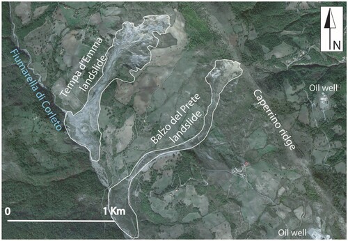
The south-eastern portion of the drainage basin largely coincides with clayey outcrops giving rise to gently inclined slopes which are affected by numerous landslides. The drainage basin area has a well-developed hydrographic network, with the main course which originates at the Tavernaro Mount and proceeds first towards SW (transverse or ‘anti-Apennine’ valley) and then, near San Michele, deviates towards the SE (longitudinal or ‘Apennine’ valley) until its confluences in the mainstream presented by the Sauro River (see the Main Map). The slopes are marked by numerous ditches characterized by active erosional processes. In many cases, the ditches delimit the medium-low part of the main landslide bodies. The erosional processes along watercourses and the widespread occurrence of landslides along the slopes could be related to the rapid tectonic uplift taking place in the area from the late Pliocene to the late Pleistocene (CitationSchiattarella et al., 2003). Numerous landslides have developed and many of them affect the entire slope, such as the Tempa d’Emma and Balzo del Prete landslides ().
Figure 3. Example of landslides affecting the left slope of the Fiumarella di Corleto (Google Earth image). The Tempa d’Emma and Balzo del Prete earth flows involve different lithologies and infrastructures such as buildings, roads, etc.
Landslides are mainly responsible for the shaping of the slopes and for this reason their census, classification and state of activity have been established. Most of the slope profiles are characterized by rough and accentuated morphologies, mainly due to lithological variations and landslides. In different areas of the FdC drainage basin, characterized by moderate slope acclivity, slow and shallow movements of the regolith, such as the solifluction, are evident. This affects slopes where clayey-silty lithologies are exposed. These rock-types, if subject to imbibition, tend to move along the slope giving rise to a landscape characterized by terraces and ripples. The landscape has also been modified by human activities, which included the use of mechanical devices in the last 50 years. The landscape has been modified by agricultural practices, the construction of numerous municipal roads, platforms for oil wells and other excavation works connected to the exploitation of hydrocabons in the area. Human activities are sometimes responsible for the slope destabilization.
4. Results and discussions
4.1. The Landslide Inventory Map
A LIM at a 1: 25,000 scale (see Main Map), classified by CitationGuzzetti et al. (2012) as a medium-scale landslide inventory, has been prepared.
Three main landslide typologies have been recognized: earth flows in clays, slides in sandstones and complex landslides (slides, in the upper part and flows in the lower-middle part of the slope as CitationVarnes, 1978) in both sandstones and clays (see LIM in Main Maps) ().
Table 1. Spatial distribution of the landslide typologies mapped in the study area.
We have investigated the interplay between predisposing factors (lithology, slope, aspect and land use) and landslides occurrence. Thus, for each class of the four different predisposing factors, a landslide index (I), expressed as the ratio in percentage between landslide area and total area [I = (Al/At) %] has been computed. Being a density index, it does not give information on the type of movement developed, but on the amount of area subjected to movement.
The dimensions of the landslides detected are very varied, there are landslides, attributable to different tipology, very small, with more or less elongated shapes and others of considerable size. The latter reach lengths of about 3 km and a width of 1 km and in some cases affect the entire slope (see LIM in Main Map).
The landslides, which affect the drainage basin of the FdC, have very different dimensions. Those with larger dimensions are mainly observed along the left side of the FdC where the clayey and arenaceous-pelitic lithologies emerge with greater extension. The slope of the left side is on average greater than that of the right side, while the exposure to the southern quadrants prevails. In addition, the land use map shows that along the left side there are fewer forest areas, compared to the right one and greater areal extension affected by agricultural processing (Classes 2 and 4) ().
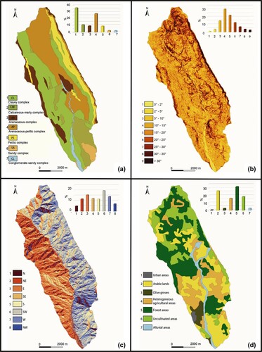
Figure 4. Thematic maps of the FdC drainage basin: (a) lithological map; (b) slope map; (c) aspect map; (d) land use map. Every map includes a histogram that shows the distribution, expressed in percentage, of different classes.
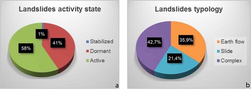
The LIM includes 551 landslides corresponding to an average density of 11.0 landslides for km2. The total extent of the area affected by landslides is 21.4 km2 corresponding to 42.8% of the total area. The complex landslides are more widespread, amounting to 42.7% of the landslides area, whereas the earth flows and slides correspond respectively to 35.9% and 21.4%.
The active, dormant and stabilized landslides percentage amounts to 58%, 41% and 1%, respectively ().
Figure 5. Pie chart representation of the percentages of landslide activities and different typologies. (a) Landslide activity state; (b) landslide typology. The percentages are calculated with respect to the total landslide area.
The lithology is the main predisposing factors, which promote the initiation and evolution of landslides processes. Based on their geotechnical behaviour, the outcropping geological units were grouped into seven lithological complexes: clayey, calcareous-marly, arenaceous, arenaceous-pelitic, pelitic, sandy and conglomerate-sandy complexes ().
Table 2. Correspondence between geological units and lithological complexes.
A lithological map has been constructed by grouping the different geological units into the lithological complexes listed above ((a)). This allowed the computation of the percentage of each lithological unit compared with the total area ((a)). The most widespread lithologies are the clayey and arenaceous-pelitic complex, corresponding to 36.7% and 28.1% of the total area, respectively. Conversely, the alluvial deposits and the sandy units correspond to 2.4% and 2.6%, respectively. The slope angle is considered one of the main parameter influencing the slope stability since it is closely linked to the acting forces. The histogram in (b) shows the slope class’s distribution, computed from DTM, compared to the total area. The most represented class ranges from 10° to 15° (class n. 4). The slope gradient is highest (>35°) along the eastern edge of the basin, at Tempa San Nicola and at Cima San Pietro, and near Tempa Lata, in correspondence of a very extensive landslides scarp edge.
The slope map also highlights some of the slope trends and in particular the slope variations mainly due to the different outcropping lithologies with different competence.
The slope aspect is an important landsliding predisposing factor because it affects the territory degradation. The aspect influences the vegetation cover on the slope, the daily range of temperature and relative humidity; all this involves a different degree of slope erosion ((c)). The histogram of the (c) shows the aspect class’s distribution, compared to the total area. It is evident that the slopes are exposed mostly to the southwest (18%), while only 4% of the total area is exposed to the north. The land use map ((d)) contains information related to pedological and anthropogenic factors that may contribute to the landslides triggering. For this reason, we have considered the soil classes’ distribution as an additional factor predisposing to landsliding. In (d), it is evident that the forest area, located in the north-western portion, is the most representative class, corresponding to 32% of the total area. Arable lands and uncultivated areas, along the eastern slope, correspond to 26% and 19% of the total area, respectively. Finally, the urban area only refers to the Corleto Perticara village and this is the least common class, corresponding to 1% of the total area.
4.2. Relationship between landslides types and lithologies
The influence of lithologies on the instability tendency can be ascertained by means of the landslide index, represented by the ratio in percentage between the landslide area excluding the overlapping areas and the total surface area of each lithology shows that the predominantly pelitic lithologies are those with a higher quantity of landslides ().
Figure 6. Histogram representing the landslide index vs lithological complex.
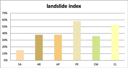
The distribution of a particular type of landslide is very diversified for each lithological unit ((a)). This allows us to observe how the percentages of the different types of landslides vary with respect to the lithological complexes shown in and (a). The complex landslides form in the Clayey (CL) and Calcareous-marly complex (CM) and in particular in the Pelitic complex (PE) and more rarely in the Sandy complex (SA). As regards the distribution of slides, these mainly concern the Arenaceous complex (AR), the Clayey (CL) and the Pelitic complex (PE) and in a minimal part the Calcareous-marly complex (CM). The earth flows affect mainly the Clayey (CL) and Pelitic complex (PE), while the percentage is reduced by only 3.25% in Sandy complex (SA).
Figure 7. Histograms representing the landslide typologies (a) and landslide activity state (b) vs lithological complex.
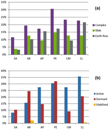
The state of activity of the landslides can be correlated with the different outcropping lithologies and the histogram highlights that the active landslides affect all lithologies and in particular the Clayey complex (CL) and Pelitic complex (PE) ((b)). The dormant landslides mainly affect Pelitic complex (PE) and Arenaceous complex (AR), although to a lesser extent they have been detected in all areas where the other lithologies are exposed. There are very few stabilized landslides and they have been recognized only in the Arenaceous complex (AR).
4.3. Relationship between landslides types and other predisposing factors
The considerable amount of data obtained in this research allows the definition of the relationship between the type of landslide movement and the three others predisposing factors considered. Following the same methodology used for the previous elaborations, the landslide index relating to every type of movement for the four predisposing factors, regardless of their significance has been determined. The data were represented on histograms where the landsliding predisposing factors classes are reported on the horizontal axis and the percentage of the landsliding area on the vertical axis ().
Figure 8. Landslides types distribution for lithological (a) slope steepness (b), aspect (c) and soil use (d) classes.
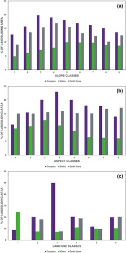
The percentage (%) of landsliding area versus slope gradient relationship has been plotted on (a). The graphical analysis shows different results for the several detected types of landslides.
The complex landslides and the earth flow bodies are generally well distributed for slope gradient higher than 2°, with the main peaks corresponding to the range 5–25°. This is because these types of landslides almost always affect all the hillslopes, from steepest areas (>25°) to the valley bottom. Slightly different is the behaviour of slides, which main occur on steepest slopes (>15–20°). The low values of % of landsliding are in correspondence of very low values of slope, highlighting that much of the slides do not reach the valley bottoms.
The percentage (%) of landsliding area versus aspect relation is reported on (b). It emerges that the slopes most affected by landslides are those exposed E, SE and S (classes 3, 4 and 5). The complex landslides are mainly present along the slopes exposed to E, SE and S (classes 3, 4 and 5), while slides occur in the first 4 classes and the earth flows are distributed fairly evenly in all classes. The landslide development on E to S oriented slopes is probably due to the lack of vegetation. Aspect affects solar radiation and the amount of heat energy taken from the sun and thus water loss by transpiration and evaporation which affects vegetation distribution and type. Moreover, also the low soil moisture of the area does not allow the growth of dense vegetation. Here main of the landslides have been triggered by low frequency/high magnitude rainfall events preceded by wet periods which have saturated the soil (CitationLazzari et al., 2018; Citation2020). The alternation of prolonged drought with multi-daily heavy rainfall events prevents the formation of luxuriant vegetation, leaving the soil defenceless and favouring the triggering of rapid movements. As previously said, earth flows also occurred with high frequency on northern slopes. In this case, the slopes are vegetated and the landslides are mainly triggered by moderate to high precipitation which are anticipated by very high soil moisture condition.
In (c) the relation between the percentage (%) of landsliding area and the land use is depicted. The peak value in correspondence with class 3 (olive groves), is a given unrepresentative view of the limited areal extent of this class. The complex landslides mainly affect classes 2, 4 and 6, while slides are numerous in class 1. Earth flows mainly affect classes 2, 4 and 6 to a lesser extent classes 3 and 5 and are absent in class 1.
The comparison between the lithological map ((a)), the slope map ((b)) and the distribution of the different landslide types ((a)), indicate that: (i) the earth-flow and complex landslides are more abundant in slope classes 3, 4 and 5, where the clay complex (CL) is present; (ii) the slides are more abundant in slope >15° (classes 5–9), where the more competent arenaceous lithologies (AR, AP) are widespread.
5. Conclusions
In this study, the relationship between landslides occurrence and several predisposing factors like lithology, slope steepness, aspect and land use in the Fiumarella di Corleto drainage basin, a very representative area of the Italian Southern Apennine chain has been investigated. Geomorphological analyses coupled with data processing in GIS environment allowed to characterize the spatial distribution, the type and the activity of landslides. As a final product, a LIM was created at a 1:25,000 scale, where are reported different sizes of landslides, their types and state of activity.
The LIM shows that the 551 surveyed landslides are distributed unevenly in the investigated about 50 km2 area, corresponding to an average density of 11.0 landslides for km2. The total extent of the area affected by landslides is 21.4 km2, which corresponds to 42.8% of the total area. The most common types of landslides are complex landslides, which amount to 42.7% of the landslides area, whereas the earth flows and slides correspond respectively to 35.9% and 21.4%. The active, dormant and stabilized landslides percentage amounts to 58%, 41% and 1%, respectively.
The interaction between the landslides density and the triggering factors has highlighted that clayey and pelitic lithologies significantly affect both the distribution and the typology of landslides, suggesting the general usefulness of always combining a detailed geological map to the LIM.
The LIM of the FdC drainage basin area provides basic data that can be used in subsequent studies to assess susceptibility and landslide hazard and to provide important indications for correct territory planning, especially in the Mediterranean area.
Software
The dataset of the map, including the symbols of the geomorphological legend, has been digitized and managed using ESRI ArcGIS 10.5 and the final map was made using CorelDraw 8.1.
Supplemental Material
Download Zip (7.4 MB)Acknowledgements
The authors thank Prof. Jan-Christoph Otto, Dr Mihai Micu, Dr Chandra Jayasuriya, Dr Mauro Cardinali and Prof. Daniela Piacentini for their critical comments and suggestions, which greatly improved the quality of our manuscript and map. We also acknowledge the contribution provided by Marilena Merlino during both field and laboratory work. The present work was funded by grants appointed to Mario Bentivenga.
Disclosure statement
No potential conflict of interest was reported by the authors.
Data availability statement
The data that support the findings of this study are openly available in ‘Figshare’ at https://doi.org/10.6084/m9.figshare.14959521.v1.
Additional information
Funding
References
- Bentivenga, M., Bellanova, J., Calamita, G., Capece, A., Cavalcante, F., Gueguen, E., Guglielmi, P., Murgante, B., Palladino, G., Perrone, A., Saganeiti, L., & Piscitelli, S. (2021). Geomorphological and geophysical surveys with In-SAR analysis applied to the Picerno earth flow (southern Apennines, Italy). Landslides, 18, 471–483. https://doi.org/10.1007/s10346-020-01499-z
- Bentivenga, M., Capolongo, D., Palladino, G., & Piccarreta, M. (2014). Geomorphological map of the area between Craco and Pisticci (Basilicata, Italy). Journal of Maps, 11(2), 267–277. https://doi.org/10.1080/17445647.2014.935501
- Bentivenga, M., Coltorti, M., Prosser, G., & Tavarnelli, E. (2004). Recent extensional faulting in the Gulf of Taranto area: Implications for nuclear waste storage in the vicinity of Scanzano Ionico (Basilicata). Bollettino della Societa Geologica Italiana, 123(3), 391–404.
- Bentivenga, M., Foresi, L. M., Prestera, A., Prosser, G., & Sabia, M. (2005). Structures located at the front of a thrust and fold belt: The Craco area (Southern Apennines, Italy). Bollettino della Societa Geologica Italiana, 124(2), 367–376.
- Bentivenga, M., Giocoli, A., Palladino, G., Perrone, A., & Piscitelli, S. (2019). Geological and geophysical characterization of the Brindisi di Montagna Scalo landslide (Basilicata, southern Italy). Geomatics, Natural Hazards and Risk, 10(1), 1367–1388. https://doi.org/10.1080/19475705.2019.1575291
- Bentivenga, M., Palladino, G., & Caputi, A. (2012). Development of the Pietra Maura landslide and interactions with the Marsico Nuovo dam (Basilicata – Italy). Geografia Fisica e Dinamica del Quaternario, 35(1), 13–22. https://doi.org/10.4461/GFDQ.2012.35.2
- Bentivenga, M., Palladino, G., Prosser, G., Guglielmi, P., Geremia, F., & Laviano, A. (2015). A Geological Itinerary through the Southern Apennine Thrust Belt (Basilicata-Southern Italy). Geoheritage, 9(1), 1–17. https://doi.org/10.1007/s12371-015-0168-6
- Bentivenga, M., & Piccarreta, M. (2016). Geomorphological map of Pisticci area (Basilicata, Southern Italy). Journal of Maps, 12(1), 220–226. https://doi.org/10.1080/17445647.2016.1193776
- Boenzi, F., & Ciaranfi, N. (1970). Stratigrafia di dettaglio del «Flysch di Gorgoglione» (Lucania). Memorie della Società Geologica Italiana, 9(1), 65–79.
- Boiano, U. (1997). Anatomy of a siliciclastic turbidite basin: The Gorgoglione lysch, upper miocene, southern Italy: Physical stratigraphy, sedimentology and sequence-stratigraphic framework. Sedimentary Geology, 107(3), 231–262. https://doi.org/10.1016/S0037-0738(96)00023-1
- Bonini, M., & Sani, F. (2000). Thrusting stike-slip faulting and syntectonic deposition in the Potenza- Guardia Perticara area (Basilicata, Southern Apennines, Italy). Bollettino della Societa Geologica Italiana, 55(1), 123–132.
- Camarlinghi, R., Patacca, E., Santini, U., Scandone, P., & Tozzi, M. (1994). Il Bacino di S. Arcangelo. Relazioni fra tettonica e sedimentazione. In Geologia delle aree di avampaese, 206–208. Riassunti 77° Cong. Naz. Soc. Geol. It., Bari.
- Carbone, S., Catalano, S., Lazzari, S., Lentini, F., & Monaco, C. (1991). Presentazione della carta geologica del Bacino del Fiume Agri (Basilicata). Memorie della Società Geologica Italiana, 47(1), 129–143.
- Carbone, S., Catalano, S., Lentini, F., & Monaco, C. (1988). Le unità stratigrafiche strutturali dell’alta Val d’Agri (Appennino Lucano) nel quadro dell’evoluzione del sistema Catena - Avanfossa. Memorie della Società Geologica Italiana,, 41, 331–341.
- Carrara, A., Cardinali, M., Guzzetti, F., & Reichenbach, P. (1995). GIS technology in mapping landslide hazard. In A. Carrara & F. Guzzetti (Eds.), Geographical information systems in assessing natural hazards (pp. 135–175). Kluwer Academic Publisher.
- Cavalcante, F., Belviso, C., Bentivenga, M., Fiore, S., & Prosser, G. (2011). Occurence of palygorskite and sepiolite in upper Paleocene – middle Eocene marine deep sediments of the Lagonegro basin (Southern Apennines–Italy): Paleoenvironmental and provenante inferences. Sedimentary Geology, 233(1–4), 42–52. https://doi.org/10.1016/j.sedgeo.2010.10.007
- Cavalcante, F., Fiore, S., Lettino, A., Piccarreta, G., & Tateo, F. (2007). Illite-smectite mixed layers in sicilide shales and piggy-back deposits of the Gorgoglione Formation (Southern Apeninnes): geological inferences. Bollettino della Società geologica italiana, 126(2), 241–254. 7 figs., 3 tabs.
- Cavalcante, F., Fiore, S., Piccarreta, G., & Tateo, F. (2003). Geochemical and mineralogical approaches to assessing provenance and deposition of shales: A case study. Clay Minerals, 38(3), 383–397. https://doi.org/10.1180/0009855033830105
- Cavalcante F., P., Agosta F, G., Belviso, C., & Corrado, G. (2015). Post-depositional history of the Miocene Gorgoglione Formation (Southern Apennines, Italy): inferences from mineralogical and structural analyses. Bulletin de la Société géologique de France, 186(4-5), 243–256. https://doi.org/10.2113/gssgfbull.186.4-5.243
- CLC. (2014). CORINE Land Cover Dataset for 1990–2000–2006 and Documentation. http://www.eea.europa.eu/data-and-maps/data/corine-land-cover-2006-raster-2
- Cruden, D. M., & Varnes, D. J. (1996). Landslide types and processes. In A. C. Turner & R. L. Schuster (Eds.), Landslides, investigation and mitigation. Special Report 247 (pp. 36–75). Transportation Research Board, National Research Council; National Academy Press.
- Giannandrea, P., Loiacono, F., Maiorano, P., Lirer, F., & Puglisi, D. (2016). Geological map of the eastern sector of the Gorgoglione Basin (southern Italy). Italian Journal of Geosciences, 135(1), 120–141. https://doi.org/10.3301/IJG.2015.05
- Guzzetti, F., Cardinali, M., & Reichenbach, P. (1994). The AVI project: A bibliographical and inventory of landslides and floods in Italy. Environmental Management, 18(4), 623–633. https://doi.org/10.1007/BF02400865
- Guzzetti, F., Cardinali, M., Reichenbach, P., & Carrara, A. (2000). Comparing landslide maps: A case study in the upper Tiber River Basin, Central Italy. Environmental Management, 25(3), 247–263. https://doi.org/10.1007/s002679910020
- Guzzetti, F., Malamud, B. D., Turcotte, D. L., & Reichenbach, P. (2002). Power-law correlations of landslide areas in entral Italy. Earth and Planetary Science Letters, 195(3–4), 169–183. https://doi.org/10.1016/S0012-821X(01)00589-1
- Guzzetti, F., Mondini, A. C., Cardinali, M., Fiorucci, F., Santangelo, M., & Chang, K. T. (2012). Landslide inventory maps: New tools for an old problem. Earth-Science Reviews, 112(1–2), 42–66. https://doi.org/10.1016/j.earscirev.2012.02.001
- Lazzari, M., & Gioia, D. (2016). Regional-scale landslide inventory, central-western sector of the Basilicata region (Southern Apennines, Italy). Journal of Maps, 12(5), 852–859. https://doi.org/10.1080/17445647.2015.1091749
- Lazzari, M., Gioia, D., & Anzidei, B. (2018). Landslide inventory of the Basilicata region (Southern Italy). Journal of Maps, 14(2), 348–356. https://doi.org/10.1080/17445647.2018.1475309
- Lazzari, M., & Piccarreta, M. (2018). Landslide disasters triggered by extreme rainfall events: The case of Montescaglioso (Basilicata, Southern Italy). Geosciences, 2018(8), 377. https://doi.org/10.3390/geosciences8100377
- Lazzari, M., Piccarreta, M., & Manfreda, S. (2018). The role of antecedent soil moisture conditions on rainfall-triggered shallow landslides, Nat. Hazards Earth Syst. Sci. Discuss. [preprint]. https://doi.org/10.5194/nhess-2018-371
- Lazzari, M., Piccarreta, M., Ray, R. L., & Manfreda, S. (2020). Modeling antecedent soil moisture to constrain rainfall thresholds for shallow landslides occurrence. In R. Ray & M. Lazzari (Eds.), Landslides – investigation and monitoring [internet] (Vol. 5, pp. 1–32). IntechOpen; 2020. Retrieved 2022 Apr 09. https://www.intechopen.com/chapters/72592
- Lentini, F. (1979). Le Unità Sicilidi della Val d’Agri (Appennino lucano). Geologica Romana, 18, 215–224.
- Lentini, F., Carbone, S., Di Stefano, A., & Guarnieri, P. (2002). Stratigraphical and structural constraints in the Lucanian Apennines (Southern Italy): tools for reconstructing the geological evolution. Journal of Geodynamics, 34(1), 141–158. https://doi.org/10.1016/S0264-3707(02)00031-5
- Pack, R. T., Tarboton, D. G., Goodwin, C. N., & Prasad, A. (2005). SINMAP 2 – A stability index approach to terrain stability hazard mapping. Utah State University.
- Palladino, G., Prosser, G., & Bentivenga, M. (2013). The geological itinerary of Sasso di Castalda: A journey into the geological history of the Southern Apennine thrust-belt (Basilicata-Southern Italy). Geoheritage, 5(1), 47–58. https://doi.org/10.1007/s12371-012-0073-1
- Patacca, E., & Scandone, P. (2001). Late thrust propagation and sedimentary response in the thrust-belt-foredeep system of the Southern Apennines (Pliocene- Pleistocene). Anatomy of an Orogene: Apennines and Adiyacent Mediterranean Basin, capitolo 23, 401-440. Kluwer Academic Publishers.
- Patacca, E., & Scandone, P. (2007). Geology of the Southern Apennines. Boll. Soc. Geol. It. (Ital. J. Geosci.), Spec. Issue, 7, 75–119, 14 figs., 1 pl., CROP-04 (ed. by A. Mazzotti, E. Patacca and P. Scandone).
- Piedilato, S., & Prosser, G. (2005). Thrust sequences and evolution of the external sector of a fold and thrust belt: example from the Southern Apennines (Italy). Journal of Geodynamics, 39(4), 386–402. https://doi.org/10.1016/j.jog.2005.02.001
- Pieri, P., Vitale, G., Beneduce, P., Ciaranfi, N., Doglioni, C., Gallicchio, S., Giano, S. I., Loizzo, R., Moretti, M., Prosser, G., Sabato, L., Schiattarella, M., Tramutoli, M., & Tropeano, M. (1997). Tettonica quaternaria nell’area bradanico-ionica. Il Quaternario, 10(2), 535–542.
- Schiattarella, M., Di Leo, P., Beneduce, P., & Giano, S. I. (2003). Quaternary uplift vs tectonic loading: A case-study from the Lucanian Apennine, southern Italy. Quaternary International, 101-102, 239–251. https://doi.org/10.1016/S1040-6182(02)00126-X
- Terhorst, B., & Kreja, R. (2009). Slope stability modelling with SINMAP in a settlement area of the Swabian Alb. Landslides, 6(4), 309–319. https://doi.org/10.1007/s10346-009-0167-2
- Trigila, A., Iadanza, C., & Spizzichino, D. (2010). Quality assessment of the Italian landslide inventory using GIS processing. Landslides, 7(4), 455–470. https://doi.org/10.1007/s10346-010-0213-0
- Varnes, D. J. (1978). Slope movement, types and processes. In R. L. Schuster & R. J. Krizek (Eds.), Landslides, analysis and control, Special Report 176 (pp. 11–33). Transportation Research Board, Commission on Sociotechnical Systems, National Research Council; National Academy of Sciences.