
ABSTRACT
Geological maps of tropical areas demand special challenges due to weathering conditions, mainly where relief has low variability. Most part of Paraná Magmatic Province is included in this scenario. An exception to this situation is the southeastern portion of the province, in the state of Rio Grande do Sul, Brazil. The stratigraphic disposition of volcanic units and the characteristics of erosion of each one caused the exposition of four identified plateaus, in which outcrop, from bottom to top: (1) basalts from Torres/Vale do Sol formations; (2) Caxias do Sul dacite; (3) Barros Cassal sequence; (4) Santa Maria rhyolite. The contacts were traced using SRTM images (through altitude and slope maps), integrating previously published semi- to detailed maps and geochemical database from our group. The resulting map (1:250,000) contributes to the volcano-stratigraphic knowledge of this huge province, and allows us to suggest the review of silicic units, initially called Palmas Formation.
1. Introduction
The Paraná Magmatic Province (PMP) is one of the greatest expressions of continental volcanism on Planet Earth, and preserves ca. 1,000,000 km2 of volcanic rocks (CitationFrank et al., 2009), which can commonly reach thicknesses greater than 1000 m (CitationAlmeida, 1987). About 90% of this province (in area) is located in Brazilian territory, occupying significant portions of the southern (Rio Grande do Sul, Santa Catarina and Paraná), southeastern (São Paulo and Minas Gerais) and center-western (Mato Grosso, Mato Grosso do Sul and Goiás) states. Tholeiitic basalts predominate, which form laterally expressive (estimated volume of ∼450,000 km3 for extrusive rocks in Brazilian territory; CitationFrank et al., 2009) but often discontinuous flows. They must have been, in large part, fed by dike systems, with central edifices notably rare (see CitationPacheco et al., 2018).
As in other Continental Flood Basalt provinces, the mapping of flow successions is specially challenging, given their petrographic and structural similarities. For this reason, geophysical tools are often used. Studies were successful using paleomagnetic secular variation (e.g. for Deccan, CitationChenet et al., 2009; for Paraná, CitationRaposo et al., 2023), for example. In addition, complex denudation and erosive processes placed during- and after- the main magmatic event (see AFT ages, CitationGallagher & Brown, 1999; CitationHueck et al., 2019 and references therein) were responsible for a significant varying loss of rock volumes throughout coast and country side of Brazil. In the case of the Paraná Magmatic Province, the intense weathering and the smooth relief of much of the occurrence area reflect the adverse conditions of elaborating a detailed geological map and, consequently, knowing the volcano-stratigraphy.
Since the first studies on the PMP in Brazil (e.g. CitationBellieni et al., 1986), the most detailed surveys have been carried out on its southern portion (e.g. CitationBellieni et al., 1986; CitationGarland et al., 1995), where steeper reliefs favor continuous exposures of the volcanic package over extensive sections. Thus, the most detailed knowledge about the stratigraphy, geochronology and architecture of the PMP volcanism in Brazil is concentrated in this region. Even so, studies are based on geological profiles obtained along the main roads that cross the volcanic pile. Some publications of detailed and semi-detailed scale maps of specific regions have been published in recent years by the Geological Survey of Brazil (CitationHorn et al., 2022), or as support for scientific investigations (CitationBarreto et al., 2014; CitationGuimarães et al., 2018; CitationJanasi et al., 2011; CitationPolo et al., 2018; CitationRossetti et al., 2018).
The volcanism in southern Brazil is characterized by the expressive occurrence of silicic rocks (dacites and rhyolites) of diversified compositions. They have been the focus of several studies given peculiar characteristics, and whose spatial and stratigraphic distribution was presented in a map of regional scale by CitationNardy et al. (2008). Not by chance, the record of this type of volcanism lies within a regional structure called Torres syncline (e.g. CitationWaichel et al., 2012): a large depression (ca. 400 km wide), with gutter form, and whose axis dip to the interior of the continent (NW). Although there is still a lack of understanding how exactly regional structures are distributed within the basin, and up to which point they are controlling the distribution of magmatism, at least since CitationAlmeida (1987) these NW-SE axes (South to North: Rio Grande Arch, Torres Syncline, Ponta Grossa Arch and Goiania Flexure) are recognized as big tectono-magmatic lineaments associated to the sedimentary and magmatic deposition/erosion during Paleozoic and Mesozoic. They also influenced the posterior cenozoic historic of denudation and erosion (e.g. CitationCogné et al., 2011; CitationHueck et al., 2019; CitationKarl et al., 2013).
Our initial studies in the Torres syncline focused on the silicic volcanism, and for that purpose were concentrated in the vicinities of Barros Cassal and Gramado Xavier towns (Rio Grande do Sul State), where a large number of outcrops were exposed by the construction of a highway. The first surveys revealed an important compositional variation, supported by petrographic and geochemical studies (CitationPolo et al., 2018; CitationPolo & Janasi, 2014a). Previously, regional maps only indicated the presence of rhyolites from the Santa Maria unit. By current chemical classification of silicic components of low-Ti sequence (Palmas type volcanism), Santa Maria corresponds to the SiO2-rich and TiO2-poor among six subtypes defined as Palmas Type (CitationGarland et al., 1995).
Importantly, chemical variations are expressed within stratigraphic limits, with pre-rhyolite sequences outcropping in valleys. The bottom of the valleys is occupied by dacites equivalent to the Caxias do Sul type (CitationGarland et al., 1995). They are, in several sections, separated from the rhyolites by a succession of thin flows of more primitive composition (andesites to dacites) hitherto unrecognized in the literature, and here referred as Barros Cassal Sequence (CitationPolo et al., 2018; CitationPolo & Janasi, 2014b). These ‘pre-rhyolite packages’ (including Barros Cassal sequence) are absent in certain regions and locally result in a direct contact between Santa Maria rhyolite and the Caxias do Sul dacite. Southward, the rhyolite outcrops directly in contact with basalt from Vale do Sol Fm, with the absence of dacites. Thus, in order to understand the spatial distribution of volcanic units and their relationships, it was necessary to carry out a mapping on a semi-detail scale, which resulted in the geological map at 1:100,000 published by CitationPolo and Janasi (2014a). Our later studies expanded into neighboring areas, aiming at understanding the distribution and compositional diversity of the Barros Cassal Sequence and the meaning of basic to intermediate volcanism in the province.
Volcanic rocks of different compositions and structures have different weathering characteristics (i.e resistance) due to surface physical–chemical processes, which in this case, might reflect the diverse contents of SiO2. The stratigraphic disposition at the area and the contrast of erosion patterns drew topographic ‘plateaus’, separated and highlighted by steep declivities. Systematic integration of chemical database, field surveys and semi-detail mapping (published by CitationPolo & Janasi, 2014a; located on the W-SW of the area) allowed the elaboration of a geological map of ca. 15,500 km2 area in the central-east portion of the Torres Syncline (Main Map).
2. Methods
2.1. Field surveys and chemical database
The geological map is based on systematic field surveys carried out by our group in successive campaigns between 2010 and 2019. The surveys were placed along the main access routes in the region, where good quality rock exposures are often found. Occasionally, outcrops in riverbeds and in active or abandoned quarries were studied. With the support from our geochemical database, soon to be published, the development of a remote technique based on the topographic signature was possible.
2.2. Geomorphology analysis – geoprocessing
SRTM (NASA Shuttle Radar Topography Mission) images were used to guide tracing contacts with three main products: 1. Elevation model; 2. Hypsometric map (intervals of 52 m; 15 classes) ((a)); 3. Slope map ((b)). Discontinuities and faults are inferred based mainly on the altitude of occurrence and comparison with chemical data, within topographically expressive lineaments (e.g. when the same unit appears at different altitudes at each side of the same drainage).
Figure 1. (a) Hypsometric map of classified altitudes, in intervals of 52 meters; (b) Slope map, that highlights 4 plateaus, indicated also in the geological sections; (c) Resulting geological map, after comparing geomorphologic patterns to geochemical and field data, besides integrating semi- to detailed maps within the area.
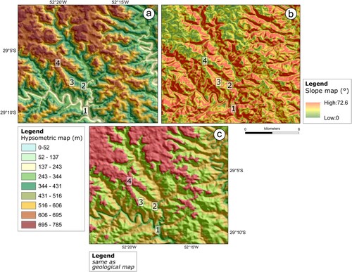
Four plateaus were identified for the whole area ((a)). They are separated by high slopes ((b)). The lowest one (, 1) comprises valleys and drainages in the northern part of the area, and gets progressively more expressive towards south. It marks the outcropping of basalts from Torres/Vale do Sol Fm. The second, third and fourth plateaus comprise Caxias dacite, Barros Cassal Sequence and Santa Maria rhyolite, respectively. It is important to note that units are not equally distributed, with discontinuities and hiatuses. The geological sections presented with the map also show the identified plateaus.
3. Geological map – explanatory note
3.1. Volcanic units
3.1.1. Torres and Vale do Sol formations
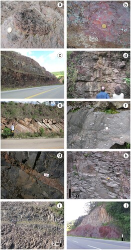
The mapped area is formed by volcanic rocks belonging to the Serra Geral Group and is dominated by silicic rocks. Earlier basalts occur only in the bottoms of the most carved valleys in its eastern part. In this portion, basalts from Torres and Vale do Sol formations ((a–d)), that are dominant in terms of volume, occupy valleys and become dominant to the south of the area. Whenever observed, basalts unveil structural and geochemical characteristics compatible with the Vale do Sol Fm.; although it is possible that in deeper portions of the valleys the Fm. Torres may be present, no outcrops clearly associated with it have been identified. These two units are undivided in this map.
3.1.2. Caxias do Sul dacite (CXd)
The Caxias do Sul-type dacite (CXd) ( and (e,f)) constitutes extensive deposits (apparently mostly lava flows and lava-domes; cf. CitationLima et al., 2012; CitationPolo et al., 2018). The unit was presumably erupted continuously during the initial stage, whereas, as recorded by the deposition of sandstone layers interleaved with the upper lava flows, a more intermittent eruptive behavior characterized the end of this event. Since it corresponds to the silicic rocks that occur over most of the area studied by CitationRossetti et al. (2018), and its stratigraphic position is consistent with their column, CXd is attributed here to the Palmas Fm.
Figure 2. Sketch of outcrop GX-410 (UTM 385040 E, 6768730 N; 22J; Pouso Novo-Lajeado section) showing the relationships between CX dacite and underlying andesite. Red circles indicate location of sampling.
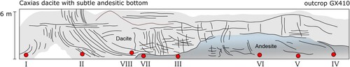
Figure 3. (a) Vesiculated basalt from Vale do Sol Fm., town of Herveiras; (b) Brecciated upper part of basalt from Vale do Sol Fm., town of Herveiras; (c) Pre-dacite basalt, Torres/Vale do Sol fms., West of Guaporé town; (d) Pahoehoe basalt of Torres Fm. with pipe vesicles; (e) Caxias dacite; (f) Vesiculated/amygdaloidal Caxias dacite; (g) Sandstone clastic dike within Barros Cassal dacite; (h) Santa Maria rhyolite; (i) Santa Maria rhyolite, town of Gramado Xavier; (j) Santa Maria rhyolite overlying directly pre-Caxias basalts, town of Herveiras.
In sections along the central and eastern part of the map, a layer of massive andesite is underlies the first CXd deposits (); when observed, the contact is subtle, and was only detected after systematic gammaspectrometric measurements throughout the exposure, complemented by petrography and geochemistry (see below). The composition of the dacite in this outcrop is more primitive, akin to the Jacuí type (CitationGarland et al., 1995; CitationNardy et al., 2008), which is a probable result of local interaction with the lower andesitic magma.
3.1.3. Barros Cassal succession
The Barros Cassal succession is formed by the emplacement of multiple lava flows with frequent intercalations of thin sandstone layers and lenses ((g)). It comprises a wide compositional range, from basalt to dacite, mostly with a well-defined trend of increasing silica content upwards; the more silicic rocks are more primitive than the CXd and occur exclusively in the western portion of the map (Gramado Xavier vicinities). The sequence changes eastward, as it tends to become more mafic (including basalts with up to 6 wt% MgO) and thicker (up to 200 m in the Guaporé region), while it is thinned or even absent to the west in places where the dome structures of the previous Caxias dacite sustained a more prominent relief. The sedimentary intercalations disappear eastward, suggesting that the border of the basin was located to the west during the deposition.
3.1.4. Santa Maria rhyolite (SMr)
The upper volcanic sequence is the Santa Maria rhyolite ((h–j)), an extensive and thick unit whose area of exposure is shown by regional maps (e.g. CitationNardy et al., 2008) to extend for at least 300 km to the west of our map along the axis of the Torres Syncline. In the mapped area, it may reach thicknesses up to 400 m, among the highest reported for this unit. In the western part of the map, the rhyolites usually rest directly on sandstones and volcanoclastic breccias (cf. CitationRiccomini et al., 2016). Western of longitude 53°30′W (CitationNardy et al., 2008), Santa Maria rhyolite is found directly over the Vale do Sol Fm., as the previous Caxias Dacite and Barros Cassal Fm. fade out.
In most of the exposures the flow base is formed by up to 5 m thick layer of black obsidian. The lower deposits of the SMr have frequent structures indicative of effusive character, including lava lobes, autobreccias and peperite (produced by lava-sediment interaction) which are described in detail in CitationPolo et al. (2018).
In terms of stratigraphy, Santa Maria rhyolite is here attributed to Arvorezinha Fm (from CitationHorn et al., 2022).
3.2. Agglomerates, breccias and sandstones at the base of SMr
The sandstones are red colored, immature (feldspar-rich), poorly selected, medium to coarse grained, with local conglomerate facies. They show some primary structures, such as plane-parallel layering and small to medium-scale cross-stratification ((g); clastic dike, sandstone cutting Barros Cassal unit). These structures and the presence of coarse facies and clasts (5–10 cm) dispersed in sandy matrix are suggestive of lacustrine-alluvial environments. Locally, these sandstones interacted with the rhyolite lavas of the Santa Maria forming peperites. An alternative explanation for the origin of some sedimentary rocks in the southern Paraná as sand injectites and extrudites was proposed by CitationDuarte and Hartmann (2014), but CitationPolo and Janasi (2014b) argued for a syn-volcanic origin of the occurrences in the mapped area on the bases of field and mineralogical evidence.
4. Discussions and final remarks
The most recent stratigraphic proposal for the Torres Syncline region (CitationRossetti et al., 2018) includes all the silicic volcanic rocks in a single stratigraphic unit, the Palmas Fm. It overlaps the initial basaltic sequences, represented by the Torres (pahoehoe basalts) and Vale do Sol (rubbly pahoehoe basalts and andesites) formations, and is succeeded by basalts from the Esmeralda Formation. Grouping of the entire silicic rock pack in the Palmas Fm. proved to be questionable. In fact, as originally verified in the map by CitationPolo and Janasi (2014b), the Caxias do Sul dacite and the Santa Maria rhyolite occupy different stratigraphic positions, and are separated over practically the entire area of the map by an expressive pack of more mafic rocks of the Barros Cassal sequence. We propose here a threefold division of the upper volcanic sequence of the Torres Syncline where the silicic rocks occur ().
Figure 4. Stratigraphy of the volcanic units from the Paraná Magmatic Province in the area of the map, referred to the stratigraphic columns adopted by CitationRossetti et al. (2018) and CitationHorn et al. (2022) and to the paleomagnetic polarities obtained in the region by CitationRaposo et al. (2023).
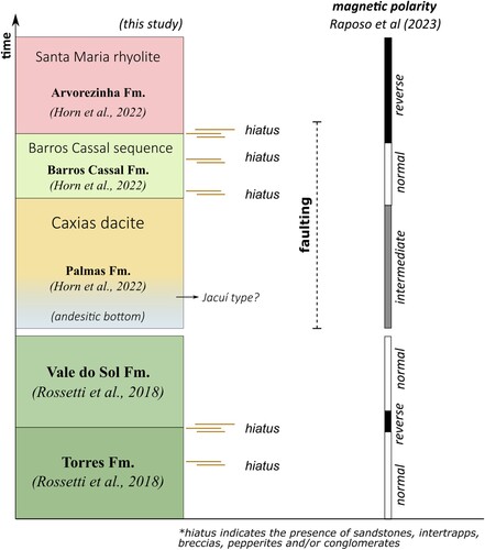
The Caxias do Sul dacite immediately overlaps the Vale do Sol Formation, and in the central part of the map area has an andesite layer at its base (andesitic bottom; and ). A diffuse contact with this andesite and a more primitive character of the dacites that are immediately above it in the Pouso Novo section suggests some interaction between the two magmas. Moreover, the Jacuí-type dacites reported in the regional literature (e.g. CitationNardy et al., 2008) appear to occur in this same stratigraphic position, and possibly has an origin similar to these ‘contaminated’ Caxias dacites.
The Santa Maria rhyolite is and independent stratigraphic unit, and is almost always separated from the Caxias dacite by a succession of mafic to intermediate lava flow, which is here proposed to comprise a separate unit, named Barros Cassal Formation. This unit shows important compositional variation from the west to the east portion of the map area: more evolved terms (dacites) cease to occur, basalts and andesites predominate and a layer of primitive basalts appears the basis of the sequence. These primitive basalts are chemically similar to the Esmeralda type basalt of CitationPeate (1997), suggesting a possible correlation between the Barros Cassal Fm. and the Esmeralda Fm. of CitationRossetti et al. (2018), to be investigated in future surveys.
As demonstrated here and by others, volcanoclastic rocks (named Jacuí Group by CitationRiccomini et al., 2016; see also CitationPolo & Janasi, 2014a,b) and an up to 10 m thick layer of sandstone occur locally at the base of Santa Maria rhyolite. Thin (< 5 m thick) layers of vitrophyre are common, especially at the lower portions of the unit. A thick monotonous, compositionally homogeneous, platy granular rock which at least in part may have a pyroclastic origin (compare CitationLuchetti et al., 2018; CitationPolo et al., 2018). Paleomagnetic studies (CitationErnesto et al., 1990; CitationRaposo et al., 2023; ) systematically show a reverse polarity for this unit.
Inferred faulting appears to be placed in between deposition/erosion of volcanic units, but before the deposition of the Santa Maria rhyolite. When mapped, units are subjected to abrupt discontinuities, changes in topography, hiatus indicators (intertrapps, breccias, conglomerates with chards and glass content). None indicative of faulting is observed in the field whatsoever, which could suggest an irregular filling pattern since pre-Caxias basic units.
Software
Geoprocessing was performed using ESRI ArcMap® software.
geological_map.pdf
Download PDF (16.3 MB)Acknowledgements
The authors would like to thank Francisco Negri (IG/IPA) for helping in fieldwork campaigns, Samuel Egidio and José Paulo Sertek for helping preparing and analyzing the material, and Renato Henrique Pinto (IGc-USP) for the supporting positively our ideas. The authors also thank the constructive comments and suggestions provided by the reviews of Leo Afraneo Hartmann and Lucas Rossetti, which considerably improved the final version of this manuscript.
Disclosure statement
No potential conflict of interest was reported by the author(s).
Data availability statement
The authors confirm that the data supporting the findings of this study are available within the article and its supplementary materials.
Additional information
Funding
References
- Almeida, F. F. M. (1987). Distribuição Regional E Relações Tectônicas Do Magmatismo Pós-Paleozoico No Brasil. Revista Brasileira de Geociências, 17(1), 325–349. https://doi.org/10.25249/0375-7536.1986325349
- Barreto, C. J. S., de Lima, E. F., Scherer, C. M., & Rossetti, L. d. M. M. (2014). Lithofacies analysis of basic lava flows of the Paraná igneous province in the south hinge of Torres Syncline, Southern Brazil. Journal of Volcanology and Geothermal Research, 285, 81–99. https://doi.org/10.1016/j.jvolgeores.2014.08.008
- Bellieni, G., Comin-chiaramonti, P., Marques, L. S., Melfi, A. J., Nardy, A. J. R., Papatrechas, C., Piccirillo, E. M., Roisenberg, A., & Stolfa, D. (1986). Petrogenetic aspects of acid and basaltic lavas from the paran plateau (Brazil): Geological, mineralogical and petrochemical relationships. Journal of Petrology, 27(4), 915–944. https://doi.org/10.1093/petrology/27.4.915
- Chenet, A.-L., Courtillot, V., Fluteau, F., Gérard, M., Quidelleur, X., Khadri, S. F. R., Subbarao, K. V., & Thordarson, T. (2009). Determination of rapid Deccan eruptions across the Cretaceous-Tertiary boundary using paleomagnetic secular variation: 2. Constraints from analysis of eight new sections and synthesis for a 3500-m-thick composite section. Journal of Geophysical Research: Solid Earth, 114(6), B06103. https://doi.org/10.1029/2008JB005644
- Cogné, N., Gallagher, K., & Cobbold, P. R. (2011). Post-rift reactivation of the onshore margin of southeast Brazil: Evidence from apatite (U-Th)/He and fission-track data. Earth and Planetary Science Letters, 309(1-2), 118–130. https://doi.org/10.1016/j.epsl.2011.06.025
- Duarte, S. K., & Hartmann, L. A. (2014). Discussion: “Volcanic stratigraphy of intermediate to acidic rocks in Southern Paraná Magmatic Province, Brazil” by Polo and Janasi (2014), Geologia USP. Série científica, 14, 83–100. Geologia USP - Serie Cientifica, 14(4), 99–100. https://doi.org/10.5327/Z1519-874X201400040006
- Ernesto, M., Pacca, I. G., Hiodo, F. Y., & Nardy, A. J. R. (1990). Palaeomagnetism of the Mesozoic Serra Geral formation, Southern Brazil. Physics of the Earth and Planetary Interiors, 64(2-4), 153–175. https://doi.org/10.1016/0031-9201(90)90035-V
- Frank, H. T., Gomes, M. E. B., & Formoso, M. L. L. (2009). Review of the areal extent and the volume of the Serra Geral Formation, paraná Basin, South America. Pesquisas Em Geociencias, 36(1), 49–57. https://doi.org/10.22456/1807-9806.17874
- Gallagher, K., & Brown, R. (1999). The Mesozoic denudation history of the Atlantic margins of Southern Africa and southeast Brazil and the relationship to offshore sedimentation. Geological Society, London, Special Publications, 153(1), 41–53. https://doi.org/10.1144/GSL.SP.1999.153.01.03
- Garland, F., Hawkesworth, C. J., & Mantovani, M. S. M. (1995). Description and petrogenesis of the paraná rzhyolites, Southern Brazil. Journal of Petrology, 36(5), 1193–1227. https://doi.org/10.1093/petrology/36.5.1193
- Guimarães, L. F., De Campos, C. P., Janasi, V. A., Lima, E. F., & Dingwell, D. B. (2018). Flow and fragmentation patterns in the silicic feeder system and related deposits in the Paraná-Etendeka Magmatic Province, São Marcos, South Brazil. Journal of Volcanology and Geothermal Research, 358, 149–164. https://doi.org/10.1016/j.jvolgeores.2018.03.021
- Horn, B. L. D., Oliveira, A. A., Simões, M. S., Besser, M. L., & Araújo, L. L. (2022). Projeto geologia e potential mineral da Bacia do Paraná. Mapa geológico. Porto Alegre. SBG/CPRM. Escala, 1, 1000000.
- Hueck, M., Dunkl, I., Oriolo, S., Wemmer, K., Basei, M. A. S., & Siegesmund, S. (2019). Comparing contiguous high- and low-elevation continental margins: New (U-Th)/He constraints from South Brazil and an integration of the thermochronological record of the southeastern passive margin of South America. Tectonophysics, 770(August), 228222. https://doi.org/10.1016/j.tecto.2019.228222
- Janasi, V. d. A., de Freitas, V. A., & Heaman, L. H. (2011). The onset of flood basalt volcanism, Northern Paraná Basin, Brazil: A precise U-Pb baddeleyite/zircon age for a Chapecó-type dacite. Earth and Planetary Science Letters, 302(1-2), 147–153. https://doi.org/10.1016/j.epsl.2010.12.005
- Karl, M., Glasmacher, U. A., Kollenz, S., Franco-Magalhaes, A. O. B., Stockli, D. F., & Hackspacher, P. C. (2013). Evolution of the South Atlantic passive continental margin in southern Brazil derived from zircon and apatite (U-Th-Sm)/He and fission-track data. Tectonophysics, 604, 224–244. https://doi.org/10.1016/j.tecto.2013.06.017
- Lima, E. F., Philipp, R. P., Rizzon, G. C., Waichel, B. L., & De Magalhães May Rossetti, L. (2012). Sucessões vulcânicas, modelo de alimentação e geração de domos de lava ácidos da Formação Serra Geral na região de São Marcos-Antônio Prado (RS). Geologia USP. Série Científica, 12(2), 49–64. https://doi.org/10.5327/Z1519-874X2012000200004
- Luchetti, A. C. F., Nardy, A. J. R., & Madeira, J. (2018). Silicic, high- to extremely high-grade ignimbrites and associated deposits from the Paraná Magmatic Province, southern Brazil. Journal of Volcanology and Geothermal Research, 355, 270–286. https://doi.org/10.1016/j.jvolgeores.2017.11.010
- Nardy, A. J. R., Machado, F. B., & Oliveira, M. A. F. d. (2008). As rochas vulcânicas mesozóicas ácidas da Bacia do Paraná: litoestratigrafia e considerações geoquímico-estratigráficas. Revista Brasileira de Geociências, 38(1), 178–195. https://doi.org/10.25249/0375-7536.2008381178195
- Pacheco, F. E. R. C., De Andrade Caxito, F., De Moraes, L. C., Pedrosa-Soares, A. C., & Queiroga, G. N. (2018). Geochemistry of basaltic flows from a basalt ring structure of the Serra Geral formation at Água Vermelha dam, Triângulo Mineiro, Brazil: Implications for the magmatic evolution of the Paraná-Etendeka Province. Brazilian Journal of Geology, 48(2), 283–304. https://doi.org/10.1590/2317-4889201820170084
- Peate, D. W. (1997). The Paraná-Etendeka province. Geophysical Monograph Series, 100, 217–245. https://doi.org/10.1029/GM100p0217
- Polo, L. A., Giordano, D., Janasi, V. A., & Guimarães, L. F. (2018). Effusive silicic volcanism in the Paraná Magmatic Province, South Brazil: Physico-chemical conditions of storage and eruption and considerations on the rheological behavior during emplacement. Journal of Volcanology and Geothermal Research, 355, 115–135. https://doi.org/10.1016/j.jvolgeores.2017.05.027
- Polo, L. A., & Janasi, V. A. (2014b). Reply to the Discussion by Duarte and Hartmann on “ Volcanic stratigraphy of intermediate to acidic rocks in southern Paraná Magmatic Province, Brazil “ by Polo and Janasi (2014). Geologia USP. Série Científica, 101–105. https://doi.org/10.5327/Z1519-874X201400040007
- Polo, L. A., & Janasi, V. d. A. (2014a). Volcanic stratigraphy of intermediate to acidic rocks in southern Paraná Magmatic Province, Brazil. Geologia USP. Série Científica, 14(2), 83–100. https://doi.org/10.5327/Z1519-874X201400020005
- Raposo, M. I. B., Pescarini, T., Guimarães, L. F., & Esteves, M. C. B. (2023). New magnetostratigraphy constrains in the southern Paraná magmatic province (Herveiras and Gramado Xavier areas), Rio Grande do Sul state, South Brazil: Implications for the timing between volcanic sources. Journal of South American Earth Sciences, 126(March), 104327. https://doi.org/10.1016/j.jsames.2023.104327
- Riccomini, C., Sant’Anna, L. G., & Fambrini, G. L. (2016). The early cretaceous Jacuí Group, a newly discovered volcaniclastic–epiclastic accumulation at the top of the Paraná Basin, southern Brazil. Cretaceous Research, 59, 111–128. https://doi.org/10.1016/j.cretres.2015.10.020
- Rossetti, L., Lima, E. F., Waichel, B. L., Hole, M. J., Simões, M. S., & Scherer, C. M. S. (2018). Lithostratigraphy and volcanology of the Serra Geral Group, Paraná-Etendeka Igneous Province in Southern Brazil: Towards a formal stratigraphical framework. Journal of Volcanology and Geothermal Research, 355, 98–114. https://doi.org/10.1016/j.jvolgeores.2017.05.008
- Waichel, B. L., de Lima, E. F., Viana, A. R., Scherer, C. M., Bueno, G. V., & Dutra, G. (2012). Stratigraphy and volcanic facies architecture of the Torres Syncline, Southern Brazil, and its role in understanding the Paraná-Etendeka Continental Flood Basalt Province. Journal of Volcanology and Geothermal Research, 215–216, 74–82. https://doi.org/10.1016/j.jvolgeores.2011.12.004