

ABSTRACT
In this study, we present a spatially explicit bayesian model which is able to predict the distribution of potential fire ignition at a grid resolution of over the entire main island of New-Caledonia. This statistical model, when used in conjunction with a mechanistic fire model (FlamMap), is able to estimate the comparative and spatialized risk of fire impact on specific areas for specific issues such as biodiversity or erosion. The input data includes variables related to the physical environment such as the topography, climate, and some geographical indicators relating to human influences such as population density and type of land property.
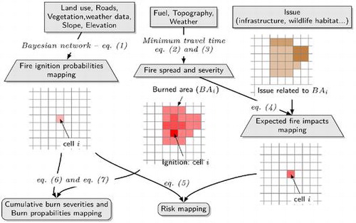
Flowchart computation for the specific cell i. The grey rectangles denote the input data, the trapezoids denote the intermediate indices and the rounded corners rectangles denote the integrated wildfire risk indices. The connection legends indicates the corresponding equations and below certain nodes a drawing describes an example related to the main variables and the associated area used.
Graphical Abstract
Notes
No potential conflict of interest was reported by the authors.