Abstract
A growing number of educators worldwide have become convinced that geotechnologies – including geographic information systems (GIS), global positioning systems (GPS), and remote sensing – are key technologies to prepare students to be tomorrow's decision makers. Grappling with local, regional, and global issues of the 21st century requires people who think spatially and who can use geotechnologies. Some educators teach geotechnologies as a discipline, emphasising skills. Other educators use geotechnologies as a tool to teach content, such as geography, history, environmental studies, Earth Science, biology, mathematics, economics and other disciplines. Issues such as traffic, population growth, urban sprawl, energy, water, crime, human health, biodiversity and sustainable agriculture are growing in complexity, exist at every scale and increasingly affect people's everyday lives. Each of these issues has a spatial component. Drivers for geotechnology education include educational content standards, constructivism, the school-to-career movement, active learning, citizenship education, authentic practice and assessment, interdisciplinary education, community connections and a sustained, increasing demand for GIS professionals. Digital Earth is an ideal framework for contextualising domains of inquiry. The Digital Earth community can have a significant impact on the growth of geotechnologies in education, and conversely, the growth of geotechnologies in education and society can foster the forward movement of Earth systems concepts.
Education about the Earth
The 500 scientists, engineers, educators, managers and entrepreneurs who created the Beijing Declaration on the Digital Earth were united in their recommendation that the Digital Earth ‘be promoted by scientific, educational and technological communities, industry, governments, as well as regional and international organisations’ (Xu and Chen Citation1999). The declaration emphasised ‘understanding the oneness of the Earth and its relevant phenomena.’ It called for ‘adequate investments and strong support in ‘scientific research and development, education and training.’ Education was therefore fundamental to the original Digital Earth concept and remains so today, evidenced by the numerous educational papers and workshops presented at each biennial Symposium on Digital Earth and by the articles in the International Journal of Digital Earth. Since the Digital Earth community as promoted by the International Society for Digital Earth and others seek to promote a sustainable planet, it must also educate people about the planet. If the community can help educate how and why the planet works the way it does, more people will appreciate the Earth's complexity and be interested in sustaining and protecting the Earth. David Orr (Citation1994) stated that the crisis we face in the world is the result of inadequate and misdirected education. Earth systems education should target not only students at all levels in formal learning settings, from primary to secondary to university, but should also target nonformal education, such as libraries, museums, environmental and other education organisations, and after-school groups. Finally, any Earth systems education program must include the general public to ensure broad support and promotion throughout society.
What to teach about the Earth
Given that education is vital to the Earth systems education, what should be the focus of this education for a subject as large and diverse as Planet Earth? I submit the following themes as fundamental to Earth systems education.
-
A global perspective (Merryfield et al. Citation1997, Libarkin et al. Citation2006) is as important as the content; in other words, how to think frames processing of the content.
-
Because the Beijing declaration acknowledged that humankind ‘still faces great challenges’ (Xu and Chen Citation1999), we must teach what those challenges are and why they are growing in seriousness on a global scale while also impacting people's everyday lives. These challenges should focus on those mentioned in the original declaration, such as rapid population growth, environmental degradation, natural resource depletion and sustainable development. A logical starting point would be instruction on the Earth-Sun system and how this system drives the Earth's atmosphere, lithosphere, cryosphere, and hydrosphere, and how it affects the Earth's anthroposphere (human systems). Specific topics to describe these challenges could be historical and current energy production, water quality and availability, coastal erosion, agriculture, land use and land development, urban settlement and forms, climate and weather, human health and behaviour, river systems, watersheds, and groundwater, ocean life and currents, biomes, ecotones, and ecoregions, plants and animals, historical and current human population, settlement, migration, and demographics, plate tectonics, volcanism and earthquakes.
-
The third component critical in teaching about the Earth as a system should be concepts, such as biodiversity, conservation, stewardship and sustainability. These broad concepts are the underpinnings of understanding the Earth holistically. These concepts imply affective education, impacting not only what students know, but also developing their own values and feelings about these issues, eventually leading to choices on what actions they may take or not take regarding them.
-
The fourth component important in teaching about Earth systems is processes, such as biogeochemical cycles, symbioses, the water cycle, the nitrogen cycle, the carbon cycle, eutrophication, ecological succession, migration of people, plants, and animals, the radiation budget, salinisation, mutualism, neutralism and photosynthesis, to name just a few. Rather than simply describing the Earth, educating about processes explains how the Earth works. It is critical that we teach how different systems on the Earth work together, why these systems must be balanced for a sustainable planet, and what happens when they are out of balance.
-
Learners need to understand how decisions are made about the environment, and therefore, environmental law, planning and zoning, and other legal and political concepts need to be included so that these future decision-makers can work within existing rules and laws, and if necessary, change them.
-
Threaded through any effective teaching about the Earth is the dynamic nature of the planet. Everything on, over, and under the Earth is in a continual state of change – ranging from slow changes such as plate movement along a fault line and mountain building to rapid change in wildfires, urban sprawl, and tsunamis.
-
The impact of 6.5 billion humans as change agents must be emphasised. Everything that humans do, from creating impervious surfaces in conjunction with urban sprawl, to the release of fossil fuel emissions into the atmosphere, to clearing land for agriculture, has profound and sometimes irreversible consequences on our planet.
-
An effective Earth systems educational program should focus on spatial thinking, so that learners will understand spatial patterns, linkages, and relationships. Some have made a distinction between geospatial thinking and spatial thinking, arguing that the former is a subset of the latter (Golledge et al. Citation2008). Sometimes these concepts are embedded in courses named ‘graphicacy,’ but even when this occurs, these concepts have often been at lower priority to curriculum planners compared to numeracy and literacy. Spatial thinking is a common element in all Earth systems sciences, such as geology, geography, and environmental studies, and even in other disciplines, such as epidemiology, business marketing, and certain branches of mathematics, and is essential to teaching about the Earth (Kerski Citation2004a, Bednarz et al. Citation2008).
How to teach about the Earth
Since effective Earth systems education teaches about the entire Earth – its processes, concepts, and interaction of multiple systems – what disciplines should be involved? Possible homes for Earth systems education are in Earth sciences, such as geography, geology, and environmental sciences. Geography is a spatial science concerned with how the environment affects people, and how people affect the environment. Geography may come closest of any discipline to encompassing many of the key components of Earth systems education, because of its concern with scale, movement, regions, human–environment interaction, location, and place, through its two roots of physical geography and cultural geography. The declaration makes a point of specifying that issues are not only environmental, but social and economic as well, all of which find a home in geography. However, a chief challenge is that in many countries, geography is not extensively taught in the primary and secondary curriculum (Kerski Citation2004a). Earth System Science offers another avenue. Earth Systems Science examines the Earth as interacting spheres of processes and phenomena, embracing chemistry, physics, biology, mathematics, and applied sciences to understand the Earth as a system (Johnson et al. Citation1998). However, Earth Systems Science is taught even less frequently than geography, including at university level. In most countries, education has been segmented in the past 150 years at the primary, secondary, and tertiary levels into discrete disciplines where it has become logistically difficult to teach interdisciplinary topics such as the Earth systems. In addition, short class periods pose challenges for investigative projects, especially those that include field work. However, the increasing interconnectedness of our world environmentally, politically, economically, and socially is beginning to place pressure on educational systems to incorporate not only new topics, but pressure to change the entire educational structure. Because the concepts of the Digital Earth are embedded in many different disciplines, the best approach to teach about the Earth as a system in education is not through any single discipline at all, but in an interdisciplinary manner. The Digital Earth can therefore be a change agent in education.
One might argue that Earth systems education has always been a part of aboriginal ways of teaching and learning (Kemp et al. Citation2008). Spatial technologies are aligned well to Native ways of learning and knowing, and thus have been adopted by many aboriginal peoples around the world (Kerski Citation2006). However, for many, Earth systems education is a new concept. While learners need to understand the fundamentals of how the Earth works, many advocate that those who teach about Earth systems need to do so in a new way. Teaching with technology must be done in a way that is culturally sensitive and adaptable by the diverse global community. It needs to include fewer lectures and more engagement of students through hands-on, problem-based investigation using real world tools in an inquiry-driven environment using real-world data. Learners should be encouraged to grapple with problems in such a way that they begin to think about improving the quality of human life and sustainability of the planet. Many advocate that investigation of phenomena and processes cannot take place entirely in a computer lab – outdoor education is essential for sustainability education (Nicol Citation2003)
What technologies should be used to teach about the Earth? The Digital Earth is ‘a virtual representation of the planet,’ that encompasses ‘all its systems and forms,’ (Xu and Chen Citation1999) one of the best ways to teach about the Earth may be through the same tools in which the Earth is modelled, via geotechnologies. Geotechnologies include geographic information systems (GIS), global positioning systems (GPS) and remote sensing (RS). The Beijing Declaration cited the importance of geotechnologies in modelling the planet, through ‘multi-dimensional, multi-scale, multi-temporal, and multi-layer information.’ During the 1960s, GIS was created to analyse problems in this very way, by organising the Earth's features into different thematic layers and then using computer-based tools to aid in examining their pattern, linkages, and relationships. Those learning about the Earth as a system should have the chance to view, analyse, and manipulate rich data sets from local to global scales, including such data about elevation, geology, biomes, population, climate, geology, land cover, using powerful two- and three-dimensional visualisation and analytical software. The ‘Global Spatial Data Infrastructure’ referred to in the declaration can be grappled with in a tangible way by designing projects that require students to use a variety of data sets within GIS and RS software to solve real-world problems. GIS has been effectively used in education for several decades, and while some challenges remain, its use offers great promise for teaching and learning about the Earth.
GIS in education
During the 1960s, when R. Buckminster Fuller began writing about the vision and concept of a Digital Earth (Anker Citation2007, Fuller Citation1963), GIS began to quietly transform how decisions are made in universities, government, and industry by bringing digital spatial data sets and geographic analysis to the computer environment. Not long after GIS began, organisations realised that a massive training effort was needed to equip people with the skills needed to effectively use GIS software and how to model the Earth in a GIS. At first, the training was almost entirely focused on how to operate GIS software, because that software posed a steep learning curve for most people. Furthermore, it could only be run on specialised mainframe and minicomputers, and only after 20 years, on personal computers, which limited the trainees in GIS to universities and large government organisations. During the 1980s, as GIS matured, a greater emphasis was placed upon the education about the organisational and management aspects of GIS. At the same time, as GISystems became a part of Geographic Information Science by the early 1990s (Goodchild Citation1992), the theory of how data could be represented spatially within a GIS and other theoretical underpinnings of GIScience became a major piece of GIS instruction. After 2000, spatial thinking began to be emphasised as necessary, alongside learning software, methods, and theory so that decision makers would understand spatial relationships and concepts in order to use GIS more effectively. At the same time, web-based GIS (Kerski Citation2008) and virtual globes (Schultz et al. Citation2008) greatly expanded the arsenal of geospatial tools available to the educator.
Teaching with GIS, teaching about GIS to understand the Earth
During these decades, two methods of teaching GIS evolved (Sui Citation1995). Teaching about GIS means to study GIS as the discipline of Geographic Information Science. Teaching about GIS provides a theoretical and practical foundation for careers in geographic information sciences, and includes such topics as database design, data standards, and data modeling. By 2008, GIS courses, degree programs, and certificates were available at nearly every major university around the world, at many technical colleges, and in hundreds of online programs. By 2004, these courses were taken by over 100,000 students annually (Phoenix Citation2004), who studied not only Geographic Information Science but a broad array of disciplines including environmental studies, business, geography, biology, engineering, Earth Science, planning, and others. Teaching about GIS dominates in higher education, although GIS courses are increasingly appearing at the secondary level and in nonformal educational programmes.
As GIS became easier and more practical to use, other educators began to use it in their own disciplines, such as biology, geography, Earth Science, chemistry, history, mathematics, and even language arts. Teaching with GIS began at the primary and secondary level by educators who wanted to help their students learn about plate tectonics, biomes, climate, migration, history, or other geographic topics and issues, but has been spreading across departments at the university level and on university campuses. Teaching with GIS involves its use as a tool to aid instruction in established disciplines. GIS was more affordable than paper maps, more customisable, more portable, and allowed students to more quickly move from looking at maps to analysing data.
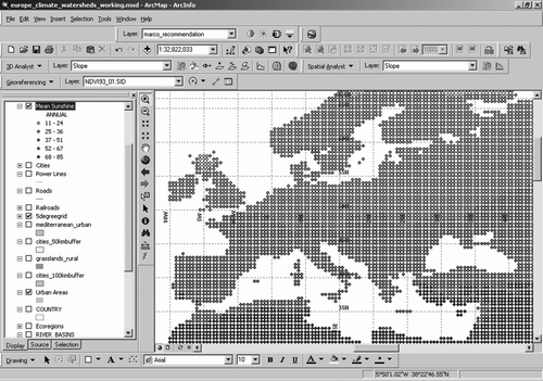
illustrates teaching about climate through a GIS, here showing mean annual sunshine, in percent, with the highest values in blue and the lowest in red. Here, sunshine data are stored as point data spaced evenly each half-degree of latitude and longitude using data from the USGS’ Global GIS project, distributed by the American Geological Institute. Through lessons built upon these data, students investigate the spatial relationship between sunshine and latitude, altitude, climate, population, and biomes.
Figure 1. Data from ‘Global GIS’ data set, Europe CD, compiled by USGS and sold by American Geological Institute, displayed in ArcGIS by ESRI, Inc., lesson created by Joseph Kerski. (Available in colour online).
Crossing the boundaries between teaching with GIS and teaching about GIS is the use of GIS as a fundamental research tool, in departments of geography, education, demography, geology, and in other departments and disciplines in higher education. People are attracted to GIS technology and methods whenever the ‘where’ question is important to a research problem. GIS is also used in education is as an administrative tool to manage campus infrastructure, including security, buildings, telecommunications, enrolment, recruiting, and the alumni network. Hence, GIS is becoming an increasingly useful tool to understand the Earth as a system.
Challenges of teaching with GIS
Challenges in teaching with GIS have delayed its full implementation in the primary, secondary, and university curricula, and delay the full use of GIS in teaching about the Earth. Today's main challenges lie not with hardware or software, but the structure of educational systems. With web-based GIS and free and low-cost school site license options, cost is often the least of the concerns. Technology is a ‘process; a systematic blend of people, materials, methods, and machines’ (Ely et al. Citation1992). GIS is by definition a system: It is both a technology and a set of methods. Integrating GIS into classroom practice is a complex process. Class periods are short, and the library of lessons that have been built for exploring Earth systems concepts using geotechnologies is growing but still limited.
GIS is also a challenging curriculum development platform. The educator is often confronted with a blank screen, and therefore must decide which data to use, then find, manipulate and present the data in a usable format. Next, the educator must decide what problem to solve and how to solve the problem with the tools included with the software. The educator must include some real world data and functions into the problem to simulate the real world, but not too many variables and data sets that would make it too complicated. In addition, educators often must design a lesson around these data and methods, and maintain that lesson through software upgrades and web site changes. Educators must match the software with instructional goals, subject matter, the students, and the context of instruction. The lack of exposure to GIS and spatial analysis while students are learning to become educators in university schools of education has also slowed implementation, because most instructors learn about GIS after they are already on the job (Boehm et al. Citation1994, Bednarz and Audet Citation1999). Guided inquiry entails changes in the technology, curriculum, social organisation and management of the classroom, teaching approach, and in basic beliefs about the nature of knowledge and the roles of teachers and learners (Powell Citation1999). Teaching with GIS involves unpredictable results and student-directed learning that many educators are not equipped to deal with (Audet and Paris Citation1997). Teaching with GIS may allow for deep learning, but may hinder educators from broad learning, covering every topic listed in each course's requirements.
A survey of 1520 secondary school teachers who own GIS software in the U.S. showed that student projects were community-based, fieldwork-based, interdisciplinary, and open-ended, involving ill-structured problems with real-world data (Kerski Citation2003). However, it also revealed that educators face the lack of training, lack of time in the curriculum, limited access to the computer laboratory, lack of software for certain operating systems, and the curricular ‘fit’ of GIS. Students and teachers may have confusion about the fundamental representational and spatial concepts upon which an understanding of GIS rests. This study and others (Alibrandi Citation2003, Baker and Case Citation2003) made it clear that geotechnologies in education must be used within the context of reform for long-term impact (Means Citation1994).
Ironically, although most content standards point to inquiry-based methods such as GIS, the current manner in which standards are being assessed is a serious hindrance to the use of these exploratory tools. Although standards themselves point to the use of tools such as GIS, most assessment instruments emphasise the memorisation of facts. Using GIS goes beyond facts, to examination of patterns, linkages, and trends, and therefore, students using GIS often do not score demonstrably higher on standardised tests (Kerski Citation2003).
Examples of teaching with GIS
Examples of students using GIS in the curriculum studying phenomena from the local to global scale abound. These examples show that using GIS together with GPS and Remote Sensing fosters a connection with the community through the acquisition of data and maps and through fieldwork. Using GIS, students have examined the Earth through three-dimensional analysis of a watershed, and by examining the Pacific ‘Ring of Fire’ using a map projection that shows all of the Pacific Ocean at once. Other students mapped animals struck by vehicles on a mountain pass and planned the location for a parking lot that would least impact the area next to a local wetland. Still others mapped human-set fires understand the geography of Africa by location and season of the year. Some students began to understand the pattern and causes of teen driving accidents in their local community in Maine using GIS. Others compiled a spatial database of trees by height, species, and condition on their school property that was adopted by their town council for the town's tree database. Other students use GIS to investigate the history and development of the African American community in their city. Students in Los Angeles map and analyse the ethnic makeup of neighbourhoods over time (Zanelli-English and Feaster Citation2003).
These developments are by no means confined to the USA. Students in Denmark investigate the reason for the location of wind farms and suggest additional suitable sites based on weather patterns, land use, and proximity to urban areas. Canadian Middle school students map alternative sites for a local urban landfill. New Zealand students investigate the distribution of gorse in their region and its relationship to the occurrence to wildfires. Costa Rican students mapped Nicaraguan refugees in their own region to understand how to help them and how to advocate their government to provide services to them (Kerski et al. Citation2006). Students in Turkey examine the relationship of climate to ecoregions (Ugurlu Citation2007). The SPLINT partnership in the UK (http://www.splint-cetl.ac.uk) is a Centre for Excellence in Teaching and Learning (CETL) led by the University of Leicester, the University of Nottingham, and University College London, focused on the pedagogy of geospatial technologies and the enhancement of spatial literacy in higher education (Chalkley Citation2006).
In using GIS, students learn about the Earth, its processes, its people, and how the world is changing from natural influences and from human-induced influences. They also gain skills that they will be able to use in the future as they become land use planners, epidemiologists, soil scientists, climatologists, cartographers, lawyers, wildlife biologists, geographers, economists, and other professionals. With the advent of web-based GIS, students use National Geographic's Map Machine to study the influence of altitude and latitude on climate, use the US National Atlas to analyse the spread of zebra mussels in the nation's rivers, and use the Geography Network's Arc Explorer Web to examine the interaction of biomes and land use. The advent of Virtual Globes such as ESRI's ArcGIS Explorer, NASA's World Wind, and Google Earth as viable teaching tools has brought 3-D visualisations to this map-rich educational environment and has spread geotechnologies to many educators who had not yet used them in any form.
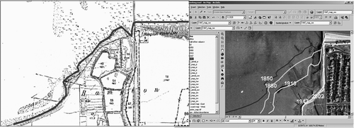
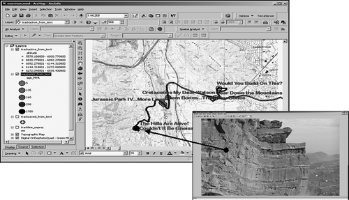
illustrates that Students in the UK learn about the degree of coastal erosion in Kent, in southeast England, by digitising the coastline as it appeared at several time periods through the last 150 years using digital maps and current aerial imagery. They measure the rates of erosion through time and consider the benefit and harm that shoreline construction of jetties and the placement of rock piles have had on the amount of erosion upcurrent and downcurrent from this location. Such studies can easily be placed into an Earth systems perspective, as coastal erosion and sea level rise are global problems.
Figure 2. GIS analysis shown in ArcGIS software from ESRI, data from UK Ordnance Survey for project created by Joseph Kerski for Kent coastal erosion lesson.
The international geospatial education community
After examining developments in GIS over the previous 25 years, Goodchild (Citation1992) claimed that GIS was no longer just a tool, but a way of thinking about problems from a spatial perspective with its own community – Geographic Information Science. In 2008, I argue that a similar, broad view be taken of the GIS education community. GIS is more than hardware, software, procedures, and spatial data. GIS is a network of people to network to solve technical problems. Technology may be socially constructed (Bijker et al. Citation1987, Pannabecker Citation1991), and the relevant social groups – those teaching with and about GIS – are a diverse but cohesive community committed to advancing GIS in education and society. I would argue that the education community that uses these tools in education has evolved to the point of being considered an International Geospatial Education Community. Community members include those who are in full-time education, consultancies, government, academia, educational associations, nonprofit organisations and private companies.
Characteristics of the international geospatial education community
Community, from two Latin words meaning ‘with gifts,’ suggests a sense of altruism, benefit, and learning from each other that comes from working together. Whether in the physical world, online (Goodfellow Citation2005), or in a combination of the two, a community is held together by some common identity or interests (Parse Citation2003) where members can learn from one another and make an impact on society. Communities help generate a shared language, ways of working, a collective memory, and shared experience. The geospatial education community embraces the four components of what Wenger (Citation1998) claims are necessary to characterise social participation as a process of learning and of knowing. These components include:
-
Meaning: A way of talking about our ability to experience our life and the world as meaningful;
-
Practice: A way of talking about the shared resources, frameworks, and perspectives that can sustain mutual engagement in action;
-
Community: A way of talking about the social configurations in which our enterprises are defined as worth pursuing and our participation is recognisable as competence;
-
Identity: A way of talking about how learning changes who we are and creates personal histories in the context of our community.
The community's mission is to promote spatial thinking and the spatial perspective through the use of geotechnologies in education and throughout societies around the world. First, similar to other educational communities (Kadel Citation2005), this community has struggled with the lack of research in this field and what its research agenda should be. Second, the community seeks to further research in the effectiveness and implementation of geospatial tools and methods in formal and informal education. Third, the community has very broad geographic and educational aims. It seeks to teach with geotechnologies in broader circles that encompass settings in formal and informal education, urban and rural environments, in an expanding array of disciplines, and in more effective ways, all over the world. Fourth, the community seeks to develop curricula to support teaching with geotechnologies. Fifth, the community continually seeks to communicate the message that increased use of geotechnologies and spatial thinking methods in education will result in more informed decisions at the local, regional, national, and international scales. These informed decisions will result in improvements in the quality of life for people and result in better health and sustainability for the planet.
Perhaps the community's characteristic that shows the most maturation is embodied by these active partnerships that move the agenda of the community forward. Continent-wide programs such as HERODOT (The Thematic Network for Geography Teaching and Training at http://www.zgis.at/herodotnet/), (Donert Citation2005) country-wide initiatives in Denmark (http://www.gogis.dk/) and New Zealand (http://www.gismaped.co.nz/), and statewide GIS initiatives in the USA are the result of successful partnerships among nonprofits, industry, higher education, schools, and government agencies. The My Community Our Earth (http://www.aag.org/sustainable) initiative through the Association of American Geographers encourages students around the world to examine community issues through geographic thinking and mapping tools (Solem et al. Citation2003).
Tenets shared by those who educate with GIS have been remarkably constant over the past two decades and are the beliefs around which the community has developed. One belief is that the goal of using geotechnologies is not to make the ‘perfect map,’ but to foster inquiry and analysis about the Earth and its people. Learning about the GIS tools is not the end goal, but rather, geotechnologies are the means to the end goal of an enhanced ability to think about problems from a spatial framework. Students are learning not just about natural hazards, energy, biomes, or population, but as they explore these rich data sets, they are rethinking their role in society. Many come to realise that they can connect with and have a decision-making role in their own community, region and world. They rethink their ideas about learning, realise that learning is a lifelong process, and therefore, that they must continually update their skills. They often rethink their own career path and place in society. They realise that information technologies can be applied to real-world problems, learn that the spatial perspective and maps are useful not only in geography but in dozens of other fields, and become aware of ways that their own career might be enhanced or changed by the acquisition of GIS skills. Most students are interested in looking at maps and satellite imagery of their own neighbourhood, and elsewhere in the world, and most students are interested in computer-based tools. GIS brings both of these interests to the forefront. Most students exhibit high interest in GIS as desktop software, on the web, and as a combination of the two using virtual globe software and streaming online data such as ArcGIS Explorer, NASA World Wind, Microsoft Virtual Earth, and Google Earth.
Because GIS is typically less complicated than computer games or other applications in which students regularly engage, students often require little technical instruction with GIS. Student enthusiasm lends itself to a high level of peer mentoring observed in many classrooms. The community holds that despite this interest and aptitude with GIS functions, the role of the instructor is still critical, for it is the instructor who frames the questions that engage higher order thinking skills and in a spatial context. This is good news for the instructor, because it frees him or her from having to be familiar with a large skill set in GIS functionality to doing what they do best, and what they love to do best: teach content. Therefore, the community acknowledges that while much geotechnology is not ‘plug and play,’ one does not have to be an expert to use it. The community encourages educators to actively network with the community not only for technical support, but for pedagogical support as they grapple with implementing spatial thinking and GIS in the classroom. In teaching with geotechnologies, they acknowledge that not everyone will learn the same thing, which may present a problem in terms of preparing students for standardised examinations but it is a philosophy that adheres closely to recommended models of teaching that acknowledge multiple intelligences. The community advocates careful consideration with regards to adopting any technology in education, and does not advocate the use of technology simply because it is used in the workplace. They do not advocate the conversion of existing lessons based on textbooks, paper maps, and atlases to digital format just for the sake of ‘doing it digitally.’ Rather, they advocate the use of technology if it helps educators accomplish their goals of enhanced learning of skills and content. Geotechnologies are not recommended to replace all existing lessons, but rather, as a carefully planned enhancement and a replacement for certain tasks. For example, students doing demographic analysis within a GIS environment can jump to the analysis stage much more quickly than students drawing census neighbourhood maps with coloured pencils. Earth systems scientists use a variety of other tools, such as statistical packages, and some argue that GIS is good at mapping and not as useful with certain kinds of analytics (such as 3D) and certain kinds of statistical displays. The appropriate tool should be used for the task at hand, whether in research or in education. The focus should change from ‘how do we ‘get’ geotechnologies into education?’ to ‘how can geotechnologies help me reach my instructional goals?’
The development of the international geospatial education community
Driving forces
The implementation of a new set of tools and methods in any educational environment is highly dependent on the interaction of people. The development of the international geospatial education community was dependent in part on technological and educational forces, but also on active community members who promoted its agenda. Because the manipulation of digital maps, grids, tables, and images are complex operations, the increase in computing power, memory, and storage space were key to the expansion of GIS in education just as they were key in its expansion in natural resources, planning, energy, and in other industries. Software that was more powerful and easier to use was a critically important innovation for educators who did not have the time to develop expertise in GIS. Two key software advancements were the change from command-line to menu-driven GIS software, followed by the GIS emulating standard Windows and Macintosh software interfaces and running on those same operating systems.
Because GIS is absolutely dependent on the availability and use of spatial data, the increasing availability of data sets at first from federal government agencies, followed by regional and local governments, nonprofit organisations, private industry, and higher education provided enormous utility to those using GIS. Coupled with the increased amount of data was the expansion of the means by which educators could access spatial information, through the web, geospatial portals, partnerships, and web mapping tools. Global low-resolution and increasingly, medium-resolution data have been becoming more widely available, downloadable, and ingestible into GIS software. This includes raster data sets such as satellite imagery, land cover, and digital elevation data, and vector point, line, and polygon data on ecoregions, transportation, population, and other themes. However, it is important for educators and students to at some point grapple with local data to analyse local issues. Local data include maps and aerial photographs that students can use as base maps for their GPS-collected field data to data on local land use, crime, or rivers. GIS use in education remains hampered in those countries where this local spatial data is either unavailable, is too expensive for educators to purchase, or has access restrictions. In some countries, visionary educators worked for several years on data and software agreements among private industry, public agencies, and schools (Jensen Citation2004), but the end result was data, software, and curricula available for student and educators.
Educational drivers that promoted the use of teaching with geotechnologies included instruction that adhered to the tenets of constructivism, that provided inquiry-driven, problem-based learning, and that assessed student work in an authentic way that emulated the workplace and whole learning. This was instruction that emphasised multidisciplinary education, team-based collaboration, peer mentoring, and that was focused on authentic projects. Good instruction was viewed as that which provided job skills and emphasised using real-world technologies, data, and contexts, as well as enhanced critical thinking, problem-solving, and decision-making skills (Alibrandi Citation2003). The educational standards movement across the world has served to advance the use of GIS in the classroom. While concerns have been voiced about the overemphasis on standardised tests that are based on rote memorisation that may stifle inquiry-based teaching methods and technologies such as GIS, most educational content standards and national curricula focus on the higher-order thinking skills such as analysis, synthesis, and evaluation over knowledge and comprehension.
Driving these efforts is an emphasis in educational content standards worldwide on using real-world data and methods to solve real-world problems (Schmoker and Marzano Citation1999). GIS relies on and fosters a mindset of exploration – it is the GIS user that makes the decisions, not the software. The student has to think about what he or she is displaying or modeling on the screen: no button or menu will solve that problem for them. GIS promotes finding information and knowing what to do with it. Geotechnologies provide instruments for implementing geographic thinking by employing the geographic inquiry process:.
shows how the geographic inquiry process meshes well with teaching about Earth systems through the use of GIS.
Figure 3. The geographic inquiry process meshes well with teaching about the Digital Earth through the use of GIS (from the book Mapping Our World, ESRI Press.)
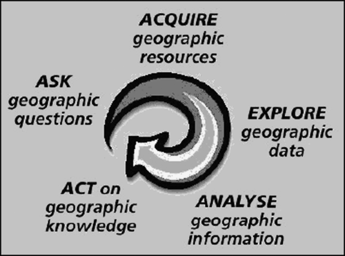
The geographic inquiry process often leads to a new question or multiple questions. GIS is a perfect tool to analyse the ‘what if…’ and ‘why’ questions. GIS allows for both context and content to be analysed – both location (where is it?) and place (what is it like?). The characteristics of place, whether they are watersheds, communities, neighbourhoods, or entire ecoregions, can be analysed not only in their correct location, but also in the context in which they occur on the Earth's surface. In this way, through modelling the complexities of the real world within a GIS, an understanding of the Earth is fostered.
Some educators around the world have been progressing toward a model of instruction that emphasises a hands-on, interdisciplinary, research-based learning experience. The US national geography standards state, ‘the power of a GIS is that it allows us to ask questions of data’ (Geography Education Standards Project Citation1994). Students using this inquiry-driven approach form research questions, develop a methodology, gather and analyse data, and draw conclusions. Teaching with GIS allows for authentic tasks and assessments, which, rather than multiple-choice and true-false examinations, emulate a portfolio and presentation that are given in the workplace. Teaching with GIS allows for team-based learning on problems that exist in the real world, rather than created for the classroom. Inquiry draws upon learning theory known as constructivism, which holds that rather than being transferred from teacher to student, knowledge is constructed by the learner based on his or her own experiences and making connections (Driver et al. Citation1994). Teaching with GIS is one practical way to use constructivism to help students understand their world. In a GIS, just as in lifelong learning, the process is even more important than the product.
illustrates how many educators have found that the use of analytical tools such as GIS helps nudge students toward the top of the pyramid envisioned in CitationBloom's (1956) taxonomy of six levels within the cognitive domain. Learners move from simple recalling or recognising facts at the base of the pyramid through increasingly more complex and abstract mental levels. Others are concerned that much use of GIS is targeted at the lower levels of the taxonomy (Milson Citation2005).
Figure 4. Bloom's taxonomy of six levels of the cognitive domain.
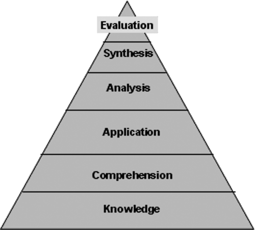
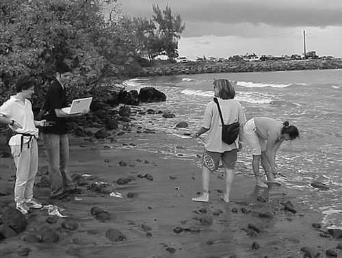
Figure 5. Collecting and analysing samples from the Pacific Ocean along with GPS coordinates, to compare water chemistry along the shore versus locations along freshwater streams. Photograph by Joseph Kerski, Kahului, Hawaii, during the Maui Digital Bus project institute supported by the My Community Our Earth initiative.
Another driving force behind using GIS in education has been continuing shortages of professionals who can use spatial analysis and geotechnologies, and resulting reports, grants, and programs that are aimed to reduce this shortage. The demand began in the natural resources fields, and spread to other scientific professions, such as biology, climatology, and epidemiology, and then spreading to non-science professions, including real estate, marketing, and journalism. Since 2000 a primary growth area in GIS careers has been in mobile and web applications. In the U.S., the Labor Secretary's Commission on Achieving Necessary Skills (SCANS) report stated that the most effective way to teach skills is ‘in context’ (U.S. Deptartment of Labor 1991). SCANS competencies include identifying resources, working with others, using information, and understanding complex and changing interrelationships. Implementing GIS into the curriculum emulates the same skills in which workers regularly engage, and may encourage learners to examine data from a variety of fields. In 2004, the US Secretary of Labor identified geotechnologies as one of the three most important evolving fields for the 21st Century. During the next year, the US CitationDepartment of Labor's High Growth Job Training Initiative allocated $1.6 billion for secondary, technical, and adult education programs, including $250 million for expanding community college GIS programs. The University Consortium of Geographic Information Science and the Association of American Geographers created the Body of Knowledge that describes key knowledge areas important in GIS education. The U.S. CitationNational Academy of Sciences report Learning to Think Spatially – GIS as a Support System in the K-12 Curriculum (2006) emphasised the value of spatial thinking in many disciplines, expressed disappointment that spatial analysis is lacking in the curriculum, and advocated that it be cultivated throughout the curriculum.
A longstanding concern accompanying teaching with technology is the ‘digital divide,’ referring to the persistent division between educational institutions that are well equipped with computer hardware and software and those that are not (Warschauer Citation2004). An advantage of spatial technologies is that they can be used in combination with low-tech and no-tech tools. These may include paper topographic maps, sketching on tablets, and home-made devices to measure tree height. In addition, increasing amounts of spatial analysis can be done entirely online using web-based GIS over standard web browsers. Moreover, some GIS software is free and can run on low-end machines.
Another force driving GIS in education is renewed interest in outdoor and experiential learning, coupled with alarm over what is perceived as an increasing disconnection between people and their environment. How can students learn about the Earth without going outside? How can people be expected to want to protect the environment if they have never had a field experience in education? Geotechnologies are not engaged only in the computer lab; they can be integrally related into fieldwork. The importance of equipping students with field experiences as frequently as possible and while the students are young has been well documented, perhaps most eloquently by Louv (Citation2005) in Last Child in the Woods (exemplified in figures). Using a combination of GPS, sketching, note taking, and probeware, students have investigated phenomena ranging from pH and dissolved oxygen in local streams, tree height and species, bird nests and animal dens, and weather and climate, and then analysed these field-collected data in a spatial context within a GIS and increasingly, with virtual globe software.
Geotechnologies are also considered to be an excellent bridge between schools and their communities, not just because the same technology is used by local governmental planners, but because the very issues that communities are grappling with can be investigated by students as well (CitationOrton Family Foundation 2003). Educators often value geotechnologies as part of essential citizenship education. Students who study local issues while still in primary and secondary school may be more active in their community as adults and are better poised to conduct research at university level (Kerski Citation2004b).
Public awareness of environmental issues and engagement in geotechnologies
Public awareness of environmental issues may also be at an all-time high. Many people seem to sense that these are complex problems, that they need to be solved, and will not be solved unless we are regularly engaging students and researchers in the discussions. EnviroSchools in New Zealand began with ecology-minded students who are linking up with national and international organisations to promote sustainable practices and also to inject more environmental education in the school system (Law Citation2005). The Project on Public Spaces and Urban Atmospheres is dedicated to helping people create and sustain public places that build communities. GeoOptics, founded by scientists, seeks to establish a new model of community-based space and development for the public good. The International Society for Ecology and Culture is concerned with the protection of biological and cultural diversity, while the Global Mind Shift highlights the need to solve global and interconnected world problems for the long term.
Most of the public has not made the connection between grappling with global issues and the applicability of geotechnologies in education. Most have not considered that the discipline of geography regularly grapples with these environmental and social issues. However, increased awareness is encouraging many educators to increasingly include these issues in classroom instruction. At the same time, the advent of digital maps for directions, travel, and exploration via computer, cell phone, PDA, and in vehicles, is helping general public, educators, and students to become increasingly spatially aware, and familiar with geotechnologies. They are seeing daily media coverage as well as witnessing local events that illustrate the interconnection of people and the planet, and are experiencing more frequent and jarring reminders that the pervasive problems of our world need a holistic and geographic approach to solving them. The first step in CitationRogers’ (1995) diffusion of innovation – awareness – has been largely met through societal inundation by the plethora of geotechnologies.
Geotechnologies in education benefit from the convergence of geotagged imagery and web-based mapping. Since the advent of digital photography, it has been possible to retrieve images based on when they were taken and the content of those images. Geotagging allows photographs to be referenced based on where they were taken, either with software that adds latitude-longitude positions from a GPS to the photo files or else a special camera with a GPS attached. The photograph's time is matched to the time that the GPS coordinates were taken, attaching a latitude-longitude position to the photograph's header information. Each month, people are linking three million images to maps using one tool (Flickr) alone. HoudahGeo, GPSPhotoLinker, and other tools make it easy to add locations to photographs, but increasingly, to movies, text, and sound (). Map-based stories that are facilitated by web-based GIS are becoming more commonplace online. Following the trail of Lewis and Clark, the Underground Railroad, or the Silk Road are only a few examples of the emerging media-rich, map-based, geotagged internet.
Figure 6. Ground photograph hyperlinked to geologic field data after field data and GPS coordinates have been uploaded into the GIS. Hyperlinked data to field locations are increasingly in the form of video, audio, animations, and text, in addition to standard photographs. GIS analysis shown in ArcGIS software from ESRI, field study geologic exercise in Colorado USA by Joseph Kerski.
At the same time, Earth systems studies increasingly relies on sources outside of traditional national mapping agencies, including geotagged entries created by such diverse groups as chambers of commerce, environmental organisations, and the general public. One example is the over 2500 photographs contributed for Uluru (Ayers Rock, Australia) alone (Goodchild Citation2007). This is ‘citizen science,’ communities or networks of citizens who act as observers in some domain of science. It is a part of ‘volunteered geographic information’ that helps people learn about local activities in geographic locations that ‘go unnoticed by the world's media, and about life at a local level.’ Because these data usually do not adhere to any established accuracy or content standards, they can pose a challenge in teaching and learning with geotechnologies for students who regard any digital map as ‘perfect.’ However, accessing volunteered geographic information can be used as a teaching tool to illustrate the need for mapping standards and the need for metadata, forcing students to develop a critical stance on data so that they must evaluate the pros and cons of using it in their own project.
Advancements in curriculum and research
Despite all of the aforementioned advancements, GIS would have remained small in education without simultaneous advancements in curriculum and support for teachers. The growing body of curricula teaches problem solving, focusing on the ‘whys of where’ – geographic inquiry. Curricula began with lessons that individual teachers created in the classroom, then extended to lessons and assessments in books such as Mapping Our World (Malone et al. Citation2002) and Community Geography (Zanelli-English and Feaster Citation2003), Internet-based libraries such as ArcLessons (http://www.esri.com/arclessons) and national efforts such as New Zealand's active GIS education community (Olsen Citation2002) and Denmark country-wide GIS in education program (Jensen Citation2004), to international initiatives such as the geotechnology focus in Europe's geography network in higher education, HERODOT (Donert Citation2005).
Research efforts in GIS in education are gaining strength in numbers and effectiveness. Because GIS is not a standalone subject in most primary and secondary schools, school officials need to be convinced of its value and its curricular fit. Officials often also require evidence from sound educational research in order to justify their support for teachers in their districts who advocate its use. Early GIS research focused largely on describing efforts of individual educators who had a success story to tell about their use of GIS in an individual classroom. While case studies have value, more recent research examines students’ attitudes and achievement (Baker and Case Citation2003), and the implementation and effectiveness of GIS at a national level in specific countries such as Denmark and the Netherlands (Jensen Citation2003), the USA (Kerski Citation2003), and Turkey (Ugurlu Citation2007).
Other forces not mentioned here have also fostered the creation of the international geospatial education community. At the same time, challenges continue to limit the community's effectiveness and indeed, the implementation of geotechnologies in education. The community has an enormous task ahead, but the progress thus far and the increasing seriousness of global geographic issues will likely encourage the community to press on toward its goals.
Recommendations
There are many ways to foster spatial literacy among students at all levels and ages. Geotechnologies are not the only way, but provide a key means of achieving spatial literacy goals. One must keep in mind that the goal of using GIS over paper maps and atlases is not to make ‘prettier’ maps, ‘final’ maps, or the ‘perfect’ map. The objective in using GIS is to analyse the Earth and its people. CitationPiaget's words (1929) in The Child's Conception of the World are particularly appropriate to teaching with geotechnologies: ‘The trouble with education…is that the best teaching methods are in fact the most difficult.’ Students will find them engaging and will have little trouble with the software. However, the role of the instructor is critical, for it is the instructor that frames the inquiry-based questions. The instructor makes the difference between a spatial investigation and a random browse through maps.
As problems in the 21st century become more serious, grow in geographic extent, and affect individuals’ everyday lives, they still have one thing in common: they are all geographic issues. Education that invites students to analyse things spatially using GIS is an essential skill that must be used if we hope to grapple with these issues. What matters is not whether we are using geotechnologies in education, per se. What matters is if students are asking questions about their world, and critically analysing data. Geotechnologies are some of the best means to accomplish that.
As the ‘where’ question drives more everyday decisions in government, academia, nonprofits, and business, the impact of the Digital Earth in everyday decision-making and in education is huge. Investigating the Earth through geotechnologies enables and encourages students to investigate everything from protecting tropical rainforest in Africa to mitigating coastal erosion in England. This represents a partial realisation of R. Buckminster Fuller's original Digital Earth vision – global access to all possible geographic data through visualisation systems with user-friendly interfaces to achieve a sustainable Earth.
GIS is not a panacea for all that is difficult or complex to teach. Limitations and cautions exist with using any technology. Students need to understand that not everything on the computer is complete and accurate. Moreover, they need to understand that maps, just because they are in digital form and are richer in content than ever before, are not perfect. Students need to understand that all computer data has limitations, omissions, and distortions, particularly maps, which are inherently just models of reality. Most importantly, they need to be aware of what is missing from maps, and compile and understand layers of information so that the phenomenon under study is able to be modeled and understood. David Orr (Citation1994) wrote, ‘Now more than ever, we need people who think broadly and who understand systems, connections, patterns, and root causes…how to think in whole systems, how to find connections, how to ask big questions, and how to separate the trivial from the important.’ That is precisely what some educators believe that the use of GIS fosters.
Conclusion
Our Earth is not only being mapped to a finer level of detail than ever before, but it is also being mapped with new content that was absent from maps of the past – crime hotspots, erosion rates, fertiliser applications, invasive weeds, tsunami heights, river sedimentation rates, migration rates, and species indices. This content no longer represents only static phenomena, but includes phenomena that are changing, including wildfires, disease outbreaks, tracks of individual land and marine animals, to street level views from mobile cameras. This map content may be explored in two dimensions, obliquely, and in three dimensions. Educators and students are discovering layer upon layer of information no longer just with desktop GIS, but also via web-based GIS to examine a location's schools, history, lodging, weather, environmental conditions, voting record, and recent events. Webcams and sensors increasingly monitor the world, providing data for geographic information systems and the people who use them. ESRI President Jack Dangermond draws an analogy between the body's nervous system that provides signals to the brain and the GeoWeb as a ‘nervous system for the planet,’ helping us make wise decisions about its finite natural resources (Dangermond Citation2004). To teach about our world, GIS education and the Digital Earth are a logical pairing.
The geotechnology education community predates the Digital Earth community, but they are both international in scope, share similar goals of conservation and sustainability, and include members with similar backgrounds in science, computer science, and GIS. The Digital Earth community's direct role in the advancement of geotechnologies in education is still small. This may be in part owing to the fact that while the Digital Earth community shares some goals with the geotechnology education community, the two communities have grown up separately. Goodchild (Citation2008) recognised that while GIS and Digital Earth technologies might converge in the future, and indeed, already share some common elements, they are distinct. This distinction lends a richness to both communities, but to promote educational change, the two communities might wish to formulate a set of common education goals. Digital Earth is an ideal framework for contextualising domains of inquiry. The Digital Earth community, especially via the International Society for Digital Earth and its activities, can have a significant impact on the growth of geotechnologies in education. Moreover, the Digital Earth community can have an impact on what gets taught, where it gets taught, and how it gets taught at all levels of education around the world. Through education, this effort can foster the forward movement of the Digital Earth.
Notes on contributors
Joseph Kerski serves as Education Manager for Environmental Systems Research Institute (ESRI) in Colorado, USA. He served for 21 years as Geographer at the US Geological Survey and at the US Census Bureau. He has taught as Adjunct Instructor of GIS in traditional and online settings at Sinte Gleska University on the Rosebud Sioux Reservation and at other universities. Joseph holds three degrees in Geography. He seeks and fosters educational partnerships, creates curricular materials focused on spatial thinking and geotechnologies in education, conducts research in the effectiveness and implementation of these technologies in education, and teaches classes and workshops in geotechnologies and in spatial thinking. Joseph believes that spatial thinking and the use of geotechnologies is critical to our future.
Related Research Data
References
- Alibrandi , M. 2003 . GIS in the classroom: Using geographic information systems in social studies and environmental science , Portsmouth, NH : Heinemann .
- Anker , P. 2007 . Buckminster Fuller as captain of spaceship Earth . Minerva , 45 ( 4 ) : 417 – 434 .
- Audet , R.H. and Paris , J. 1997 . GIS implementation model for schools: Assessing the critical concerns . Journal of Geography , 96 ( 6 ) : 293 – 300 .
- Baker , T. and Case , S. 2003 . The effects of GIS on students’ attitudes, self-efficacy, and achievement in middle school science classrooms . Journal of Geography , 102 ( 6 ) : 243 – 254 .
- Bednarz , S.W. and Bednarz , R.S. , 2008 . The effect of explicit instruction in spatial thinking . In : A. Demirci , M. Karakuyu , M. A. McAdams , S. Incekara & A. Karaburun Proceedings of the 5th International Conference on GIS (ICGIS) ., Istanbul, Turkey , Vol. 2 , 649 – 656
- Bednarz , S.W. and Audet , R.H. 1999 . The status of GIS technology in teacher preparation programs . Journal of Geography , 98 ( 2 ) : 60 – 67 .
- Bijker , W. , Hughes , T. and Pinch , T. 1987 . The social construction of technological systems , Cambridge, MA : MIT Press .
- Bloom , B. 1956 . Taxonomy of educational objectives, handbook 1 , New York : Longman .
- Boehm , R.G. , Brierley , J. and Sharma , M. 1994 . “ The Bete Noire of geographic education: Teacher training programs ” . In A decade of reform in geographic education: inventory and prospect , Edited by: Bednarz , R.S. and Petersen , J.F. 89 – 98 . Indiana, PA, USA : National Council for Geographic Education .
- Chalkley , B. 2006 . Tertiary teaching excellence: The CETLs scheme in England . New Zealand Geographer , 62 ( 2 ) : 155 – 157 .
- Dangermond , J. , 2004 . Plenary presentation . 2004 ESRI International User Conference . San Diego, CA .
- Donert , K. 2005 . Higher Education GIS in Geography: a European Perspective , Liverpool, , UK : Liverpool Hope University .
- Driver , R. 1994 . Constructing scientific knowledge in the classroom . Educational Researcher , 23 : 5 – 12 .
- Ely , D.P. 1992 . “ Trends in educational technology 1991 ” . In Educational Media and Technology Yearbook 1992 , Edited by: Ely , D.P. 1 – 29 . Englewood, CO, USA : Libraries Unlimited .
- Fuller , R.B. 1963 . Operating manual for Spaceship Earth , Baden, , Switzerland : Lars Müller Publishers .
- Geography Education Standards Project . 1994 . Geography for life: national geography standards . Washington, D.C , National Geographic Society .
- Golledge , R. , Marsh , M. and Battersby , S. 2008 . A conceptual framework for facilitating geospatial thinking . Annals of the Association of American Geographers , 98 ( 2 ) : 285 – 308 .
- Goodchild , M. 2008 . The use cases of digital earth . International Journal of Digital Earth , 1 ( 1 ) : 31 – 42 .
- Goodchild , M. 2007 . Citizens as sensors: The world of volunteered geography. Paper for conference on Volunteered Geographic Information , 13 – 14 December 2007 . Available from: http://www.ncgia.ucsb.edu/projects/vgi/docs/position/Goodchild_VGI2007.pdf [Accessed 30 June 2008].
- Goodchild , M. 1992 . Geographic information science . International Journal of Geographical Information Systems , 6 ( 1 ) : 31 – 46 .
- Goodfellow , R. 2005 . Virtuality and the shaping of educational communities. Education . Communications and Information , 5 ( 2 ) : 113 – 129 .
- Jensen , T. , 2003 . From geo-data to geo-knowledge . Thesis (Masters). University of Aalborg, The Netherlands .
- Jensen , T. 2004 . GIS in environmental and wind energy in Danish high schools . Proceedings of the 2004 ESRI Education User Conference . San Diego , California . Available from: http://gis.esri.com/library/userconf/educ04/papers/abstracts/a5152.html [Accessed 30 June 2008].
- Johnson , D.R. , Ruzek , M. and Kalb , M. , 1998 . National and international Earth Systems Science Education partnerships: Approaching the new millennium . In Proceedings of the 1998 International Geoscience and Remote Sensing Symposium , Seattle, WA, USA, July .
- Kadel , R. 2005 . Putting the pieces together: Exploring the idea and purpose of developing a research agenda for educational technology . Learning and Leading With Technology , 32 ( 8 ) : 28 – 29 .
- Kemp , K. , et al. , 2008 . Ha'ahonua: Using GIScience to link Hawaiian and Western knowledge about the environment . In : A. Demirci , M. Karakuyu , M.A. McAdams , S. Incekara and A. Karaburun Proceedings of the 5th International Conference on GIS (ICGIS) , Istanbul, Turkey , Vol. 1 , 413 – 418
- Kerski , J. 2008 . “ The world at the student's fingertips: Internet-based GIS education opportunities ” . In Digital Geography , Edited by: Milson , A. and Alibrandi , M. 119 – 134 . Charlotte, NC : Information Age Publishing .
- Kerski , J. , 2006 . Earth visions: GIS in Indian country . Winds of Change . American Indian Science and Engineering Society , 21 ( 3 ). Summer.
- Kerski , J. , Palmer , R. and Palmer , A. 2006 . Jungle classroom: Geotechnology boosts education in Costa Rica's lowland rainforest . GeoWorld , 18 ( 7 ) : 42 – 44 .
- Kerski , J. 2004a . The global GIS project: Spatial analysis for the world . Interaction 32 (3). Victoria, , Australia : Geography Teachers Association of Victoria .
- Kerski , J. , 2004b . GIS for citizenship education . In A. Kent and A. Powell Geography and citizenship education: research perspectives . Published for the International Geographical Union Committee on Geographic Education by the University of London Institute of Education .
- Kerski , J. 2003 . The implementation and effectiveness of GIS technology and methods in secondary education . Journal of Geography , 102 ( 3 ) : 128 – 137 .
- Law , B. 2005 . Education for sustainable development in New Zealand . Applied Environmental Education and Communication , 4 ( 3 ) : 277 – 281 .
- Libarkin , J. and Kurdziel , J. 2006 . Ontology and the teaching of Earth system science . Journal of Geoscience Education , 54 ( 3 ) : 408 – 413 .
- Louv , R. 2005 . Last child in the woods: Saving our children from nature-deficit disorder , Chapel Hill, NC : Algonquin Books .
- Malone , L. , Palmer , A. and Voigt , C. 2002 . Mapping our world: GIS lessons for educators , Redlands, CA : ESRI Press .
- Means , B. 1994 . Technology and education reform: The reality behind the promise . San Francisco, CA : Jossey-Bass .
- Merryfield , M. , Jarchow , E. and Pickert , S. 1997 . Preparing teachers to teach global perspectives . Thousand Oaks, CA : Corwin Press .
- Milson , A. 2005 . GIS in K-12: Pedagogical tool or weapon of mass distraction? . Research in Geographic Education , 7 : 62 – 73 .
- National Academy of Sciences , 2006 . Learning to think spatially–GIS as a support system in the K-12 curriculum . Washington, DC : The National Academies Press , 313 p.
- Nicol , R. 2003 . Outdoor education: Research topic or universal value? . Journal of Adventure Education and Outdoor Learning , 3 ( 1 ) : 11 – 27 .
- Olsen , A. 2002 . Using GIS software in school teaching programmes: An initial survey . New Zealand Journal of Geography , 113 ( 1 ) : 17 – 19 .
- Orr , D. 1994 . Earth in mind: On education, environment, and the human prospect , Washington, DC : Island Press .
- Orton Family Foundation, . 2003 . Making community connections: The Orton family foundation community mapping program , Redlands, CA : ESRI Press .
- Pannabecker , J. 1991 . Technological impacts and determinism in technology education: Alternate metaphors from social constructivism . Journal of Technology Education 3 ( 1 ). Fall.
- Parse , R. 2003 . Community: A human becoming perspective , Boston : Jones and Bartlett Publishers .
- Phoenix , M. 2004 . Global GIS education . Geomatics Information Magazine , 34 – 37 .
- Piaget , J. 1929 . A child's conception of the world , Lanham, MD : Littlefield Adams Publishing .
- Powell , J.C. 1999 . The relationship between teachers’ beliefs and the use of reform-oriented science curriculum materials , Thesis (PhD). University of Colorado, Boulder .
- Rogers , E. 1995 . The diffusion of innovations. 4th ed , New York : Free Press, 519 p .
- Schmoker , M. and Marzano , R. J. 1999 . Realizing the promise of standards-based education . Educational Leadership , 56 ( 6 ) : 17 – 21 .
- Schultz , R.B. , Kerski , J. and Patterson , T. 2008 . The use of virtual globes as a spatial teaching tool with suggestions for metadata standards . Journal of Geography , 107 ( 1 ) : 27 – 34 .
- Solem , M. 2003 . Using the Internet to support international collaborations for global geography education . Journal of Geography in Higher Education , 27 ( 3 ) : 239 – 253 .
- Sui , D. 1995 . A pedagogic framework to link GIS to the intellectual core of geography . Journal of Geography , 94 ( 6 ) : 578 – 591 .
- Ugurlu , N. 2007 . The effects on student attitude and achievement to teaching of GIS supported subject of Turkey's natural resources in social studies courses , Thesis (PhD). Gazi University, Ankara .
- U.S. Department of Labor ., 1991 . Secretary's Commission on Achieving Necessary Skills (SCANS)
- Warschauer , M. 2004 . Technology and social inclusion: rethinking the digital divide , Cambridge, MA : The MIT Press .
- Wenger , E. 1998 . Communities of practice: Learning, meaning, and identity , Cambridge, , UK : Cambridge University Press .
- Xu , G.H. and Chen , Y.T. 1999 . Towards Digital Earth . Proceedings of the International Symposium on Digital Earth, Vol. I . 30 November–2 December 1999. Beijing, , China : Science Press .
- Zanelli-English , K. and Feaster , L. 2003 . Community geography: GIS in Action , Redlands, CA : ESRI Press .