Abstract
This paper presents a technique for the assessment and mapping of land biodiversity by using remote sensing data. The proposed approach uses a fuzzy model that encapsulates different ecological factors influencing biodiversity. We implemented our approach as a web service for the Pre-Black Sea region of the Ukraine.
1. Introduction
Biodiversity is often considered as a variety of species in a given region or area (Turner et al. Citation2003). Its assessment is important for analysis of ecological state and for scientifically proved administrative decision making.
As a rule biodiversity research is carried out by field methods and measurements. The use of remote sensing data for biodiversity assessment makes it possible to extend the research areas and obtain reliable information on vegetation spatial distribution (Jensen Citation2000).
However, direct assessment and mapping of biodiversity including all biological components is a complex task. Therefore, we propose to use an ecosystem approach for biodiversity assessment. It is based on close interrelations between the living and non-living elements of the environment in the context of different levels of ecosystems. Hence, by determining the elements that can be derived from remote sensing data, it becomes possible to predict potential biodiversity, in other words, species diversity that is typical for a given area according to its environmental conditions.
The Pre-Black Sea region of the Ukraine along with the Crimean peninsula has unique natural resources and life forms. The Crimea peninsula is a unique region in Ukraine, and one of eight in Europe that have been included in the list of regions with a high level of biodiversity. This region requires special attention in order to prevent biodiversity losses and to put its conservation into practice. This is the reason why estimation and monitoring of biodiversity in this region is a task of great importance both for the Ukraine and the worldwide community.
Many Ukrainian organisations participate in the development of Ukrainian segment of Global Earth Observation System of Systems (GEOSS) – GEO-UA. The important task for the Ukraine in the context of participation in Group on Earth Observations (GEO) activities is a development of corresponding information infrastructure. This infrastructure should integrate capabilities of different organisations working in the area of Earth observations and provide information services for accessing Earth observation data and derived products.
This paper focuses on a scientific and technologicaly approach to biodiversity assessment and mapping in the Pre-Black Sea region using multispectral space imagery and other remote sensing data. The proposed approach is implemented in the form of WMS-compliant web service (OGC's WMS Citation2008) that is accessible via the Internet. The results of implementation of the service in GEOSS Architecture Implementation Pilot are also discussed in the paper.
2. Methods
2.1 Factors
Biodiversity is associated with a number of abiotic and biological factors that can be identified using remote sensing data. These factors include: landscape types, geographical latitude/altitude, climate conditions (such as mean daily temperatures, humidity), structure and primary productivity of a vegetation mantle (Hansen and Rotella Citation1999).
The factors that influence rates, forms and orientation of biota differentiation are well known. That leads us to the tasks of estimation of these factors using remote sensing data and determination of possible values range for biodiversity assessment (Stankevich and Kozlova Citation2007a, Citationb).
Several primary factors that influence biodiversity and can be estimated using remote sensing data have been chosen for the research. They are presented in .
Table 1. Factors influencing land biodiversity.
2.2 Data
Factors from can be estimated by using low, medium and high spatial resolution calibrated multispectral space imagery. It can be done using standard algorithms for processing of multispectral sensors data. Some of them are open and free. For example, such algorithms have been developed, verified and embedded into standard software for satellite imagery processing (Lillesand et al. Citation2004) for the flowing satellite sensors: EOS/MODIS, Envisat/MERIS (low spatial resolution) and Landsat/ETM+, EOS/ASTER (medium spatial resolution).
Depending on specifics the one of widespread and consistent land cover classification systems of global (IGBP Land Cover, UMD Land Cover, Global Land Cover 2000) or regional level (CLC 2000, GSE-Land, PELCOME) can be used. The full set of the task, a the data products for biodiversity assessment is provided by the Earth Observation System (EOS) international scientific project for free (Parkinson and Greenstone Citation2004).
The Digital Terrain Elevations Data (DTED) is required for Surface Solar Irradiation evaluation and more accurate landscape-ecosystem classification of research area. In this work we use the global DTED Shuttle Radar Terrain Mission 90 m resolution (SRTM3) v2.0 which is available for free (Rodriguez et al. Citation2005).
For biodiversity assessment the remote sensing data should be integrated during a growing season when exact classification of a vegetation mantle is possible.
2.3 Model
Correct evaluation of factors influencing biodiversity requires establishment of the deterministic or statistical dependences between them. In the first (deterministic) case cause-effect ecosystem models of high spatial resolution for each landscape part should be developed. High complexity and weak elaboration of such models can negatively affect the accuracy of final results. Using remote sensing data can substantively improve parameters of the models or type and composition of equations. In the second (statistical) case the significant amount of ground truth data is required for making regression. It leads to excessive increasing of field researches. Both approaches have their own advantages and drawbacks, and both of them can be improved by using remote sensing data. Fuzzy-logic approach is a compromise. Fuzzy models allow one to describe the determined interrelations with uncertain parameters and statistical dependences with unknown distribution laws, and to formalise expert knowledge about processes in studied ecosystems. Another advantage of a fuzzy-logic model is weak response of fuzzy operations to a kind of subjectively approximated membership functions in a broad range of fuzzy values (Klir et al. Citation1997).
Lets denote quantitative values of factors that influence biodiversity assessment B as F i , i=1..n, where n – total number of factors. For each of m classes of land cover it is possible to define species richness B 0 (j) , j=1..m, obtained from biological species count of a given class N 0 (j). It can be described by the following formula:
Each factor gets fuzzy membership function µ i (F i ) on the basis of environment models, statistical dependences or expert knowledge. These membership functions indicate how much some factor F i influences biodiversity. If all membership functions are defined, it is possible to calculate the joint membership function µ 0 of all factors.
In our case fuzzy conjunction will be a natural operation for joint membership function µ 0 :
After calculation of joint membership function (2) and potential biodiversity indicator (1) potential biodiversity index B could be assessed:
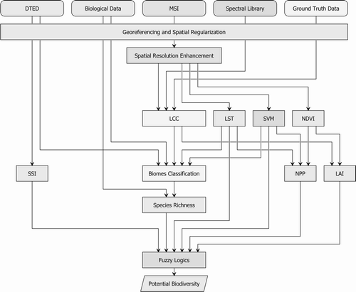
The diagram for biodiversity assessment represents dataflow within the fuzzy-logic model using remote sensing data (Stankevich and Kozlova Citation2006) and is shown in . All necessary remote sensing and ground-truth data should be previously georeferenced and spatially regularized. Also, classification improvement requires implementation of spatial resolution enhancement procedure. Quantitative values of the selected factors (namely LCC, LST, SVM, NDVI, NPP, LAI, SSI) are calculated using known algorithms (Baccini Citation2007; MODIS Land Algorithm User's Guide Citation2003). Biomes classification is based on land cover classification and detailed by land surface temperature, soil/vegetation moisture and terrestrial elevation. It makes it possible to define species richness of each biome class using respective biological data. After that, further assessment of potential biodiversity using the fuzzy-logic model is feasible.
Figure 1. Biodiversity assessment model diagram
3. Results
In the framework of the innovative project National Academy of Sciences of Ukraine, experts from the Scientific Centre for Aerospace Research of the Earth (CASRE) and the Space Research Institute NASU-NSAU (SRI) have developed a web service for biodiversity assessment for the Pre-Black Sea region of the Ukraine using EOS data products. It provides the potential biodiversity index mapping over the region as output of EOS data products processing according to the biodiversity assessment model diagram (.)
The workflow for biodiversity estimation consists of the following three steps: data acquisition, data processing, and visualisation. shows the overall architecture of the service with information flows.
Figure 2. Overall architecture of the proposed service with information flows
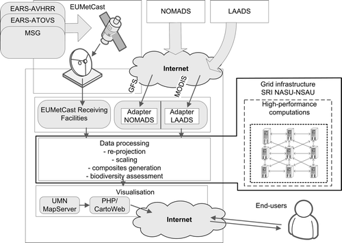
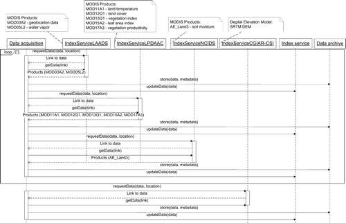
A special system was developed in order to receive satellite data on a regular basis. This system provides checking for the new products, automatic data acquisition from different sources (in particular, from Level 1 and Atmosphere Archive and Distribution System (LAADS), Land Processes Distributed Active Archive Center (LP DAAC) and National Snow and Ice Data Center (NSIDC)), storing data in the archive of SRI, and metadata index updating. The detailed UML sequence diagram (Larman Citation2004) for the data acquisition step is shown in .
Figure 3. UML sequence diagram for the data acquisition step of the biodiversity assessment procedure
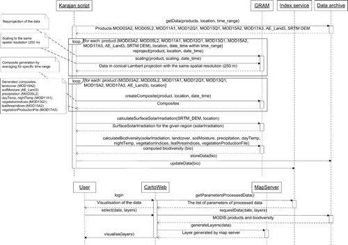
After the required data has been acquired, re-projection to the same projection (in this case we used a conical Albert projection) and scaling to the same spatial resolution (250 m) is performed. Since we use data from multiple sources different tools were applied for the re-projection and scaling. In particular, we used MODIS Swath Reprojection Tool, MODIS Reprojection Tool, and GDAL (Geospatial Data Abstraction Layer, http://www.gdal.org). Since biodiversity index represents a parameter that is estimated for some period of time it is required to calculate average values for the parameters influencing biodiversity. For this purpose, average composites of images were created. Using these composites and solar irradiation acquired from SRTM we estimated biodiversity index using fuzzy model according to Equations (Equation1)-(Equation3). The resulting product is a georeferenced file in GeoTIFF format with biodiversity index over the given region. The workflow of the data processing step is controlled by the Karajan engine (http://www.gridworkflow.org/snips/gridworkflow/space/Karajan) while the data are processed on the computational resources of the Grid system (Kussul et al. Citation2008) with the use of the Grid Resource Allocation and Management (GRAM) service (Feller et al. Citation2007). The detailed UML sequence diagram for the data processing and visualisation steps is shown in .
Figure 4. UML sequence diagram for the data processing and visualisation steps of the biodiversity assessment procedure
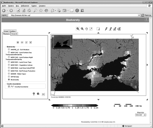
The proposed web service is implemented on the basis of open standards and GEOSS development principles using the open software, in particular UMN MapServer (http://mapserver.gis.umn.edu/) and Cartoweb (http://www.cartoweb.org/). Biodiversity monitoring service implements standard OpenGIS Web Map Service 1.1.1 (http://www.opengeospatial.org/standards/wms">http://www.opengeospatial.org/standards/wms) and web Coverage Service 1.0 (http://www.opengeospatial.org/standard) interface. The developed Web service is accessible via the internet through the address http://biodiv.ikd.kiev.ua (). It represents a current distribution of potential biodiversity and allows inspect of each of the factors considered during its assessment.
Figure 5. Demonstration of web service for biodiversity assessment using EOS data products for Pre-Black Sea region of the Ukraine
4. Conclusions
In this paper we described the approach for land biodiversity assessment and mapping using Earth observations data. The proposed approach was developed for the Pre-Black Sea region, but, in general, can be extended to any other region. The developed Web service for biodiversity monitoring enables regular and operational acquisition of biodiversity estimates in the Pre-Black Sea region and allows one to track changes in its values. This, in turn, reveals negative changes in the environment of the given region and provides adequate information about biodiversity hot-spots.
It is supposed that the developed webservice becomes the Ukrainian part of the international geoportal created within the European Biodiversity Observation Network (EBONE) program. The purpose of this program is observation and data distribution system development for biodiversity monitoring at regional, national and European levels. This system is developed under the GEO Work Plan 2009-2011, which is supported by the European Union. In the future, the EBONE will be integrated to the Global Earth Observation System of Systems (GEOSS).
Future works will be directed to the use of medium and high-resolution satellite data in order to improve the quality of the proposed service. This will be done by using Landsat/ETM+ and ASTER data, as well as SAR (Synthetic Aperture Radar) and modelling data for the soil moisture estimation. Other actions will be directed to analysis of long-term time-series of biodiversity index in order to reveal and predict changes in ecosystem of the given region.
Notes on contributors
Mikhail A. Popov is the Scientific Center for Aerospace Research of the Earth (CASRE) Deputy Director. He received his PhD degree in Engineering from the Kiev Air Force Academy in 1973 and his DrSci in Engineering from the same Academy in 1994. He has been a Professor since 1995. In 2000 he was promoted to the Honored Scientist of Ukraine. He became the CASRE Deputy Director in 2002. In 2005 he received the State Prize of Ukraine in Engineering. He is the author of more than 220 scientific papers, 17 books and 48 patents. His current research interest is the new methods and technologies development for remote sensing.
Nataliia N. Kussul is Head of the Department of Space Information Technologies and Systems at the Space Research Institute of NASU-NSAU, Professor at the National Technical University of Ukraine “Kiev Polytechnic Institute”, and Chair of the Branch of Software Engineering Department in the National Aviation University. She received Doctor of Sciences (second scientific degree) in Applied Mathematics from the Space Research Institute of NASU-NSAU in 2001, Ph.D. degree in Applied Mathematics from the Institute of Cybernetics of NASU in 1991, M.S. degree with honors in Mathematics from Kiev State University in 1987. She is a Vice Chair of Technology and Services Subgroup of the CEOS Working Group on Information Systems and Services (WGISS). Professor Kussul's current research interests include the development of complex distributed systems, Grid technologies, Sensor Web, intelligent methods of data processing, neural networks, pattern recognition, multi-agent systems, remote sensing image processing. She is the author of more than 200 journal and conference papers and five books in these areas.
Sergey A. Stankevich is the Scientific Center for Aerospace Research of the Earth (CASRE) Leading Researcher. He received his PhD degree in Engineering from Kiev Air Force Academy in 1994. He has been a Senior Lecturer since 1995. He became the CASRE Leading Researcher in 2004. He is the author of some 120 scientific papers, two books and eight patents. His current research interest is the multi/hyperspectral imagery estimation and processing.
Anna A. Kozlova is the Scientific Center for Aerospace Research of the Earth (CASRE) Junior Researcher. She received her MS degree in Ecology from Kiev-Mohyla University in 2004 and PhD degree in Engineering from CASRE in 2007. She is the CASRE Junior Researcher since 2007. She is the author of more than 20 scientific papers and one patent. Her current research interest is the land biodiversity assessment using remote sensing data.
Andrii Yu. Shelestov is a Senior Scientist and Post-Doctoral Fellowship at the Space Research Institute of NASU-NSAU, Associate Professor at the National Technical University of Ukraine Kiev Polytechnic Institute and National Aviation University. He received his Ph.D. degree in Applied Mathematics from the Institute of Cybernetics of NASU in 1996, M.S. degree in Information Control and Management from the National Technical University of Ukraine Kiev Polytechnic Institute in 1992. He is a member of the CEOS Working Group on Information Systems and Services (WGISS). Dr. Shelestov's current research interests include Grid, high performance computing, distributed information systems modeling and design, system architecture design. He is the author of more than 150 journal and conference papers and four books in these areas.
Oleksii M. Kravchenko is a Ph.D. student at the Space Research Institute of NASUNSAU. He obtained a master degree with an honour in Applied Mathematics from the National Technical University of Ukraine "Kyiv Polytechnic Institute". In 2000 he became a silver medallist of the 41st International Mathematical Olympiad and in 2006 received the National Academy of Science of Ukraine prize for students. He is the author of 18 scientific papers. His current research interests are remote sensing, data assimilation and high performance computing.
Mykhailo B. Korbakov is a Ph.D. student at the Space Research Institute of NASUNSAU. He obtained a master degree with an honour in Applied Mathematics from the National Technical University of Ukraine Kyiv Polytechnic Institute. In 2006 he received the National Academy of Sciences of Ukraine prize for the students. He is the author of 14 scientific papers. His current research interests are Grid systems, high performance computing and software engineering.
Serhiy V. Skakun is a Senior Scientist at the Space Research Institute of NASU-NSAU, Associate Professor at the National Technical University of Ukraine Kiev Polytechnic Institute and National Aviation University. He received Ph.D. degree in System Analysis and the Theory of Optimal Solutions from Space Research Institute of NASU-NSAU in 2005, M.Sc. degree with honor in Applied Informatics from the Physics and Technology Institute, National Technical University of Ukraine Kiev Polytechnic Institute in 2004. Dr. Skakun's research interests include remote sensing data processing (optical and radar), image processing, Grid computing, Sensor Web, neural networks, analysis of computer systems users behaviour. He is an author of more than 50 journal and conference papers and one book in these areas.
Acknowledgements
This research is supported by NAS of Ukraine innovative projects 131-2006 and 6.1-2007 grants.
References
- Baccini , A. , Friedl , M.A. , Woodcock , C.E. and Zhu , Z. 2007 . Scaling field data to calibrate and validate moderate spatial resolution remote sensing models . Photogrammertirc Engineering And Remote Sensing , 73 ( 8 ) : 945 – 954 .
- Feller , M. , Foster , I. and Martin , S. , 2007 . GT4 GRAM: A Functionality and Performance Study [online] Available from: http://www.globus.org/alliance/publications/papers/TG07-GRAM-comparison-final.pdf [Accessed 22 August 2008]
- Hansen , A.J. and Rotella J.J. , 1999 . Abiotic factors . Pages 161–209. In: M.L Hunter Jr. Maintaining biodiversity in forest ecosystems . Cambridge : Cambridge University Press .
- Jensen , J.R. 2000 . Remote sensing of the environment: an earth resource perspective , New Jersey : Prentice Hall .
- Klir , G.J. , St. Clair , U.H. and Yuan , B. 1997 . Fuzzy Set Theory: Foundations and Applications , Englewood Cliffs : Prentice-Hall .
- Kussul , N. , Shelestov , A. , Korbakov , M. , Kravchenko , O. , Skakun , S. and Ilin , M. 2008 . Grid Infrastructure for Satellite Data Processing in Ukraine . International Journal “Information Technologies and Knowledge” , 2 ( 1 ) : 69 – 76 .
- Larman , C. 2004 . Applying UML and Patterns: An Introduction to Object-Oriented Analysis and Design and Iterative Development , 3rd ed , Upper Saddle River, NJ : Prentice Hall PTR .
- Lillesand , T.M. , Kiefer , R.W. and Chipman , J.W. 2004 . Remote Sensing and Image Interpretation , Hoboken : John Wiley .
- NASA MODIS Land Algorithm User's Guide,Version 2.0 [online] 2003 . MODIS Land Science Team . Available from: http://modis-land.gsfc.nasa.gov [Accessed 22 August 2008]
- OpenGIS Web Map Service (WMS) Implementation Specification [online] . 2008 Available from: http://www.opengeospatial.org/standards/wms [Accessed 22 August 2008]
- Parkinson , C.L. and Greenstone , R. 2004 . EOS Data Products Handbook . Greenbelt : NASA Goddard Space Flight Center .
- Rodriguez , E. , et al. , 2005 . An Assessment of the SRTM Topographic Products . Jet Propulsion Laboratory Technical Report D-31639. Pasadena : JPL .
- Stankevich , S.A. and Kozlova , A.A. , 2006 . Specifics of Shannon Diversity Index Calculation by Results of Aerospace Images Statistical Classification . The Memoirs of Tauridic National University nam. V.I. Vernadsky , 19 ( 2 ), 144 – 150 . (in Ukrainian).
- Stankevich , S.A. and Kozlova , A.A. , 2007a . Biodiversity Estimation and Mapping of the Northern Pre-Black Sea Region of Ukraine Using Multispectral Satellite Imagery and Geoinformational Technologies. Space Science & Technologies, 13 ( 2 ), 18 – 24 . (in Ukrainian).
- Stankevich S.A. and A.A. Kozlova , 2007b . Biodiversity estimation technique using medium spatial resolution hyperspectral imagery . Space Science & Technologies , 13 ( 4 ), 25 – 39 . (in Ukrainian).
- Turner , W. 2003 . Remote Sensing for Biodiversity and Conservation . Trends in Ecology and Evolution , 18 ( 6 ) : 306 – 314 .