Abstract
The Fengyun 3 (FY-3) series is the second generation of Chinese sun-synchronous meteorological satellites. The first two, FY-3A and FY-3B, were launched successfully on 27 May 2008 and 5 November 2010, respectively. FY-3A and FY-3B share the same design, equipped with 11 payloads to observe the Earth system, but FY-3A is on a monitoring-orbit and FY-3B is on an afternoon-orbit. As a satellite constellation, FY-3A and FY-3B comprehensively improved meteorological observations in spectral wavelength, spatial coverage, and temporal frequency. This paper summarizes the improvements of the FY-3A and FY-3B satellites. New features, including optical imaging capacity from kilometer to hundred-meter resolution, passive microwave imaging, atmospheric temperature and moisture sounding, atmospheric chemistry remote sensing, and Earth radiation budget measurement, are presented with demonstrations of their use. Instruments scheduled for the FY-3C and beyond are introduced as well.
1. General introduction to Fengyun satellites
Since the first meteorological satellite, Television and Infrared Observational Satellite (TIROS 1), was launched on 1 April 1960, meteorological satellites have become indispensable for studying the Earth's atmosphere. Together with their land- and ocean-sensing cousins, meteorological satellites view the Earth from a global perspective that is unmatched by any other observing system (Kidder and Vonder Haar Citation1995).
Chinese satellite meteorology started in 1970 with the formation of the National Satellite Meteorological Center (NSMC) (Fang et al. Citation2004). The first sun-synchronous orbital meteorological satellite, FY-1A, was launched in 1988 and the first geostationary orbital meteorological satellite, FY-2A, was launched in 1997. Since FY-1C in 1999 and FY-2C in 2004, China completed the transition from research and development satellite to operational satellite on a sun-synchronous orbit and geostationary orbit successively (Li Citation2001, Meng Citation2004). Since FY-3A in 2008, China completed the transition from the first generation to second generation on a sun-synchronous orbit. Currently, China has become one of the few countries who operationally maintains sun-synchronous and geostationary meteorological satellites. Chinese meteorological satellites are becoming an important component of the space-based global observing system organized by the World Meteorological Organization (WMO).
Chinese meteorological satellites are called Fengyun (FY), which are composed of sun-synchronous (polar) series and geostationary Earth orbit (GEO) series. The names of FY satellites are composed of an Arabic numeral and a letter. The numerals represent the satellite series while the letter represents the sequence of the satellites within the series. In addition, the odd numerals represent the polar orbit series and the even the geostationary series. So far, six FY polar satellites and five FY geostationary satellites have been launched successfully (see ). There are three FY polar satellites and three FY geostationary satellites currently operational in orbit (see ). The geostationary orbits are FY-2D, located at 86.5° East, and FY-2E, located at 105° East. They constitute the geostationary constellation to provide a full disk scan of the Earth up to every 15 minutes. On low Earth orbits (LEO), FY-3A is a morning satellite with a local time at the descending node of about 10:00 a.m., while FY-3B is an afternoon satellite with a local time at the ascending node of about 13:40 p.m. FY-3A and FY-3B constitute a sun-synchronous constellation to provide global observation of the Earth four times per day. These observation data from the FY series have been broadly utilized in weather analysis, numerical weather forecasting, climate prediction, and environment and disaster monitoring.
Figure 1. Current Chinese meteorological satellites in orbit.
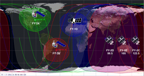
Table 1. List of launched Chinese meteorological satellites.
2. FY-3 mission and platform
2.1. FY-3 mission
Fengyun 3 is the second generation of Chinese meteorological polar-orbiting satellites. In the 1990s, concept design work for FY-3 started on the base of the FY-1 series. To meet new and higher requirements in modern meteorological services, especially in numerical weather predictions, the FY-3 series was designed to perform global, three-dimensional, quantitative and multi-spectral observations under all weather conditions (i.e. both cloud-free and cloudy conditions) with multiple sensors on board (Zhang Citation2001, Yang Citation2008).
As a new generation of polar orbiting meteorological satellite, the FY-3 series consists of two experimental and at least four operational satellites. The FY-3 series is expected to have a service life until 2020 (Yang et al. 2011a).
The first two satellites in the FY-3 series are research and development satellites (R&D). FY-3A was launched successfully on 27 May 2008, from the Taiyuan launch center. FY-3B was launched successfully on 5 November 2011, from the same launch site. FY-3A and FY-3B are designed the same and equipped with 11 payloads, but FY-3A is on a monitoring-orbit and FY-3B on an afternoon-orbit.
2.2. FY-3 platform
Fengyun 3 is on a sun-synchronous, near-polar orbit. The orbit altitude is about 830 km. The attitude control uses three-axis stabilization techniques with high control accuracy and stability. FY-3 is the most state-of-the-art Earth observation satellite in China. It has the greatest mass and the largest dimensions in civil remote sensing. The launch mass is about 2300 kg. The ground configuration size is 4380 mm×2000 mm×2000 mm. One solar panel is mounted on one side of the satellite's main body, which makes its span size in orbit 4440 mm×10,000 mm×3790 mm. Data (144 GB) can be stored on board to record the measurements from the 11 payloads. There is one L band and one X band for real-time data transmission, and another X band for delayed data transmission. The FY-3 data downlink follows the Consultative Committee for Space Data Systems (CCSDS) standards, which makes the FY-3 data format compatible with the National Polar-orbiting Operational Environmental Satellite System (NPOESS) and Meteorological Operational Satellite Programme (MetOp) satellite data transmission characteristics. The major technical specifications of the FY-3 platform are given in (Li and Dong Citation2008, Yang et al. Citation2009).
Table 2. Major technical specifications of the FY-3 platform.
3. FY-3 payloads
FY-3A and FY-3B are not only meteorological satellites but also Earth observation satellites. The comprehensive 11 payloads on board cover the electromagnetic spectrum from ultraviolet to microwave (Dong et al. Citation2009, Zhang et al. Citation2009). The specifications of the payloads are listed in . These 11 payloads can be categorized into five missions. They are optical imaging, microwave imaging, sounding, atmospheric chemistry, and Earth radiation budget missions.
Table 3. Specifications of the 11 payloads.
3.1. Optical imaging mission
The optical imaging mission is composed of two optical imagers. The purpose is to measure surface characteristics, such as the land, ocean, and clouds. The two optical imagers are Visible and Infrared Radiometer (VIRR) and Medium Resolution Spectral Imager (MERSI). VIRR is an AVHRR-like instrument. It is the only payload inherited from the FY-1 series to perform the successive observations operationally. VIRR carries out its measurements in 10 channels with a 2800-km swath width to obtain global coverage each day without any footprint gap left. The spatial resolution is 1.1 km at nadir. VIRR will stop its measurements after FY-3C.
Medium Resolution Spectral Imager is the update to VIRR. It is a MODIS-like instrument with 20 visible and infrared channels. The swath width is the same as the VIRR. MERSI holds five channels at 250 m spatial resolution at nadir and the other 15 channels at 1 km. MERSI improves the optical imaging capacity of the FY meteorological satellite from kilometer to hundred-meter resolution. To reduce the disk, MERSI will work together with VIRR on FY-3A, FY-3B, and FY-3C as well. After that, the advanced MERSI (i.e. MERSI II) will start its observation independently from FY-3D.
Medium Resolution Spectral Imager can provide true color composite images with 250 m spatial resolution globally every day since there are three RGB channels included. This characteristic makes MERSI more advanced in global environment and disaster monitoring than MODIS. MERSI has better image texture and image lumination since the MODIS true color image is taken only in 500 m spatial resolution globally.
3.2. Microwave imaging mission
The wavelength of the microwave can be longer than 1 mm. It is much longer in the electromagnetic spectrum compared with visible and infrared wavelength. Therefore, microwave can penetrate most non-precipitating clouds to reach the surface. In light of this, a microwave imager can work together with an optical imager to provide surface information under all weather conditions.
The microwave imager mounted on FY-3A and FY-3B is named the Microwave Radiation Imager (MWRI). MWRI is a 10-channel conical-scanning microwave radiometer at five frequencies. All frequencies are in double polarization. Spatial resolution is 15 km at 89 GHz and 85 km at 10 GHz. The swath of MWRI is about 1400 km. The soil moisture, land surface temperature, land surface emissivity at microwave, snow depth, snow water equivalent, etc. can be retrieved quantitatively from the microwave frequency difference or the polarization difference of MWRI measurements (Yang et al. 2011b).
At higher-frequency channels, such as 89 GHz, the measured microwave radiance principally comes from scattering interaction of clouds and precipitation. Therefore, the microwave radiance at higher-frequency channels is also a good indicator to detect rainfall over both land and ocean.
3.3. Sounding mission
The sounding mission is different from the imaging mission in its working channels. In order to detect the atmospheric temperature and moisture profile, the sounding mission selects the channels from the center to the wings of the absorption bands. The radiance at the center of the absorption represents the information from the upper atmosphere while the radiance at the wings represents the information from the lower atmosphere (Kaplan Citation1959).
The FY-3 sounding mission is similar to the current ATOVS mounted on the National Oceanic and Atmospheric Administration (NOAA) series; it is composed of three instruments named Vertical Atmospheric Sounding System (VASS). VASS includes Infrared Atmospheric Sounder (IRAS), Microwave Temperature Sounder (MWTS), and Microwave Humidity Sounder (MWHS). IRAS is a 26-channel IR radiometer for temperature and humidity sounding with a wavelength near the 15 µm CO2 absorption band, 6.7 µm water vapor absorption band, and 4.3 µm CO2 absorption band. Spatial resolution is 17 km and swath width is 2250 km. MWTS is a four-channel microwave radiometer with a frequency near the 54 GHz O2 absorption band. MWTS can provide temperature profile sounding under nearly all weather conditions with a spatial resolution of 70 km at 54 GHz. MWTS performs on cross-track scanning mode with a 2200-km swath. MWHS is a 5-channel microwave radiometer at four frequencies (one frequency in double polarization) near the 183 GHz water vapor absorption band. MWHS can provide humidity profile sounding under nearly all weather conditions. The spatial resolution is about 15 km. The swath width is 2700 km with cross-track scanning.
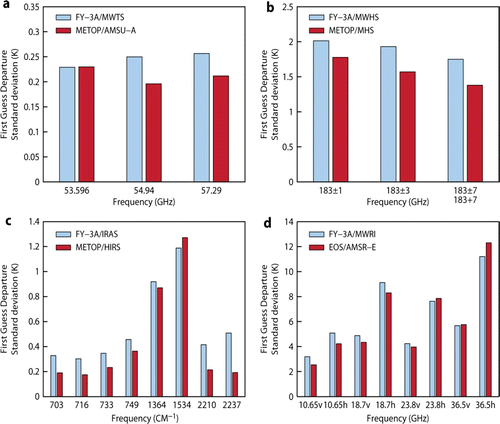
Data from the FY-3 sounding mission were introduced into the ECMWF Integrated Forecasting System to assess the data quality and the influence of the data on analyses and forecasts (Lu et al. Citation2011). An overview of the data quality for the key channels of the four FY-3A instruments, in terms of the standard deviations of the first-guess departures after variational bias correction (VarBC) and quality control, is given in . Also shown for comparison are the equivalent statistics for the corresponding MetOp-A instruments and, for the case of the MWRI instrument, the equivalent AMSR-E statistics. The statistics have been obtained over one month. An analysis of first-guess departures has shown the data to be of good quality overall. Guan et al. (Citation2011) also proved FY-3 sounding data to be of good quality. These initial results build confidence that FY-3 sounding data can contribute positively to NWP model forecasting.
Figure 2. Standard deviations of bias-corrected first-guess departures for FY-3A and MetOp-A/AQUA equivalent instruments and channels (Courtesy of Lu Qifeng, NSMC). Statistics are derived from data used in the period from 28 August to 28 September, 2008: (a) MWTS and AMSU-A, (b) MWHS and MHS, (c) IRAS and HIRS, and (d) MWRI and AMSR-E.
3.4. Atmospheric chemistry mission
Current FY-3 satellites meet their capacity on atmospheric composition remote sensing through a suite of two ultraviolet spectro-radiometers, Total Ozone Unit (TOU) and Solar Backscatter Ultraviolet Sounder (SBUS). TOU measures total ozone amount with six channels in the 308–360 nm range. Spatial resolution is 50 km with a 3000-km swath. SBUS measures ozone profile with channels in the range 252–340 nm, and spatial resolution is 200 km at nadir viewing without side scanning.
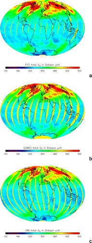
The total column ozone retrieval algorithm of TOU is similar to the algorithm used by TOMS/NIMBUS-7, OMI/AURA. The total column ozone is derived from a pair of measurements of backscattered solar ultraviolet radiation at two wavelengths where ozone absorption has apparent difference (Wang et al. Citation2010). The retrieval results are given in together with the results derived from GOME2/Metop and OMI/Aura. It shows that three products keep their retrieval accuracy within 5% in the global scale.
Figure 3. Global total column ozone distribution monitored by TOU/FY-3A (a), GOME 2/Metop (b), and OMI/Aura (c) (Courtesy of Wang Weihe, NSMC).
The ozone profile retrieval algorithm of SBUS is similar to the algorithm used by BUV/NIMBUS-4 and SBUV on the NOAA series. The ozone profile is deduced from 12 wavelengths in the ozone ultraviolet absorption spectrum with an iterative method of calculation of the radiation transfer equation (Huang et al. Citation2010a, Citation2010b).
The aerosol product can be derived from MERSI. The retrieval algorithm is more similar than the algorithm used by MODIS/EOS, and 0.47, 0.65, and 2.1 µm bands are used to retrieve aerosol over ocean and land, respectively (Yang et al. 2011a).
3.5. Earth radiation budget mission
The Sun is the only source to drive the Earth system. It is very important to measure the incoming solar irradiance and the outgoing longwave radiance at the top of the atmosphere. Such measurements are critical to evaluate current climate models and in climate research. Therefore, the NOAA has run the Earth radiation budget experiment (ERBE) on Shuttle Challenger, NOAA-9, and NOAA-10 since 1984. The National Aeronautics and Space Administration (NASA) has run the Clouds and the Earth's Radiant Energy System (CERES) experiment on TRMM, Terra, and Aqua since 1997.
The Earth radiation budget measurements on current FY-3 satellites are performed by a suite of two instruments, Earth Radiation Measurement (ERM) and Solar Irradiance Monitor (SIM). ERM is two broadband channel radiometers for Earth-reflected solar flux and Earth-emitted thermal flux over short (0.2–4.3mm) and total (0.2–50mm) wavebands. ERM has two working modes. One is cross-track scanning mode with a 28 km spatial resolution at a 2° narrow field of view (NFOV). The swath width is 2300 km. The other is nadir viewing mode with a 120° wide field of view (WFOV). SIM is a three-channel radiometer over a 0.2–50mm waveband for the total incident solar flux. It views the Sun near the North Polar area.
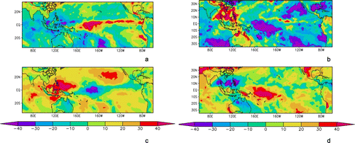
shows the global radiative anomalies in shortwave and longwave derived from ERM/FY-3 in an El Niño year (2010) and La Niña year (2011). The radiative anomalies were calculated from the seasonal mean of January, February, and March minus the climate seasonal mean from 1985 to 2009. The result shows that the El Niño year in 2010 increased the shortwave radiance and reduced the longwave radiance in the western Pacific region. However, the radiance anomaly pattern was the opposite in the year of La Niña at the same region.
Figure 4. Global radiative anomalies in shortwave and longwave derived from ERM/FY-3 in an El Niño year (2010) and La Niña year (2011). (a) Shortwave radiative anomalies in an El Niño year (2010), (b) shortwave radiative anomalies in an La Niña year (2011), (c) longwave radiative anomalies in an El Niño year (2010), and (d) longwave radiative anomalies in a La Niña year (2011) (Courtesy of Zhang Yan and Qiu Hong, NSMC).
4. The scheduled instruments on board on FY-3C and beyond
The FY-3 series is expected to obtain its measurements for at least 15 years with another four satellites. Sixteen payloads will be configured from FY-3C to FY-3F in the schedule, as listed in . During this period, the performance of some instruments will be improved and some new instruments will be mounted.
Table 4. Scheduled instruments on board FY-3C and beyond.
The improved instruments include MERSI II, MWTS II, MWHS II, SIM II, and ERM II. The advanced MERSI II will increase the channels from 20 to 25 after merging the VIRR channels. MWTS II will increase the channels from 4 to 13, and MWHS II will increase the channels from 5 to 15. The advanced MWTS and MWHS will provide the same sounding capability as AMSU. The advanced SIM can track the solar disk automatically to improve the accuracy of the measured solar constant. The advanced ERM will increase one broad channel to measure the outgoing longwave radiance directly.
Five new payloads will be developed. The Hyperspectral Infrared Atmospheric Sounder (HIRAS) is an IASI/Metop-like instrument to improve the measured temperature and moisture profile instead of the IRAS. Ozone Mapping Spectrometer (OMS) is a SCIAMACHY/Envisat-like instrument to detect the ozone and other atmospheric chemicals as well instead of the suite of TOU and SBUS. The total column content and the profile of trace gases can be retrieved from the nadir view and limb view separately. Wind Radar (WindRAD) will measure the sea wind. Greenhouse Gases Absorption Spectrometer (GAS) will measure CO2 and CH4 globally. GNSS Occultation Sounder (GNOS) will improve the measured temperature and moisture profile at the upper atmosphere.
5. Conclusions
China has become one of the few countries who operationally maintain sun-synchronous and geostationary meteorological satellites. Chinese meteorological satellites are becoming an important component of the space-based global observing system.
In comparison with the first generation of polar orbiting meteorological satellites in China, current FY-3 satellites are involved in microwave imaging, atmospheric sounding, atmospheric chemistry, and Earth radiation budget missions with the 11 payloads on board. The optical imaging mission has been improved from 1 km to 250 m. Therefore, FY-3A and FY-3B are not only meteorological satellites but also Earth observation satellites
FY-3A and FY-3B constitute a sun-synchronous constellation to provide global observation of the Earth four times per day. These observation data from the FY series have been broadly utilized in weather analysis, numerical weather forecasting, climate prediction, and environment and disaster monitoring. The innovation analysis between observation and simulation from the ECMWF Integrated Forecasting System has shown the FY-3 data to be of good quality overall.
Current FY-3 data delivery services include web-based services, FTP push service, FTP pull service, manual service, and CMACAST service. Users can access the data through the webpage (http://FY3.satellite.cma.gov.cn) after a quick registration.
The FY-3 series will provide greenhouse gas monitoring through a hyper-spectral radiometer, sea wind detection through active microwave radar, and upper atmosphere sounding through limb view measurements and GNSS radio occultation measurements. It is believed that the FY-3 series not only benefit the nation of China, but they are also a valuable contribution to the international meteorological, hydrological, and environmental community.
Notes on contributors
Jun Yang, Master Degree, is General-Director of National Satellite Meteorological Center (NSMC/CMA). He organized to define user requirements for Chinese Feng Yun meteorological satellite. He organized to build up satellite ground segment and operate the in-orbit Feng Yun satellites. He organized to receive and process satellite data from both Chinese and foreign meteorological satellite, and provide nationwide data and products service for weather forecast, environment monitoring, and disaster reduction.
Peng Zhang, Ph.D., is Head of the Office of System Development (OSD/NSMC/CMA), and has been Senior Project Scientist of the Chinese meteorological polar orbit satellite Fengyun 3 Series (FY-3) since 2007. Dr Zhang has been intensively involved in conceiving, developing, and operating the FY-3 satellite ground segment. He is responsible for operational product generation and data application of FY-3 series. His research experience focuses on atmospheric remote sensing and satellite data assimilation.
Naimeng Lu, Bachelor Degree, is Deputy-Director of NSMC/CMA. He is the Chief Project Manager of FY-3 series currently. He is the expert on precipitation and microwave remote sensing.
Zhongdong Yang, Ph. Degree. He is the Chief Project Scientist of FY-3 series. His research experience focuses on the satellite data geo-location and ecosystem remote sensing.
Jinming Shi, Bachelor Degree. She is the Senior Project Scientist of FY-3 series. She is responsible to design the archive and service, computer and network, operational control and schedule of FY-3 data.
Chaohua Dong, Bachelor Degree. She is the Former Chief Project Scientist of FY-3 series. Her research experience focuses on atmospheric sounding with satellite. She is the Senior Consultant of FY-3 Project currently.
Acknowledgements
This research was supported by the National Natural Science Foundation of China (Grant Numbers 41075021), the Key Project in the National Science & Technology Pillar Program of China (Grant Numbers 2008BAC40B01), and International Science & Technology Cooperation Program of China (Grant Numbers 2010DFA21140). Many thanks to Jun Li, CIMSS/University of Wisconsin Madison for his kind review of this paper. The authors are also pleased to acknowledge the people who have made contributions to FY-3 and its ground segment developments.
References
- Dong , C.H. 2009 . An overview of a new Chinese weather satellite FY-3A . BAMS , 90 ( 10 ) : 1531 – 1544 .
- Fang , Z.Y. , Xu , J.M. and Zhao , F.S. 2004 . Progress and prospect of China meteorological satellite and satellite meteorology . ACTA Meteorological Sinica , 62 ( 5 ) : 550 – 560 .
- Guan , L. , Zou , X.L. , and Weng , F.Z ., 2011 . Assessments of FY-3A microwave humidity sounder measurements using NOAA-18 microwave humidity sounder . Journal of Geophysical Research , 116 D10106 . doi: 10.1029/2010JD015412 .
- Huang , F.X. 2010a . Vertical ozone profiles deduced from measurements of SBUS on FY-3 satellite . Chinese Science Bulletin , 55 ( 10 ) : 943 – 948 .
- Huang , F.X. 2010b . Comparison and evaluation of retrieved ozone profiles from solar backscatter ultraviolet sounder on FY-3A satellite . Optics and Precision Engineering , 18 ( 7 ) : 1568 – 1576 .
- Kaplan , L.D. 1959 . Inference of atmospheric structure from remote radiation measurements . Journal of the Optical Society of America , 49 : 1004 – 1007 .
- Kidder , S.Q. and Vonder Haar , T.H. 1995 . Satellite meteorology: an introduction , San Diego : Academic Press .
- Li , Q. 2001 . Development of Chinese geostationary meteorological satellite . Spacecraft Recovery and Remote Sensing , 22 ( 1 ) : 13 – 19 .
- Li , Q. and Dong , Y.H. 2008 . Achievement and forecast of meteorological satellite technology in China . Aerospace Shanghai , 1 : 1 – 10 .
- Lu , Q.F ., et al. , 2011 . An evaluation of FY-3A satellite data for numerical weather prediction . Quarterly Journal of the Royal Meteorological Society . doi: 10.1002/qj.834 .
- Meng , Z.Z. 2004 . The polar orbit meteorological satellite in China . Engineering Science , 6 ( 10 ) : 1 – 5 .
- Wang , W.H. 2010 . Analysis for retrieval and validation results of FY-3 Total Ozone Unit (TOU) . Chinese Science Bulletin , 55 ( 26 ) : 3073 – 3043 .
- Yang , J. 2008 . Development and applications of China's Fengyun (FY) meteorological satellite . Spacecraft Engineering , 17 ( 3 ) : 23 – 28 .
- Yang , J. 2009 . FY-3A: the new generation polar-orbiting meteorological satellite of China . Acta Meteorologica Sinica , 67 ( 4 ) : 501 – 509 .
- Yang , J. 2011a . Operational products and application of new generation Fengyun polar-orbiting meteorological satellite , Beijing : Science Press .
- Yang , H ., et al. , 2011b . The FengYun-3 microwave radiation imager on-orbit verification . IEEE Transactions on Geoscience and Remote Sensing , 49 11 4552 – 4560 .
- Zhang , W.J. 2001 . Status and development of FY series of meteorological satellites . Aerospace Shanghai , 2 : 8 – 13 .
- Zhang , P. 2009 . General introduction on payloads, ground segment and data application of Fengyun 3A . Frontiers of Earth Science in China , 3 ( 3 ) : 367 – 373 .