Abstract
Developing the Nabucco engineering infrastructure was the most challenging task imaginable and required state-of-the-art technologies. For this purpose, a Nabucco-Global Positioning System (GPS) Network was established. It is 762 km long. Nine-hundred and two ground control unit points were established. In order to provide the relationship with ITRF96 datum, it was surrounded by TFNGN (Turkish Fundamental National GPS Network) and TNVCN (Turkish National Vertical Control Network) checkpoints. GPS observations were evaluated in the form of a unique network. After being reduced to projection segments, coordinates in ED50 datum were provided between datums by 2D-Helmert Transformation. Orthometric heights related to the GPS Network were obtained by the improvement of TG-03 data based on a GPS/leveling procedure. The objective of the study is to present the results of a comprehensive engineering project which involved many geodetic considerations including GPS, orthometric heights, and geoid undulations and gives insight into the accuracy and precision of such large projects in terms of recent geodetic practice. In this study, a Global Navigation Satellite System (GNSS)-based geodetic infrastructure is presented, methods to obtain the necessary precision requirements are provided, and experience is shared in order to provide an example of a large-scale pipeline project, and to provide insight into the planning necessary for future similar engineering projects.
Keywords:
1. Introduction
The purpose of the Nabucco Natural Gas Pipeline Project is to meet the gas needs of the countries along the route of the initial stage of the Turkey–Bulgaria–Romania–Hungary–Austria line, by which European countries will be able to utilize Middle East and Caspian Region natural gas reserves. In addition, the pipeline aims to supply Western Europe according to the changes in the gas demand of other countries, by taking advantage of Austria being a natural gas distribution point in the coming years. It is planned that the final capacity of the Nabucco Natural Gas Pipeline Project, which is within the scope of an Inter-Governmental Agreement, shall be 31 billion m3/year, and the project shall be initially commissioned in 2015. The total length of the pipeline, including feeding lines, is 3300 km. Approximately 2500 km of this line passes through Turkey (Nabucco Citation2011).
The technical feasibility work for the Nabucco Natural Gas Pipeline Project was conducted in 2004. Engineering services for the western part of the Turkish section of the Project was conducted by a consortium of the Su YapI & Sebat Harita Engineering Groups. The contract related to the project was signed on 22 April 2009. Just after the route survey work had been completed, planning work for the Ground Control Points was initiated.
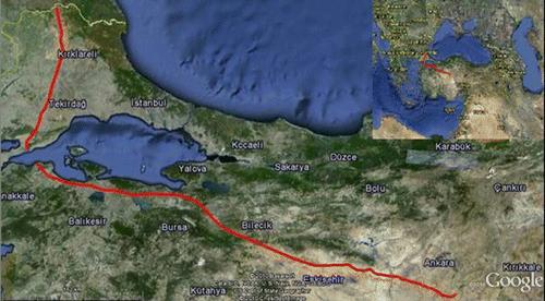
The first part of the Turkish section started in Ahiboz-Ankara (km: 0 + 000) and reached the Bulgarian border around Malkoçlar Village (km: 758 + 741) after passing through Eskişehir, Bursa, Bilecik, BalIkesir, Çanakkale, Tekirdağ, and KIrklareli provinces ().
The scope of the Project includes route pre-selection, ortho-photo maps, the constitution of Numerical Land Elevation Models based on the LIDAR procedure, the Marmara Sea Passage, an Environmental Impact Evaluation (EIE), nationalization services, an Immovable Assessment, a line survey and geologic, geotechnical, hydro-geological surveys of the line, engineering services for all structures based on the Project design and the establishment of Geographic Information Systems (GIS).
2. Site selection for the GPS Network check points and GPS Network design works
A technical feasibility study for the Turkish section of the pipeline was completed by the Boru HatlarI ile Petrol TaşIma Anonim Sirketi (BOTAS)/BOTAS Petroleum Pipeline Corporation in 2004. Survey studies for the route corridor for the western part of the Turkish section of the pipeline were conducted by the contractor company, the Su YapI & Sebat Engineering Group. The pipeline pre-route was approved by BOTAS on 17 September 2009. With regard to the pre-route, work for site selection of the Ground Control Points belonging to the pipeline was carried out in compliance with the Large Scale Map and Map Information Production Regulation. With regard to the pipeline route, TFNGN (Turkish Fundamental National GPS Network) points (Ayhan et al. Citation2002, Tuşat Citation2010), C grade points, and TNVCN (Turkish National Vertical Control Network) (Ayhan and Demir Citation1992) points to be used for GPS leveling purposes were included in a site selection plan. Site selection plan which was established was approved by the General Directorate of Land Registry and Cadastre on 15 September 2009.
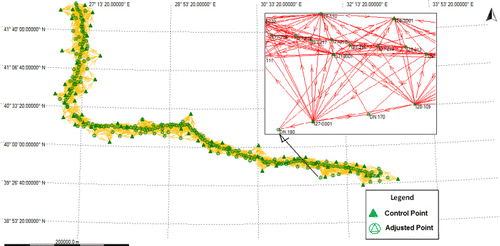
The Horizontal Check Network (Triangulation Network) which was established to carry out all the engineering works for the western part of Turkish section of the pipeline – the Ankara-Bulgaria route (km: 758 + 741) – was surrounded by 29 units of TFNGN, 45 units of C grade check points, and 61 units of TNVCN points, the coordinates of all of which were known precisely. For densification of GPS Network, 67, 131, and 704 units of location check points with C1 grade, C2 grade, and C3 grade were installed, respectively ().
Ground Control Points were installed on land within the criteria indicated in the Large Scaled Map and Map Information Production Regulation. All the C1 grade points and the C2 grade points were installed as pier mounts (65 units and 131 units, respectively), and the C3 grade points were installed as 4 units of pier mounts, 63 units of nail (rock blocks), and 617 units of concrete blocks. The ground installation and benchmarks of the Ground Control Points were accordingly checked by the General Directorate of Land Registry and Cadastre on the premises, and approved on 23 November 2009.
3. GPS measurements
GPS measurements of the Nabucco Natural Gas Pipeline between Ankara and Bulgaria were completed between 4 October and 16 November 2009 with 15 units of dual frequency GPS receivers having a horizontal accuracy of 3 mm + 0.5 ppm and a vertical accuracy of 6 mm + 0.5 ppm (Leica Citation2010). In order to eliminate antenna elevation errors and directional errors, antennas have all been directed toward the north, and antenna heights have been measured by special apparatus in two occasions – one at the beginning of the measurement and one at the end, and the results have been recorded accordingly (Sickle Citation1996). The data collection interval was configured as 10 seconds for all 15 receivers, whereas the cut-off angle was configured as 15 degrees. In this way, the data gathered with regard to the 15 receivers were implemented simultaneously in the same configuration. Measurements were initiated from Ankara and terminated at the Turkish–Bulgarian border. At TFNGN, C1 and C2 degree points, at least 1080 epoch data have been collected, whereas at the C3 degree points at least 180 epoch data have been collected (Epoch is a specific instant in time.) GPS carrier phase measurements were made at a given frequency (e.g. every 10 seconds) or epoch rate (CGCC Citation2011). GPS measurements, for each point, were implemented where the base vector consisted of at least three reference points.
4. Process of the GPS base vectors
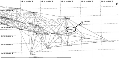
GPS measurement evaluations were accomplished using the LGO 5.0 software (version 5.0) developed by LEICA, as a whole in a single unit under the consideration of the integrity of the project. In all base measurements, the initial phase unknowns (ambiguity) were solved correctly. For the base vector solution strategy, the maximum discrepancy between different solutions for position was 0.03 meters, and the maximum discrepancy between different solutions for height was 0.05 meters. Process parameters were selected as default and broadcast ephemeris was used. According to Deniz et al. (Citation2008), for the solution of some vectors, a maximum of 25 km bases were taken into evaluation; bases exceeding 25 km were not taken into consideration. For the solution of base vectors, at the beginning of the project, the process was initiated using Single Point Positioning (SPP) from points number I29-102 with a pier mount installation and having the best quality of measurement and period (). For the best SPP solution, 1980 epoch data were stored at I29-102. Subsequent simultaneous observations were solved respectively. For solutions, at least three points which were solved on the previous day were included in a measurement plan at the start of the next day. The accuracy of the solutions was checked by loop closing.
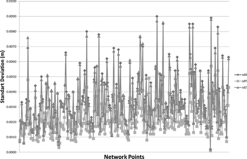
For the pre-solutions of some vectors, log files have been closely examined, and the effect of the cycle-slip and defective satellites have been determined and taken out of the evaluation. Consequently, optimum accuracy was obtained. In terms of probable antenna height faults, control was provided by field sheets prepared by the operators. At the end of each day, raw data obtained from the receivers were compared with the measurement plan, and point numbers which were recorded incorrectly were regulated again and backed up in a dd.mm.yyyy directory structure and in RINEX format. In , base solutions have been determined, and the GPS Network with a total length of 758 km has been provided. Due to the solution of the base vectors, standard deviation values were obtained as the maximum; σ X=±0.0090 m, σ Y=±0.0057 m, and σ Z=±0.0088 m. In , standard deviation quantities obtained due to the solution of the base vectors have been provided.
5. Scale and congruence tests
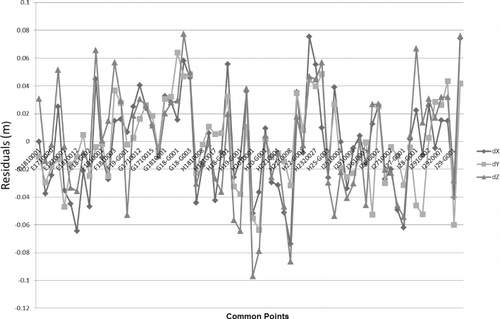
Turkish Fundamental National GPS Network which exists in Turkey is at ITRF96 datum and 2005.00 epoch. The Nabucco West GPS Network which was composed accordingly should be connected with TFNGN, and the C degree control points have been included within the Network, by TFNGN. Nabucco West GPS Network measurements have been executed at 2009.80 epoch and have been shifted to 2009.80 epoch with the assistance of annual velocity vectors, and the 2005.00 reference epoch coordinates of points the locations of which are well known. The coordinate couples obtained from shifted coordinates and base vector solutions have led to the accomplishment of a 3D-Helmert Transformation upon the Bursa-Wolf Transformation Model (Bursa Citation1962, Wolf Citation1963, Aktuğ Citation2009). For the solution of the GPS Networks, a scale factor was required due to the fact that the transformation cannot exceed 1–λ=±3 ppm (Deniz et al. 2008). The scale factor to be obtained in Nabucco GPS Network solutions is −0.0047 ppm (). The residual values of common points executed at 2009.80 epoch and obtained due to the Helmert Transformation of matching points have been provided.
6. Adjustment of the Nabucco GPS Network
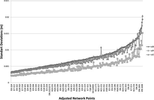
Common net points at 2009.80 epoch have been taken without any alteration of coordinates in the Nabucco West GPS Network. Some solutions have been completed and forced balancing has been accomplished. For the balancing calculation, the number of known stations was 69, the number of unknown stations was 205, and 6567 GPS coordinate differences have been evaluated. Due to the adjustment calculations, the highest standard deviations of σ X=±0.0194 m, σ Y=±0.0153 m, and σ Z=±0.0205 m have been obtained (). The distribution of the standard deviations calculated due to an adjustment of the fixed networks has been given. Coordinate values at 2009.80 epoch obtained in adjustment of fixed networks have been fixed to 2005.00 reference epoch with Cartesian coordinates at 2005.00 reference epoch of at least three units of TFNGN and their annual velocity vectors (Vx, Vy, and Vz) as well as with linear interpolation.
7. GPS leveling survey and evaluation
In order to specify Helmert orthometric elevations of control points in the Nabucco West GPS Network, 35 units of TNVCN points were distributed appropriately with the project field. These have been included within the GPS measurements in order to check antenna height faults. At each point, GPS observations were made simultaneously in 2 different periods for 2 hours each. In addition, geometrical leveling has been performed between reliable TNVCN control points with regard to which the Helmert orthometric elevation was known.
In this study, using TG-03 (Kilicoglu and Firat Citation2003) which has been calculated as a geoid model which is new and which includes more data, Generic Mapping Tool (GMT) (Wessel and Smith Citation1998) codes were used in the calculations.
In control points with regard to which Helmert orthometrics (H) and ellipsoid elevations (h) are known, the differences between TG-03 geoid elevations (N=h-H)TG-03 were calculated (). In , calculated N(tg03)–N(ort) differences, the mean value, and RMS value of TNVCN check points are given. Differences obtained have been brought into the models using third-degree polynomials. TG-03 geoid corrections (δN) have been determined with regard to all points. The Helmert orthometric elevation has been determined by the equation H = h-(NTG-03+δN). This procedure can also be defined as the utilization of the gravimetric geoid model which was being updated by local GPS/leveling measurements. In terms of control points, prior to the differences (δN) of GPS/leveling geoid heights and TG-03 geoid heights, the trend surface (t) has been calculated and waste measurements (dN) have been found by N = δN–t. Thus, updated geoid elevations have been calculated using the formula NNBCC-03=NTG-03+dN + t. In , the statistical information concerning updated geoid heights which were modeled through third-grade polynomials is presented.
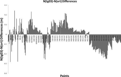
Table 1. N(tg03)–N(ort) differences.
Table 2. Updated geoid results.
8. ITRF96-ED50 datum transformations
In terms of project integrity, the Nabucco Natural Gas Pipeline (Zone: 27_3, Zone: 30_3, and Zone: 33_3) ITRF96-ED50 Helmert 2D transformation which has passed through three different Gauss–Kruger projection segments has been accomplished by a total of 15 units of set parameters. Reasons for not being able to determine a transformation parameter which covers all the project area are (1) the difference of the internal sensitivity of the polygon serials used for the calculation of common points in ED50 datum and (2) the deterioration of point sensitivity of dislocations/fault moves in several magnitudes since 1950 until today. gives statistical information related to transformation parameter sets.
Table 3. ITRF96-ED50 2D-Helmert Transformation Statistics.
9. Results and conclusion
For the solution of the Nabucco West GPS Network, the difference in the solutions coming from separate bases has not exceeded 3 cm maximum at the horizontal position and 5 cm maximum at the vertical position. At the end of the solutions, standard deviations have been provided as follows: maximum σ lat=±0.0075 m, σ long=±0.0052 m, and σ height=±0.0136 m. These values are compatible with the Large Scale Map and Map Information Production Regulation.
Scale and congruence tests are important criteria for GPS Networks. For the Nabucco GPS Network Solutions, scale and congruence tests have been performed with a total of 75 unit control points, of which coordinates have been calculated at ITRF96 datum 2009.80 measurement epoch, and 69 points have been found to be matching. The results of the scale and congruence tests were as follows: σ aposteriori: ±0.0373 m, scale factor: −0.0047 ppm. The largest coordinate correction was obtained as dX = 7 cm, dY = 4.18 cm, and dZ = 7.6 cm. These values are valid for point number J30-G001.
Geodetic precision is usually a function of the project area and the baseline lengths of the network points. Most physical or geometric phenomena, such as variation of geoid, distortion of the control network, or accuracy limitations of leveling lines, is directly related to the extension of the project. In this respect, technical aspects for large projects such as the one discussed here require special care. In this study, we demonstrated the basic guidelines required for an engineering study spanning several countries. The obtained precision shows that even larger projects can potentially be realized with similar geodetic precision.
Through the criteria obtained due to scale and goodness of fit tests, at 2009.80 measurement epoch, forced balancing was performed with 69 matching points. Due to adjustments of the fixed network, again within the scope of the Large Scaled Map and Map Information Production Regulation, standard deviation values have been found as follows: σ Φ, σ λ<±3 cm and σ h<±5 cm. Point coordinates calculated at 2009.80 epoch have been made subject to linear interpolation with a velocity area data of TFNGN points surrounding the points, and in ITRF96 datum and in 2005.00 reference epoch, coordinates have been calculated.
The standard deviation, which was obtained using NTG-03 data directly at the Helmert orthometric elevation calculations of points by GSP leveling, has been found to be ±11 cm. Standard deviation which was obtained by using improved N values has been calculated as ±4.2 cm, and elevation values of other points have also been calculated.
Due to ITRF96-ED50 2D-coordinate transformations (east and north axes), in the transformation of points entering into common areas covered by two parameter sets adjacent to each other on the Anatolia side, the major differences have been found as follows: Δeast =−13.8 cm and Δnorth = 12.3 cm, whereas on the European side it was Δeast =−15.3 cm and Δnorth =−16.3 cm.
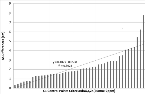
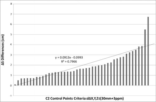
The accuracy of all measurements and calculations performed were checked by further measurements and calculations in different periods and at different control points and were determined by the Administration. At the end of the control period, the biggest location difference at C1 degree points was found to be Δs = 5.5 cm (), whereas the biggest location difference at C2 degree points was found to be Δs = 6.2 cm ().
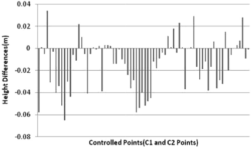
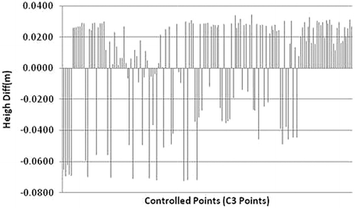
The Helmert orthometric elevation values obtained from TG-03 (Turkey Geoid) data were checked by the Administration using measurements and calculations at different control points. Due to control measurements and calculations at C1 and C2 degree points, the highest difference was found as ΔH = 0.065 m (). In terms of the elevation controls of points of which heights have been calculated by interpolation from the model consisting of TG-03 data, the highest difference was calculated as ΔH = 0.072 m ().
Ground Control Points produced for engineering services carried out within a 762-km-long and 2-km-wide corridor, which was selected as the working area of the Turkey section west as part of the Nabucco Natural Gas Pipeline Project, was checked and approved by the General Directorate of the Land Registry and Cadastre, and was subsequently loaded into the Map Information Bank to allow access to interested parties from all over the world.
As a result, the transportation of the natural gas from the source area to the other areas in need through the state-of-art technologies provides an invaluable example of application of geosciences. The usage of space-based techniques ensures the necessary precision of pipeline orientation in 3D space over hundreds of kilometers. The presented work does not only comprise the application of such large civil projects but also covers a conglomerate of many geosciences and computerized methods including but not limited to GPS and various Geo-spatial science applications. The introduced GPS Network provides the necessary digital infrastructure for the project which includes many technologies ranging from Digital Elevation Models (DEM), Laser Imaging Detection and Ranging (LIDAR) to the establishment of GIS within the project. In this respect, the presented application shows a typical digital framework for data processing, data fusion, and integration.
Acknowledgements
The author thanks Sebat Proje, Mr. Zeki ÖZTÜRK, and Mr. A. Fahri ÖZTEN for their support.
References
- Aktuğ, B., 2009. Invers and compound datum/frame transformations. Journal of Surveying Engineering, 135 (2), 46–55.
- Ayhan, M.E. and Demir, C., 1992. Turkish national vertical control network. Journal of Mapping, 109, 17–27.
- Ayhan, M.E., et al., 2002. Turkish national fundamental GPS network (TFGN-99A). Journal of Mapping, 16, 1–67.
- Bursa, M., 1962. The theory for the determination of the non-parallelism of the minor axis of the reference ellipsoid and the inertial polar axis of the Earth, and the planes of the initial astronomic and geodetic meridians from observations of artificial Earth satellites. Studia Geophysica et Geodetica, 6, 209–214.
- CGCC, 2011. Glossary of GPS terminology [Online]. California Spatial Reference Center. Available from: http://www.rbt.com/cgcc/index.htm [Accessed 30 November 2011].
- Deniz, R., et al., 2008. Regulation on large scale map productions with explanation and examples. Ankara, Turkey: Chamber of Survey and Cadastre Engineers.
- Kilicoglu, A. and Firat, O., 2003. Geoid modeling and applications for orthometric height determination with GPS in large scale map production. In: Proceedings of the geographical information systems and geodetic networks workshop, scientific meeting of TNGC, 24–26 September 2003. Konya, Turkey: Selcuk Univ.
- Leica, 2010. User manual. Heerbrugg, Switzerland: Leica Geosystems, AG.
- Nabucco, 2011. Nabucco gas pipeline project [Online]. Available from: http://www.nabucco-pipeline.com/portal/page/portal/en [Accessed 6 September 2011].
- Sickle, V.V., 1996. GPS for land surveyors. Chelsea, MI: Ann Arbor Press, Inc.
- Tuşat, E., 2010. The importance and development of national geodetic networks in map production: a Turkish case study. International Journal of the Physical Sciences, 5 (15), 2310–2316.
- Wessel, P. and Smith, W.H.F., 1998. New improved version of GMT. EOS Transactions American Geophysical Union, 79, 579.
- Wolf, H., 1963. Geometric connection and re-orientation of three-dimensional triangulation nets. Bulletin Géodésique, 68, 165–169.