
ABSTRACT
The development of global informatization and its integration with industrialization symbolizes that human society has entered into the big data era. This article covers seven new characteristics of Geomatics (i.e. ubiquitous sensor, multi-dimensional dynamics, integration via networking, full automation in real time, from sensing to recognition, crowdsourcing and volunteered geographic information, and service-oriented science), and puts forward the corresponding critical technical challenges in the construction of integrated space–air–ground geospatial networks. Through the discussions outlined in this paper, we propose a new development stage of Geomatics entitled ‘Connected Geomatics,’ which is defined as a multi-disciplinary science and technology that uses systematic approaches and integrates methods of spatio-temporal data acquisition, information extraction, network management, knowledge discovery, and spatial sensing and recognition, as well as intelligent location-based services pertaining to any physical objects and human activities on the earth. It is envisioned that the advancement of Geomatics will make a great contribution to human sustainable development.
1. Emergence and evolution of the big data era
In September 1993, the United States launched an ‘Information Superhighway’ program, namely, the National Information Infrastructure (NII), which triggered a worldwide information revolution. On a par with the NII, China initiated the ‘Eight Gold’ project in 1995 to promote its own NII, marking the emergence of China’s urban information construction. As a further development, in 1994, the United States started the construction of the National Spatial Data Infrastructure, which received positive responses from various countries. With efforts on combining satellite navigation and positioning technology, satellite remote sensing technology, web geographic information technology, and virtual reality technology, a virtual cyber space was created by incorporating a huge amount of data and information as well as their geometric and social attributes that characterize physical objects and human activities.
In 1998, the former US Vice President Al Gore introduced the concept of ‘Digital Earth,’ marking the inception of Digital Earth (Gore Citation1998). Since then, China has built a basic national digital geospatial data framework. More than 600 cities in China have started implementing the basic digital city framework. The ‘Map World’ (Gong et al. Citation2010), released on the Internet by the National Administration of Surveying, Mapping and Geoinformation of China, has become the major carrier of Digital China and digital cities and is currently accessed by hundreds of millions of Internet users.
New-generation information techniques, such as the Internet of Things and cloud computing, were officially introduced in 2006, achieving a comprehensive integration of industrialization and informatization. The digital world is connected with the real world through a ubiquitous sensor network, forming a cyber-physical space. In this space, the status of and changes experienced by people and things in the real world will be perceived by an automatic and real-time sensor network. Cloud computing can process massive and complex computations, generate intelligent feedback, and provide intelligent services for various aspects of human society, including mankind’s survival and reproduction, economic development, social interaction, and enjoyment of culture. The construction of these information techniques helps to promote low-carbon, green, and sustainable social development. By 2009, more than 50 countries around the world had formally proposed their plans for a smart earth and smart city construction.
The journal Nature published a special issue entitled Big Data (Howe et al. Citation2008); similarly, the journal Science published Dealing with Data (Reichman, Jones, and Schildauer Citation2011), both noting that the big data era has arrived. In March 2012, the Obama Administration announced the official release of the ‘Big Data Research and Development’ initiative and officially launched this program. The significance of this program is comparable to that of the ‘Information Superhighway’ plan in the twentieth century. Regardless of the scientific community and political forums, people have garnered a common understanding that big data will be immensely useful for information mining and knowledge creation. With the construction and application of smart earth and smart cities, a plethora of heterogeneous sensors around the world will generate increasingly more data. As a result, the magnitude of data will increase from the current GB (gigabyte) and TB (terabyte) size to PB (petabyte), EB (exabyte), or even ZB (zettabyte) size. If these complex and massive data can be thoroughly analyzed and integrated (Gong, Li, and Wu Citation2014; Shan et al. Citation2014) with the support of cloud computing, they can be transformed into an invaluable source of information. This will be greatly helpful in exploring, analyzing, and mining the laws of nature and social development, people’s lives and behaviors, social trends, and public opinion trends, and in predicting responses to products, services, and even public policies. An era of using large-scale effective data to analyze, predict, model, visualize, and discover new trends and patterns is therefore about to commence (Craglia et al. Citation2012; Evans et al. Citation2014; Manfred et al. Citation2014; Li, Wang, and Li Citation2015).
As previously defined, big data is distinguished by five characteristics:
Volume: the quantity of generated and stored data reaches the level of TB, PB, EB, or even ZB.
Variety: the type and nature of the data are variable, leading to the coexistence of multi-measure, multi-structure, and multi-source data in the form of texts, images, videos, etc.
Velocity: data, which are constantly generated in hours, minutes, seconds, or even milliseconds, require efficient processing to meet the users’ demands.
Veracity: the quality of captured data varies greatly; data uncertainty, resulting from data noise, missing data, inconsistency, and ambiguity, can affect the accuracy of analyses.
Value: big data enables the quantification and understanding of the world from an unprecedented perspective and is thus of great value. The ultimate aim of big data is to extract the hidden value in the data.
Big data contains not only information but also a wealth of knowledge. Such knowledge is not directly obtained but rather immersed within the ocean of data. To obtain it, we must conduct in-depth data mining. However, due to the data volume, velocity, variety, and veracity, it is difficult to effectively extract the useful information from big data. It is especially difficult to conduct data mining on a dataset containing spatio-temporal information, resulting in a situation of ‘massive data, missing information, and unavailable knowledge.’ Therefore, it presents an unprecedented challenge for the development of encompassing theories and algorithms for spatio-temporal data mining (Li, Zhang, and Xia Citation2014), including data heterogeneity and retrieval, data selection, semantic description, semantic interpretation, uncertainty, and knowledge representation.
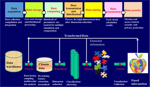
Spatio-temporal data mining is a process for automatic discovery and extraction of implicit and non-apparent patterns, rules, and knowledge residing in the massive and multi-source spatio-temporal big data. Obviously, data mining is more difficult than simple data processing and information extraction, as it requires intelligent reasoning approaches based on expert knowledge bases (see ).
Figure 1. Process of spatio-temporal data mining.
2. New characteristics of Geomatics in the big data era
The information revolution and the Internet revolution expedited the development of Geomatics in the 1990s. Geomatics is the intersection and fusion of the fields of surveying, mapping, remote sensing science, and information science. As a key branch of geoscience, Geomatics provides a technical spatial coordinate framework, a mathematical basis, and information processing technologies to geoscience research. In addition, through integrating and analyzing multi-platform, multi-scale, multi-resolution, and multi-temporal space–air–ground observational data in cognitive ways, Geomatics has greatly improved our ability to observe the earth (Li Citation2012). Geomatics can provide human beings with a considerable amount of spatio-temporal information with high fidelity for accurate and comprehensive decision-making in various application fields. Geomatics has played an increasingly important role in the construction of Digital Earth and digital cities over the past 20 years.
As mankind eases into the era of smart earth and big data, we summarized the major new characteristics of Geomatics in the following seven aspects:
2.1. Ubiquitous sensor
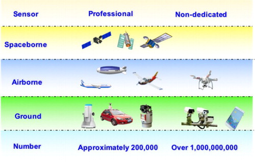
In the big data era, the instruments used to acquire geo-information will expand from conventional specialized space–air–ground sensors, such as satellites, airplanes, and Unmanned Aerial Vehicles (UAVs), to billions of non-dedicated sensors connected with the Internet of Things (Cha et al. Citation2016), such as webcams and smartphones (). For example, a smartphone acts as a spatio-temporal data sensor with communication, navigation, positioning, photo/video imaging, and broadband data transmission functions. With the increase in annual growth rate of global mobile phone users to 7% in the last 5 years, there were almost as many mobile-cellular subscriptions as people on earth at the end of 2016 (http://www.itu.int/en/mediacentre/Pages/2016-PR53.aspx). It is reported that customer-level annual sales of civilian UAVs at the global scale were boosted from approximately 60 thousand to 430 thousand during 2013–2015. Chinese annual sales of civilian UAVs reached 39 thousand in 2016, and it is predicted that this volume will exceed 3000 thousand in 2019 (http://www.cs.com.cn/ssgs/hyzx/201608/t20160819_5037730.html). These ubiquitous sensors will greatly enhance Geomatics data acquisition ability. Big data enables geospatial information to be disseminated more widely, and to benefit from new data sources, expanding through the Internet of Things towards Digital Earth (Jeansoulin Citation2016). In the big data era, Geomatic data have the classical characteristics of big data (‘Volume’ and ‘Variety’), and the application of Geomatics is becoming increasingly omnipresent, expanding from expert users to global public users.
Figure 2. Ubiquitous space-borne, air-borne and ground-based geospatial sensors.
2.2. Multi-dimensional dynamics
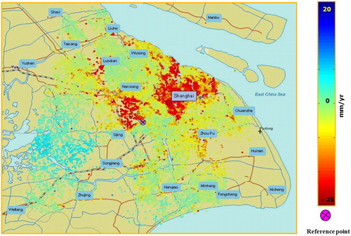
In the big data era, ubiquitous sensor networks can continuously acquire spatio-temporal data in days, hours, minutes, seconds, or even milliseconds, allowing people to obtain multi-dimensional dynamic information about various entities and human activities on the earth at an unprecedented rate. With the help of sensor networks, people can generate high-precision 3D models to construct an integrated geographic environment, including indoor/outdoor and aboveground/underground environments. Using integrated multi-angle tilt photogrammetry technology, precise 3D modeling of the earth’s surface can be readily accomplished, as shown in . Combining underground (underground pipeline detectors, depth detectors, etc.) and topographic survey techniques, we can build an integrated aboveground/underground 3D visual model (see ), which forms the basic infrastructure of a smart city. Based on multi-temporal analysis of interferometric radar images, people can obtain information on dynamic surface subsidence. As shown in , much higher subsidence rates have been detected in the Shanghai urban center using such techniques.
Figure 3. 3D modeling through multi-angle tilt images.
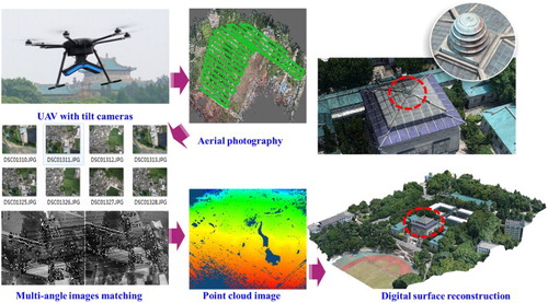
Figure 4. Subsidence rate of the ground surface in Shanghai determined from PS-InSAR multi-temporal data analysis.
In the big data era, Geomatics has greatly expanded the dimensions of human observation and understanding of the earth and natural environment, providing sustained theoretical support and technical means to enable the precise and real-time analysis of nature, society, and human activity. By enabling analyses of multi-dimensional temporal dynamic geo-information, Geomatics will play an increasingly important role in the sustainable development of human society. The methods developed in Geomatics through these studies will also make a substantial contribution to the fields of pattern recognition and artificial intelligence.
2.3. Integration via networking
Under the auspices of increasingly powerful integrated communication and cloud computing techniques, space–air–ground sensor networks will be fully integrated into the Internet of Things on the smart earth, forming an ‘Internet and Networking’ system. Therefore, the application of Geomatics is expanding from professional aspects to public aspects, as has been evidenced by Google Maps. Originally distributed and separate data processing, information extraction, and knowledge discovery tasks will be executed by cloud computation. Remote sensing clouds and Location-Based Service (LBS) clouds are examples of such integration (Li Citation2012).
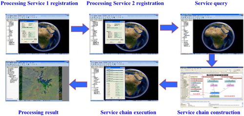
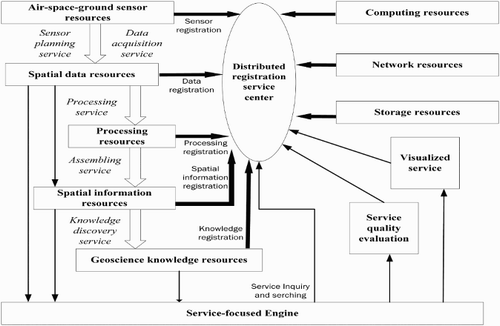
Remote sensing clouds provide a mechanism for the sharing and automatic control of computing resources, network resources, and storage resources. These cloud-based systems effectively organize the distributed resources, including multiple sensor resources, spatial data resources, processing algorithms, software resources, geoscience knowledge resources, and modular workflow resources. These resources are cooperatively organized via a registration service center. For example, the OpenRS-Cloud platform developed by Wuhan University releases data and algorithms through a visual desktop application under the support of a registration service center. Developers around the world have registered their designed data processing module or data resources with unique interface specifications on the remote registration center via the Internet. After the user’s demands are received, available processing modules can be queried through a user interface; then, an abstract service chain is established according to the user’s requirements and the existing processing module. Finally, the abstract service chain is mapped to the Business Process Execution Language service execution chain. The processing result is then returned to the user. shows the workflow of the OpenRS-Cloud service.
Figure 5. Workflow of the OpenRS-Cloud service.
2.4. Full automation in real time
In response to the ‘velocity’ characteristics of big data, Geomatics enables the full automation of observational data in a timely manner to meet the requirements of emergency response and real-time applications (Bedard Citation2014), under the support of networking and cloud computing.
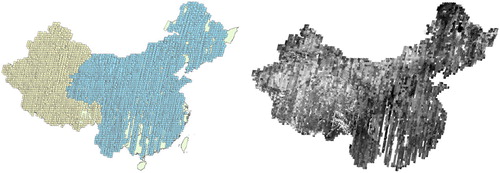
In the case of automatic data processing of Chinese ZY-3 satellite imagery, for the purpose of the overall geometric correction of 8810 scenes of imagery (original data volume of 20 TB) covering almost the entire area of China (see ), approximately 2 billion corresponding points were automatically matched using 15 distributed computing nodes, and approximately 3 million robust correlation points were included in the block adjustment calculation. Through use of automatic gross error elimination and posterior variance estimation, the positioning accuracy of ZY-3 images without ground control points was improved from 15 to 5 m, meeting the requirements for more accurate global mapping (Yang Citation2016).
Figure 6. Overall geometric correction of ZY-3 satellite imagery of China.
In order to accommodate the demand for spatial information with regards to emergency response, the National Natural Science Foundation of China funded a major project entitled the ‘Spatial Information Network’ in 2013, which has focused on fundamental theories and key techniques, including automatic networking of air-space information sources, inter-satellite data transmission, in-orbit processing, and real-time services, to support the responses to emergency events.
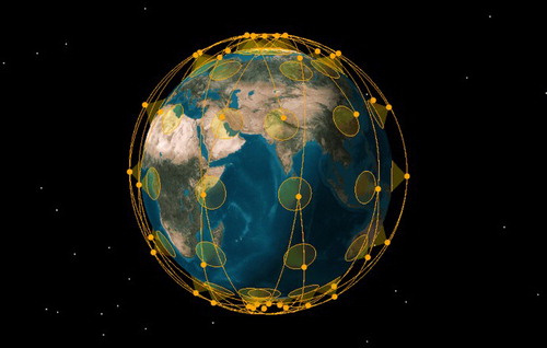
In line with the principles of ‘one satellite for multiple purposes, multi-satellite networking, and multiple network cooperation,’ a proposal for an integrated space-based real-time information service system was presented. The space-based network (), formed by a number (80–100) of low earth orbit (LEO) satellites with remote sensing, navigation, and communication functions, can be seamlessly integrated with existing ground-based Internet and mobile networks. In close coordination with the satellite navigation system, the following services can be achieved:
Global surface image and video data spatial resolution at the decimeter level;
Data acquisition temporal resolution at the hour level;
Real-time navigation and positioning services with precision finer than the meter level.
Figure 7. LEO constellation of the integrated space-based real-time information service system.
With the support of spatio-temporal big data, cloud computing, and intelligent terminals for space-based information services, all sectors of the national economy, industries, and the vast majority of public users will be provided with rapid, accurate, and intelligent PNTRC (positioning, navigation, timing, remote sensing, and communication) services in real time.
2.5. From sensing, recognition to cognition
To date, Geomatics has become fundamental in measuring, positioning, and target understanding, although it is lacking in spatial cognitive ability. In the big data era, through data processing, analysis, fusion, and mining, the spatio-temporal cognitive ability of Geomatics can be vastly improved. Spatial cognition is apparent in mankind’s social activities, such as urbanization, economic development, and military activity, based on multi-temporal remote sensing satellite data and data mining technologies.
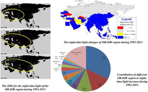
For example, through the development of temporal and spatial analysis and data mining technology, temporal series of night-time satellite images have been used to evaluate the updated progress of the Syrian civil war (Li and Li Citation2014). Furthermore, a case study shows that night-time light imagery is an efficient tool to demonstrate and analyze socioeconomic dynamics. ‘One Belt and One Road’ (OBAOR), which is short for ‘Silk Road Economic Belt and the 21st-Century Maritime Silk Road,’ is China’s state strategy for cooperation with Eurasian countries in the twenty-first century. The OBAOR involves more than 60 countries and 4 billion people, with differentiated political and socioeconomic systems, thus investigating the socioeconomic dynamics in these countries is a great challenge. A standard deviational ellipse (SDE) was chosen to analyze the spatial distribution pattern of night-time lights in the OBAOR region (). From 1993 to 2013, the focus of the night-time light in the OBAOR region moved 2060 km (100 km/year) from west to east, due to the rapid development of China, India, and Southeast Asia; the enlarged size of the ellipse shows the economy is more equally distributed in the OBAOR region; and the rotation of the ellipse indicates the increasing roles of China, Southeast Asia, and India, along with East Europe, which comprise a principal axis of the regional economy of the OBAOR region. Our analysis also shows that most of the OBAOR countries experienced a rapid increase in night-time light during 1993–2013. The night-time light in both China and Southeast Asia has increased quickly, showing rapid urbanization and economic growth in these countries. Dramatic increases in night-time light in some war-torn countries (e.g. Bosnia and Afghanistan) show that the peace processes and post-war reconstruction were effective. In contrast, night-time light decreased in some countries (e.g. Syria and Ukraine) due to economic decline and wars. Nowadays, daily night-time light images are accessible to global users; these images, along with daytime remote sensing data, will provide an efficient data source to monitor how these countries change every day, providing information for China’s OBAOR construction.
Figure 8. SDE for the night-time light in the OBAOR region during 1993–2013.
As another example, the location data, multimedia data, and digital map data continuously recorded in smartphones can provide insights into understanding the psychology of cellphone users, after effective processing, including context computing, fusion analysis, and data mining (Pei et al. Citation2013). Geomatics and spatial cognition can also contribute to brain cognition and artificial intelligence science.
With the advancement of sensors and improvement of information processing technology, Geomatics will take an increasingly important role in Geo-knowledge discovery, socioeconomic statistics and prediction, behavior perception, and other scientific research fields.
2.6. Crowdsourcing and volunteered geographic information
In the big data era, the development of ubiquitous non-dedicated spatio-temporal data sensors (e.g. smartphones) and online crowdsourcing platforms has facilitated the acquisition of volunteered geographic information (VGI) (Goodchild and Glennona Citation2010; Goodchild Citation2016). VGI reflects the ‘Value’ and ‘Veracity’ characteristics of big data. However, while it has high value for applications, its authenticity is difficult to distinguish.
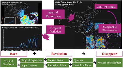
The considerable amount of VGI can enhance spatial and temporal information resources to create a scenario in which everyone is a geospatial information messenger. Particularly with the emergence of social media applications in recent years, it has become viable to study the evolution of social and natural events by mapping the relationship between social networks and the real world. Research on the interaction between social networks and the real world has provided strong theoretical and technical support for investigating public opinion and predicting the impact of unexpected events. Human and human-generated textual data streams from microblogging services are increasingly geo-referenced. For example, a study explored the space–time dynamics of Super Typhoon Soulik, which occurred in China during August 2013, in both virtual and physical space (see ). The topical content of millions of short textual messages in a stream was collected from China’s largest microblogging service, Sina Weibo.
Figure 9. Understanding the spatio-temporal spread and revolution of web hot events.
However, the non-professional characteristics of VGI often cause data noise, loss, inconsistency, and ambiguity, resulting in data uncertainty. Therefore, quality assurance procedures, such as data cleaning and quality inspection, are indispensable. Data cleaning includes discovery and removal of malicious content, detection and merging of duplicate data, and handling of confidential or private content; quality inspection includes correction and validation of data. In the first procedure, automated authentication and community auditing to identify malicious content, malicious removal pollution of data, and other illegal operations can be determined through analysis and mining of the user behavior model, where a high-dimensional clustering of VGI data is commonly used to detect the redundancy. In validation inspection processing, the validity of the geometry and attribute information is checked by its consistency between different data sources and inner constraints in geometry and attribute. Of course, it will be beneficial if more intelligent online software and development tools can be designed and easily accessed by users (Goodchild and Li Citation2012).
2.7. Service-oriented science
Such smart service differs from traditional data-driven ones in both its production and distribution processes, as it requires on-demand aggregation of resources and efficient collaboration of services in a service-focused information framework.
Traditional geospatial information service models, which are usually built towards a given type of sensor or data for one specific professional application, do not have the capacity for integrating multiple source types, including sensor sources, processing sources, and data /information/knowledge sources distributed in different locations to meet personalized, customized service demands in the big data era. In a distributed networked environment, it is necessary to cooperate with the sensor resources, data resources, and computing resources and optimize the flow of information service according to the mission requirements, in order to meet the diversified needs of users. In a service-focused information framework (see ), all of the above resource types are registered as nodes in a registration center through a series of standard interfaces. According to the task demands of users in different application fields, the service engine can automatically build a service chain by aggregating resources, providing services such as sensor planning and scheduling, heterogeneous observational data acquisition, and online data processing. In addition, the service-focused geospatial information framework provides a visualized environment for service chain optimization and service quality evaluation.
Figure 10. Service-focused geospatial information framework.
The geospatial information service framework provides a seamless connection of multi-sensor observation, multi-source heterogeneous data processing, information extraction, and even decision-making, to lay a solid technical foundation for event intelligence perception, cooperative observation, data assimilation, and intelligent processes. Nowadays, researchers are encouraged to develop information service network modeling and scheduling methods to provide users with smart services instead of data products.
3. Challenges for Geomatics in the big data era
The above characteristics of Geomatics in the big data era show that Geomatics must capitalize on the development opportunities embraced by big data to meet the challenges posed by the new demands. Some key technical challenges for smart geospatial information services are summarized below (Li et al. Citation2014).
3.1. Establishment and maintenance of terrestrial spatial datum considering non-linear variation
A precise and unique spatial datum system provides the foundation for geospatial data processing and information services. The ideal implementation of the spatial datum system is the terrestrial reference frame (TRF), which consists of a series of fixed reference stations on the surface of the earth that are expressed as the coordinates and velocity fields of these reference stations at an epoch. At present, the TRF usually only considers the linear velocities of these reference stations (Song, Zhu, and Xiong Citation2009). In fact, the motion of a reference station includes both linear and non-linear components. A reference frame that only considers the linear velocity of the reference station gives only centimeter-precision. In the big data era, Geomatics should provide a precise TRF to massive data derived from ubiquitous sensors for subsequent processing and analysis. Technologies for establishment and maintenance of a TRF considering non-linear variation should be developed. By combining the data from various high earth orbit, medium earth orbit, and LEO satellites, with the observation data from the static ground tracking station, non-linear TRF works can be developed and maintained. Three problems still remain to be addressed in order to construct this framework:
Theories and methods to establish a global unified epoch TRF work based on comprehensive multi-source observation techniques;
Analysis of time-varying characteristics of earth structural and non-structural influencing factors involved in a non-linear TRF work;
Theoretical methods and implementation techniques for non-linear motion prediction models of a global dynamic terrestrial framework.
3.2. Space-based global navigation satellite system augmentation
High-precision real-time navigation and positioning has always been an important issue for Geomatics. Nowadays, the direct real-time accuracy of the Global Positioning System is approximately 5 m. Many ground-based Continuously Operating Reference Stations (CORS) have been constructed to improve the real-time positioning accuracy to semi-meter level in recent years. However, it is very difficult to construct CORS in many parts of the world, especially in mountainous and oceanic areas. This means that global real-time precise LBS is not yet available. Using continuous records from on-board global navigation satellite system (GNSS) receivers equipped on LEO satellites, in combination with an existing ground-based augmentation system, the global real-time positioning precision of the existing satellite navigation system could be improved. However, the following problems must be solved:
Correction of the navigation satellite’s ephemeris and clock errors based on observations of LEO satellites;
Precision of the single-point positioning technique in combination with signals from LEO satellites/navigation satellites;
Combined orbit determination algorithms for LEO and navigation satellites;
Combined adjustment of inter-satellite laser ranging and navigation data;
Optimal design of the LEO navigation constellation.
3.3. Space–air–ground integrated transmission of Geomatics data
At present, spatial information services are mainly targeted at professional users; data transmission is mainly dependent on the ground-based network. In the big data era, with the improvement of communication networks and rapid growth of intelligent terminals, Geomatic services will expand to non-professional users, by directly delivering interested information to them via an integrated space–air–ground network to meet their timeline requirements. Integrated space–air–ground transmission of Geomatics data will be an increasingly important challenge in the future. To meet the requirements of massive multi-source geospatial data transmission, an integrated communication network must be constructed through the interconnection of space- and ground-based networks.
Furthermore, due to the open nature of space-borne networks, inter-satellite or satellite–ground communication links are vulnerable to interference or even serious damage due to cosmic rays and electromagnetic signals. The main technical issues include the following:
Wide area coverage of the multi-layer space-based network;
Service-driven space communication and on-demand access;
Fusion and interconnection of space- and ground-based networks and seamless switching between them;
Automatic network routing in highly dynamic circumstances;
Space-borne network reliability theory and network security system architecture;
Space-borne network anti-damage, secure routing, and network self-healing techniques
3.4. In-orbit processing of multi-source satellite imaging data
At present, satellite data are processed into various levels of standardized product at ground-based stations. In the big data era, in order to meet the user’s personalized and real-time requirements, it is necessary to implement a satellite–ground cooperative data processing mode according to the task requirements. Therefore, some data processing functions should migrate from ground-based station to satellite, and multi-source data in-orbit processing will become an urgent issue. Through satellite-to-ground resource coordination and optimization targeted at massive satellite images and video data, given the limited on-board storage, processing, and transmission capacity, the information extraction efficiency and automation level need to be upgraded. To this end, research must be conducted regarding the following aspects:
Real-time geometric correction of satellite image (video) data;
In-orbit detection of typical image objectives;
Typical (moving) target extraction algorithms for satellite video data;
In-orbit intelligent data compression of image (video) data;
General on-board image data processing platform, architecture, and software.
3.5. Intelligent information service technique suitable for smart mobile terminal
In addition to providing services to professional users, geospatial information services will encompass customized intelligent services for public users in the big data era. Accordingly, it is necessary to develop an information service technique suitable for smart mobile terminals, such as smartphones, which have become the mainstream information service platforms. Compared to the demands of spatial information services in the big data era, current mainstream mobile terminals and apps have the following shortcomings: (1) The majority of mobile phones have no direct access to satellite communication networks, so they cannot receive image (video) information obtained by satellites in a timely manner; (2) Customer-level mobile phones cannot receive GNSS augmentation signals broadcast by ground-based CORS, with the result that high-precision real-time positioning and navigation still cannot be achieved; and (3) Application software is mainly based on archived data stored in servers, and LBS apps have not made use of real-time observation data.
In order to receive accurate real-time geospatial services, including LBS based on real-time remote sensing, video, and navigation augmentation data, communication and data transmission services based on integrated space–ground networks, more highly integrated communication/navigation chips, and real-time data-based mobile apps will need to be developed. Relevant research should focus on the following key technologies:
LBS technologies oriented towards integrated satellite–ground networks;
Multi-mode positioning techniques for mobile terminals;
Manufacturing of space-based augmented navigation chips and core elements in mobile terminals;
Consumer-grade satellite communication terminals (such as a mobile phone satellite communication shell);
Mobile apps based on satellite–ground communication networks.
3.6. Multi-platform sensor observation mission scheduling
Ubiquitous sensor networks have allowed people to observe more events according to user demand by utilizing polytype sensors, such as satellites, airplanes, UAVs, or even webcams. For one specific observation task, we need to scientifically configure the sensor resources according to the position, shape, size, timeliness, spatial resolution, and imaging mode (visible light or SAR; image or video) of the observation task, and scientifically arrange the observation action sequence of each sensor. However, due to the different imaging capabilities and imaging constraints of various sensors, it is necessary to study the multi-platform sensor collaborative observation task optimization method to meet the user’s requirements at maximum capacity. The following initiatives must be addressed:
Geo-sensor resource organization model and solution algorithm under complex multiple task conditions;
Rapid resource reorganizing method considering task or resource changes;
Simulation and evaluation of dynamic satellite mission planning.
In our opinion, Geomatics researchers must take advantage of new research achievements in related disciplines and interdisciplinary collaborative innovation to meet the aforementioned challenges.
4. Towards Geomatics in the big data era
The International Organization for Standardization (ISO) defined Geomatics as:
a field of activity which, using a systematic approach, integrates all the means used to acquire and manage spatial data required as part of scientific, administrative, legal, and technical operations involved in the process of production and management of spatial information. These activities include, but are not limited to, cartography, control surveying, digital mapping, geodesy, geographic information systems, hydrography, land information management, land surveying, mining surveying, photogrammetry, and remote sensing.
In addition, the ISO gave the following similar yet simpler definition: ‘Geomatics is the modern scientific term referring to the integrated approach of measurement, analysis, management, and display of spatial data.’ Based on the above definitions, Geomatics emphasizes spatial data collection, measurement, analysis, and display of the earth and physical objects by using various observation means for the purposes of extracting, managing, and applying spatial information.
Geomatics is a service-oriented science. The ultimate goal of geospatial information services is to deliver the Right data, information, or knowledge to the Right person in the Right place at the Right time, which we term the ‘4R’ service. With the advent of the big data era, Geomatics will usher in a historic opportunity to achieve this goal for the first time.
In the big data era, Geomatics involves the above-mentioned seven characteristics. To achieve accurate, fast, and customized ‘4R’ services, Geomatics is still facing six major challenges: (1) Establishment and maintenance of a high-precision spatial datum; (2) Global real-time positioning and navigation; (3) Fast and secure transmission of Geomatics data via space–air–ground networks; (4) In-orbit processing of multi-source satellite imaging data; (5) Cooperative observation of multi-platform sensor networks; and (6) Smart information services adapted for mobile terminals.
Therefore, we should provide a definition of Geomatics in line with these characteristics: Geomatics is a multi-disciplinary science and technology that uses systematic approaches to integrate all the means for task-oriented spatio-temporal data acquisition, information extraction, network management, knowledge discovery, and spatial sensing and recognition, as well as intelligent LBSs pertaining to any physical objects and human activities on the earth. The research content of Geomatics will encompass the whole process of the geo-information service, starting from understanding user’s demand represented in natural language, seeking appropriate data sources, selecting processing tools or software for information and knowledge extraction, forming reasonable service chains, and finally, delivering useful information and knowledge to the user’s intelligent terminal, as well as key supporting technologies including spatial datum construction and spatial data transmission.
Starting from this definition, Geomatics will embrace more development opportunities and face more challenging tasks for building smart earth and smart cities in the big data era. Geomatics will surely contribute to the sustainable development of human society.
Disclosure statement
No potential conflict of interest was reported by the authors.
Additional information
Funding
References
- Bedard, Yvan. 2014. “Beyond GIS: Spatial On-Line Analytical Processing and Big Data.” September 18. http://www.spatial.ucsb.edu/docs/2014-Dangermond-Lecture.php.
- Cha, Sangwhan, Marta Padilla Ruiz, Monica Wachowicz, Loc Hoang Tran, Hung Cao, and Ikechukwu Maduako. 2016. “The Role of an IoT Platform in the Design of Real-time Recommender Systems.” Paper presented at IEEE 3rd World Forum on Internet of Things (WF-IoT), Reston, December 12–14.
- Craglia, Max, Kees de Bie, Davina Jackson, Martino Pesaresi, Gábor Remetey-Fülöpp, Changlin Wang, Alessandro Annoni, et al. 2012. “Digital Earth 2020: Towards the Vision for the Next Decade.” International Journal of Digital Earth 5 (1): 4–21. doi:10.1080/17538947.2011.638500.
- Evans, Michael R., Dev Oliver, Xun Zhou, and Shekhar Shashi. 2014. “Spatial Big Data: Case Studies on Volume, Velocity, and Variety.” In Big Data: Techniques and Technologies in Geoinformatics, edited by Hassan A. Karimi, 149–176. New York: CRC Press.
- Gong, Jianya, Jing Chen, Longgang Xiang, Hanjiang Xiong, Huayi Wu, and Yandong Wang. 2010. “GeoGlobe: Geo-spatial Information Sharing Platform as Open Virtual Earth.” Acta Geodaetica et Cartographica Sinica 39 (6): 551–553.
- Gong, Jianya, Xiaolong Li, and Huayi Wu. 2014. “Spatiotemporal Data Model for Real-time GIS.” Acta Geodaetica et Cartographica Sinica 43 (3): 226–232. doi:10.13485/j.cnki.11G2089.2014.0033.
- Goodchild, F. Michael. 2016. “GIS in the Era of Big Data.” European Journal of Geography. http://cybergeo.revues.org/27647.
- Goodchild, F. Michael, and L. Alan Glennona. 2010. “Crowdsourcing Geographic Information for Disaster Response: A Research Frontier.” International Journal of Digital Earth 3 (3): 231–241. doi:10.1080/17538941003759255.
- Goodchild, F. Michael, and Linna Li. 2012. “Assuring the Quality of Volunteered Geographic Information.” Spatial Statistics 1: 110–120. doi:10.1016/j.spasta.2012.03.002.
- Gore, A. L. 1998. “The Digital Earth: Understand Our Planet in 21st Century.” Australian Surveyor 43 (2): 89–91. doi:10.1080/00050348.1998.10558728.
- Howe, Doug, Maria Costanzo, Petra Fey, Takashi Gojobori, Linda Hannick, Winston Hide, David P. Hill, et al. 2008. “Big Data: The Future of Biocuration.” Natrue 455: 47–50. doi:10.1038/455047a.
- Jeansoulin, Robert. 2016. “Review of Forty Years of Technological Changes in Geomatics Toward the Big Data Paradigm.” ISPRS International Journal of Geo-Information 5 (9): 155. doi:10.3390/ijgi5090155.
- Li, Deren. 2012. “On Space-Air-Ground Integrated Earth Observation Network.” Journal of Geo-Information Science 14 (8): 412–415.
- Li, Xi, and Deren Li. 2014. “Can Night-Time Light Images Play a Role in Evaluating the Syrian Crisis?” International Journal of Remote Sensing 35 (18): 6648–6661. doi:10.1080/01431161.2014.971469.
- Li, Deren, Xin Shen, Jianya Gong, Jun Zhang, and Jianhua Lu. 2014. “On Construction of China’s Space Information Network.” Geomatics and Information Science of Wuhan University 40 (6): 711–715. doi:10.13203/j.whugis20150021.
- Li, Deren, Shuliang Wang, and Deyi Li. 2015. Spatial Data Mining: Theory and Application. Berlin: Springer.
- Li, Deren, Liangpei Zhang, and Guizong Xia. 2014. “Automatic Analysis and Mining of Remote Sensing Big Data.” Acta Geodaetica et Cartographica Sinica 43 (12): 1211–1216. doi:10.13485/j.cnki.11-2089.2014.0187.
- Manfred, Ehlers, Peter Woodgate, Alessandro Annoni, and Sven Schade. 2014. “Advancing Digital Earth: Beyond the Next Generation.” International Journal of Digital Earth 7: 13–16. doi:10.1080/17538947.2013.814449.
- Pei, Ling, Robert Guinness, Ruizhi Chen, Jingbin Liu, Heidi Kuusniemi, Yuwei Chen, Liang Chen, et al. 2013. “Human Behavior Cognition Using Smartphone Sensors.” Sensor 13 (2): 1402–1424. doi:10.3390/s130201402.
- Reichman, O. J., M. B. Jones, and M. P. Schildauer. 2011. “Challenges and Opportunities of Open Data in Ecology.” Science 331 (6018): 703–705. doi:10.1126/science.1197962.
- Shan, Jie, Kun Qin, Changqing Huang, Xiangyun Hu, Yang Yu, Qingwu Hu, Zhiyong Lin, et al. 2014. “Methods of Crowd Sourcing Geographic Data Processing and Analysis.” Geomatics and Information Science of Wuhan University 39 (4): 390–396. doi:10.13203/j.whugis20130633.
- Song, Shuli, Wenyao Zhu, and Fuwen Xiong. 2009. “Construction of Mm-Level Terrestrial Reference Frame.” Chinese Journal of Geophysics 52 (11): 2704–2711. doi:10.3969/j.issn.0001-5733.2009.11.004.
- Yang, Bo. 2016. “Accuracy Validation of Large-scale Block Adjustment without Control of ZY3 Images over China.” Paper presented XXIII ISPRS Congress, Prague, Czech Republic, July 12–19.