
ABSTRACT
Virtual geographical environments (VGEs) are being used to represent our sense of place through the application of extended-reality or cross-reality (XR) technologies with a focus on technological advancement and immersion. In light of this, we propose that an expanded and interdisciplinary understanding of the concept of immersion is required to facilitate an understanding of spatial data to a broader audience. The potential of focusing on narrative immersion and literary placemaking in VGEs is discussed to evoke a stronger sense of place and a feeling of presence and belonging in users. This paper seeks to highlight the unique affordances and potentialities of XR narrative style GIS digital representations through an interdisciplinary theoretically lead analysis of outputs created by the Building City dashboards project towards the goal of expanding audiences of non-specialist stakeholders in urban planning processes.
1. Introduction
Virtual geographic environments have attracted the attention of researchers from various fields for more than two decades (Chen et al. Citation2017). They were defined by Lin and Gong (Citation2001) as ‘environments pertaining to the relationship between post-humans and 3-D virtual worlds’. The concept of merging geographic data and virtual environments can also be connected to the work of MacEachren et al. (Citation1999), where it was named geospatial VE (GeoVE) and imagined as a tool for producing ‘super environments’ that would allow users to experience things that are not visible and beyond control in the real world. This focus on user experiences is also visible in Lin and Batty’s (Citation2009) working definition of VGE, which highlights the deep embedding of the user that is not typical for the standard deliverables and uses of GIS. Lin et al. (Citation2013) propose further positioning VGEs as the next step of geographical analysis, beyond the maps and GIS systems, that will overcome some of their deficits in providing geographical knowledge. In this sense, VGEs are built for geographic understanding and problem-solving tasks by aiming to virtually augment users’ senses and allow for almost first-hand experience through simulations and collaborative experiments (Lin et al. Citation2013, Chen et al. Citation2017). While contemporary VGEs employ many technological functions that include multi-channel human–computer interactions (HCIs), distributed modelling, simulations, and collaboration, it is still the geographic environment that plays a central role (Chen and Lin Citation2018), and its understanding by the user is the main purpose of their creation.
In search for appropriate visualisation and display methods for VGEs, the attention has been on immersive technologies from the extended reality (XR) spectrum (Çöltekin et al. Citation2020), especially virtual reality (VR), that were seen as promising interfaces for 3D visualisations and collaborations (Lin and Gong Citation2001; Chen and Lin Citation2018). This attention followed a period of heightened interest in VR within the GIS community (Haklay, Fischer, and Unwin Citation2002). The use of VR in geospatial application continued to be investigated, mainly in the field of VGE (Huang and Lin Citation1999; Lin et al. Citation2013; Voinov et al. Citation2018), as it can be seen as beneficial to visualise multi-scale and multi-dimensional geographic phenomena (Havenith, Cerfontaine, and Mreyen Citation2019; Li, Zhu, Fu, Zhu, Guo, et al. Citation2021).
From a VGE design and development perspective, XR-based virtual environments have several advantages – from allowing natural depth perception to intuitive hand-based interactions. Also, the availability of modern game engines like Unity 3D or Unreal makes it much easier to design 3D virtual worlds (Keil et al. Citation2021). However, the primary affordance of XR, and VR in particular, is the ability to induce immersion. It is generally assumed that immersion and the feeling of presence within virtual environments can induce an emotional response from the viewer/user and that this, in turn, can help with absorbing spatial information (Hruby et al. Citation2020; Winn et al. Citation2002), supporting the experience that more closely resembles a ‘real’ environment. In defining geovisualised immersive virtual environments (GeoIVE) Hruby and co-authors (Hruby, Ressl, and del Valle Citation2019) generalised that realistic representation at a 1:1 scale is necessary. However, as stated earlier, this paper argues that immersion is one of the most essential features of VGE that needs to be more deeply discussed, particularly with an interdisciplinary approach. Immersion and presence, while often used interchangeably, are not the same (Evans and Rzeszewski Citation2020) and there are different processes that can lead to achieving them by the user. While in the field of GIS, we often assume that better technological tools are all we need to improve immersion (Slater et al. Citation1996) and, in turn, induce presence, it is also true that there are many existing methods that achieve the same goal within the field of arts and humanities. Technologically oriented works of art such as VR and AR installations rely on what can be called a humanistic sense of place to evoke, more effectively, in the viewer/user feelings of presence and belonging. A narrative style approach in XR visualisations compared to the high-fidelity digital twin mirror worlds historically found in VGEs engages with the semiotic space of virtual environments similarly to literary texts. A mirror world involves integrating multiple forms of technology such as mixed reality smart spaces and the Internet of Things. Mirror worlds occur when analogue or physical objects have a digital counterparts or digital twins that can be engaged and acted upon by humans such as can be found in XR (Ricci et al. Citation2015, 60–63). Ricci, Tummolini, and Castelfranchi (Citation2019) outline that mirror worlds are useful as conceptual models that indicate likely future trends of augmented societies. However, without the capacity to provide an immersive, engaging experience the potential efficacy of the environment is diminished. Therefore, immersion is not necessarily brought about by fidelity to the analogue twin, but rather in the capacity for an affective or evocative connection with the user allowing them to fully engage in the virtual environment. This is the concept that we think is worth exploring further within the VGE discourse and practice.
The main aim of this paper is to examine humanistic sense-of-place approaches in the design of VGE as a non-technical tool for increasing immersion, thereby offering the opportunity for an increased non-specialist audience engagement in urban planning processes. The urban planning domain has been chosen because it often involves VGEs that are constructed to facilitate spatial understanding and to be used by a broader public. The usefulness of VGEs in this respect has already been acknowledged by city planners (Kitchin, Coletta, and McArdle Citation2020). Still, the discussion we present here is valid for a wide range of domains. This paper focuses on the virtual environments constructed using VR modes of display, but the proposed approach can also be adopted in other 2D and 3D displays. Similarly, we use examples that are based on text, which is recognised in cartographic tradition as a tool that can convey meaning beyond the information carried by symbols alone (Kraak Citation1999), but it is but one of the tools in narrative placemaking. We construct our discussion by taking a closer look at the current relationship between VGEs, XR technology and urban planning, and reviewing the rich field of relevant concepts of immersion and presence. We then proceed to introduce the humanistic concepts of narrative immersion and literary placemaking through a discussion of a case study, The Data City (BCD Citation2021). We conclude by analysing the potential of this method for VGE in urban planning and present an outline of a research agenda.
2. VGE and XR in urban planning
VGEs are well suited for planning purposes (Lin and Gong Citation2001) and Chen and Lin (Citation2018) identified ‘predicted and planned future geographic environments’ as one of the three main types of VGEs. Virtual environments bring to urban planning several advantages. Firstly, they provide a framework for integration, modelling and visualisation of many different layers of data from simulation of human behaviour (Mekni Citation2018; Shen et al. Citation2018), through environmental hazards (Li, Zhu, Zhu, Guo, et al. Citation2021; Yu et al. Citation2021), water polution (Rink et al. Citation2018) to whole urban ecology (Ma et al. Citation2020). Secondly, they can position stakeholders of planning processes in the common geographical frame of reference with familiar scenarios and clear access to information (Li, Zhu, Fu, Zhu, Xie, et al. Citation2021). This is valid for both participating experts and a wider public (Lin et al. Citation2013) and allows the possibility of social factors being incorporated into decision-making processes (Goodchild Citation2009; Mania et al. Citation2010). Improving collaboration can be seen as a good solution to mitigate some of the common deficits of public participation in urban planning (Howard and Gaborit Citation2007) as VGEs can foster mutual communication (Ball, Capanni, and Watt Citation2007). Another important factor is emotional engagement. Realistic VGEs can bring into collaborative planning emotional aspects of engagement (Koutsabasis et al. Citation2012; Coltekin, Lokka, and Boér Citation2015) that are even more pronounced when VR is employed as a display technology instead of a screen (Jiang, Maffei, and Masullo Citation2016; Meenar and Kitson Citation2020). XR has been seen for a long time as a promising avenue of evolution within the field of urban planning (Kamel Boulos et al. Citation2017; Batty Citation2008) and the slow but steady technological advance allowed for renewed interest and successful implementations. Examples of XR use in VGE such as flood dynamic visualisation with AR and printed models (Zhang et al. Citation2020), debris flow representation with AR (Li, Zhu, Fu, Zhu, Xie, et al. Citation2021), or a large-scale disaster visualisation with mobile VR (Zhang et al. Citation2022), show how the perception of the environment can be improved through technology. While visualising of socio-environmental models with XR and VGE needs to be properly designed to be beneficial (Voinov et al. Citation2018), the potential rewards are promising. From a practical point of view, XR often overlaps with the concept of VGE (Chen et al. Citation2017) and is sometimes used interchangeably. VGE is however, a much wider theoretical framework – not all VGEs are created using XR technology and not all XR solutions can be considered VGE, as they are often focused mainly on visualisations. However, there are many examples of XR and VGE concepts being successfully applied for management and planning of cities. They can be employed toaccess places that cannot be reached in material space (Portman, Natapov, and Fisher-Gewirtzman Citation2015) and interact with objects that only existing as planned possibilities (Cirulis and Brigmanis Citation2013). They excel as multisensory community planning platforms (van Leeuwen et al. Citation2018). In Canberra VR based Esri City Engine has been used to visualise the effects of light rail development (Schubert Citation2017) and recently in London’s Square Mile new planning proposals can utilise detailed digital twin model of Square Mile to gauge the potential changes (VU.CITY Citation2021). In almost all of the above examples the immersion and presence induced via the use of VGEs and VR plays a prominent role as an affordance of the medium, even when this is not explicitly stated. In the next section we look at immersion and presence and their role in mediating spatial experiences.
3. Immersiveness and presence in virtual environments
Immersion is the most frequently used term to describe the experience desired by the creators of virtual environments (Konecny Citation2011; Keil et al. Citation2021) and virtual reality in general (Evans Citation2018; Slater Citation2018). This includes VGEs and while here we are focusing on immersive-VGEs constructed using XR technology, it is worth mentioning some of the types of immersion (see below) that are applicable to non-immersive environments. In literature related to VGE immersion as a concept is either included explicitly like in MacEachren et al. (Citation1999) as one of the 4 I’s and ‘human immersion’ in the work of Chen et al. (Citation2017) or even more commonly non-directly, by references to users being able to ‘feel it in person’ (Lin et al. Citation2013), ‘naturally experience virtual scene’ (Lü et al. Citation2018) or being ‘deeply embedded’ (Lin and Batty Citation2009). Closely associated with immersion is presence, which we think in the context of VGEs can be even more important as it is a prerequisite for generating the sense of place. The main difference between immersion and presence is that the latter is seen as a subjective, psychological experience, and the former is a function of the technology that is being used in a given implementation (Nilsson, Nordahl, and Serafin Citation2016). Immersion is a nebulous term, but it seems that within the fields of VGE research and development it is most closely associated with the technological fidelity of the system. Slater (Citation2003) defined this kind of immersion as ‘technological feature, measure of the capability of a given system to replace physical space with virtual environment’ and we will use the term ‘system immersion’ (Slater Citation1999) as a reference for this. Within this point of view immersive system can in turn generate the feeling of presence in the user. Presence is often seen as a shortened version of ‘telepresence’, a term that was coined by Minsky (Citation1980) to describe the sensation of ‘being there’ in some remote location. It has been associated with virtual environments since the realisation that this remote location can be entirely virtual (Sheridan Citation1992; Berkman and Akan Citation2019). International Society for Presence Research define presence as:
Presence (a shortened version of the term “telepresence”) is a psychological state or subjective perception in which even though part or all of an individual’s current experience is generated by and/or filtered through human-made technology, part or all of the individual’s perception fails to accurately acknowledge the role of the technology in the experience. (ISPR Citation2000)
Perhaps the most interesting perspective of presence regarding VGEs is given by Slater and his co-authors (Slater et al. Citation2009). They describe it as a phenomena that manifests itself when a person responds to virtual stimuli in a similar way as they would to unmediated ones. Slater (Citation2009) also proposes that this illusion is created by the simultaneous occurrence of two perceptual illusions: place illusion and plausibility illusion. The first one creates the feeling of being in another place when a person can be otherwise sure that this is not the case and the second one is that the situation a person is in is real, despite the knowledge that it is entirely fictional. The illusion of place is also mentioned in the conceptualisation of presence given by Biocca and co-authors, of a ‘phenomenal sense of “being there” including automatic responses to spatial cues and the mental models of mediated spaces that create the illusion of place’ (Biocca, Harms, and Burgoon Citation2003).
We think that the ability to induce this sense of presence and illusion of place is one of the features, which when implemented properly within VGE design can greatly increase its usefulness. Chen and Lin (Citation2018) observe that while XR can provide more realistic and natural environments, it still needs to adhere to geographic laws, rules, and knowledge to be considered a digital geographic environment. We agree with that observation and add to this the notion that to naturally experience VGE in a fashion similar to material environment, we also need to provide for the user the ability to experience an affective sense of place. Participatory members of the public or smart-citizens may not be able to accurately read a graph and identify meaning from the contents of a VGE. So, to find other ways to engage citizens in VGEs and incur and greater engagement of spatial understanding the VGE must explore all aspects of immersion to induce the feeling of spatial presence and affective sense of place. Only then, when there is a possibility of forming an emotional response to space that is meaningful and embodied, a sense of place can be formed as a natural way people perceive their spatial relation and affective connection to their environment.
How exactly to provide such experience in practice is another question that we think requires more attention. The notion that further technological development can improve immersion and in turn provide an increased feeling of presence is often assumed, especially when it means adding XR display capabilities to a system (Slater et al. Citation1996; Edler et al. Citation2018). While there is some research that confirms that XR based virtual environments with higher levels of system immersion can provide increased presence in comparison to a low-immersive visualisations (Hruby et al. Citation2020), there are also studies that shows that this effect is at best medium sized (Cummings and Bailenson Citation2016). However, system immersion is not the only type of immersion. It has been shown that analogue media can provide spatial presence through mechanisms other than system immersion (Schubert and Crusius Citation2002) and immersion itself can be seen as a subjective experience in a somewhat similar fashion to presence. One of the more widely known such conceptualizations is the Witmer and Singer (Citation1998) definition of immersion as a ‘psychological state characterized by perceiving oneself to be enveloped by, included in, and interacting with an environment that provides a continuous stream of stimuli and experiences’. This state can be the result of using technology such as XR but may be as well caused by narratives and stories. Adams and Rollings (Citation2006) provided a term ‘narrative immersion’ to describe this phenomena: ‘the feeling of being inside a story, completely involved and accepting the world and events of the story as real’. The narrative depictions of locations and scenery bring what Ryan called (Citation2001) a spatial immersion. This feeling is akin to having a sense of place and emotional response for virtual scenery (Ryan Citation2001). In game environments and similar situations where users have a task before them to complete, immersion can be also caused by the focused attention toward achieving this goal. Ermi and Mäyrä (Citation2007) propose that this kind of immersion is ‘at its most powerful when one is able to achieve a satisfying balance of challenges and abilities’. This is also similar to the concept of flow used to describe the experience of gaming in general (Csikszentmihalyi Citation1990). However, the connection between flow and spatial presence has been debated (Weibel and Wissmath Citation2011).
Nilsson, Nordahl, and Serafin (Citation2016) have proposed an elegant taxonomy of existing conceptualizations of immersion that is constructed with three axes: system immersion, narrative immersion, and challenge-based immersion, that represent factors in creating presence. Within this three-dimensional space the feeling of presence can be placed in one of more areas, depending on the importance of the factors involved in its creation. This importance varies according to the preferred theoretical model, perceptual capabilities and mental state of the user and other external factors. What is however important in regard to the VGE development it is clear to see that it would be beneficial to include other kinds of immersion beside the system immersion. Narrative immersion in particular is a promising avenue of research in this direction as it can be applied to a wide range of uses within VGE applications.
4. Narrative immersion & literary placemaking
Narrative immersion and the placemaking potential it brings both rely on various understandings of human spatiality. Ryan, Foote, and Azaryahu (Citation2016, 6) note that the science and humanities use the terms of space, place and ‘sense of place’ in a number of ways. These terms are central to the work of geographers but also to writers and virtual reality developers. In 2015, narrative theorist Marie-Laure Ryan alludes to the human geographer Yi-Fu Tuan’s celebrated concepts of both space and place as contrasting entities. Ryan explains that space is abstract, whereas place concerns itself with a ‘concrete environment invested with emotional value’ (Ryan Citation2015, 87–89). Similarly, interaction design researchers Harrison and Dourish (Citation1996) choose to further differentiate between human concepts of space and place. Space, they suggest, relates to the structure of the world, the three-dimensional environment in which we inhabit. However, in their theory of place, they contrast cultural understandings with those which frame innate human-behaviour (Naji, Young, and Stehle Citation2018, 3). Furthermore, given the expanded space dimensionality in virtual environments movement can now be used as a social language (Murray Citation2017, 184). In fact, Janet Murray proposes that for genres beyond narrative, we can identify four affordances – the procedural, the participatory, the encyclopaedic, and the spatial – that together support new forms of interactivity and immersion (Jenkins, Lashley, and Creech Citation2017, 1068).
Mundell (Citation2018) explores literary placemaking through the eyes of the creator, she believes that creative writers face a unique challenge in that they must ‘imaginatively evoke textual place in a way that resonates meaningfully for a diversity of readers’. Mundell talks of how ‘places and stories are innately entwined’ and her paper ‘Crafting “Literary Sense of Place”: The Generative Work of Literary Place-Making’ offers a model of ‘place-oriented experiential techniques’ (POET) that lists five modes: Retrospective techniques, Immersive techniques, Collaborative Techniques, Vicarious techniques and Nebulous techniques. These modes, Mundell argues can be used to demystify and theorise the process of literary place making. Meg Mundell (Citation2018, 10) explains that creative writing is a literary form of place making. Could then these same techniques be applied to a kind of ‘virtual placemaking’ based on real geographical space such as those digital landscapes that can be found in VGEs? It is notable too that Mundell lists immersive techniques are being a prime component of literary placemaking in a similar fashion to virtual placemaking.
Immersive techniques (being present/encountering place: using direct encounters with place): site visits offer writers an immediate sensory and emotional engagement with place. Planned site visits and photography are central to Birch’s practice, but happenstance and serendipitous place encounters can also yield creative dividends (Mundell Citation2018, 10).
5. Case study of Data City
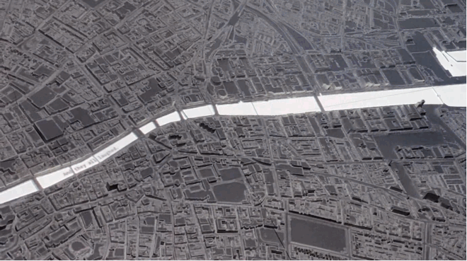
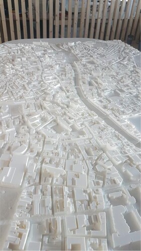
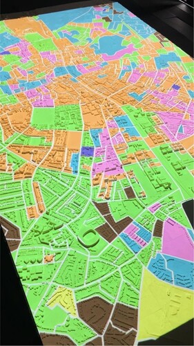
Data City (BCD Citation2021) is a digital exhibition and interactive installation output from the Building City Dashboards (BCD) research project,Footnote1 that features a variety of digital city data dashboard technologies and solutions that include data visualisations projected onto 3D printed scale models of Dublin and Cork cities (). The Data City (BCD Citation2021) interactive installation component is an example of a spatially augmented reality (Bimber and Raskar Citation2011) that uses projection mapping process. The model’s physical dimension are 3.5 × 2 m in which yield an accurate topographical representation of 28 sq km of urban area at a scale of 1:2000, yielding a representation of 28 sq km of terrain in each model. The installation can be used to show air quality and noise levels, building use classifications, geodemographic analyses, AirBnB properties, historic maps, the Urban Atlas maps of urban land use and a simulation of Luas tram movements (BCD, Online) (). The public exhibition was due to be staged in the summer of 2020 but due to Coronavirus pandemic lockdowns it was instead staged privately and locally on campus in Maynooth University and documented and transferred online to the project’s web site at https://dashboards.maynoothuniversity.ie/exhibition/.
Figure 1. 3D printed model of Dublin City created by the BCD project.
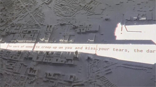
Figure 2. Open data visualisations projected onto 3D printed model of Dublin City (BCD Citation2021).
In Data City (BCD Citation2021) the user can examine a rigorously designed and developed 3d printed model of Dublin city developed by an interdisciplinary team of Geographers and Media Studies researchers. The River Poem (Naji, Freeman, and Linnane Citation2019) is a kinetic text piece that makes up part of the Data City exhibition and installation and is a useful example to discuss in more detail as it incorporates some of the concepts that were introduced above. It is an example of a digital text that is spatially situated in the same way that urban planning VGEs are but also incorporates some aspects of literary placemaking and multimodal communicative dimensions as can be found in the field of digital multimedia in the form of kinetic text and atmospheric audio. The River Poem is a digital poem made by Jeneen Naji, Pauric Freeman and Mark Linnane made in collaboration with the BCD project. This digital piece projects snippets of text generated by the Generative Pretrained Transformer 2 machine learning algorithm onto a 3D model of Dublin City (). The words themselves were generated by a GPT-2 machine learning algorithm that was trained on James Joyce’s Finnegan’s Wake.
Figure 3. The River Poem is a projected AR installation that merges narrative – based immersion with 3D models and data visualisation (Jeneen Naji, Building City Dashboards).
The River Poem intends to offer audiences an alternative approach to viewing the city by projecting words onto the Building City Dashboard’s 3D model. The Building City Dashboards research project sought to determine how to build more extensive and effective city dashboards by extending data visualisation tools and investigating novel forms of multimedia interaction, including the projection of data onto architectural models, and converting data into audio-textual forms. Snippets of phrases were removed from the algorithm’s output by the human authors and then placed in a spreadsheet. Python code in TouchDesigner software then randomly selects a new quote from the spreadsheet at specific intervals and places it into a queue. This queue forms a long string of text which is animated along a path that follows the route of Dublin’s River Liffey. When a quote reaches the end of the path, it is automatically swapped out for a new random quote. Using texture instancing in TouchDesigner kept processing power to a minimum and each letter is generated only once and instanced each time it is used in the long string of text. The path is also dynamic, as it can be edited in real-time to fit into different scenarios. The addition of kinetic text that draws on a well-known literary text mediated through the digital apparatus and algorithms combined with sound effects of running water which help evoke a sense of place in the user mean that although the user is not fully immersed in a technological sense as one would be in a XR headset, because of the addition of the literary design elements, a type of narrative immersion is achieved. This has the potential to enrich citizen understandings of place and therefore contribute to more effective and engaged urban planning processes. As Gall and Haxhija (Citation2020, n.p.) argue,
by using stories as a form of planning, planners can overcome many hurdles in current planning outreach by expanding their set of practical tools, becoming more vigilant and critical toward the needs of communities and opening up to a more diverse political discourse.
What is interesting about the components of Data City (BCD Citation2021) is the incorporation of aspects such as The River Poem (Naji, Freeman, and Linnane Citation2019) which are designed to incorporate non specialist stakeholders into a Geographical Information System audience. This is evident in not only in the overall Data City exhibition (BCD Citation2021) but also the XR components such as the Mixed Reality Planning Tools, as well as the web-based components of the BCD project’s city dashboards online. The development of the online dashboards used a user centred design approach to develop user personas that ranged from novice to end-users to advanced users (Young, Kitchin, and Naji Citation2021). In a similar way that the BCD project’s dashboards seek to create web-based dashboards that are designed in a more inclusive fashion with a UCD approach in order to incorporate non specialist stakeholders in order to avoid consensus bias (Young, Kitchin, and Naji Citation2021) then so too must XR VGEs incorporate aspects of narrative immersion and humanistic sense of place rather than focusing solely of further developing technological immersion and 3D model fidelity.
6. Conclusions and discussion
In this paper, we examined the method of merging storytelling approaches and XR VGEs to form a more meaningful and informative experience for the user, according to the goals of VGE development, and in order to increase stakeholder engagement in urban planning processes. Urban planning is already incorporating storytelling methods to engage citizens (Rojas Citation2018). This paper takes this a step further by examining the integration of XR technologies in this space by examining a small ‘cyberspec’ of examples.
We have proposed that the reliance on only high fidelity XR spatial data, while common, is only one of the possible approaches in XR VGEs. If we want VGEs to be helpful and usable for a wide range of users, we may need to consider a broader range of tools. As Chen and Lin (Citation2018) pointed out, a geographic environment, with its set of spatial laws and relations, is the most crucial constituent of VGE. Moreover, people are accustomed to perceiving geographic environments via their senses and through the mediating influences of more affective and humanistic concepts such as sense of place and place attachment. Meaningful places are an essential part of framing our spatial understanding and behaviour. Dawkins and Young (Citation2020) proposed that it is vital to maintain both contextual and affective links to material places when constructing virtual environments aimed at garnering participation and engagement with communities and members of the public when tackling urban issues. Virtual non-places can often have no emotional effects on users, which harms their ability to feel present – being in another world and place. It may be suggested that this can also influence the willingness of participants to immerse fully, which results in the critical component of presence and embodiment being missing. In addition to this, the worlds created within virtual environments are always imperfect when compared to ‘reality’ as the current state of the technology is far from reaching the immersiveness of the everyday spatial experience, which involves the full spectrum of senses. This imperfection is not as crucial for uses such as VR gaming, but when the representation of the geographic environment is the main goal, the situation is quite different. The reason we need to create a high fidelity VGEs is that we want to facilitate understanding of complicated processes and relations that take place in a material world, and this deeper understanding relies in large part on the immersion and presence. Immersed users can perceive virtual environments through natural laws and chains of causes and effects that they already know. In empirical studies, it has been shown that immersion helps with the learning process, especially when the complication of a given system is high (Schuchardt and Bowman Citation2007; Winn et al. Citation2002). In essence, we propose to supplement the VGE virtual placemaking capabilities with the use of narrative immersion techniques found in the field of literary placemaking as shown in the case study Data City (BCD Citation2021).
The practicality of this is strongly dependent on the planned application and skill levels of users of a VGE. It may not be as beneficial for expert systems and academic studies, where immersion and presence is not necessary as the users are highly skilled. However, the opposite is true for the domain of urban planning. Kitchin, Young, and Dawkins (Citation2021) and Gill et al. (Citation2013) outline that, urban planners believe that VGEs can be beneficial for strategic visioning, pre-planning, public consultation, and traditional planning practices. In this case we can expect people with various backgrounds and knowledge to participate in processes that will involve VGE at some point, as virtual environments are increasingly perceived as one of the ways people can engage with modern cities dataspaces (Dawkins Citation2017). Therefore, it is important to design semantically deep systems that will allow space for meaningful engagements, not only for people possessing technological and domain specific knowledge to interact with the model, but also for people that can only involve themselves with VGE using place-based approaches that they use in everyday interactions with the material world.
However, it is also quite true that too much reliance on narrative immersion can be disadvantageous in some circumstances. As already mentioned, in cases of expert systems and academic research, high levels of immersion can be either not as beneficial or even harmful for the usability and usefulness of VGE. Furthermore, as Kitchin, Coletta, and McArdle (Citation2020) remind us, the data quality in legal planning decisions is essential, evoking a sense of place may not be necessary for expert users, and the additional narrative content could potentially muddy purely functional processes. In some academic research scenarios, the subjective nature of the presence could also make it hard to evaluate the performance of the technology. Another important issue is the inherent subjectivity of the development process when virtual narrative placemaking techniques are applied. Emotional bias can be unconsciously introduced by the creator and either directly or indirectly influence how people perceive virtual representation of geographic locations. It can be especially problematic in urban planning debates when emotions can be already high and view polarised.
In the last two decades the field of VGE development has constantly been furthering the fidelity of the representation of the material world and the complexity of data organisation models, simulation capabilities, geocollaboration and geovisualisation potential. In the field of XR research new innovations and technologies have been introduced that widened the range of possible tools that can be used to create and re-create virtual environments. At the same time, new conceptions and theoretical approaches emerged that redefined the way we think about immersion and presence – why they are important from the human perspective and how to create them in artificial conditions. The suggestions we give here – to introduce narrative immersion into the development of XR VGEs to expand stakeholder enagement in urban planning processes, lie at the intersection of those developments. And there is a whole research agenda to be explored in this connection: How much immersion do we really need in VGE, and in what cases? How does fidelity to the environment influence immersion and presence? How can we introduce social presence alongside the spatial presence? Is the sense of place that is induced by VE the same as observed in a material world? Those and many other questions are worth exploring in order to fully capitalise on the potential of XR and VGEs. In this paper, we have tried to advance discussion focused on those questions and position narrative placemaking as a viable tool in the current development of high fidelity VGEs that can be used in urban planning processes.
Disclosure statement
No potential conflict of interest was reported by the author(s).
Data availability statement
Data sharing is not applicable to this article as no new data were created or analysed in this study.
Additional information
Funding
Notes
1 The Building City Dashboards project was conducted with the financial support of Science Foundation Ireland (SFI) under Grant Number 15/IA/3090.
References
- Adams, Ernest, and Andrew Rollings. 2006. Fundamentals of Game Design (Game Design and Development Series). New Jersey: Prentice-Hall, Inc.
- Ball, Jonathan, Niccolo Capanni, and Stuart Watt. 2007. “Virtual Reality for Mutual Understanding in Landscape Planning.” International Journal of Information and Communication Engineering 1 (11): 661–671.
- Batty, Michael. 2008. “Virtual Reality in Geographic Information Systems.” In The Handbook of Geographic Information Science, edited by John P. Wilson, and A. Stewart Fortheringham, 317–334. Oxford: Blackwell.
- BCD (Building City Dashboards). 2021. Data City. Online exhibition and interactive installation. Accessed: February 28, 2022. https://dashboards.maynoothuniversity.ie/exhibition/.
- Berkman, Mehmet Ilker, and Ecehan Akan. 2019. “Presence and Immersion in Virtual Reality.” In Encyclopedia of Computer Graphics and Games, edited by Newton Lee, 1–10. Cham: Springer International Publishing. doi:10.1007/978-3-319-08234-9_162-1.
- Bimber, Oliver, and Ramesh Raskar. 2011. Spatial Augmented Reality: Merging Real and Virtual Worlds. New York: A K Peters/CRC Press. doi:10.1201/b10624.
- Biocca, Frank, Chad Harms, and Judee K. Burgoon. 2003. “Toward a More Robust Theory and Measure of Social Presence: Review and Suggested Criteria.” Presence: Teleoperators and Virtual Environments 12 (5): 456–480. doi:10.1162/105474603322761270.
- Chen, Min, and Hui Lin. 2018. “Virtual Geographic Environments (VGEs): Originating from or Beyond Virtual Reality (VR)?” International Journal of Digital Earth 11 (4): 329–333. doi:10.1080/17538947.2017.1419452.
- Chen, Zhutian, Yifang Wang, Tianchen Sun, Xiang Gao, Wei Chen, Zhigeng Pan, Huamin Qu, and Yingcai Wu. 2017. “Exploring the Design Space of Immersive Urban Analytics.” Visual Informatics 1 (2): 132–142. doi:10.1016/j.visinf.2017.11.002.
- Cirulis, Arnis, and Kristaps Brigis Brigmanis. 2013. “3D Outdoor Augmented Reality for Architecture and Urban Planning.” Procedia Computer Science, 2013 International Conference on Virtual and Augmented Reality in Education 25 (January): 71–79. doi:10.1016/j.procs.2013.11.009.
- Çöltekin, Arzu, Ian Lochhead, Marguerite Madden, Sidonie Christophe, Alexandre Devaux, Christopher Pettit, Oliver Lock, et al. 2020. “Extended Reality in Spatial Sciences: A Review of Research Challenges and Future Directions.” ISPRS International Journal of Geo-Information 9 (7): 439. doi:10.3390/ijgi9070439.
- Coltekin, Arzu, Ismini-Eleni Lokka, and Aliz Boér. 2015. “The Utilization of Publicly Available Map Types by Non-Experts—A Choice Experiment.” In Proceedings of the 27th International Cartographic Conference (ICC2015), 23–28. Rio de Janeiro. http://www.icc2015.org/trabalhos/13/593/T13-593_1430419913.pdf.
- Csikszentmihalyi, Mihaly. 1990. Flow. The Psychology of Optimal Experience. New York: HarperPerennial.
- Cummings, James J., and Jeremy N. Bailenson. 2016. “How Immersive Is Enough? A Meta-Analysis of the Effect of Immersive Technology on User Presence.” Media Psychology 19 (2): 272–309. doi:10.1080/15213269.2015.1015740.
- Dawkins, Oliver. 2017. “Opening Urban Mirror Words: Possibilities for Participation in Digital Urban Dataspaces.” Proceedings of the Whose Right to the Smart City Conference. Whose Right to the Smart City conference, Plymouth, UK.
- Dawkins, Oliver, and Gareth W. Young. 2020. “Engaging Place with Mixed Realities: Sharing Multisensory Experiences of Place Through Community-Generated Digital Content and Multimodal Interaction.” In Virtual, Augmented and Mixed Reality. Industrial and Everyday Life Applications, edited by Jessie Y. C. Chen, and Gino Fragomeni, Vol. 12191, 199–218. Lecture Notes in Computer Science. Cham: Springer International Publishing. doi:10.1007/978-3-030-49698-2_14.
- Edler, Dennis, Adalbert Husar, Julian Keil, Mark Vetter, and Frank Dickmann. 2018. “Virtual Reality (VR) and Open Source Software: A Workflow for Constructing an Interactive Cartographic VR Environment to Explore Urban Landscapes.” KN - Journal of Cartography and Geographic Information 68 (1): 5–13.
- Ermi, Laura, and Frans Mäyrä. 2007. “Fundamental Components of the Gameplay Experience: Analysing Immersion.” In Worlds in Play: International Perspectives on Digital Games Research, edited by Toim S. D. de Castell and J. Jenson, 37–53. New York: Peter Lang Publishing.
- Evans, Leighton. 2018. The Re-Emergence of Virtual Reality. Routledge. doi:10.4324/9781351009324.
- Evans, Leighton, and Michal Rzeszewski. 2020. “Hermeneutic Relations in VR: Immersion, Embodiment, Presence and HCI in VR Gaming.” In HCI in Games, edited by Xiaowen Fang, 23–38. Lecture Notes in Computer Science. Cham: Springer International Publishing. doi:10.1007/978-3-030-50164-8_2.
- Gall, Tjark, and Sindi Haxhija. 2020. “Storytelling of and for Planning – Urban Planning Through Participatory Narrative-building.” Proceedings of the 56th ISOCARP World Planning Congress, International Society of City and Regional Planners (ISOCARP), The Hague, Netherlands, Nov 2020. doi:10.1177/1473095212440425.
- Gill, Lewis, Eckart Lange, Ed Morgan, and Daniela Romano. 2013. “An Analysis of Usage of Different Types of Visualisation Media Within a Collaborative Planning Workshop Environment.” Environment and Planning. B, Planning & Design 40 (4): 742–754. doi:10.1068/b38049.
- Goodchild, Michael F. 2009. “Virtual Geographic Environments as Collective Constructions.” In Virtual Geographic Environments, edited by Hui Lin and Michael Batty, 15–24. Beijing: Science Press.
- Haklay, Mordechay E., Jan Fischer, and David John Unwin. 2002. “Virtual Reality and GIS: Applications, Trends and Directions.” In Virtual Reality in Geography, 47–57. New York: CRC Press.
- Harrison, Steve, and Paul Dourish. 1996. “Re-place-ing Space: The Roles of Place and Space in Collaborative Systems.” In Proceedings of the 1996 ACM Conference on Computer Supported Cooperative Work 1996 Nov 16, 67–76. ACM. doi:10.1145/240080.240193.
- Havenith, Hans-Balder, Philippe Cerfontaine, and i Anne-Sophie Mreyen. 2019. “How Virtual Reality Can Help Visualise and Assess Geohazards.” International Journal of Digital Earth 12 (2): 173–189. doi:10.1080/17538947.2017.1365960.
- Howard, Toby L. J., and Nicolas Gaborit. 2007. “Using Virtual Environment Technology to Improve Public Participation in Urban Planning Process.” Journal of Urban Planning and Development 133 (4): 233–241. doi:10.1061/(ASCE)0733-9488(2007)133:4(233).
- Hruby, Florian, Rainer Ressl, and Genghis de la Borbolla del Valle. 2019. “Geovisualization with Immersive Virtual Environments in Theory and Practice.” International Journal of Digital Earth 12 (2): 123–136. doi:10.1080/17538947.2018.1501106.
- Hruby, Florian, León F. Álvarez Sánchez, Rainer Ressl, and Elva G. Escobar-Briones. 2020. “An Empirical Study on Spatial Presence in Immersive Geo-Environments.” PFG – Journal of Photogrammetry, Remote Sensing and Geoinformation Science 88 (2): 155–163. doi:10.1007/s41064-020-00107-y.
- Huang, Bo, and Hui Lin. 1999. “GeoVR: A Web-Based Tool for Virtual Reality Presentation from 2D GIS Data.” Computers & Geosciences 25 (10): 1167–1175. doi:10.1016/S0098-3004(99)00073-4.
- ISPR (International Society for Presence Research). 2000. The Concept of Presence: Explication Statement. Accessed October 17, 2021. https://ispr.info/about-presence-2/about-presence/.
- Jenkins, Henry, Mark C. Lashley, and Brian Creech. 2017. “A Forum on Digital Storytelling| Interview with Henry Jenkins.” International Journal of Communication 11: 1061–1068.
- Jiang, Like, Luigi Maffei, and Massimilian Masullo. 2016. “Developing an Online Virtual Reality Application for E-Participation in Urban Sound Planning.” Proceedings of EuroRegio 2016, Leeds.
- Kamel Boulos, Maged N., Zhihan Lu, Paul Guerrero, Charlene Jennett, and Anthony Steed. 2017. “From Urban Planning and Emergency Training to Pokémon Go: Applications of Virtual Reality GIS (VRGIS) and Augmented Reality GIS (ARGIS) in Personal, Public and Environmental Health.” International Journal of Health Geographics 16 (1): 7. doi:10.1186/s12942-017-0081-0.
- Keil, Julian, Dennis Edler, Thomas Schmitt, and Frank Dickmann. 2021. “Creating Immersive Virtual Environments Based on Open Geospatial Data and Game Engines.” KN – Journal of Cartography and Geographic Information 71: 53–65.
- Kitchin, Rob, Claudio Coletta, and Gavin McArdle. 2020. “Governmentality and Urban Control.” In The Routledge Companion to Smart Cities, edited by Katherine Willis and Alessandro Aurigi, 109–122. London: Routledge.
- Kitchin, Rob, Gareth W. Young, and Oliver Dawkins. 2021. “Planning and 3D Spatial Media: Progress, Prospects, and the Knowledge and Experiences of Local Government Planners in Ireland.” Planning Theory & Practice May: 1–19. doi:10.1080/14649357.2021.1921832.
- Konecny, Milan. 2011. “Review: Cartography: Challenges and Potential in the Virtual Geographic Environments Era.” Annals of GIS 17 (3): 135–146. doi:10.1080/19475683.2011.602027.
- Koutsabasis, Panayiotis, Spyros Vosinakis, Katerina Malisova, and Nikos Paparounas. 2012. “On the Value of Virtual Worlds for Collaborative Design.” Design Studies 33 (4): 357–390.
- Kraak, Menno-Jan. 1999. “Visualising Spatial Distributions.” In Geographical Information Systems, edited by P. A. Longley, M. F. Goodchild, and D. W. Rhind, Vol. 1, 157–173. New York: John Wiley & Sons.
- Li, Weilian, Jun Zhu, Lin Fu, Qing Zhu, Yukun Guo, and i Yuhang Gong. 2021. “A Rapid 3D Reproduction System of Dam-Break Floods Constrained by Post-Disaster Information.” Environmental Modelling & Software 139 (maj): 104994. doi:10.1016/j.envsoft.2021.104994.
- Li, Weilian, Jun Zhu, Lin Fu, Qing Zhu, Yakun Xie, and Ya Hu. 2021. “An Augmented Representation Method of Debris Flow Scenes to Improve Public Perception.” International Journal of Geographical Information Science 35 (8): 1521–1544.
- Lin, Hui, and Michael Batty. 2009. “Virtual Geographic Environments: A Primer.” In Virtual Geographic Environments, edited by Hui Lin and Michael Batty, 1–10. Beijing: Science Press.
- Lin, Hui, Min Chen, Guonian Lu, Qing Zhu, Jiahua Gong, Xiong You, Yongning Wen, Bingli Xu, and Mingyuan Hu. 2013. “Virtual Geographic Environments (VGEs): A New Generation of Geographic Analysis Tool.” Earth-Science Reviews 126 (November): 74–84. doi:10.1016/j.earscirev.2013.08.001.
- Lin, Hui, and Jianhua Gong. 2001. “Exploring Virtual Geographic Environments.” Geographic Information Sciences 7 (1): 1–7.
- Lombard, Matthew, and Theresa Ditton. 1997. “At the Heart of It All: The Concept of Presence.” Journal of Computer-Mediated Communication 3 (2): JCMC321.
- Lü, Guonian, Min Chen, Linwang Yuan, Liangchen Zhou, Yongning Wen, Mingguan Wu, Bin Hu, Zhaoyuan Yu, Songshan Yue, and Yehua Sheng. 2018. “Geographic Scenario: A Possible Foundation for Further Development of Virtual Geographic Environments.” International Journal of Digital Earth 11 (4): 346–367.
- Ma, Yaxiong, Jessica Wright, Sucharita Gopal, and Nathan Phillips. 2020. “Seeing the Invisible: From Imagined to Virtual Urban Landscapes.” Cities 98 (March): 102559. doi:10.1016/j.cities.2019.102559.
- MacEachren, Alan M., Robert Edsall, Daniel Haug, Ryan Baxter, George Otto, Raymon Masters, Sven Fuhrmann, and Liujian Qian. 1999. “Virtual Environments for Geographic Visualization: Potential and Challenges.” In Proceedings of the 1999 Workshop on New Paradigms in Information Visualization and Manipulation in Conjunction with the Eighth ACM Internation Conference on Information and Knowledge Management, 35–40. doi:10.1145/331770.331781.
- Mania, Katerina, Shahrul Badariah, Matthew Coxon, and Phil Watten. 2010. “Cognitive Transfer of Spatial Awareness States from Immersive Virtual Environments to Reality.” ACM Transactions on Applied Perception (TAP 7 (2): 1–14.
- Meenar, Mahbubur, and Jennifer Kitson. 2020. “Using Multi-Sensory and Multi-Dimensional Immersive Virtual Reality in Participatory Planning.” Urban Science 4 (3): 34. doi:10.3390/urbansci4030034.
- Mekni, Mehdi. 2018. “Spatial Simulation Using Abstraction of Virtual Geographic Environments.” International Journal of Digital Earth 11 (4): 334–355. doi:10.1080/17538947.2017.1381190.
- Minsky, Marvin. 1980. “Telepresence.” Omni (2): 45–51.
- Mundell, Meg. 2018. “Crafting ‘Literary Sense of Place’: The Generative Work of Literary Place-Making.” Journal of the Association for the Study of Australian Literature: JASAL 18 (1): 1–17.
- Murray, Janet H. 2017. Hamlet on the Holodeck, Updated Edition: The Future of Narrative in Cyberspace. MIT Press.
- Naji, Jeneen, Pauric Freeman, and Mark Linnane. 2019. “The River Poem.” Accessed Tuesday, October 19, 2021. https://dashboards.maynoothuniversity.ie/portfolios/the-river-poem/.
- Naji, Jeneen, Gareth Young, and Sam Stehle. 2018. “Places in Virtual Space: An Analysis of Geospatial Data Narratives Presented in Cross-reality Visualisations.” 58th ERSA congress, University College Cork, Ireland.
- Nilsson, Niels Christian, Rolf Nordahl, and Stefania Serafin. 2016. “Immersion Revisited: A Review of Existing Definitions of Immersion and Their Relation to Different Theories of Presence.” Human Technology 12 (2): 108–134. doi:10.17011/ht/urn.201611174652.
- Portman, Michelle E., Asya Natapov, and Dafna Fisher-Gewirtzman. 2015. “To Go Where No Man Has Gone Before: Virtual Reality in Architecture, Landscape Architecture and Environmental Planning.” Computers, Environment and Urban Systems 54 (November): 376–384. doi:10.1016/j.compenvurbsys.2015.05.001.
- Ricci, Alesandro, Michele Piunti, Luca Tummolini, and Cristiano Castelfranchi. 2015. “The Mirror World: Preparing for Mixed-Reality Living.” IEEE Pervasive Computing 14 (2): 60–63, Apr.–June 2015. doi:10.1109/MPRV.2015.44.
- Ricci, Alessandro, Luca Tummolini, and Cristiano Castelfranchi. 2019. “Augmented Societies with Mirror Worlds.” AI & SOCIETY 34 (4): 745–752. doi:10.1007/s00146-017-0788-2.
- Rink, Karsten, Cui Chen, Lars Bilke, Zhenliang Liao, Karsten Rinke, Marieke Frassl, Tianxiang Yue, and Olaf Kolditz. 2018. “Virtual Geographic Environments for Water Pollution Control.” International Journal of Digital Earth 11 (4): 397–407. doi:10.1080/17538947.2016.1265016.
- Rojas, James. 2018. “Let Me Tell You a Story! Storytelling to Enhance Urban Planning Engagement.” Accessed April 7, 2022. https://www.planetizen.com/features/97224-let-me-tell-you-story-storytelling-enhance-urban-planning-engagement.
- Ryan, Marie-Laure. 2001. Narrative as Virtual Reality: Immersion and Interactivity in Literature and Electronic Media. Baltimore: Johns Hopkins University Press.
- Ryan, Marie-Laure. 2015. Narrative as Virtual Reality 2: Revisiting Immersion and Interactivity in Literature and Electronic Media. Baltimore: JHU Press.
- Ryan, Marie-Laure, Kenneth Foote, and Maoz Azaryahu. 2016. Narrating Space/Spatializing Narrative: Where Narrative Theory and Geography Meet. Columbus: The Ohio State University Press.
- Schubert, Tobias. 2017. “Virtual Reality for Smart Cities and Urban Planning.” Esri Australia. https://esriaustralia.com.au/blog/virtual-reality-smart-cities-and-urban-planning.
- Schubert, Thomas, and Jan Crusius. 2002. “Five Theses on the Book Problem: Presence in Books, Film and VR.” In PRESENCE 2002-Proceedings of the Fifth International Workshop on Presence, edited by F. R. Gouveia and Frank Biocca, 53–59. Porto, Portugal: Universidad Fernando Pessoa.
- Schuchardt, Philip, and Doug A. Bowman. 2007. “The Benefits of Immersion for Spatial Understanding of Complex Underground Cave Systems.” In Proceedings of the 2007 ACM Symposium on Virtual Reality Software and Technology, 121–124. VRST ‘07. New York, NY: Association for Computing Machinery. doi:10.1145/1315184.1315205.
- Shen, Shen, Jianhua Gong, Jianming Liang, Wenhang Li, Dong Zhang, Lin Huang, and i Guoyong Zhang. 2018. “A Heterogeneous Distributed Virtual Geographic Environment—Potential Application in Spatiotemporal Behavior Experiments.” ISPRS International Journal of Geo-Information 7 (2): 54. doi:10.3390/ijgi7020054.
- Sheridan, Thomas B. 1992. “Musings on Telepresence and Virtual Presence.” Presence: Teleoperators & Virtual Environments 1 (1): 120–126.
- Slater, Mel. 1999. “Measuring Presence: A Response to the Witmer and Singer Presence Questionnaire.” Presence: Teleoperators and Virtual Environments 8 (5): 560–565.
- Slater, Mel. 2003. “A Note on Presence Terminology. PRESENCE—Connect.” http://presence.cs.ucl.ac.uk/presenceconnect/articles/Jan2003/melslaterJan27200.
- Slater, Mel. 2009. “Place Illusion and Plausibility Can Lead to Realistic Behaviour in Immersive Virtual Environments.” Philosophical Transactions of the Royal Society B: Biological Sciences 364 (1535): 3549–3557. doi:10.1098/rstb.2009.0138.
- Slater, Mel. 2018. “Immersion and the Illusion of Presence in Virtual Reality.” British Journal of Psychology 109 (3): 431–433. doi:10.1111/bjop.12305.
- Slater, Mel, Vasilis Linakis, Martin Usoh, and Rob Kooper. 1996. “Immersion, Presence and Performance in Virtual Environments: An Experiment with Tri-Dimensional Chess.” In Proceedings of the ACM Symposium on Virtual Reality Software and Technology, 163–172.
- Slater, Mel, Beau Lotto, Maria Marta Arnold, and María Victoria Sánchez-Vives. 2009. “How We Experience Immersive Virtual Environments: The Concept of Presence and its Measurement.” Anuario de Psicología 40: 193–210.
- van Leeuwen, Jos P., Klaske Hermans, Antti Jylhä, Arnold Jan Quanjer, and Hanke Nijman. 2018. “Effectiveness of Virtual Reality in Participatory Urban Planning: A Case Study.” In Proceedings of the 4th Media Architecture Biennale Conference, 128–136. MAB18. New York, NY: Association for Computing Machinery. doi:10.1145/3284389.3284491.
- Voinov, Alexey, Arzu Çöltekin, Min Chen, and Ghassan Beydoun. 2018. “Virtual Geographic Environments in Socio-Environmental Modeling: A Fancy Distraction or a Key to Communication?” International Journal of Digital Earth 11 (4): 408–419. doi:10.1080/17538947.2017.1365961.
- ‘VU.CITY’. 2021. VU.CITY. The Smart City Platform. Accessed October 17. https://vu.city.
- Weibel, David, and Bartholomäus Wissmath. 2011. “Immersion in Computer Games: The Role of Spatial Presence and Flow.” International Journal of Computer Games Technology 2011: 1–14. doi:10.1155/2011/282345.
- Winn, William, Mark Windschitl, Ruth Fruland, and Yenling Lee. 2002. “When Does Immersion in a Virtual Environment Help Students Construct Understanding.” Proceedings of the International Conference of the Learning Sciences, ICLS 206: 497–503.
- Witmer, Bob G., and Michael J. Singer. 1998. “Measuring Presence in Virtual Environments: A Presence Questionnaire.” Presence 7 (3). MIT Press 238 Main St., Suite 500, Cambridge, MA 02142-1046, USA info@mit. Edu: 225–240.
- Young, Gareth W., Rob Kitchin, and Jeneen Naji. 2021. “Building City Dashboards for Different Types of Users.” Journal of Urban Technology 28 (1–2): 289–309. doi:10.1080/10630732.2020.1759994.
- Yu, Dayu, Liyu Tang, Fan Ye, and Chongcheng Chen. 2021. “A Virtual Geographic Environment for Dynamic Simulation and Analysis of Tailings Dam Failure.” International Journal of Digital Earth 14 (9): 1194–1212. doi:10.1080/17538947.2021.1945151.
- Zhang, Guoyong, Jianhua Gong, Yi Li, Jun Sun, Bingli Xu, Dong Zhang, Jieping Zhou, Ling Guo, Shen Shen, and Bingxiao Yin. 2020. “An Efficient Flood Dynamic Visualization Approach Based on 3D Printing and Augmented Reality.” International Journal of Digital Earth 13 (11): 1302–1320.
- Zhang, Huixin, Ya Hu, Jun Zhu, Lin Fu, Bingli Xu, and Weilian Li. 2022. “A Gaze-Based Interaction Method for Large-Scale and Large-Space Disaster Scenes within Mobile Virtual Reality.” Transactions in GIS. Wiley Online Library.