
ABSTRACT
To achieve sustainable development goals, georeferenced data and geographic information systems play a crucial role. Yet, the way in which these data and systems are summoned upon rests on positivist assumptions which overlook both epistemological and ethical concerns. This is epitomized by the integrated geospatial information framework (IGIF) of the United Nations, which, from the perspective of sustainable development, aims to provide guidance for the management of geoinformation and related tools, considering these as mirrors of the physical world. In this respect, the article has three main goals. First, it delivers an epistemological and ethical critique of the IGIF, by highlighting its internal tensions. Second, it suggests how the IGIF and similar geoinformation initiatives can benefit from an ethical reflection that allows to conduct georeferenced practices in a fair(er) way. Third, it designs an ethics assessment list for self-evaluating the ethical robustness of geoinformation initiatives as ecosystems.
1. Introduction
Georeferenced data are considered as a key asset for monitoring Earth activities and phenomena and achieve the United Nations’ (Citation2015) sustainable development goals (SDGs). Already in 2002, the United Nations (Citation2002) acknowledged the necessity to ‘promote the development and wider use of earth observation technologies, including satellite remote sensing, global mapping and geographic information systems (GISs), to collect quality data on environmental impacts, land use and land-use changes’. To enable such development and use of georeferenced data in the context of SDGs, in 2020 the Committee of Experts on Global Geospatial Information Management of the United Nations (UN-GGIM Citation2020) published the integrated geospatial information framework (IGIF). The framework aims to provide all countries with ‘a basis and guide for developing, integrating, strengthening and maximizing geospatial information management and related resources’ (UN-GGIM Citation2020).
While the IGIF is designed as a set of guidelines whose integration can help harness the power of georeferenced data and GISs, currently the framework is missing an ethics dimension able to account for how – i.e. for which purposes, under which conditions and with which results – georeferenced data and GISs are summoned upon in view of the achievement of SDGs. This is crucial to make the implementation of the IGIF not only effective but also socio-economically just.
To tackle this, here we introduce an ethic dimension to the IGIF building upon critical data studies (CDSs). A growing body of work in CDSs (Dencik, Hintz, and Cable Citation2016; Kitchin and Lauriault Citation2014; Metcalf and Crawford Citation2016) has taken issue with unveiling the socio-cultural imbrication of data. In the context of georeferenced data and GISs, this means that technology is never neutral in its ‘translation’ of Earth activities into data; rather, data are always embedded and put forward a precise worldview that emerges at the intersection of technical affordability – what a certain technology can grasp – and human decisions – how/why a certain technology is developed and applied. In this sense, CDSs can supply an ethical foundation to the IGIF, avoiding the risk of GIS-led forms of ‘naïve empiricism’ (Taylor Citation1990).
In this regard, ethics can do much in strengthening the IGIF. As a concept, ethics cuts through the IGIF and promotes an ecosystemic perspective (van Loenen et al. Citation2021) allowing to unpack the positivist standpoint – data and GISs regarded as neutral, objective and universal resources and tools – underpinning the framework and similar geoinformation initiatives. Ethics can then be embedded into the IGIF and evaluated through a scale of maturity like the one proposed in the Joined-up Data Maturity Assessment (JUDMA), developed by the Global Partnership for Sustainable Development Data (Citation2020).
In addition, the article looks at the Assessment List for Trustworthy Artificial Intelligence (ALTAI) released by the Artificial Intelligence High-Level Expert Group (AI HLEG Citation2020) of the European Commission, in order to operationalize an ethics assessment of the IGIF. In fact, most of the ethical concerns ALTAI unpacks can be mapped on to IGIF. Ultimately, the article proposes an ethical assessment list for geoinformation ecosystems (EALGEs), whose complying can probe the ethical robustness of the IGIF and similar geoinformation initiatives.
The article is structured as follows. Section 2 provides an overview of the IGIF reviewing its main documents; Section 3 unpacks the IGIF’s epistemological tensions, which also characterize debates between geomatics scholars, geographers and GIS practitioners; Section 4 discusses how ethics can be applied to the IGIF as both a concept and an element of the framework; Section 5 elaborates the EALGEs; Section 6 presents the validation of the EALGE conducted during a Summer school on open spatial data infrastructures (SDIs); Section 7 offers some general conclusion.
2. IGIF
After 2 years of consultations involving a wide array of international stakeholders, in 2015 the 2030 Agenda of the United Nations (Citation2015) was published, detailing 17 ambitious SDGs, subdivided into 169 targets, to be achieved by 2030 for guaranteeing long-term intergenerational development. Over the years, the necessity has become increasingly clear to accurately report on Earth activities for reaching SDGs by the due date. To link together georeferenced data, GISs and SDGs, the Committee on Earth Observation Satellites (CEOS Citation2018) noted that
the integration of statistics, geospatial information, Earth observations, and other sources of Big Data, combined with new emerging technologies, analytics and processes, are becoming a fundamental requirement for countries to measure and monitor local to global sustainable development policies and programs.
The overarching strategic framework of the IGIF provides a preliminary conceptualization of the framework, notably ‘“why” geospatial information management needs to be strengthened and why it is a critical element of national social, economic, and environmental development’. The framework is articulated across six levels identifying the vision, the mission, strategic drivers, underpinning principles, goals and strategic pathways ().
Figure 1. Overview of the IGIF. Source: http://ggim.un.org.
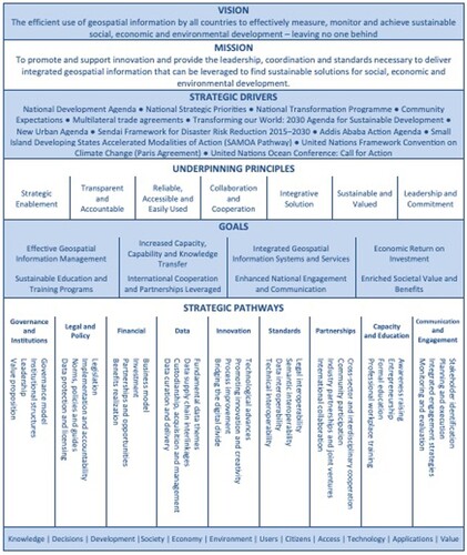
The framework is driven by the mission ‘to promote and support innovation and provide the leadership, coordination and standards necessary to deliver integrated geospatial information that can be leveraged to find sustainable solutions’. Based on this, a series of strategic drivers – in the forms of policy documents, guidelines and political agendas – is identified in connection with seven principles that underpin the enhancement of geoinformation use, notably: (1) strategic enablement; (2) transparent and accountable; (3) reliable, accessible and easily used; (4) collaboration and cooperation; (5) integrative solution; (6) sustainable and valued; (7) leadership and commitment. From here, the framework lists eight goals to be achieved about/through the enhancement and use of geoinformation: (1) effective geospatial information management; (2) increased capacity, capability and knowledge transfer; (3) integrated geospatial information systems and services; (4) economic return on investment; (5) sustainable education and training programs; (6) international cooperation and partnerships leveraged; (7) enhanced national engagement and communication; (8) enriched societal value and benefits.
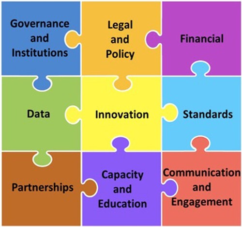
Last, the framework details nine strategic pathways that are meant to targeting the above goals. As tracks whose complying will allow to harness the full potential of geoinformation for sustainable development, the nine strategic pathways occupy a central role in the IGIF, epitomized by their visualization as jigsaw pieces to be fully integrated (). This understanding raises ethical concerns that impinge on the effective enactment of the IGIF.
Figure 2. The nine pathways of the IGIF, represented as pieces of a jigsaw. Source: http://ggim.un.org.
3. Unpacking georeferenced data and GISs
The framework assumes a positivist stance towards the evidence that georeferenced data and GISs can provide (Scott Citation2020). In fact, to turn Earth activities and phenomena into georeferenced data by means of GISs entails a ‘translation’ of the physical into the digital which affects the nature of the object of study, questioning the ‘underlying ontology of objects, location, and application on which spatial analysis was predicated’ (Pickles Citation1993, 452). Data and technology always enforce a certain worldview – one of rational efficiency – over what is being analyzed. Hence, when facing warnings like the following ones: ‘critical data for development policy-making are still lacking’ and ‘real-time data are needed to deliver better decisions faster’ (Scott and Rajabifard Citation2017, 66), the questions to be asked are: what kind of data are at stake? What is there into these ‘better decisions’ that data might not grasp?
Scholars in geomatics and human geography are not new to such topics. As Schuurman (Citation2000) discusses, an ongoing debate between critics and GIS practitioners has run through these disciplines since early 1990s. This was the time when these disciplines got increasingly automated via computer-based GIS technologies, drifting away from traditional mapping and marking a shift in the way data are ‘collected, perceived, managed and used’ (Goodchild Citation1991, 336). It is at this point that geography became primarily a matter of (automated) georeferencing, overlooking the ‘strong critiques of the reductionist ontology of spatialism’ developed by geographers in the 1980s. The risk then was to see the discipline hegemonized by technology, turning geography and mapping into a ‘trivial pursuit’ (Taylor Citation1990, 212) based on renewed tech-based ‘assumptions of objectivity, value-neutrality, and the ontological separation of subject and object’ (Lake Citation1993, 405).
From a similar perspective, the growing field of CDSs has taken issue with showing how and why data are not ‘raw’ materials to be found ‘out there’ but rather a fabrication of the activities or phenomena under exam. Technical tools, analytic practices, social subjects and objects of study are all entangled: Kitchin and Lauriault (Citation2014) seminally talk of data as ‘assemblages’, that is, ‘complex socio-technical system[s], composed of many apparatuses and elements that are thoroughly entwined’. Most importantly, such entwinement configures not only an interconnection among its parts but also a codependency across them: this means that the decisions taken by and through data-driven technologies are the result of entangled socio-technical performances which cannot be easily torn apart. At stake is a paradigm shift that demands to consider GISs, georeferenced data and related practices as part of a whole undividable ecosystem (van Loenen et al. Citation2021) in which all parts mutually affect each other and the whole. The shift from the idea of ‘framework’ or ‘model’ to the concept of ‘ecosystem’ allows to foreground a holistic and dynamic approach whereby optimal solutions are reconsidered beyond (economic) efficiency towards social justness and environmental sustainability. This requires geoinformation ecosystems to embed by default a meta-reflection on their own conditions of existence, that is, how they come into being and operate.
3.1 A critique of the framework
A major limitation of the framework has to do with the reductionist approach underpinning it. Put differently, the IGIF is built as a ‘Lego model’, whereby the combinatory convergence of the nine pathways is seen as leading by default to an optimal result. In fact, the framework relies upon a networked model – pieces, layers and actors are identified, described, juxtaposed and then integrated to provide the whole picture – in which the sum of its parts equals to the whole: ‘It is when the pieces are all joined together and united as one that the Framework is connected, integrated and able to be fully implemented’ (Scott Citation2020, 159). In doing so, the Lego model remains blind over the tradeoffs running through the framework, leading to a series of epistemological limitations that can be disentangled as follows.
To begin with, it might well be the case that some pieces of the IGIF conflict with each other. The overarching document does mention possible barriers to the implementation of the framework, but these exclusively pertain to hindrances to the collection of georeferenced data. Potential frictions within the framework are overlooked. The overarching document states that geoinformation constitutes the ‘digital currency’ for evidence-based decision-making, assuming that geoinformation is the mirror that ‘reflects the physical world in which all human, economic and environmental activity takes place’. The reflection of the ‘physical’ into the ‘digital’ by means of georeferenced data zeroes any cognizant discussion over the discrepancies that the digitalization of Earth activities and phenomena through GISs inevitably presupposes.
Similarly, to be overlooked is how the collection and management of georeferenced data might favor and/or impinge on the achievements of certain SDGs over others. This has already been highlighted by research showing that SDGs can be hardly considered as all equals (Griggs et al. Citation2016; Weitz et al. Citation2018). Weitz et al. (Citation2018, 531) note, for instance, that the agenda’s implementation is ‘complicated by the fact that targets and goals interact and impact each other in different ways’. This, in turn, demands not only to identify priorities in the pursuing of the 2030 Agenda but also to define a comprehensive approach that seeks a balance across SDGs. This is, in fact, what Weitz and colleagues set out to do, by designing a replicable methodology for the assessment of the synergies and tradeoffs among 36 targets of SDGs. In a similar vein, Griggs et al. (Citation2016) remark that, while the 2030 Agenda is considered as ‘indivisible’, hierarchies among SDGs can be identified ‘require[ing] coordinated policy interventions’. For instance, the authors note that ‘SDG16 (good governance) and SDG17 (means of implementation) are key to turning the potential for synergies into reality, although they are not always specifically highlighted as such throughout the report’: this means that these SDGs can be regarded as enablers to an overall progression of the 2030 Agenda and should be tackled upfront. Overall, these studies attest to the impossibility of addressing all SDGs on an equal footage, demanding to seek priorities and a balance across the whole 2030 Agenda. This approach shall also be transposed on the design and implementation of the IGIF.
In fact, it is hardly the case that all pieces of the framework can be considered on the same level and/or of the same kind. To think of the framework as a bidimensional jigsaw overlooks hierarchical (quantitative and qualitative) relations among the pieces. As an example, the ‘capacity and education’ and ‘communication and engagement’ pathways, which are part of the ‘people area of influence’, would be better thought of as cutting across the whole framework, being of a different (supra)order and a different kind from other, more tech-specific, pathways. This is also indirectly acknowledged (but not operationalized) in the implementation guide when stating that ‘the people aspect is arguably the most important component, as it is the people who are the Framework enablers’. Similarly, in the same way as ‘good governance’ was identified as an SDG enabling the achievement of other SDGs, it would be worth exploring how the governance layer of the framework can favor its own implementation. The flattening of all pathways to the same level prevents an effective enquiry into these issues. However, to denounce these limits cannot suffice: as Schuurman (Citation2000, 684) notes, ‘if social theorists want to influence GIS, then they must make their arguments relevant to the technology’. Taking up this call, we move on to explore the epistemological tensions underpinning the IGIF.
In this respect, an ethics perspective can do much to strengthen the thin foundation of the IGIF. As Bietti (Citation2021, 266) puts it concerning the role of ethics in regulating AI, ‘ethics [should be regarded] as a mode of inquiry that facilitates the evaluation of competing tech policy strategies’. With regard to the IGIF, ethics can be disentangled and applied as a concept and an element of the framework.
4. Revisiting the framework: an ethics-informed perspective
As a concept, ethics can help recalibrate the positivist vision underpinning the IGIF. On this point, it is worth referring to Taylor’s (Citation2021) work analyzing tracking systems’ failure during the Covid-19 pandemic. Notably, Taylor (Citation2021, 4) writes that ‘building the capacity to measure and track have often been emphasised over the ability to understand exactly what has to be measured and tracked’. Such a statement expresses an eminently ethical concern in that it taps into what (georeferenced) data can really represent, how they do that and why (i.e. what is the agenda). Taylor (Citation2021, 4) addresses these issues by denouncing the radical partiality of any data-based model and (consequential) evidence-based policy-making:
The uncertainty of the picture data provides, and particularly the new, born-digital sources of data, has always been proportional to the status and power of those it describes. Worldwide, ground truth on issues of economic wealth, public health, and even spatial location is more true for some than others.
At the same time, ethics can also become an element of the IGIF, enabling an ongoing assessment of the tensions running through the framework, both in order to question the ethical robustness of georeferenced data and practices, and as the basis for a more just pursuit of SDGs. In order to embed ethics into the framework, the article builds upon the JUDMA, which not only features ethics as one of its aspects but also provides a temporal axis to assess its maturity. Hence, the JUDMA represents a valuable starting point for integrating an ethics dimension into the IGIF. In addition, the article incorporates the ALTAI. The ALTAI is the third document released by the AI-HLEG of the European Commission, accompanying the ethics guidelines for trustworthy AI, and the policy and recommendation on trustworthy AI. Given the breadth and international recognition of the HLEG’s work, the ALTAI constitutes a valid benchmarking document against which to assess the IGIF’s ethical robustness.
4.1 JUDMA
The JUDMA was developed on behalf of the Global Partnership for Sustainable Development Data (Citation2020), in conjunction with the United Nations Statistics Division (under which also the UN-GGIM resides). This collaborative effort led to two documents: the ‘Brief’ and the ‘Guide’, which detail why and how it is crucial to implement strategies for the joining-up of data across multiple data systems. More precisely, joining-up data does not mean solely data integration, but it refers more broadly to ‘data interoperability’, which is the pivotal concept around which the JUDMA is developed. In the guide, this term is disentangled as both a concept and a characteristic of data.
As a concept, ‘data interoperability’ is meant to frame in space and time issues of ‘value, knowledge creation, collaboration, and fitness-for-purpose’ especially when it comes to data management. The JUDMA identifies four layers of interoperability: ‘organizational’, ‘human’, ‘data’ and ‘technological’. Each of these layers has its own specific dimensions: ‘data ethics’ is one dimension of the organizational layer. Then, each dimension unfolds over five levels of maturity: ‘undefined’, ‘emerging’, ‘learning’, ‘building’ and ‘consolidating’. Differently from the IGIF, then, the JUDMA considers data management as a multifaceted affair, whereby different hierarchies are identified, together with a rationale to assess the evolution of each dimension.
As far as the dimension of ‘data ethics’ is concerned, the JUDMA identifies five levels of maturity ().
Figure 3. The five maturity levels of data ethics in the JUDMA. Source: https://www.data4sdgs.org.
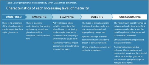
The scale goes from ‘undefined’ – i.e. ‘there is no awareness of the ethical questions that interoperable data might give rise to’ – to ‘consolidating’, notably:
The risks of harm posed by joined-up data are well understood and ethical reviews are undertaken across the data life cycle to monitor issues and course correct as needed; ethical assessments are published transparently online; an organization joins up data only once it has undertaken, and documented, a review of the potential risks of harm it might give rise to, and has taken appropriate steps to mitigate those harms.
4.2 ALTAI
In 2018, the European Commission set up a high-level group of experts from civil society, industry and academia to define a vision for ethical, secure and cutting-edge AI. Three documents were released by the group – Ethics Guidelines for Trustworthy AI, Policy and Investment Recommendations for Trustworthy AI and the ALTAI – whose key idea is ‘trustworthiness’, that is, the development and implementation of AI as lawful, ethical and robust.
The ALTAI is aimed at private and public actors alike involved in the development and implementation of AI technologies. The function of ALTAI is to provide a compass for the self-assessment of the developed and implemented technology, according to the concept of trustworthiness. The document lists a series of questions addressing the seven requirements that make AI technologies trustworthy, notably: (1) ‘human agency and oversight’; (2) ‘technical robustness and safety’; (3) ‘data governance’; (4) ‘transparency’; (5) ‘diversity, non-discrimination and fairness’; (6) ‘societal and environmental well-being’; (7) ‘accountability’.
The review of the questions attached to each one of these requirements allows to evaluate the ethical soundness of the (AI) technology under exam. The questions are descriptive in nature, rather than prescriptive and warrant a qualitative rather than quantitative assessment. While being detailed, the list of questions does not include any maturity scale against which to modulate the assessment. Hence, while ALTAI can represent a valuable blueprint for the ethical assessment of IGIF, to couple ALTAI with a maturity scale in the spirit of JUDMA can also be beneficial to ALTAI itself.
5. A proposition for the ethics assessment of geoinformation ecosystems
To operationalize an ethics-informed perspective from which to assess the IGIF, a triangulation between the seven underpinning principles of the IGIF, the JUDMA’s maturity scale and ALTAI’s requirements is provided. This will lead to draft an Ethics Assessment List for Geoinformation Ecosystems (EALGE), which can be adopted to evaluate the ethical soundness of the IGIF and similar geoinformation initiatives.
Despite different wording, the seven principles identified for the IGIF and the seven requirements of ALTAI, share various commonalities. shows the two lists and their overlaps. As the figure shows, most of ALTAI’s requirements (2, 3, 4, 5, 6 and 7) can be mapped on to IGIF’s principles 2 and 3. This highlights the extent to which for both IGIF and ALTAI, the development and implementation of (georeferenced) data technologies demand transparency, accountability, reliability, easy accessibility and fair use. At the same time, IGIF’s principles 1 and 6 find a reflection in ALTAI’s requirements 3 and 6, stressing the need for the consolidation of societal and governance mechanisms to make sure that both AI and geoinformation initiatives are inscribed into a sustainable path.
Figure 4. Commutation between ALTAI requirements and IGIF principles.
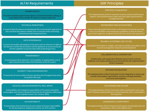
Since the ALTAI was drafted especially for AI and the IGIF’s focus is on geoinformation, the attention here is on the convergence between IGIF’s principles and ALTAI’s requirements. From here, a list of questions unpacking epistemological and ethical concerns was mutuated from the ALTAI and readapted to geoinformation initiatives (). The partial overlap among the questions was signaled already during the feedback piloting process of the ALTAI, when the list was open to comments from all interested parties, and it attests to the interdependence across the requirements and the need to address them synergically.
Table 1. List of questions addressing epistemological and ethical concerns for geoinformation ecosystems.
As a last step, we integrated the list of questions with a further dimension mutuated from the JUDMA, which identifies a maturity scale for each principle, allowing for a more granular and dynamic assessment of geoinformation ecosystems. shows the Ethics Assessment List for Geoinformation Ecosystems (EALGE) which serves as a guidance to evaluate the ethics soundness of georeferencing practices, the use of GISs and the collection, use and circulation of georeferenced data by a wide array of actors of a given ecosystem.
Table 2. EALGEs.
The interdependence across the questions and maturity levels reflects the idea that all principles (and their assessment) must be accomplished in a mutually inclusive way, i.e. by seeking a whole ecosystemic balance rather than sectorial optimization. The list can be modified and/or updated according to the nature, purposes and modalities of the examined geoinformation ecosystem, but it does force to make ethics a dimension and a core element when assessing such ecosystem. In this regard, the assessment needs be considered as an ongoing practice rather than a once-for-all process.
In turn, the EALGE can work as a lens through which to look at initiatives like the IGIF, helping to unveil their internal tensions, urging to reconsider the epistemological foundations on which they rest and favoring a structural redesign of these same initiatives.
EALGE builds around six main principles – ‘robustness’, ‘governance’, ‘transparency’, ‘diversity, non-discrimination, fairness’, ‘environmental and societal well-being’ and ‘accountability’ – and five maturity levels: ‘undefined’, ‘emerging’, ‘learning’, ‘building’ and ‘consolidating’. Based on the JUDMA, the EALGE’s maturity scale goes from ‘No awareness of epistemological and ethical issues concerning the geoinformation ecosystem’ to ‘A systemic approach to epistemological and ethical issues, identifying not only roles & responsibilities, but also best practices, mitigation mechanisms, ongoing monitoring procedures, involving third parties and training’. In-between levels of maturity are ‘Awareness across stakeholders emerges, but no leadership is taken. Epistemological and ethical issues are identified but not tackled’; ‘Leadership to address ethical issues is established, but no coordinated effort across stakeholders. Advise from third parties is also contemplated but not integrated into an organic approach’; ‘There is coordination among stakeholders concerning roles and responsibilities to tackle ethical issues, but no full implementation of a coherent plan’.
Following the ALTAI, ‘robustness’ identifies the capacity of the geoinformation ecosystem to be resilient and proactive with regard to socio-technical changes which might put on the spotlight certain ethical issues and/or create new ones. ‘Governance’ encompasses the definition and design of roles, rules, responsibilities and (redressing/mitigating) mechanisms to be shared across the ecosystem, so that it works by keeping ethical concerns in check, including the complying with data protection laws. ‘Transparency’ refers to the ecosystem’s ability to inform in a timely and cognizant way all stakeholders as well as external actors about its workings. ‘Diversity, non-discrimination and fairness’ embraces those principles that are most often addressed in the context of datafication practices and the use of data-driven technologies. These principles question the fairness of the ecosystem’s workings and results, making sure that georeferencing practices and GISs are not biased and reflect social diversity and representativeness. ‘Environmental and societal well-being’ deals with the potential (even unintended) negative impact that georeferencing practices, geospatial data and GISs might have on the environment and society at large. In this respect, the principle calls for an ex ante in-process and ex post assessment of these impacts, beyond the individual level. ‘Accountability’ relates to the ecosystem’s openness towards independent and ongoing audibility concerning its workings and how these might tap into ethical concerns. The accountability of the ecosystem also demands a thoughtful check of possible tensions among principles and tradeoff across stakeholders in georeferencing practices, the use of GISs and the collection and use of geospatial data.
6. Validating the EALGE
The EALGE was validated in a Summer school dedicated to open SDIs, held in Zagreb in August 2022, and involving the University of Zagreb, Delft University of Technology, KU Leuven, Bochum University of Applied Sciences, and Lund University. The Summer school was part of the EU-funded SPIDER project, aimed at promoting and strengthening active learning and teaching towards open SDIs (Vancauwenberghe and van Loenen Citation2018; Vancauwenberghe et al. Citation2018). The five-day Summer school involved around 35 students – BA, MA and PhDs – from around the world with backgrounds as diverse as statistics, computer sciences, geodesy and geography. During the whole week, students had the opportunity to learn about and experiment with the concept of open SDI, and its technological and nontechnological components, in a participatory way.
On the first day of the event, students were divided into five groups and asked to identify a topic for the exploration of the barriers and enablers to build an open SDI around it. Group 1 focused on improving household waste management in Amsterdam; Group 2 aimed to facilitate the tracking of climate change effects on Germany’s forests; Group 3 delved into the management of fire risks in southern Spain; Group 4 explored the mapping of hiking routes in Croatia; Group 5 investigated how to anticipate drought risks for Moroccan farmers.
On day four, the authors of this article introduced students to the ethical challenges and prospects of geoinformation ecosystems, through what-if scenarios and ethics-dilemmas roleplays. Subsequently, students were given the EALGE to be applied (and tested) to their case studies. The EALGE was not specifically designed to be applied to open SDIs, but retrospectively it proved flexible enough to fit the task. Students were given half an hour for delivering a comprehensive application of the EALGE to their case study, specifying that not necessarily all questions and five principles had to be covered, depending on the state of the art of their case study. The goal was to assess the ethical maturity of their chosen case study based on the principles, maturity levels and questions identified by the EALGE. Second, students had to provide feedback on the robustness of list, discussing possible limitations.
Concerning the ethical maturity of the chosen case studies, all the five case studies showed low levels of maturity across the five principles, going mostly from ‘undefined’ to ‘learning’, with only two case studies (climate change effects on German forests and the mapping of fire risk in Spain) showing ‘building’ levels concerning ‘robustness’ and ‘transparency’. This is likely because these cases are mostly based on non-sensitive data, favoring the consolidation of a fair(er) geoinformation ecosystem. The group focusing on waste management in Amsterdam found the ‘environmental and societal well-being’ principle of the EALGE particularly relevant because it forced them to reflect upon the possible environmental tradeoffs of an open SDI that is assumed to ‘do good for the environment’ by default. Overall, this issue remains largely untapped by open SDI ecosystems at large. Last, ‘accountability’ was the most ‘immature’ principle across all case studies as it requires a complex organization involving also third party performing fair and transparent audits.
Concerning the feedback on the EALGE, students found questions understandable, which means that the list can be used easily by a varied cohort of subjects in terms of background and levels of expertise. However, they also raised the need to clearly explain the five principles and maturity levels, because not all students were familiar with concepts such as ‘robustness’ or ‘accountability’. Moreover, it was suggested that some questions might be quite long and might be broken down and/or simplified for the sake of clarity. Interestingly, this last aspect was also noted with regard to an earlier version of the ALTAI, when it was open to public feedback and consultation.
Most importantly, students suggested that the assessment process should identify ex ante the minimum threshold for geoinformation ecosystems to be considered sufficiently ethically mature. In-class discussion after the exercise led to agree that such threshold is context-dependent, based on factors such as tech capabilities, funding allocation, length of the initiative, actors involved, etc. At the same time, however, by considering the 30-plus years of consolidation of SDIs, the five case studies under exam, and EALGE’s five maturity levels, it was deemed reasonable to identify the ‘learning’ level as the minimum threshold for an ethically robust geoinformation ecosystem.
Based on the validation experience, we amended the list accordingly (). First, we simplified the wording of some questions, across all the six principles. Alongside this, we reformulated and/or erased some redundant questions: this impacted especially principle 5 ‘diversity, non-discrimination, fairness’. Second, we embedded into the list a description of the principles – readapted from the ALTAI – to facilitate their understanding: ‘Robustness’ entails that ‘the geoinformation ecosystem must behave reliably, minimizing harm’; ‘Data Governance’ must ‘guarantee the quality and integrity of the data used in the ecosystem’; ‘Transparency’ means ‘to guarantee traceability and explicability of geoinformation ecosystem’s workings’; ‘Diversity, Non-discrimination, Fairness’ entails ‘to ensure that the geoinformation ecosystem represents diverse actors and is inclusive’; ‘Environmental and Societal Well-Being’ implies that ‘the geoinformation ecosystem must facilitate SDGs and be sustainable in its implementation’; ‘Accountability’ requires ‘to guarantee the allocation of responsibility and facilitate external audits’. Third, we highlighted the ‘learning’ level as the minimum threshold to consider a geoinformation ecosystem ethically sound.
Table 3. EALGE revised after validation.
7. Conclusion
By performing an epistemological and ethical review of the IGIF, developed by the Committee of Experts on UN-GGIM of the United Nations, the article had a two-folded goal.
On the one hand, we proposed an improvement of the IGIF by discussing ethics as both a concept and an element. This allowed us to overcome the positivist approach underpinning the framework, by showing the socio-technical thickness of any geoinformation initiative as an ecosystem, as well as to discuss how ethics can be integrated into the framework for making the achievement of SDGs more just.
On the other hand, we offered a viable path for assessing the IGIF’s (and similar geoinformation initiatives) ethics robustness through the drafting of an Ethics Assessment List for Geoinformation Ecosystems (EALGE). The EALGE blends the principles contained in the IGIF and the requirements of the ALTAI of the European Commission, together with the maturity levels for data ethics identified in the JUDMA of the Global Partnership for Sustainable Development Data. This led to identify a series of questions for six principles across five maturity levels. To use these questions as drivers allows for an ongoing assessment of the ethical robustness of geoinformation ecosystems, as well as to identify areas of improvement to make them more sustainable as enablers towards the achievement of SDGs.
In turn, if applied to the IGIF and similar frameworks, the EALGI forces to recalibrate the epistemological assumptions at their basis, favoring a redesign of their rationale in view of fairer practices. While further testing is certainly advisable, we hope to have provided an ethically robust rationale through which to look at geoinformation initiatives, whose accomplishment in a more just and ethical way remains key to the achievement of sustainable development.
Disclosure statement
No potential conflict of interest was reported by the authors.
Data availability statement
No datasets have been used for this article.
References
- AI HLEG. 2020. “Assessment List for Trustworthy Artificial Intelligence (ALTAI).” https://digital-strategy.ec.europa.eu/en/library/assessment-list-trustworthy-artificial-intelligence-altai-self-assessment
- Bietti, Elettra. 2021. “From Ethics Washing to Ethics Bashing: A Moral Philosophy View on Tech Ethics.” Journal of Social Computing 2 (3): 266–283. doi:10.23919/JSC.2021.0031
- CEOS. 2018. “Earth Observation Handbook Special 2018 Edition: Satellite Earth Observations in Support of the Sustainable Development Goals.” http://eohandbook.com/sdg/index.html
- Crompvoets, Joep, Abbas Rajabifard, Bastiaan Van Loenen, and T. Delgado Fernández. 2008. A Multi-View Framework to Assess Spatial Data Infrastructures. Melbourne: Melbourne University Press.
- Dencik, Lina, Arne Hintz, and Jonathan Cable. 2016. “Towards Data Justice? The Ambiguity of Anti-Surveillance Resistance in Political Activism.” Big Data & Society 3 (2): 1–12. doi:10.1177/2053951716679678
- Global Partnership for Sustainable Development Data. 2020. “Joined-Up Data Maturity Assessment”. https://www.data4sdgs.org/resources/joined-data-maturity-assessment
- Goodchild, Michael F. 1991. “Just the Facts.” Political Geography Quarterly 10: 335–337. doi:10.1016/0260-9827(91)90001-B
- Griggs, David, Mans Nilsson, A. Stevance, and David McCollum. 2016. A Guide to SDG Interactions: From Science to Implementation. Paris: International Council for Science. https://council.science/publications/a-guide-to-sdg-interactions-from-science-to-implementation/
- Kitchin, Rob, and Tracy Lauriault. 2014. “Towards Critical Data Studies: Charting and Unpacking Data Assemblages and Their Work.” https://mural.maynoothuniversity.ie/5683/1/KitchinLauriault_CriticalDataStudies_ProgrammableCity_WorkingPaper2_SSRN-id2474112.pdf
- Lake, Robert. 1993. “Planning and Applied Geography: Positivism, Ethics, and Geographic Information Systems.” Progress in Human Geography 17: 404–413. doi:10.1177/030913259301700309
- Metcalf, Jacob, and Kate Crawford. 2016. “Where Are Human Subjects in Big Data Research? The Emerging Ethics Divide.” Big Data & Society 3: 1. doi:10.1186/s40537-015-0036-x
- Pickles, John. 1993. “Discourse on Method and the History of Discipline: Reflections on Jerome Dobson’s 1993 ‘Automated Geography’.” Professional Geographer 45: 451–455. doi:10.1111/j.0033-0124.1993.00451.x
- Schuurman, Nadine. 2000. “Trouble in the Heartland: GIS and Its Critics in the 1990s.” Progress in Human Geography 24 (4): 569–590. doi:10.1191/030913200100189111
- Scott, Gregory. 2020. “A National Strategic Geospatial Information Framework to Support the Implementation of the Sustainable Development Goals (SDGs).” Doctoral diss., https://minerva-access.unimelb.edu.au/items/fa93bcfd-3331-5012-99e6-4d73580fe850/full
- Scott, Gregory, and Abbas Rajabifard. 2017. “Sustainable Development and Geospatial Information: A Strategic Framework for Integrating a Global Policy Agenda Into National Geospatial Capabilities.” Geo-spatial Information Science 20 (2): 59–76. doi:10.1080/10095020.2017.1325594
- Taylor, Peter J. 1990. “GKS.” Political Geography Quarterly 9: 211–212. doi:10.1016/0260-9827(90)90023-4
- Taylor, Linnet. 2021. “The Price of Certainty: How the Politics of Pandemic Data Demand an Ethics of Care.” Big Data & Society 7: 2. doi:10.1177/2053951720942539.
- UN-GGIM. 2020. “Integrated Geospatial Information Framework (IGIF).” https://ggim.un.org/IGIF/
- United Nations. 2002. “Report of World Summit on Sustainable Development.” New York: United Nations. A/CONF.199/20.
- United Nations. 2015. “Transforming Our World: The 2030 Agenda for Sustainable Development.” New York: United Nations. A/RES/70/1.
- Vancauwenberghe, Glenn, Kotryna Valečkaitė, Bastiaan Van Loenen, and Frederika Welle Donker. 2018. “Assessing the Openness of Spatial Data Infrastructures (SDI): Towards a Map of Open SDI.” International Journal of Spatial Data Infrastructures Research 13: 88–100. doi:10.2902/1725-0463.2018.13.art9.
- Vancauwenberghe, Glenn, and Bastiaan van Loenen. 2018. “Exploring the Emergence of Open Spatial Data Infrastructures: Analysis of Recent Developments and Trends in Europe.” In User-centric E-Government. Challenges and Opportunities, edited by Saqid Saeed, T. Ramayah, and Zaigham Mahmood, 23–45. New York: Springer International Publishing.
- Van Loenen, Bastiaan, Anneke Zuiderwijk, Glenn Vancau-Wenberghe, Francisco J. Lopez-Pellicer, Ingrid Mulder, Charalampos Alexopoulos, Rikke Magnussen , et al. 2021. “Towards Value-creating and Sustainable Open Data Ecosystems: A Comparative Case Study and a Research Agenda.” JeDEM-eJournal of eDemocracy and Open Government 13 (2): 1–27.
- Weitz, Nina, Henrik Carlsen, Måns Nilsson, and Kristian Skånberg. 2018. “Towards Systemic and Contextual Priority Setting for Implementing the 2030 Agenda.” Sustainable Science 13: 531–548. doi:10.1007/s11625-017-0470-0