Abstract
Methane and nitrous oxide are potent greenhouse gases whose atmospheric abundances have increased significantly in the past 200 years, together accounting for approximately half of the radiative forcing associated with increasing concentrations of carbon dioxide. In order to understand the factors causing increase of these gases globally, we need to determine their emission rates at regional to continental scales. We directly link atmospheric observations with surface emissions using a Lagrangian Particle Dispersion Model, and then determine emission rates by optimizing prior emissions estimates. We use measurements from NOAA's tall tower and aircraft program in 2004, The Stochastic Time-Inverted Lagrangian Transport model (STILT) driven by meteorological fields from a customized version of the Weather Research and Forecasting (WRF) model, and EDGAR32FT2000 and Global Emissions Inventory Activity (GEIA) as prior emission estimates. In the US and Canada, methane emission rates are found to be consistent with observations, while nitrous oxide emissions are significantly low, by a factor 2.5–3 in the peak emissions time period found to be February through May.
Keywords:
1. Introduction
In the current environment of rising greenhouse gas concentrations and potential resultant consequences, atmospheric evidence of emissions of these gases is crucial in understanding their impact on current and future climate and guiding relevant policy. Though much attention has focused on carbon dioxide as the single most important anthropogenic greenhouse gas (Hofmann et al. Citation2006), non-CO2 greenhouse gases play a significant role in the Earth's energy balance. Non-CO2 greenhouse gases contribute a comparable amount to radiative forcing as carbon dioxide (Hofmann et al. Citation2006), with methane and nitrous oxide as the first and secondFootnote1 largest contributors, respectively.
Many global-scale studies have investigated emissions of methane and nitrous oxide (Prinn et al. Citation1990; Chen and Prinn Citation2006; Hirsch et al. Citation2006; Houweling et al. Citation2006; Bergamaschi et al. Citation2007; Nevison et al. Citation2007; Huang et al. Citation2008). These studies help immensely to improve understanding of emissions at large spatial and temporal scales (continental and annual). Studies on a more focused spatial and temporal scale, such as those performed by Miller et al. (Citation2007), have been more limited. Recent work (Kort et al. Citation2008) examining US and Canadian emissions in Spring 2003 indicated methane emissions were consistent with predictions (49 Tg CH4/year), while nitrous oxide emissions were 2.5–3 times higher than predicted by Emissions Database for Global Atmospheric Research (EDGAR) or Global Emissions Inventory Activity (GEIA). These results leave open questions about seasonal variation and annual total emissions of nitrous oxide and methane. Are nitrous oxide emissions two to three times larger than expected for the full calendar year? In this work, we target these questions by examining measurements collected in 2004 from aircraft and towers. By focusing on areas adjacent to particular receptor sites, our analysis provides a preliminary assessment for the application of these types of observations for verification of reported emissions at regional scales.
2 Measurements
Flask samples collected in 2004 from aircraft performing vertical profiling and from tall towers were used in this study. All flasks were analyzed at NOAA/ESRL for CO2, CO, CH4, H2, SF6, and N2O dry air mole fractions. Methane and nitrous oxide measurements used here are calibrated on the NOAA2004 (Dlugokencky et al. Citation2005) and NOAA2006 (Hall et al. Citation2007) scales, respectively. Vertical profiling measurements used in the methane analysis were collected at three sites representing different regions of North America: a remote plain site in Briggsdale, Colorado (CAR, 40.37° N, −104.30° W, 2000–8000 masl), a remote forested site in Park Falls, Wisconsin (LEF, 45.93° N, −90.27° W, 500–4000 masl), and a more urban site in Worcester, Massachusetts (NHA, 42.95° N, −70.63° W, 500–7000 masl). Tall tower measurements used in the nitrous oxide analyses were collected at the LEF site (45.93° N, −90.27° W, 472 masl). Climatologically, 2004 was wetter than average in the Southern and Eastern US, though the Western US had a continuation of a multi-year drought. The Northeast and Central US as far north as Central Canada experienced colder than average summers.
3 Methodology
The analysis approach here closely follows prior work outlined in Kort et al. (Citation2008). The scheme represents the application of a “top-down” method as a check on “bottom-up” inventories. Measurements and prior emissions estimates are linked together in a regional modeling framework built upon a Lagrangian Particle Dispersion Model (LPDM), the Stochastic Time-Inverted Lagrangian Transport Model (STILT) (Lin et al. Citation2003). With this technique we can predict mixing ratios of specific gases at the time and location of a measurement based upon prior emissions estimates. This facilitates direct comparison and assessment of the accuracy of the prior flux estimates.
3.1 Meteorological input
We drive STILT with meteorological fields from the Weather Research and Forecasting (WRF) model (Skamarock et al. Citation2005). WRF is run in the same customized manner as described by Kort et al. (Citation2008), ensuring mass conservation, with the addition of a nested 10-km domain within the larger 40-km domain.
3.2 Footprint estimation, emissions inventories, and upwind boundary condition
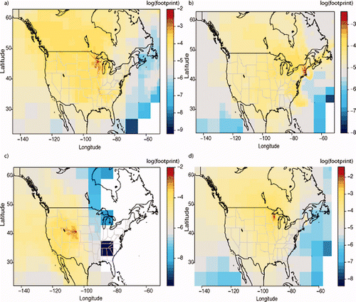
Using the WRF fields, STILT transports ensembles of 500 particles backwards in time for 10 days for each point in space and time where flask samples were collected (receptor point). From these trajectories, we calculate a footprint for each receptor point representing the sensitivity of the receptor point to surface fluxes, in units of ppb/(μmol m−2s−1). Average footprints for the four measurement locations are visualized in . Multiplying the footprint by a prior flux field gives the enhancement predicted at the receptor point due to the estimated fluxes. Addition of this value to a boundary condition term, derived by assigning a mixing ratio to a particle as it crosses −145° W, allows for direct comparison between modeled and measured values. Prior flux fields used here are EDGAR 32FT2000 (Olivier et al. Citation2005) with the “JK” wetland inventory (Bergamaschi et al. Citation2007) for CH4 and EDGAR 32FT2000 and GEIA (Bouwman et al. Citation1995) for N2O (as described in more detail in Kort et al. (Citation2008)). For N2O, GEIA includes both natural and anthropogenic sources, while EDGAR only includes anthropogenic. Boundary condition values used here are derived from interpolation between data collected over the Pacific for methane, as done by Gerbig et al. (Citation2003) for CO and CO2, and by temporal interpolation of free tropospheric values measured in aircraft profiles above LEF for nitrous oxide. For nitrous oxide, this boundary approach should account for larger scale stratospheric influence on tropospheric N2O mixing ratios, and stratospheric influence not captured here would translate to model results over-predicting mixing ratios, and therefore underestimating sources.
Figure 1. Average footprint of aircraft measurements (a) at LEF (b) at NHA (c) at CAR (d) of measurements made at the tall tower at LEF. Dynamic resolution is used in plotting, with grid boxes increasing in size at greater distances from receptor origin.
3.3 Optimization approach
In assessment of methane emissions, we follow the same optimization approach outlined by Kort et al. (Citation2008). For both LEF and NHA, we apply a χFootnote2 fit (fitexy) between modeled and measured values including uncertainties in both x and y (Press et al. Citation1992). We find one scaling factor, the inverse of the fit slope, for the entire emissions field. This approach assumes constant errors in the prior emissions field and finds different scaling factors for the different sites; each nominally applies to the entire emissions field, but in fact applies only to the small regions defined by the footprint (). Uncertainties in the scaling factor are directly retrieved from the χFootnote2 fit, and are defined by the uncertainties included in the fitting (measurement error, model-data mismatch, boundary condition error, particle statistic error, aggregation error in flux fields, and transport error, as defined by Kort et al. (Citation2008)). This approach offers a simple one-parameter optimization insensitive to constant biases in the advected boundary condition. It assumes that the slope is driven by emissions, not boundary variation, and that error in the spatial distribution of the prior emissions fields do not contribute.
4 Results: methane
4.1 Briggsdale, Colorado (CAR)
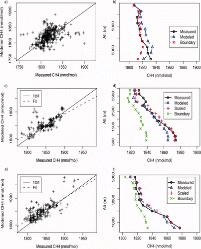
Profiles at CAR see weaker upwind emissions that are well mixed vertically, only occasionally encountering plumes influenced by large local sources such as natural gas extraction sites. The vertical profile shows little variation with altitude (), and the measured vs. modeled graph predominantly shows point-to-point scatter representative of error in the advected boundary condition (). The absence of a strong source signature renders the fit-optimization method moot, as model and measurements mostly agree and most points have little or no surface emission influence; thus no optimization is attempted at CAR.
Figure 2. (a) Comparison of measured and modeled values at CAR with 1 to 1 line. (b) Average, binned vertical profile at CAR. (c) Modeled vs. measured with fit at LEF. (d) Average, binned vertical profile at LEF. (e) Modeled vs. measured with fit at NHA. (f) Average, binned vertical profile at NHA.
4.2 Park Falls, Wisconsin (LEF)
Measurements at LEF show a significant signature of sources, as seen in the strong vertical gradient (). Seasonality in the methane values is seen due to variations in the latitudinal origins of the air mass seen at LEF, and the seasonal variation of the upwind boundary condition (largely due to OH). Fitting the model vs. measurement, using the same uncertainty approach as in Kort et al. (Citation2008), finds a slope of 0.76 ± 0.15 (2-sigma), which converts to a scaling factor of 1.3 ± 0.3.
4.3 Worcester, Massachusetts (NHA)
At NHA enhancement in the boundary layer due to regional emissions also presents itself as a strong vertical gradient (). Again seasonality lies not within the sources, so much as in the origins in the air mass seen at NHA. Fitting model vs. measurement for NHA finds a slope of 0.84 ± 0.14, which converts to a scaling factor of 1.2 ± 0.2.
4.4 Boundary condition
Due to seasonal changes and a large latitudinal gradient, the upwind boundary conditions appear to be biased based on a comparison between model and measured mixing ratios in the free troposphere at NHA and LEF. At NHA a bias of 13 ppb is found by considering all modeled and measured data above 3 km, and this bias is removed from the boundary condition in plotting . At LEF, much sparser free troposphere data are available, so the full column average is considered, retrieving a bias of 9 ppb between measured and scaled-modeled columns, and this bias is removed from the boundary condition in plotting . Because our analysis is focused on the scaling factor, or slope, between modeled and measured data the bias, or intercept, is not critical to our analysis. Nevertheless, the variability in the bias between stations would add significant uncertainty to inverse analysis where observations at multiple sites were used to estimate fluxes from specific regions.
4.5 Source partitioning
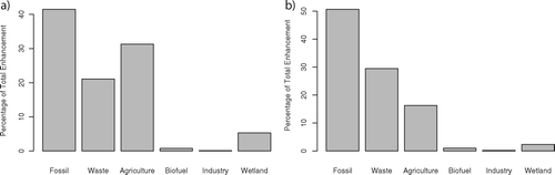
illustrates the contributions of different source categories (as defined in EDGAR + wetlands) at LEF and NHA according to model results (note the retrieved scaling factor is applied uniformly to all EDGAR categories). Strong regional sources of fossil fuel use, agriculture, and waste handling (EDGAR categories) produce the majority of the enhancement in the boundary layer at both LEF and NHA. We are not primarily detecting natural sources with these measurements; instead we are constraining anthropogenic sources. We cannot distinguish these purely from the measurements, but instead rely on the model to partition sources. The agreement between model and measurement suggest the prior emissions fields accurately distribute and partition the different methane sources. Fire emissions are not included in the analysis, as very few flasks considered were strongly influenced by biomass burning, as indicated by CO values generally being less than 200 ppb.
Figure 3. Percentage contribution of different source categories in the model (a) at LEF. (b) at NHA.
5 Results: nitrous oxide
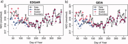
LEF lies in close proximity to large agricultural lands, advantageous in assessing seasonality of nitrous oxide emissions. Prior emissions from both EDGAR and GEIA are considered. Resulting time series can be seen in . For both EDGAR and GEIA, model and measurements closely agree for summer, fall, and early winter, but late winter and spring show large deviations between model and measurements. R-squared values for the model results are 0.34 and 0.25, respectively for EDGAR and GEIA. By applying the scaling factors found during spring by Kort et al. (Citation2008) (2.62 & 3.05 for EDGAR and GEIA) to just the late winter and spring months (February through May), the agreement improves dramatically, resulting in R 2 values of 0.59 and 0.50. Application of this scaling factor for the full year, or different time windows worsens model-data agreement. This temporal application of the scaling is mostly consistent with the enhanced emissions being agriculturally related: flux measurements at an agricultural site in Ontario, Canada (similar latitude to LEF) find nitrous oxide emissions peaks occurring roughly in this same time domain (Wagner-Riddle et al. Citation2007).
Figure 4. (a) Time series of measurements (black circle), boundary condition (black dashed), prior model with EDGAR (blue triangle), and the model scaled in late winter and spring (red cross). (b) same as (a), except the emissions model is GEIA.
6 Conclusions
Findings here expand upon prior work analyzing COBRA-NA data from the spring of 2003. Consideration of a full calendar year indicates that prior methane emissions estimates from EDGAR32FT2000 are consistent with observations, as found by Kort et al. (Citation2008). We did note scaling factors of 1.2 and 1.3, indicating emissions could be somewhat higher, but these scaling factors are of marginal statistical significance as they fall at the limit of what can be resolved with current data sets and techniques. Other regional top-down studies in the US have either found EDGAR32FT2000 emissions to be consistent or low (Wunch et al. Citation2009; Zhao et al. Citation2009). The recently released EDGAR v4.02 reduces US anthropogenic emissions by 30%, and this reduction is neither consistent with this nor prior studies.
Nitrous oxide findings support the view that high emission rates derived for spring from COBRA-NA reflect seasonality of the emissions, with strongest emissions in late winter and early spring. We estimate total US and Canadian anthropogenic nitrous oxide emissions to be larger than EDGAR's 1.6 Tg N2O/year by 0.9 ± 0.2 Tg N2O/year, summing to ∼2.5 Tg N2O/year, with 1.4 Tg emitted over the 4-month peak (February through May) and 1.1 Tg emitted over the remaining 8 months. Considering global emissions as reported by the IPCC (Denman et al. Citation2007), these emissions would represent 9% of the total global N2O source, and 24% of the anthropogenic source.
By focusing on relatively small areas (104–105 km2) representing the flux-weighted footprint, this work provides a preliminary assessment for using atmospheric observations to verify reported emissions. Using currently available data, we can resolve discrepancies in methane emissions larger than 20–30% on a regional scale. Limitations include: potential bias in footprint strength, varying boundary condition bias with altitude, and the influence of errors in the assumed spatial distribution of emissions. The latter two problems can be addressed by denser spacing of aircraft data, satellite data to help define the boundary condition, and the application of more sophisticated inversions to reduce reliance on prior emissions fields (Michalak et al. Citation2004; Meirink et al. Citation2008).
Notes
2. European Commision, Joint Research Centre (JRC)/Netherlands Environmental Assessment Agency (PBL). Emission Database for Global Atmospheric Research (EDGAR), release version 4.0. http://edgar.jrc.ec.europa.eu, 2009
Related Research Data
References
- Bergamaschi , P , Frankenberg , C , Meirink , J F , Krol , M , Dentener , F , Wagner , T , Platt , U , Kaplan , J O , Körner , S Heimann , M . 2007 . Satellite chartography of atmospheric methane from SCIAMACHY on board ENVISAT: 2. Evaluation based on inverse model simulations . J Geophys Res. , 112 : D02304
- Bouwman , A F , van der Hoek , K W and Olivier , J GJ . 1995 . Uncertainties in the global source distribution of N2O . J Geophys Res. , 100 ( D2 ) : 2785 – 2800 .
- Chen , Y-H and Prinn , R G . 2006 . Estimation of atmospheric methane emissions between 1996 and 2001 using a three dimensional global chemical transport model . J Geophys Res. , 111 : D10307
- Denman , K L , Brasseur , G , Chidthaisong , A , Ciais , P , Cox , P M , Dickinson , R E , Hauglustaine , D , Heinze , C , Holland , E Jacob , D . 2007 . “ Couplings between changes in the climate system and biogeochemistry ” . In Climate change 2007: the physical science basis. Contribution of Working Group I to the Fourth Assessment Report of the Intergovernmental Panel on Climate Change , Edited by: Solomon , S , Qin , D , Manning , M , Chen , Z , Marquis , M , Averyt , K B , Tignor , M and Miller , H L . Cambridge, UK and NewYork, NY, , USA : Cambridge University Press .
- Dlugokencky , E J , Myers , R C , Lang , P M , Masarie , K A , Crotwell , A M , Thoning , K W , Hall , B D , Elkins , J W and Steele , L P . 2005 . Conversion of NOAA atmospheric dry air CH 4 mole fractions to a gravimetrically prepared standard scale . J Geophys Res. , 110 : D18306
- Gerbig , C , Lin , J C , Wofsy , S C , Daube , B C , Andrews , A E , Stephens , B B , Bakwin , P S and Grainger , C A . 2003 . Toward constraining regional-scale fluxes of CO2 with atmospheric observations over a continent: 1. Observed spatial variability from airborne platforms . J Geophys Res. , 108 ( D24 ) : 4757
- Hall , B D , Dutton , G S and Elkins , J W . 2007 . The NOAA nitrous oxide standard scale for atmospheric observations . J Geophys Res. , 112 : D09305
- Hirsch , A I , Michalak , A M , Bruhwiler , L M , Peters , W , Dlugokencky , E J and Tans , P P . 2006 . Inverse modeling estimates of the global N2O surface flux from 1998–2001 . Global Biogeochem Cycles. , 20 : GB1008
- Hofmann , D J , Butler , J H , Dlugokencky , E J , Elkins , J W , Masarie , K , Montzka , S A and Tans , P . 2006 . The role of carbon dioxide in climate forcing from 1979–2004: introduction of the Annual Greenhouse Gas Index . Tellus Ser B. , 58 : 614 – 619 .
- Houweling , S , Röckmann , T , Aben , I , Keppler , F , Krol , M , Meirink , J F , Dlugokencky , E J and Frankenberg , C . 2006 . Atmospheric constraints on global emissions of methane from plants . Geophys Res Lett. , 33 : L15821
- Huang , J , Golombek , A , Prinn , R , Weiss , R , Fraser , P , Simmonds , P , Dlugokencky , E J , Hall , B , Elkins , J Steele , P . 2008 . Estimation of regional emissions of nitrous oxide from 1997 to 2005 using multinetwork measurements, a chemical transport model, and an inverse method . J Geophys Res. , 113 : D17313
- Kort , E A , Eluszkiewicz , J , Stephens , B B , Miller , J B , Gerbig , C , Nehrkorn , T , Daube , B C , Kaplan , J O , Houweling , S and Wofsy , S C . 2008 . Emissions of CH4 and N2O over the United States and Canada based on a receptor-oriented modeling framework and COBRA-NA atmospheric observations . Geophys Res Lett. , 35 : L18808
- Lin , J C , Gerbig , C , Wofsy , S C , Andrews , A E , Daube , B C , Davis , K J and Grainger , C A . 2003 . A near-field tool for simulating the upstream influence of atmospheric observations: the Stochastic Time-Inverted Lagrangian Transport (STILT) model . J Geophys Res. , 108 ( D16 ) : 4493
- Meirink , J F , Bergamaschi , P and Krol , M C . 2008 . Four-dimensional variational data assimilation for inverse modeling of atmospheric methane emissions: method and comparison with synthesis inversion . Atmos Chem Phys. , 8 ( 21 ) : 6341 – 6353 .
- Michalak , A M , Bruhwiler , L and Tans , P P . 2004 . A geostatistical approach to surface flux estimation of atmospheric trace gases . J Geophys Res. , 109 ( D14 ) doi: 10.1029/2003J D004422
- Miller , J B , Gatti , L V , d'Amelio , M TS , Crotwell , A M , Dlugokencky , E J , Bakwin , P , Artaxo , P and Tans , P P . 2007 . Airborne sampling reveals large methane enhancement over the Amazon basin . Geophys Res Lett. , 34 : L10809
- Nevison , C D , Mahowald , N M , Weiss , R F and Prinn , R G . 2007 . Interannual and seasonal variability in atmospheric N2O . Global Biogeochem Cycles. , 21 : GB3017
- Olivier , J GJ , Van Aardenne , J A , Dentener , F , Ganzeveld , L and Peters , J AHW . 2005 . “ Recent trends in global greenhouse gas emissions: regional trends and spatial distribution of key sources ” . In Non-CO2 greenhouse gases (NCGG-4) , Edited by: van Amstel , A . 325 – 330 . Rotterdam : Millpress . ISBN 90 5966 043 9
- Press , W H , Teukolsky , S A , Vetterling , W T and Flannery , B P . 1992 . Numerical recipes in FORTRAN: the art of scientific computing , 2nd ed , New York : Cambridge University Press .
- Prinn , R , Cunnold , D , Rasmussen , R , Simmonds , P , Alyea , F , Crawford , A , Fraser , P and Rosen , R . 1990 . Atmospheric emissions and trends of nitrous oxide deduced from 10 years of ALE-GAGE data . J Geophys Res. , 95 ( D11 ) : 18,369–18,385
- Skamarock , W C , Klemp , J B , Dudhia , J , Gill , D O , Barker , D M , Wang , W and Powers , J G . 2005 . A description of the advanced research WRF version 2. Technical Note 468+STR, MMM Division, NCAR, Boulder, CO, 88 p cited 2009 May. Available from: http://www.mmm.ucar.edu/wrf/users/docs/arw_v2.pdf.
- Wagner-Riddle , C , Furon , A , McLaughlin , N L , Lee , I , Barbeau , J , Jayasundara , S , Parkin , G , von Bertoldi , P and Warland , J . 2007 . Intensive measurement on nitrous oxide emissions from a corn-soybean-wheat rotation under two contrasting management systems over 5 years . Global Change Biol. , 13 : 1722 – 1736 .
- Wunch , D , Wennberg , P O , Toon , G C , Keppel-Aleks , G and Yavin , Y G . 2009 . Emissions of greenhouse gases from a North American megacity . Geophys Res Lett. , 36 : L15810
- Zhao , C F , Andrews , A E , Bianco , L , Eluszkiewicz , J , Hirsch , A , MacDonald , C , Nehrkorn , T and Fischer , M L . 2009 . J Geophys Res. , 114 : D16302