
Abstract
There has always been a link between water and desertification. Water, whether from rain or other sources, provides the ground moisture needed for the growth of vegetation cover. The availability of water resources directly affects the distribution of vegetation cover. Any damage to the vegetation cover is almost always accompanied by silting, which accelerates the desertification process. The phenomenon of desertification affects the arid and semi-arid areas of all continents. Its expansion is one of the major environmental problems of our times. According to the United Nations Convention to Combat Desertification, the term desertification signifies ‘‘land degradation resulting from various factors including climatic variations and human activities”. The problem of desertification, which is known as being the process of land degradation resulting principally from anthropogenic factors (plowing of steppe, overgrazing, land clearing, fires, deforestation (illegal logging), etc.) and leading to often irreversible repercussions, is a particular and urgent problem in the arid and semi-arid bioclimatic zones of the Tell Atlas. This work is part of the monitoring of desertification and of the impact of natural factors (soils, hydrology, vegetation and climate) in an area in the heart of south Oran’s high steppe plains, in the El Bayadh region of Algeria.
1. Introduction
In Bali, in December 2007, the Conference of the Parties to the United Nations Framework on Climate Change Convention (UNFCCC) underscored the vulnerability of many nations to future desertification under climate change. As recently as April 2008, the intergovernmental panel on climate change stated with high confidence that ‘‘globally, the negative impacts of future climate change on fresh water systems are expected to outweigh the benefits.” Citation[1]
Desertification is a worldwide phenomenon, affecting about one-fifth of the world population, 70% of all dry lands (3.6 billion ha) and one-quarter of the total land area of the world Citation[2]. The vulnerability of land to desertification is mainly due to climate, the state of the soil, water, natural vegetation, and the ways in which these resources are used. Vulnerability varies widely depending on the way in which the natural resources are used by human communities and their livestock. Globally, every year, an additional 200,000 km2 of productive land is reduced by desertification to the point of yielding nothing Citation[3]. Therefore, desertification is considered one of the most worrying environmental problems of the twenty-first century. Desertification refers to land degradation, linked to the socio-economic use of natural resources beyond their capacity to replenish, often exacerbated by fluctuations in climatic conditions.
Water is essential for maintaining life. Humans and animals usually settle around permanent sources of water. However, the exploitation of water resources around human settlements increases the pressure on the environment and the risk of desertification. There are several causes of desertification, including frequent droughts, deforestation, intensive farming and overgrazing.
The forest ecosystem in Algeria Citation[4] is characterised by a fragility caused by climatic factors (prolonged drought, low and erratic rainfall, high thermal amplitude). For the wilaya of El Bayadh, which encompasses both the semi-arid and the arid bioclimatic stages, the situation is even more serious. Forest ecosystems are in a perpetual struggle due to climatic fluctuations, which have been expressed using parameters termed indicators of desertification Citation[5]. This gives rise to a floristic structure and composition which are the result of the natural and human factors of the environment.
The main objective of this study is to evaluate climatic, soil, hydrology and vegetation parameters and their influence on desertification in the region of El Bayadh (Algeria).
2 Materials and methods
2.1 Geographical position
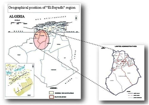
The wilaya of El Bayadh is located in northwestern Algeria. It is bordered in the north by the Saida and Tiaret provinces, in the east and southeast by Laghouat, Ghardaia and Adrar and in the west and southwest by Sidi Bel Abbes, Naama and Bechar. It forms part of the ‘‘West Highlands” programme area, as do the wilayas of Tiaret Nâama, Saida and Tissemssilet (Fig. ).
Fig. 1 Geographical position of the study area ‘‘El Bayadh”.
The altitude decreases from about 1,000 m in the north, to about 500 m in the extreme south of the wilaya. In the north, agricultural activity is limited to the oases, especially in the Brézina area. This area is characterised by rugged, hilly terrain and a dry, sub-Saharan climate.
The geology and lithology of the area also constitute an important element for the study and knowledge of these surroundings. The nature of the terrain is one of the principal factors influencing which land is chosen for development. Structurally, the wilaya of EL Bayadh is composed of three different zones:
The High Plains
The Saharan Atlas
The Saharan Platform
2.2 Measure
Precipitation was measured using a rain gauge. This instrument is used to record the amount of precipitation falling on a given surface. It is composed of a collection funnel, a tank and a measuring cylinder. To measure the amount of precipitation, the water collected in the tank is transferred into the graduated measuring cylinder if the tank itself is not graduated. Solid precipitation (snow, hail …) is measured after it has melted. Furthermore, wind speed was measured using an anemometer, and wind direction was recorded using a wind vane.
3 Results and discussion
3.1 Soil classification
We have located five classes of soil in the wilaya of El Bayadh (Table ). This data have been obtained from the Forest Service of the wilaya of El Bayadh. Classes vulnerable and very vulnerable to desertification represent 45 and 36% of the total area of the region, respectively.
3.1.1 Areas that show little or no vulnerability to desertification
This is the case of the regions carpeted with a ‘‘pre-forest” vegetation cover, growing in raw mineral soils produced by erosion, at the extreme northern end of the wilaya (Mousbah), with an area of 31255.71 ha (0.44%).
Table 1. Land area for soils of different classes of vulnerability (Forest Service of the wilaya of El Bayadh, 2012)
3.1.2 Areas moderately vulnerable to desertification
Soils resting on limestone (calcimagnesian soils), as well as little-evolved soils produced by erosion with moderate vegetation cover, show moderate vulnerability to desertification. These are found in the northern area of the province extending to Bougtob-El Kheiter, an area of 1144627.8 ha (15.97%).
3.1.3 Areas vulnerable to desertification
Areas with a vegetation cover consisting of degraded or severely degraded vegetation (psamophytes, bare soil) growing in evolved soils (calcimagnesian soils), little-evolved soils (formed from the erosion of outcrops of sandstone or limestone) and little-evolved alluvial soils are classified as vulnerable to desertification. This class of soil was found in the regions of Tousmouline, Rogassa, Kef Lahmar, Cheguig and parts of Mehara, comprising a total area of 3240757.76 ha (45.20%).
3.1.4 Areas highly vulnerable to desertification
Degraded and very degraded rangelands consist of very degraded psamophyte steppe vegetation and vegetation from the Alfa, Artemisia Herba-Alba and Artrophytum-Scoparium groups, lying on different types of edaphic support of a sandy texture, and overlain with a veil of sand. They were found in the regions of El Bayadh, Boualem, Sidi Amar, Sidi Taiffour, Sidi Slimane, Stitten, Ghassoul, Krakda, Ain El Orak, Arbaouet, Chellala, Mehara and Boussemghoun; this land is excessively vulnerable to desertification and occupies nearly 2594871.41 ha (36.19%).
3.1.5 Desertified areas
This is the case of the extreme southern regions of the province. The pre-Sahara consists of only three municipalities that are the following: Brezina, El Abiodh Sidi Sheikh and Bnoud, where we note the presence of the Western Erg, due to which the desertified nature of the area is intensified by a longer and warmer summer. Winter is marked by frosts and temperatures approaching 0°C. The pastures are very poor and plant density is low. Here, no profitable agriculture is possible outside the oasis. These areas represent an area of 157714.35 ha (2.20%).
3.2 Climate framework
The effects of desertification on climate [Citation6–Citation7] have been described mainly in terms of changes in land use and land cover leading to land degradation; overgrazing; biomass burning and atmospheric emissions; agriculture’s contribution to air pollution; forest and woodland clearing and accelerated wind erosion; anthropogenic land disturbances and wind erosion; and the impact of irrigated agriculture on surface conditions in drylands [Citation8–Citation11].
The Mediterranean climate is characterised as a whole by the alternation of two distinct seasons: one characterised by hot and dry summers and the other by rainy and relatively cool autumn and winter seasons. The climate of the steppe areas is Mediterranean and is characterised particularly by lower rainfall and a high inter-individual variability in monthly and inter-annual thermal regimes that are relatively homogeneous, highly contrasting and of a continental type. The discussion on the link between climate change or climate variations and desertification is not conclusive Citation[12].
In 1990, a researcher tipped the balance in favor of a direct link when he found that about 70% of desertification is due to uncontrollable natural events such as weather events and population growth, and recommended that research be done on climate and the population in order to address the problem. A similar view was expressed by the Swedish team which worked in Sudan for over 30 years. The team, like others, concluded that all widespread changes in vegetation cover that occurred could be explained by variations in climate and that the variation in yield was mainly due to climatic variation rather than a secular trend [Citation13,Citation14].
According to two other scientists, drought may accelerate land degradation by reducing the water yield in a system already unbalanced as a result of abusive exploitation. Land degradation can, in turn, contribute to drought by feedback mechanisms involving the albedo of the surface, soil moisture and possibly dust Citation[15].
Our study focuses on the region of El Bayadh. We are interested in following the extent of this phenomenon and assessing the factors influencing this imbalanced system, namely the influence of climatic factors that serve as indicators: rainfall, temperature and wind.
3.2.1 Rainfall
Table shows the monthly rainfall of the El Bayadh Metrology Station, which represents the rainfall of the municipalities of Cheguig and Rogassa. We can state that in both of these towns (Cheguig and Rogassa) there is an increased tendency towards aridity because rainfall is scarce. The wet season runs from October to January with a maximum of 109.3 mm of rainfall reached during the month of October.
Table 2. Mean Monthly rainfall of El Bayadh Metrology Station (1971–2010)
According to (Fig. ), the annual rainfall over a period of 40 years of observation is characterized by irregularity: 329.4 mm during 1971 (a wet year) and 113.5 mm in 2010 (a very dry year). From this figure, we note that the series of dry and very dry years began in 1997/1998 and continues up to the present day. The classification criteria adopted for a year is as follows:
Fig. 2 Year classification according to rainfall.
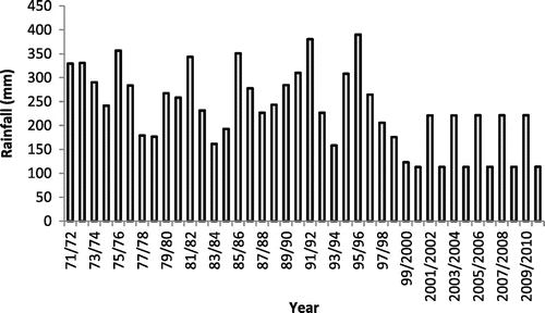
Rainy year: R > 250 mm
Dry year: 200 < R < 250 mm
Very dry year: R < 200 mm
3.2.2 Temperature
The steppe is characterised by quite a particular climate in general. Winters are harsh and very cold, with temperatures often dropping below 0°C. Frosts are quite common (40–60 days of frost per year, from October to May, at altitudes of over 900 m). This extreme cold is usually immediately offset by siroccos, which can raise the temperature up to over 40°C, to the other extreme. The temperature is strongly influenced by the altitude. This intensifies the frosts in winter while at the same time moderating temperatures in summertime Citation[16].
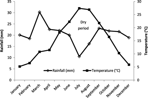
Table shows the changes in average monthly temperature of the El Bayadh region. The minimum temperature recorded during the month of January is 0.7°C. The maximum temperature peaks in July with an average of 35°C, characteristic of a continental climate. Figure shows the ombro-thermal diagram for the study area from the period 1971–2010. It can be seen that the dry period is very long; it stretches from the month of May to the month of October.
Table 3. Distribution of average monthly temperatures (Period: 1971–2010)
Fig. 3 Ombro-thermal diagram for the study area ‘‘El Bayadh” (1971–2010).
3.2.3 Wind
The Sirocco is the most damaging wind. It is a hot, dry wind blowing northwards from the Sahara. This wind blows for 20–30 days per year on the High Plains Citation[17]. The Sirocco can blow at any time of the year, but it is rare during the colder months, and blows mostly in July and August, causing thunderstorms. Its passage during the spring season destroys the crops ready to be harvested and scorches newly seeded fields. It precipitates the arrival of the summer and is dust-laden Citation[18]. Changes in maximum wind speeds in the region of El Bayadh in 2006/2007 are detailed in Table .
Table 4. Wind speeds in the wilaya of El Bayadh (Period: 2006/2007)
The dominant winds that are important to consider come from the north. Their average speed is 1.8 m/s. Frosts are common in this area and occur for an average of 44.1 days, occuring mainly in winter. Siroccos are present for 7 days per year.
3.3 Water availability and consumption
Hydrological considerations are critically important in determining the signs and magnitude of desertification Citation[19]. Therefore, the degree and severity of desertification can be determined through hydrological indicators Citation[20].
As regards drinking water, the importance of urban and rural centres, and high population growth imply high availability and consumption of water. In 2010, 82.84 h m3 of drinking water were consumed, which represented a rate of 20% (Table ). The province has a large dam at Brézina (in the south of the wilaya) with a capacity of 123 million m3. The dam is designed to irrigate an area of 1,200 ha and feed four small dams that are totally destroyed.
Table 5. Nature of water in the wilaya (This data is obtained from the National Agency for Hydraulic Resources of the wilaya of El Bayadh, NAHR, 2012)
3.4 Vegetation
Immediately after the independence of Algeria, reforestation was one of the urgent priorities in order to renew the forest heritage which suffered intense damage during the war of liberation.The work of the ‘‘green dam” project was begun in the early 1970s. This project involved a strip of land stretching from the western Algerian border to the eastern border, a distance of 1,500 km, with an average width of 20 km, and covering an area of 3 million ha Citation[21].
In the wilaya of El Bayadh the work implementing the ‘‘green dam” programme was begun in 1974 by young people on national service. Initially regarded as a vast forest curtain drawn against the advance of the desert, the actions of the ‘‘green dam” project focused primarily on the action of planting without any prior studies or trial projects on easier terrain, suitable for agricultural or pastoral use. The lack of studies carried out of the forest delimitation system and the lack of knowledge about the socio-economic situation caused the project to end in major failure and to result in consequent problems that are currently arising involving the integration of the wooded areas into the national forest area.
4 Conclusion
Desertification is accompanied by a reduction in the natural potential of the land, the depletion of surface and groundwater resources and negative repercussions on the living conditions and the economic development of the people affected by it. Furthermore, land degradation, in arid, semi-arid and dry sub-humid areas, means a reduction in or loss of the biological or economic productivity of rain-fed cropland, irrigated cropland, or rangeland, pasture, forest and woodland. It results from land uses, or from a process or combination of processes, including processes arising from human activities and habitation patterns.
The Algerian steppe has in recent years become the scene of an ecological and climatic imbalance. Intense degradation of this fragile environment resulting in desertification (through silting, wind erosion, overgrazing, land clearing, salinisation …) calls for a better understanding of how to combat it and adopt proper management practices.
The wilaya of El Bayadh has proven to be an area heavily threatened by desertification, where the scars and aftereffects are clearly visible. However, its climate is one of cold winters, with a maximum rainfall of 109.3 mm during the month of October. In this region, the maximum temperature is 35°C, recorded during the month of July, and the minimum temperature is around 0.7°C, in January.
In addition, we undertook this study based on the ecological indicators of the region (soil class, rainfall, temperature and wind) as well as the water resources and various reforestation programmes, specifically, the ‘‘green dam” project. It appears that the lack of rain and rising temperatures subsequently cause a lack of drinking water resources and scarce vegetation. Therefore, this evaluation conclusively shows that this region is classified as both an arid and semi-arid area vulnerable to desertification.
Related Research Data
References
- B.C. Bates, Z.W. Kundzewicz, S. Wu, J.P. Palutikof, Climate Change and Water, Technical Paper of the Intergovernmental Panel on Climate Change, IPCC Secretariat, Geneva, 2008, p. 210.
- M.K. Tolba, O.A. El-Kholy, E. El-Hinnawi, M.W. Holdgate, D.F. McMichael, R.T. Munn, The World Environment 1972–1992: Two Decades of Challenge. Chapman & Hall, London, 1992.
- A.A. Abahussain, A.S. Abdu, W.K. Al-Zubari, N. Alaa El-Deen, M. Abdul-Raheem, Desertification in the Arab Region: analysis of current status and trends. J. Arid Environ. 51 (2002) 521–545.
- A. Labani, Cartographie écologique et évaluation permanente des ressources naturelles et des espaces productifs dans la wilaya de Saida, Ph.D. Thesis, Sidi Bel Abbes University, 2005, p. 165.
- A. Ferrara, L. Salvatil, A. Sateriano, A. Nolè, Performance evaluation and cost assessment of a key indicator system to monitor desertification vulnerability. Ecol. Indic. 23 (2012) 123–129.
- M.V.K. Sivakumar, Interactions between climate and desertification. Agric. For. Meteorol. 142 (2007) 143–155.
- M.A.J. Williams, R.C. Balling, Interactions of Desertification and Climate, for WMO/UNEP. Arnold, London, 1996.
- H. Zhang, K. McGuffie, A. Henderson-Sellers, Impacts of tropical deforestation. Part II: The role of large scale dynamics. J. Clim. 9 (1996) 2498–2521.
- G. Zalidis, S. Stamatiadis, V. Takavakoglou, K. Eskridge, N. Misopolinos, Impacts of agricultural practices on soil and water quality in the Mediterranean region and proposed assessment methodology. Agric. Ecosyst. Environ. 88 (2002) 137–146.
- Y. Xue, J. Shukla, The influence of land surface properties on Sahel climate Part I: Desertification. J. Clim. 6 (1993) 2232–2245.
- K.A. McGuffie, A. Henderson-Sellers, H. Zhang, T.B. Durbidge, A.J. Pitman, Global climate sensitivity to tropical deforestation. Global Planet. Change 10 (1995) 97–128.
- M. Pouget, Les relations sol-végétation dans les steppes Sud-algéroises. Trav. Doc. ORSTOM., 116 (1980) 1–555. Originally published as State Doctorate Thesis (Doctorat d’Etat), Aix-Marseille University, 1979.
- U. Helldén, Desertification-time for an assessment? AMBIO 20 (8) (1991) 372–383.
- C. Töttrup, U. Helldén, Long term NOAA-AVHRR GIMMS-NDVI rainfall relationships and trends 1981 to 2003 for entire DeSurvey area of interest. Sub-deliverable 1.5.1.17 (1), EC, FP6, DeSuvey IP (Project No: 003950), 2007, 182 pp.
- U. Helldén, A coupled human-environment model for desertification simulation and impact studies. Global Planet. Change 64 (2008) 158–168.
- A. Cornet, La désertification: mobilisation de la communauté scientifique dans le cadre de la convention. Sciences et changements planétaires/Sécheresse 8 (1997) 85–86.
- Le Houérou, Climate change, drought and desertification. J. Arid Environ. 34 (1996) 133–185.
- Aidoud, Contribution à l’étude des écosystèmes pâturés (Hautes Plaines Algéro-Oranaises, Algérie), State Doctorate Thesis (Doctorat d’Etat), University of Sciences and Technology H. Boumediene, Algiers, 1989, p. 240.
- Y.A. Mageed, Anti-desertification Technology and Management. United Nations Environment Program, Nairobi, 1986 . p. 27.
- K.D. Sharma, The hydrological indicators of desertification. J. Arid Environ. 39 (1998) 121–132.
- M. Belaaz, Le barrage vert en tant que patrimoine naturel national et moyen de lutte contre la désertification. XII World Forestry Congress, Québec City, 2003.