
Abstract
The development of a holistic approach for the implementation of reuse strategies on vacant urban lands is essential if cities are to optimize the potential utility of these untapped resources as public amenity spaces, at a neighbourhood-, community- or city-wide planning scale. Many cities across the globe struggle with the presence of vacant and underutilized land in the urban environment. This is a wasted resource that has significant potential to contribute to a city’s green infrastructure/amenity capacity if the suitability of reuse strategies can be better understood. This paper presents a prototype community-based decision support tool to assist neighbourhood groups in completing a user-customizable vacant and underutilized land inventory at a neighbourhood, community or city-wide planning scale. The purpose of this research is to create an inventory that captures the relevant neighbourhood and site attributes in a way that can be conveyed to the user as a ‘site suitability index’ (or score). This information can then be used to make more informed decisions with respect to which parcels of vacant land are most suitable for temporary reuse strategies. Developed in Microsoft Excel®, the prototype tool allows the user to evaluate up to 15 community-based reuse strategies across three broad categories – parks, urban food production and stormwater/ecosystems management – using a hybrid binary scoring methodology. The prototype tool was applied to 25 sites across the City of Hamilton, Ontario, Canada, to determine the validity of the method presented. The inventoried attributes of (i) neighbourhood quality, (ii) developability potential, (iii) visual quality, (iv) compatibility, (v) transportation and (vi) vulnerable populations were used to calculate a set of site suitability indices. The indices calculated appeared appropriate for most uses, which validated the hypothesis that the majority of the inventoried sites would have strong indices based on the fact that they currently function as public amenity spaces.
1. Introduction
There is a renewed public policy focus in many jurisdictions with respect to intensifying existing, built-up urbanized areas through the use of vacant and infill lands (Ministry of Public Infrastructure Renewal Citation2006). Not only is it critical for municipal planners to determine where population and employment growth should occur, the provision for land uses that deliver active and passive parks and open space, urban food production, stormwater and ecosystems management functions will be of fundamental importance to sustaining urban growth. Mounting pressures related to population growth, natural resource stewardship, the urban heat island effect, poor urban air quality, reduced urban biodiversity, human health, an ageing population (Miller Citation2008), reduced access to healthy food for vulnerable populations (Grimm Citation2009; Hamilton Food Share Citation2009) and an anticipated growing demand for urban parks and open space (Poudyal et al. Citation2009) will require comprehensive strategies to effectively plan for and sustain productive, complementary urban landscapes for a growing population.
Many cities across the globe, regardless of size or geographic location, struggle with the presence of vacant and underutilized land in the urban environment; currently, long-term solutions that contribute to the recovery of declining areas have not been implemented on a consistent basis, if at all (Pagano & Bowman Citation2000). While all cities contain vacant and underutilized land, the location, supply and condition of this land can vary greatly. Central to the goal of reusing vacant and underutilized land for productive purposes (e.g. to stabilize declining neighbourhoods) is an understanding of the spatial distribution of these lands and the site suitability (i.e. site characteristics) for potential reuse strategies. It should be noted that the suitability of a plot of vacant land for reuse also depends on the strategic importance of that land in the development of the city, as well as the ownership of the land. Local decision-makers or land owners may be reluctant to allow certain forms of temporary reuse as it may create opposition from community stakeholders to allow the development of other urban land uses in the future.
Continuous productive urban landscapes (CPULs) is an ideology of what the urban form could look like if parks and open space elements (including underutilized lands) are connected with linear park, trail, open space, stormwater management and food production elements (Viljoen et al. Citation2005). Vacant and underutilized lands hold the potential to progressively build on the CPUL ideology and create, as Viljoen et al. (Citation2005) describe, loose-fit landscapes that are dynamic in use, aesthetic and ecological status. These spaces can also provide important cultural links, engaging diverse population groups that would not otherwise use a traditional park. Food urbanism, which is cantered on continuous productive landscapes, is an emerging concept that focuses on the relationship between food as infrastructure and the organization of a city and how through redesigning existing spaces food can transform the urban experience (Grimm Citation2009).
To take full advantage of vacant or underutilized land via the implementation of productive reuse strategies, it is critical that accurate site characteristics are identified (Pagano & Bowman Citation2000). While some vacant and underutilized lands may pose a human and environmental health risk in urbanized areas due to contaminated soil from past and/or present uses, Heinegg et al. (Citation2002) attempt to address this issue by providing a set of guidelines for physical and bio-remediation techniques for small-scale, community-based reuse projects, while Rideout (Citation2010) provides insight into best practices for urban agriculture on contaminated lands.
The spatial characteristics of a neighbourhood and the economic forces contributing to the growth or decay of neighbourhoods are also important for making well-informed land-use decisions. Voicu and Been (Citation2008) studied the effects of community gardens on nearby property values in New York and found that the greatest positive benefit was in the poorest of host neighbourhoods, where property values within 1000 feet of a garden increased by as much as 9% within five years of the garden being opened. Poudyal et al. (Citation2009) anticipate that there will be an increased demand for urban park acreage as urban populations continue to grow in cities across North America. Poudyal et al. (Citation2009) studied urban park benefits and found that an increase in parkland acreage of 20% would result in an increase in property values in the range of $6.5 million dollars, or $160/household in the study area. Masi (Citation2008) cites work completed by Ohio State University Extension, which estimates Cleveland’s community gardens, which cover 50 acres in total, generate between $1.2 and $1.8 million dollars worth of food annually.
There is a growing momentum, desire and basic need at a neighbourhood and community-based level for guidance in identifying the most appropriate location for the temporary reuse of vacant and underutilized urban land. There remains a fundamental challenge for neighbourhood groups to develop rehabilitation strategies that clarify the needs, goals and objectives of the community, define a range of appropriate strategies and a restoration time frame (Taylor Citation2000). Schilling and Logan (Citation2008) note that each vacant lot is unique, and as such each space will support specific opportunities. Rosenberg and Esnard (Citation2008) state that it is important to not lose sight of the need for transparent site selection models that can be presented to, and understood by, individuals in a public forum.
This paper contributes to the existing knowledge gap surrounding temporary urban land reuse, recognizing that an ultimate, higher-order land use may exist for presently idle vacant or derelict parcels of urban land. This paper presents a prototype decision support tool for inventorying the spatial characteristics of a neighbourhood and the physical site characteristics of a vacant or underutilized urban land parcel. The paper describes the development of site suitability indices (SSIs) based on a binary scoring methodology for a variety of green infrastructure land-use strategies. These indices can be used to compare the suitability of a given land use across the inventoried sites. It is believed that the decision support tool discussed within this paper will assist in clarifying the value and potential utility that certain lands hold for contributing to a neighbourhood’s green infrastructure capacity.
2. Methodology
2.1. Development of a prototype community-based planning tool
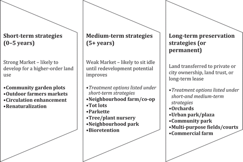
Building on the work undertaken by the Cleveland Land Lab at the Cleveland Urban Design Collaborative, Kent State University, and later adopted by the Cleveland City Planning Commission in 2008 (Cleveland Land Lab Citation2008), this paper introduces a prototype decision support tool for identifying the location and condition of vacant and underutilized land in the urban environment, and subsequently quantifying a SSI for a suite of 15 reuse strategies that contribute to a city’s green infrastructure capacity. The strategies cover three small-scale, neighbourhood-oriented categories: parks, food production and stormwater management/ecosystems management. Within these categories, the strategies have been divided into short-, medium- and long-term uses to reflect different classifications of market strength, with long-term uses indicating weak market potential and the likelihood that the land will continue to remain underutilized and undeveloped. It is believed that in using these spaces on an interim basis, municipal decision-makers will have the opportunity to test drive various uses across the urban environment and evaluate their social, economic and environmental utility, with the potential to later acquire these lands, making them permanent elements of the city’s green infrastructure inventory.
Prior to creating the prototype tool, a requirements document was compiled to address system capabilities, conditions and constraints, system operations and life cycle sustainment of the software product, with a primary focus on functional, technical, usability and maintainability requirements. The community-based self-assessment planning (C-SAP) tool, as the prototype tool will be known henceforth, is a scientific software product created using the Microsoft Excel® 2007 software platform. All macros were written in the built-in Visual Basic Editor (VBE), using the Visual Basic for Applications (VBA) programming language, and are executed via command buttons on the graphical user interface (GUI). The tool consists of a GUI (see ) that guides the user through completing a vacant and underutilized land inventory (VULI) and computing a set of SSIs for a suite of reuse strategies (see ). Consideration was given to the maintainability of the tool; as such, effort was taken to ensure that the majority of the variables were not hardcoded, but rather stored in spreadsheets, and made available to the user for alteration to suit their specific needs.
Figure 1. Screenshot of graphical user interface (GUI).
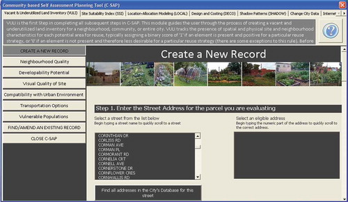
Figure 2. Strategies included in prototype decision support tool (adapted from Cleveland Land Lab Citation2008, Citation2009).
C-SAP utilizes neighbourhood, street, parcel, bus and statistics data. With reasonable effort and data substitution, this tool could be readily adapted to many jurisdictions across North America. To assist in this endeavour, the GUI guides the user through the process of copying new data into the built-in databases, providing colour-coded cells to differentiate between the changeable and non-changeable cells. Subject-specific, graphical help files have been included with the tool to assist the user in completing the inventory, while the user guide provides higher-level information to the user.
2.2. Potential applications of the developed tool
The decision support tool is useful for evaluating the addition or removal of existing green infrastructure/amenity elements at a neighbourhood-, community- or city-wide urban planning scale. It is the intention that this tool would also be useful in expediting application requests from community groups to lease city-owned lands for green infrastructure purposes as the output from the tool could potentially be included when making the initial request/contact with a city. Expediting the leasing process is critical when lands are being used on a temporary basis to maximize the usefulness and utility of the parcel and achieve the greatest benefits from a longer-term use. The output from C-SAP may assist in making the request process consistent, and the review process potentially more efficient, as the city staff member assigned to review the material would be familiar with the format and methodology employed for deriving the suitability indices, providing a certain level of confidence in the appropriateness of the request.
The following sections describe the development of the prototype VULI and provide rationale and support for the organization of the inventoried subcriteria into a structure consisting of six overarching umbrella criteria.
3. Theory
3.1. Vacant and underutilized land inventory
Rosenberg and Esnard (Citation2008) present a concise inventory and scoring methodology to determine suitable locations for transit stop site selection. Their work involved inventorying three umbrella criteria: proximity, developability and visual quality, and a series of subcriteria to identify the most suitable site for six potential transit locations (Rosenberg & Esnard Citation2008). This method was derived from Cutter et al.’s (Citation1997) method for calculating social vulnerability scores related to GIS-based hazard assessments. Mohajeri and Amin (Citation2010) use an analytic hierarchy (AHP) model with four umbrella criteria and 26 subcriteria to evaluate five potential candidate sites for transit site selection. Building on the above-noted methodologies, VULI presents a hybrid approach for selecting appropriate sites for vacant land reuse. These three applications capture a variety of spatial, social and land use attributes that assisted in developing the decision-making framework for VULI. Conveying the necessary information to decision-makers using a robust, yet transparent and readily understandable model was also common throughout these methods, and was deemed to be critical for VULI, designed with the assumption that it would be predominantly community-group-driven. An overview of the steps required to complete VULI is depicted in .
Figure 3. Flow diagram for completing the vacant and underutilized land inventory.
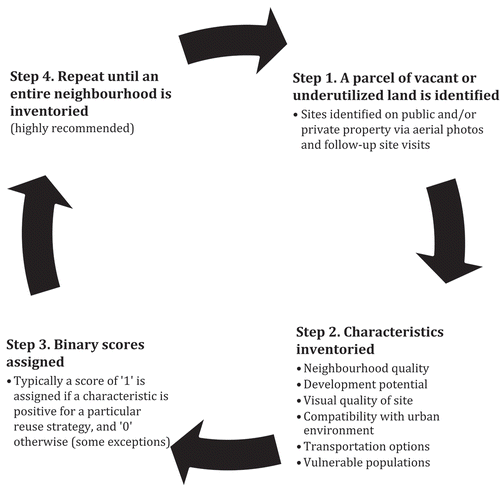
A three-stage research approach was undertaken during the development of VULI. Step 1 involved the completion of a literature review of existing inventories, neighbourhood qualities related to walkability, and relevant site selection characteristics for the suite of strategies included. During the process of this literature review, no software packages were discovered, community-based or otherwise, that attempt to quantify the site suitability for the strategies proposed herein. Step 2 of the research process involved the formulation of the umbrella criteria into six common categories identified in the literature: neighbourhood quality, developability potential, visual quality of the site, compatibility with the urban environment, transportation options and vulnerable populations, and the development of a set of subcriteria, summarized in –. The tables also depict the C-SAP default settings for the subcriteria. It is important to note that the user can customize the default settings to meet their needs by adding or removing questions from the inventory as desired. The architecture of the C-SAP system was developed to be intentionally transparent and adaptable by users. This was done to meet the broad needs of various user groups and jurisdictions by ensuring there is inherent flexibility in the system to select the criteria that they deem relevant.
Table 1. C-SAP default settings for neighbourhood quality subcriteria.
Table 2. C-SAP default settings for developability potential subcriteria.
Table 3. C-SAP default settings for visual quality of site subcriteria.
Table 4. C-SAP default settings for compatibility with urban environment subcriteria.
Table 5. C-SAP default settings for transportation options subcriteria.
Table 6. C-SAP default settings for vulnerable populations subcriteria.
Step 3 of the research process involved a review of the developed inventory framework by a group of eight professionals in the fields of engineering, parks planning, urban agriculture and urban planning and design. It is important to clarify that while the size and shading characteristics for each potential area for reuse are inventoried, these characteristics are not included in the umbrella criteria or subcriteria. Rather, the user is required to screen the appropriateness of evaluating each potential land use for each vacant parcel prior to initiating the inventory. In the following four sections, each of the umbrella criteria are highlighted, with a discussion of relevant supporting literature.
3.2. Umbrella criteria 1 and 3: neighbourhood quality and visual quality of site
Many planning policies place a strong emphasis on the urban design goals of creating quality spaces on public and private lands that are pedestrian-oriented, safe, accessible, connected, transit-supported, compatible with and enhancing to surrounding uses, and adaptable and flexible to accommodate future demographics and changing environments. Established in 2005, the National Complete Streets Coalition define ‘Complete Streets’ as a movement that focuses on delivering a street network that is safe, convenient, comfortable and accessible for users regardless of their age or abilities, and regardless of their mode of transportation (Smith et al. Citation2010). This paper presents an accountable strategy for community leaders to pursue the Complete Streets movement in a complementary and compatible way through the reuse of vacant and underutilized urban land for productive, community-centred, active and passive purposes. In effect, the planning tools (VULI and SSI) presented herein focus on streetscapes and filling in urban ‘gaps’ in the landscape with the objective of creating accessible, safe, robust and stable neighbourhoods.
A variety of sources were utilized to inform the selection of the neighbourhood and visual quality criteria for green infrastructure site selection. Core urban planning principles were identified and recorded during the literature review summarized below. Spatial and physical attributes that were identified in at least three separate sources were selected as subcriteria and questions were subsequently formulated to capture and articulate each attribute. A growing body of literature on the topic of pedestrian and neighbourhood audit tools has been developed over the last decade in an effort to aid urban planning and design professionals in decisions that impact, improve and complement the urban form. Ewing and Handy (Citation2009) present a methodology for measuring physical qualities of the urban street environment, including imageability, enclosure, human scale, transparency and complexity. Clifton and Livi (Citation2004) wrote an audit protocol for a tool known as the Pedestrian Environment Data Scan (PEDS), which measures environment, pedestrian facility, road attributes and walking and cycling environment. Alfonzo et al. (Citation2005) propose a method for inventorying physical environment features linked to physical activity, including attractiveness, land uses, roadways, buildings and lighting. The San Francisco Department of Public Health (Citation2008) developed a Pedestrian Environment Quality Index Survey that involves inventorying intersections, streets, sidewalks, land uses and safety. Saelens et al. (Citation2003) present a scoring procedure known as Neighbourhood Environment Walkability Scale (NEWS) whereby they linked walkability to residential density, land-use mix, street connectivity, walking and cycling facilities, aesthetics, safety and general neighbourhood satisfaction. The predominant themes in each of these tools were extracted and used in the development of the subcriteria for both neighbourhood and visual quality criteria of the site.
3.3. Umbrella criterion 2: developability potential
The potential that a site holds for development on a temporary basis is a significant criterion when deciding how to spatially allocate reuse strategies across the urban landscape. To complete this section of VULI, the user is required to inventory a series of high-level characteristics with respect to the site conditions, loosely defining the likelihood of development based on larger material, time and labour requirements for a specific use. Several key documents were used to develop the scope of the subcriteria. These include the work completed by the Cleveland Land Lab (Citation2008, Citation2009) for vacant land reuse, which provides detailed recommendations for site selection for a variety of strategies including parks and urban food production uses, the work presented by Dow (Citation2006) and Heinegg et al. (Citation2002), which addresses barriers to implementing community gardens, a municipal community garden policy (Hamilton Citation2010), which addresses capital costs and considerations when building city-supported community gardens, the work of Burkholder et al. (Citation2007), which addresses urban agriculture site development, the City of Hamilton Official Plan (Citation2009a), which provides a broad set of principles for parkland design, and the work of Mendes et al. (Citation2008), which evaluated the use of land inventories for the identification of suitable locations for urban food production.
3.4. Umbrella criteria 4 and 5: compatibility with urban environment and transportation options
Compatibility with the surrounding urban environment is identified in municipal policy documents as a fundamental design goal for the development of all new public and private spaces (Hamilton Citation2009a). Drawing on the work of Brown and Carter (Citation2003), Hohenschau (Citation2005) and municipal planning policy (Hamilton Citation2009a), a selection of 11 synergistic, complementary land uses were identified and included in VULI (see ). Built-in databases of geocoded, compatible land parcels are required for the decision support tool.
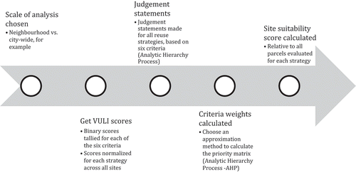
Figure 4. Flow diagram for calculating the site suitability index.
Transportation options are also important in determining appropriate reuse strategies for vacant and underutilized land. Site accessibility via sidewalks, recreational trails, transit and on-street bike routes are important to the successful and ongoing use and stewardship of the green infrastructure strategies included in the C-SAP tool. The City of Hamilton Official Plan Policy (Citation2009a) states that transit stops should be in close proximity and adjacent to, where possible, community facilities including parkland. Hohenschau (Citation2005) echoes the need for transit access for urban food production systems, further noting that high visibility is particularly important for community farms and co-ops.
3.5. Umbrella criterion 6: vulnerable populations
For the purposes of this research, vulnerable populations include persons who live in rental units and/or apartment building units (less access to private amenity spaces), ageing populations (65+ years of age), low-income persons and at-risk youth. The World Health Organization has been promoting the creation and retrofit of cities to ensure they are age-friendly, a need well understood in Canada, as one in four Canadians will be considered a senior citizen in 25 years (Miller Citation2008). From a parks planning perspective, municipalities are also recognizing the need to design parks for a diverse and changing demographic (Hamilton Citation2009a). In the United States, it is reported that there are twice as many urban food gardeners over the age of 65 when compared with those under the age of 35, and they recognize a demand for low-income families to acquire garden space to grow their own vegetables (Brown & Carter Citation2003). The movement to convert lands on, and in close proximity to, non-profit housing is also taking hold (Hamilton Citation2010). Hohenschau (Citation2005) states the importance of targeting multifamily housing, where there is little or no growing or amenity space, as well as youth as a key consideration when locating garden plots and amenity spaces. Statistical (census) data are required in the C-SAP tool for vulnerable populations to determine the relative vulnerability of the user-specified vulnerable population immediately surrounding the subject site.
The user has the flexibility to choose which of the 44 subcriteria are included in the inventory process for each potential land use; however, at least one subcriterion must be chosen for each umbrella criterion. This is required as the user cannot enter a weight of zero for any of the umbrella criteria weights when using the AHP as this method uses a reciprocal matrix method, requiring non-zero entries. The following section describes the methodology for generating a matrix of SSIs for the evaluated reuse strategies across all, or a subset of, the inventoried sites.
3.6. Site suitability indices
The steps required for completing the matrix of SSIs are depicted in . To calculate the SSIs, the binary scores for each subcriterion are identified and summed from the inventory process (VULI). Typically, if a subcriterion is present, a score of 1 is assigned; otherwise, a score of 0 is applied. These values are then normalized, based on the best performing site for each criterion, for each potential land use, which produces a matrix of relative scores that is presented out of 100. Criterion weights are determined using the AHP. Developed by Thomas Saaty, the AHP is described in detail in many other written works (Saaty Citation1977, Citation1990; Palcic & Lalic Citation2009), with applications in a broad range of disciplines that span several decades. AHP assists in decision making by clarifying the importance of each criterion using a set of pairwise comparisons, or judgement statements, of the umbrella criteria (Saaty Citation1977). The idea behind AHP is to construct a matrix that expresses the relative values of a set of criteria. For example, given a particular land use, what is the relative importance of the compatibility of the land use with the urban environment as opposed to the relationship between the land use and the quality of the neighbourhood? Users of C-SAP are asked to choose whether a criterion, in comparison to a competing criterion, is equally important, strongly more important, strongly less important, moderately more important, moderately less important and so on. Each of these judgements is assigned a number on a scale (Saaty Citation1977). In C-SAP, a unique set of judgement statements can be entered for each potential land use or statements can be completed on a subset of strategies. The user repeats this process until judgement statements have been made for all strategies under analysis. In all evaluated scenarios discussed within this paper, a single set of judgement statements is applied to the entire set of evaluated reuse strategies. The consistency ratios (CRs) for each set of judgement statement have been included in , all of which are within acceptable limits of 0.0–0.1 (Saaty Citation1990), indicating that the judgement statements made are deemed to be consistent (zero being perfectly consistent). Four sets of judgement statements were completed, generating four unique sets of umbrella criteria weights for each of the two applications discussed below (see ). These sets of weights were subsequently used to assess the sensitivity to changes in the umbrella criteria weights and the resulting SSIs for the inventoried sites. The methodology used for completing the judgement statements and calculating the umbrella criteria weights is described in detail in Saaty (Citation1977). From the calculated criteria weights, the normalized relative scores are aggregated, resulting in a set of relative SSIs for each potential land use across all inventoried sites. It is important to note that while SSIs inherently hold no meaning when evaluated in isolation from the entire set of indices, they provide valuable information when compared and discussed relative to the indices across all inventoried sites for the corresponding land use of interest. The decision support tools described within this paper (VULI and SSI) do not assign a ‘best use’ to a vacant site; rather, they provide the user with a series of SSIs for a particular land use across all inventoried vacant or underutilized sites. Kirnbauer and Baetz (Citation2012) introduce an augmented capacity to C-SAP for allocating land uses to vacant sites based on a series of user-specified constraints and a binary integer program formulation.
Table 7. Judgement statement for scenarios 1–4.
Table 8. Normalized umbrella criteria weights.
4. Results and discussion
4.1. Applications of the prototype decision support tool
As part of verifying the appropriateness of the scoring, weighting and aggregation methodology employed in C-SAP, two applications of the developed tool were analysed. A discussion of the two applications of C-SAP follows; the first application involved applying C-SAP to 13 existing community garden and neighbourhood farm locations in the City of Hamilton, Ontario, while the second application of the tool involved applying C-SAP more broadly to include two existing sites for each remaining land use (with the exception of orchards, renaturalization, bioretention and nurseries as there are currently no examples of vacant or underutilized land having been converted to these uses within urban Hamilton). The vulnerable population evaluated in all applications of the tool was the percentage of persons living in apartment buildings due to their lack of backyard amenity space. All sites were pre-screened for sunlight characteristics and size – a value of ‘n/a’ in and indicates that the site was deemed to be inappropriate for the corresponding use during the pre-screening assessment. Sites that were not located on a corner or through-lot, providing increased circulation options for pedestrians and cyclists, were not considered for circulation enhancement. Google Maps (using satellite imagery and ‘Street View’) was used in both applications to verify many of the site and neighbourhood characteristics for the locations assessed. This process was later augmented with site visits in situations where these characteristics were poorly understood or unfamiliar.
For all sites analysed in both applications, it was observed that a SSI in the range of 60–100 was achieved for virtually all existing uses (with the majority of these being between 70 and 100). The sites where the site suitability appeared to be less favourable could be linked to specific neighbourhood or site characteristics. Prior to completing this analysis, it was predicted that sites would score reasonably well as they are currently being used as green infrastructure/amenity spaces across the city, a prediction that appeared to be validated during the evaluation of the output. It is apparent from this analysis that there are several potential land uses that are reasonably close to the highest site suitability score for any given land use in both applications. The tool is useful in articulating the strengths and weaknesses of sites by allowing the user to view two output tables: (i) the six umbrella criteria scores for each potential land use or (ii) the aggregated SSIs for each land use. It is important to recognize that the suitability indices are not intended to provide the user with a definitive answer with respect to the assignment of a land use, but rather a means of assisting a user in clarifying the relative suitability of a site for a particular land use so that they can make better informed decisions. SSIs were calculated for all sites based on the four judgement statement scenarios located in . To conserve space, the output from scenario 4, which placed a strong importance on the developability potential and visual quality of the site (a total weight of 55%), is discussed in detail below. The output from scenarios 1, 2 and 3 produced similar results for the best performing sites when compared with scenario 4, which is indicative of the robustness of the umbrella criteria scores for the best performing sites.
4.2. Application 1: existing community garden and neighbourhood farm locations
Thirteen community garden and neighbourhood farm locations were inventoried across 11 neighbourhoods in the City of Hamilton, based on the most current community garden directory provided by the City of Hamilton (Citation2009b). The SSIs for scenario 4 were subsequently calculated by C-SAP and are presented in . The index for the current use on each site has been shaded in grey. As the majority of the inventoried sites currently function at full capacity as community gardens, it was anticipated that these sites would score reasonably well in terms of site suitability. Sites 1, 2, 5, 7, 8, 11, 12 and 13 have relatively high-site suitability scores for all urban food production uses (strategies 1 through 5), with judgement statement scenario 4 having slightly higher values when compared with scenario 1 (due to the weights applied to the umbrella criteria). Sites 3, 4, 6, 9 and 10, however, have relatively low-site suitability scores for all potential reuse strategies, which may be indicative of their overall lack of suitability for all uses. A review of the umbrella criteria scores provided clarification with respect to the lower suitability indices for these five sites.
Table 9. Site suitability indices for application 1.
Sites 9 and 10 (located directly beside each other in a low-density neighbourhood) did not function at full capacity in 2010; there was space for 100 garden plots at site 10; however, only 50 were used (B. Wilcox, personal communication, 9 July 2010). The neighbourhood farm (site 9) also produced less produce for the food bank in 2010 when compared with previous years due to a reduction in volunteer participation (B. Wilcox, personal communication, 9 July 2010). The sites scored low in the following criteria for both urban farms and community gardens: neighbourhood quality (33), visual quality of the site (50), compatibility with the urban environment (43), transportation options (50) and vulnerable population (8). Centre Paradise Gardens (site 4) is located in Hamilton’s industrial north end, directly across the street from a brewery. While this is a generally successful site for gardening in terms of participation rates, the site had low relative scores for visual quality of the site (0), compatibility with the urban environment (29), transportation options (25) and vulnerable population (33). Keith Neighbourhood Gardens (site 6) is located approximately 650 m southeast of site 4. The site scored low for community gardens in relative neighbourhood quality (50), compatibility with urban environment (43), transportation options (25) and proximity for vulnerable populations (33). While sites 4 and 6 scored relatively low, these gardens maintain high participation rates, revealing that these spaces provide utility to citizens. However, the developed decision support tool may be useful in locating sites that provide even greater utility for a community. Today’s Family Shared Garden (site 3) has the potential to expand to twice the current productive space. This site scored low in neighbourhood quality (33), visual quality (25), compatibility with urban environment (43), transportation options (25) and vulnerable population (3), and it is believed that this is indicative of the less-than-optimal participation rates.
Regardless of the judgement statement scenarios, and the resulting priority matrices, site 11 was identified as being the most suitable site for virtually all uses. Site 11 is a large, multipurpose community park located in a mixed-use, high-density area, and scored extremely high in all six umbrella criteria. As such, it was anticipated that it would have high-SSIs for virtually all reuse strategies. This was confirmed upon review of the C-SAP output.
Due to the fact that identical judgement statements were made for all land uses in each of the four evaluated scenarios, the indices for each land use typically followed a similar pattern in terms of the ranking of site suitability scores for each land use. It is not anticipated that this would occur if individual judgement statements had been made for each land use under consideration.
4.3. Application 2: existing urban plaza, parkette, community park, neighbourhood park, circulation enhancement/tot-lot and farmers’ market locations
In the second application, C-SAP was applied to 12 existing sites to validate the output for a broader range of reuse strategies: two urban plazas, two parkettes, two community parks, two neighbourhood parks, two circulation enhancement features/tot-lots and two farmers’ markets. Sites 7 and 11 each serve a dual function as both a tot-lot and a circulation enhancement feature. Sites 4 and 8 are hardscaped, actively used parking lots that were deemed to be suitable only for farmers’ markets. To conserve space, the output for scenario 4 is shown in . The grey-shaded areas correspond to the site suitability scores for the existing use on the site.
Table 10. Site suitability indices for application 2.
While there are no existing orchards or commercial farming operations in the City of Hamilton, sites 1, 2, 9 and 10 appear to be suitable locations, scoring close to 80 for both uses. There are no existing uses of vacant land in the city for nurseries, bioretention or renaturalization; however, site 1 appears to be most suitable for nurseries and bioretention strategies, while sites 9 and 10 appear to be most suitable for renaturalization. Site 8, an existing farmer’s market, scored high in all umbrella criteria, resulting in the largest site suitability score (93) for this land use. Site 4 had lower vulnerable population, transportation, visual quality of the site and compatibility with the urban environment scores, resulting in a site suitability score of 71. Site 8 is located on a collector road in the heart of a mixed-use, highly visible, highly travelled area, while site 4 is located in a rear parking lot, set back from an arterial roadway, with less visual quality, fewer pedestrians passing by and fewer overall surrounding compatible uses. It should be noted that both farmers’ market locations are successful sites with respect to patronage, which may be indicative that a land use is suitable if its corresponding suitability index is in the order of 70 or greater. This validates the results obtained from application 1. Sites 7 and 11, both functioning as circulation enhancement features and tot-lots, had lower SSIs (59–73). The output from C-SAP reveals that site 7 may be more suitable for renaturalization, while site 11 appears to be equally suitable for all reuse strategies, with the exception of plant nurseries and bioretention features. Sites 2 and 10, both community parks, had generally strong suitability indices (73 and 78, respectively), indicating that the existing uses are generally well suited at both of these locations. This is validated by the observed patronage at both of these locations. While scoring well for their existing uses, it should be noted that sites 2 and 10 have a variety of other reuse strategies that appear to be suitable alternatives. Site 3, an existing parkette, scored lower than seven of the SSIs for this use on alternative sites, while site 12 had the third highest suitability index for a parkette across all evaluated sites. Located on a multilane collector road, close to a busy downtown intersection, site 3 scored lower in neighbourhood quality and visual quality of the site. Sites 1 and 5, both urban plazas, scored notably different. Site 1, a 1.7-acre downtown urban plaza, scored very strongly in terms of site suitability, while site 5 scored distinctly lower due to its compatibility with the urban environment (57), transportation options (50) or proximity to vulnerable populations (25). The largest SSI for neighbourhood parks (79) corresponds to site 9, which is an existing neighbourhood park. Site 6, also an existing neighbourhood park, had a slightly lower suitability index (73), scoring particularly low in neighbourhood quality and transportation criteria scores.
Overall, application 2 results validate the results from application 1, echoing that suitability indices between 70 and 100 appear to be strong indicators of the general suitability of a particular land use. With the exception of site 7, discussed above, all existing sites evaluated in application 2 resulted in suitability indices greater than 70. It was anticipated that the indices would be generally high due to the fact that the inventoried sites are all existing sites within the city’s green infrastructure inventory, and as such lend themselves to alternative green infrastructure reuse strategies. It is apparent from the review of the four criteria weight scenarios, described in and , that different weights can have a significant impact on the SSIs, and as such, users should be prudent in making judgement statements that reflect their values and preferences. While the tool is useful in clarifying the relative suitability of reuse strategies across vacant lands, there are several limitations of this methodology that are identified and addressed below.
4.4. Limitations of methodology
Rosenberg and Esnard (Citation2008) discuss several limitations related to their site inventory process that are relevant to the VULI described herein. First, the user is required to make inherently subjective yes/no statements in VULI with respect to neighbourhood and site characteristics, and as such the output could vary between users of the tool. Efforts have been made to reduce this subjectivity by providing visual help files to guide the user inputs. Further, efforts were made to formulate the questions in a way that focused on inventorying the physical characteristics, with fewer open-ended questions about user perceptions (such as the ‘quality of the space’). It is strongly recommended, for consistency, that the same user or community group complete the entire inventory for a particular neighbourhood. Second, to reveal a more accurate picture of site suitability, it is strongly recommended that the user include a site in the inventory that has strong characteristics across all six criteria, and that they complete a comprehensive inventory at the minimum scale of the neighbourhood level, to minimize the chance that the indices are over-inflated. Third, correlations between the six umbrella criteria (and subcriteria) were not addressed as this was considered to be beyond the scope of this research. It should be noted, however, that studying the relationship between the criteria as part of a future research project could provide valuable insight into further refining the VULI. Lastly, due to the fact that the SSIs are relative to the best performing site for a particular use, conclusions cannot be drawn with respect to the best land use for a single site using SSIs in isolation of the other tools provided in C-SAP (e.g. a user cannot state ‘community gardens are most suitable for site 1 when compared with all other uses evaluated’); rather, statements can be made with respect to evaluating site potential for a particular land use (e.g. ‘community gardens had the highest site suitability index at site 1 when compared to community gardens at all other sites’). Kirnbauer and Baetz (Citation2012) address this issue and assist users in carrying out location-allocation analyses to obtain the maximum utility across the desired planning scale, based on user-specified, adjustable constraints such as the (i) maximum number of each type of land use desired, (ii) minimum distance between each classification of use, (iii) minimum residential density required to support each use, (iv) minimum and maximum site area requirements to support each use and (v) sunlight penetration. Costs for land rehabilitation and land-use implementation were not included in the modules described within this paper in an attempt to avoid prematurely eliminating alternatives as there is a precedent in several Canadian jurisdictions for private and public sector donations. Kirnbauer and Baetz (Forthcoming Citation2014) introduce augmented capacity to C-SAP in the form of a site design and life cycle costing tool, based on a variety of materials and maintenance frequency alternatives, to evaluate the costs associated with user-specified designs and determine the feasibility of land-use implementation.
5. Concluding remarks
This paper introduces a prototype decision support tool (C-SAP) for identifying and inventorying the location and condition of vacant and underutilized land across the urban environment. The tool subsequently evaluates the site suitability of 15 reuse strategies across three small-scale, neighbourhood-oriented categories: parks, food production and stormwater management/ecosystems management. Using C-SAP, 44 subcriteria are inventoried and organized into six umbrella criteria. The umbrella criteria are assigned weights and the relative subcriteria scores are aggregated and presented as a set of SSIs for each land use across the inventoried sites. This information can then be used by community groups or municipal decision-makers in determining which sites are most suitable for reuse based on their developability potential, neighbourhood and site quality, compatibility with the surrounding urban environment, accessibility potential and proximity to vulnerable populations. The decision support tool was applied to 25 existing sites in the City of Hamilton to evaluate the appropriateness of the methodology employed. The majority of the sites evaluated had relatively strong site suitability scores for their intended use. This result was generally anticipated prior to completing the analyses as these sites are currently being used as public amenity spaces, and therefore these analyses were in essence a validation exercise. The process described within this paper for determining site suitability is believed to be a useful and informative process in the analysis of vacant and underutilized land, helping to articulate and quantify the inherent potential of these spaces for future reuse.
Funding
This work was supported by the Natural Sciences and Engineering Research Council of Canada and the Department of Civil Engineering, McMaster University.
Notes
1. The underlying research materials for this article can be accessed at http://www.eng.mcmaster.ca/civil/sustain/downloads.html
References
- Alfonzo M, Day K, Boarnet M. 2005. Irvine Minnesota inventory for observation of physical environment features linked to physical activity (training protocol) [Internet]. [cited 2011 Mar 10]. Available from: https://webfiles.uci.edu/kday/public/index.html
- Brown KH, Carter A. 2003. Urban agriculture and community food security in the United States: farming from the city centre to the urban fringe [Internet]. [cited 2011 Mar 2]. Available from: http://www.foodsecurity.org/PrimerCFSCUAC.pdf
- Burkholder G, Ng P, Niu J, Solanki A. 2007. Growing gardens: a resource package on how to start your own garden [Internet]. [cited 2011 Feb 4]. Available from: http://www.spec.bc.ca/Resources/Documents/Food/Growing-Gardens-Manual.pdf
- City of Hamilton. 2009a. Urban Hamilton Official Plan: vibrant, healthy, sustainable Hamilton [Internet]. [cited 2011 Jan 21]. Available from: http://www.hamilton.ca/CityDepartments/PlanningEcDev/Divisions/StrategicServicesSpecialProjects/Policy+Planning/HamiltonNewOfficialPlan/UrbanHamiltonOfficialPlan.htm
- City of Hamilton. 2009b. Hamilton community garden directory [Internet]. [cited 2011 Jan 22]. Available from: http://hcgn.ca/garden-directory/
- City of Hamilton. 2010. Community garden policy (PW10044) [Internet]. [cited 2011 Jan 22]. Available from: http://www.hamilton.ca/NR/rdonlyres/F8B4672C-6E0D-4A5B-8A52-C2556C7914B7/0/Apr19EDRMS_n86758_v1_7_1__PW10044.pdf
- Cleveland Land Lab. 2008. Re-imagining a more sustainable Cleveland: citywide strategies for reuse of vacant land [Internet]. [cited 2011 Apr 17]. Available from: http://www.cudc.kent.edu/projects_research/research/reimagining_cleveland.html
- Cleveland Land Lab. 2009. Re-imagining Cleveland: vacant land reuse pattern book [Internet]. [cited 2011 Apr 17]. Available from: http://www.cudc.kent.edu/projects_research/research/reimagining_cleveland.html
- Clifton KJ, Livi AD. 2004. Pedestrian Environment Data Scan (PEDS) audit protocol [Internet]. [cited 2011 Apr 3]. Available from: http://kellyjclifton.com/?page_id=38
- Cutter SL, Mitchell JT, Scott MS. 1997. Handbook for conducting a GIS-based hazards assessment at the county level [Internet]. [cited 2011 Apr 3]. Available from: http://training.fema.gov/EMIWeb/edu/docs/hrm/Session%206%20-%20Handbook%20GIS-Based%20Hazards%20Assessment.pdf
- Dow CL. 2006. Benefits and barriers to implementing and managing well rooted community gardens in Waterloo Region, Ontario [Master’s thesis] [Internet]. [cited 2011 Feb 18]. Available from: http://www.cityfarmer.org/WaterlooDowCG.html
- Ewing R, Handy S. 2009. Measuring the unmeasurable: urban design qualities related to walkability. J Urban Design. 14:65–84. doi:10.1080/13574800802451155
- Grimm J. 2009. Food urbanism: a sustainable design option for urban communities [Internet]. [cited 2011 Apr 21]. Available from: http://johnsonlinn-localfood.webs.com/Planning%20Resources/Food%20Urbanism_Grimm.pdf
- Hamilton Food Share. 2009. Hamilton hunger count 2009 [Internet]. [cited 2011 Jan 22]. Available from: http://www.hamiltonfoodshare.org/downloads/Hunger_count_Report_2009__final.pdf
- Heinegg A, Maragos P, Mason E, Rabinowicz J, Straccini G, Walsh H. 2002. Soil contamination and urban agriculture: a practical guide to soil contamination issues for individuals and groups [Internet]. [cited 2011 Mar 26]. Available from: http://mse-research.mcgill.ca/envr401_2002/brownfields/guide.pdf
- Hohenschau D. 2005. Community food security and the landscape of cities [Master’s thesis] [Internet]. [cited 2011 Jan 18]. Available from: https://circle.ubc.ca/handle/2429/16818
- Kirnbauer MC, Baetz BW. 2012. Allocating urban agricultural reuse strategies to inventoried vacant and underutilized land. J Environ Informatics. 20:1–11. doi:10.3808/jei.201200215
- Kirnbauer MC, Baetz BW. Forthcoming 2014. Prototype decision-support system for designing and costing municipal green infrastructure. J Urban Plann Dev. doi:10.1061/(ASCE)UP.1943-5444.0000191
- Masi B. 2008. Defining the urban-agrarian space. In: Rugare S, Shwarz T, editors. Cities growing smaller (Urban Infill Volume 1). Kent (OH): Kent State University.
- Mendes W, Balmer K, Kaethler T, Rhoads A. 2008. Using land inventories to plan for urban agriculture: experiences from Portland and Vancouver. J Am Plann Assoc. 74:435–449. doi:10.1080/01944360802354923
- Miller G. 2008. Inclusive design must be integrated with drive for sustainability. Ontario Plann J. 23:6–7.
- Ministry of Public Infrastructure Renewal. 2006. Places to grow: growth plan for the Greater Golden Horseshoe [Internet]. [cited 2011 Jan 12]. Available from: https://www.placestogrow.ca/index.php?option=com_content&task=view&id=9&Itemid=14
- Mohajeri N, Amin GR. 2010. Railway station site selection using analytical hierarchy process and data envelopment analysis. Comput Ind Eng. 59:107–114. doi:10.1016/j.cie.2010.03.006
- Pagano MA, Bowman AO’M. 2000. Vacant land in cities: an urban resource [Internet]. [cited 2011 May 21]. Available from: http://www.mrsc.org/artdocmisc/paganofinal.pdf
- Palcic I, Lalic B. 2009. Analytical hierarchy process as a tool for selecting and evaluating projects. Int J Simul Modell. 8:16–26. doi:10.2507/IJSIMM08(1)2.112
- Poudyal NC, Hodges DG, Merrett CD. 2009. A hedonic analysis of the demand for and benefits of urban recreation parks. Land Use Policy. 26:975–983. doi:10.1016/j.landusepol.2008.11.008
- Rideout K. 2010. Urban agriculture: issues for public and environmental health [Internet]. [cited 2011 May 11]. Available from: http://www.slideshare.net/NCCEnvHealth/urban-agriculture-issues-for-public-and-environmental-health
- Rosenberg JL, Esnard A-M. 2008. Applying a hybrid scoring methodology to transit site selection. J Urban Plann Dev. 134:180–186. doi:10.1061/(ASCE)0733-9488(2008)134:4(180)
- Saaty TL. 1977. A scaling method for priorities in hierarchical structures. J Math Psychol. 15:234–281. doi:10.1016/0022-2496(77)90033-5
- Saaty TL. 1990. How to make a decision: the analytic hierarchy process. Eur J Operational Res. 48:9–26. doi:10.1016/0377-2217(90)90057-I
- Saelens BE, Sallis JF, Black J, Chen D. 2003. Neighborhood-based differences in physical activity: an environment scale evaluation. Am J Publ Health. 93:1552–1558. doi:10.2105/AJPH.93.9.1552
- San Francisco Department of Public Health. 2008. The Pedestrian Environmental Quality Index (PEQI): an assessment of the physical condition of streets and intersections (Draft Report) [Internet]. [cited 2011 Apr 7]. Available from: http://www.sfphes.org/component/jdownloads/summary/20-peqi/104-pedestrian-environmental-quality-index-peqi-an-assessment-of-the-physical-condition-of-streets-and-intersections?Itemid=62
- Schilling J, Logan J. 2008. Greening the rust belt: a Green infrastructure model for right sizing America’s shrinking cities. J Am Plann Assoc. 74:451–466. doi:10.1080/01944360802354956
- Smith R, Reed S, Baker S. 2010. Street design: Part 1 – complete streets. Public Streets. 74:12–17. FHWA-HRT-10-004
- Taylor R. 2000. Strategies for restoring vacant land: an analysis of northeast cities with recommendations for New Haven [Internet]. [cited 2011 May 9]. Available from: http://www.yale.edu/uri/pubs/WP/WP_46.html
- Viljoen A, Bohn K, Howe J. 2005. CPULs: continuous productive urban landscapes. New York: Elsevier.
- Voicu I, Been V. 2008. The effect of community gardens on neighboring property values. Real Estate Econ. 36:241–283. doi:10.1111/j.1540-6229.2008.00213.x