
ABSTRACT
Urban green spaces and trees provide multiple benefits to urban residents and the sustainability of cities. A poorly examined benefit is the provision of fodder to urban livestock. However, the presence and activities of livestock may be incompatible with other uses, although this has been little studied. We examined the impacts of livestock on trees and parks along a gradient of declining livestock density, complemented with a tree planting experiment to monitor damage. Neighbouring residents and park managers were interviewed regarding their perceptions of damage caused by livestock. The negative impacts on soil compaction, tree damage and death increased with increasing livestock densities. Thorny tree species were damaged significantly less (13 %) than non-thorny species (77 %), as were protected trees (25 %) relative to unprotected ones (65 %). There was more tree damage in public green spaces (PUGS) (54 %) than control sites (38 %). The majority of local residents felt that livestock should not be allowed in formal PUGS, and most urban park managers regarded livestock damage as a strong disincentive to plant trees. These results show the need for management of the trade-offs caused by livestock and greater appreciation of livestock as agents shaping aspects of PUGS.
1. Introduction
Urban green spaces and trees provide a variety of ecosystem services to urban residents (Young Citation2010; Roy et al. Citation2012; Mundoli et al. Citation2015). Indeed, the multi-functionality of urban green spaces and trees is the core tenet of the ‘green infrastructure’ concept (Sandström Citation2002; Wright Citation2011; Albert & van Haaren Citation2014; Hansen & Pauleit Citation2014). However, promoting multi-functionality is often fraught because different stakeholders prioritise distinct services, leading to potential or real incompatible uses or conflicts of interests.
Such a conflict potentially arises from the presence of livestock in urban green spaces. This is a common feature of many developing country towns and cities, where livestock are held for food, cultural or economic reasons (Lee-Smith Citation2010). For example, over 70% of households in Dar es Salaam, the capital city of Tanzania, have livestock (Halloran & Magid Citation2013), compared with 30% in a part of Bengaluru (India) (Mundoli et al. Citation2015). Indeed, this facet is a core attribute that differentiates the planning and practice of urban forestry and greening in many developing countries relative to developed ones (Shackleton Citation2012). Owners of urban livestock need to locate sufficient forage and browse on a daily basis to support their animals. They may buy food, collect it by hand and carry it to where their livestock are housed, herd livestock to formal and informal green spaces or fields, or let them free-range seeking food wherever they can (Amadou et al. Citation2012). The latter two foraging activities may lead to grazing of the herbaceous layer of formal and informal green spaces or the browsing or lopping of leaves and branches from urban trees. Pressures exerted by livestock can be high in urban settings because the area of green space available is often insufficient relative to the number of livestock needing to be supported (Fabricius et al. Citation2004) and is in a constant state of flux as infrastructure developments encroach on green areas (Mundoli et al. Citation2015). In investigating the damage to newly planted street trees in small towns in South Africa, Richardson and Shackleton (Citation2014) interviewed local residents living nearby to where some trees had been damaged and found that almost half of them had seen urban livestock damaging the trees.
The compatibility between urban livestock and urban greenery and trees has rarely been examined. For example, in the 12 years since one of the leading journals in the urban forestry discipline (Urban Forestry & Urban Greening) was launched, only two papers present any data or findings relating to livestock in urban areas as related to urban greening (Busck et al. Citation2008; Chaturvedi et al. Citation2013), of which the first actually dealt with peri-urban sites. Several authors mention that livestock are present in some cities which may require specific planning and management interventions, but without any investigation of the impacts of the livestock (e.g. Kuruneri-Chitepo & Shackleton Citation2011; Fetene & Worku Citation2013). Consequently, there is only limited discourse or testing of possible solutions to accommodate livestock owners’ needs as well as those of other green space users. The impacts of livestock are unlikely to be restricted to just those resulting from food provision. For example, they may damage tree seedlings through trampling and uprooting (Reiner & Craig Citation2011), and thereby constrain tree recruitment (Blackmore & Vitousek Citation2000; Krzic et al. Citation2006; Wassie et al. Citation2009). Livestock may reduce herbaceous cover and compact the soil, which together increase the potential for soil erosion (Krzic et al. Citation2006) and altered decomposition and nutrient cycling (Banegas et al. Citation2015). The dung of livestock may also be regarded as unsightly in areas with high demand for aesthetic or recreational uses, and it also attracts flies which many urban residents would probably find a nuisance. Yet, cattle may aid seed dispersal (Chuong et al. Citation2016) and the dung might be used for manure or as biomass energy (Liu et al. Citation2008). The dung may also be beneficial for plant productivity of grazed areas (e.g. Yoshitake et al. Citation2014).
Considering the above, the objective of this study was to determine the impact of livestock on public urban green spaces and trees. This objective was translated into four key questions: (1) How do the condition of green areas and trees vary in relation to livestock density?, (2) What proportion of damage can be attributed to livestock?, (3) How do local residents rate the impacts of livestock on greenery? and (4) Are the impacts of livestock a disincentive for the management and maintenance of green areas?
2. Study area
Grahamstown (33°18ʹS; 26°33ʹE) is a medium-sized town in the Eastern Cape province of South Africa, with a population of approximately 70,000 people. It is the administrative centre of the Makana local municipality. Having been founded as a military base during the colonial frontier wars of the early 1800s, it is now a well-known educational centre, with a university and numerous private and state schools. Grahamstown is located at an altitude of 650 m.a.s.l and has a moderate climate with an average seasonal temperature ranging from 9.8°C to 23.1°C. The hottest months are December to March, and the coldest months are June and July (Climatedata Citation2013). It receives, on average, 669 mm of rainfall annually, with bimodal peaks in October–November and again in March–April, largely as frontal rain showers. The city is situated within a region of high biodiversity as it lies in the convergence zone of four major biomes, namely, fynbos, grassland, thicket and karoo (Mucina & Rutherford Citation2006).
Reflecting South Africa’s racially divided past, the eastern areas of the town are home to poor and middle-income homes, nationally termed ‘townships’, inhabited mainly by black South Africans. The western side of the town is noticeably more affluent and dominated by white South Africans and more affluent households of different races. Whilst formal statistics are generally aggregated for the town as a whole, marked differences between east and west are also apparent in a range of other measures such as education levels, unemployment, illiteracy, plot sizes, infrastructure density and quality and general human well-being. For the town as a whole, 34% of the population are unemployed, and a further 29% are not economically active (Makana Municipality Citation2013). Almost one quarter (23%) of households subsist on a cash income below the national poverty line. This high unemployment rate underpins engagement in the informal economy and a range of livelihood activities such as urban farming, including urban livestock, especially in the townships. Approximately 42% of the adult population have only primary schooling or less, and 11% have a school leaving certificate or higher (Makana Municipality Citation2013).
Grahamstown has approximately 2.46 km2 of formal and informal public green spaces, or 13.8% of the city area (McConnachie et al. Citation2008), excluding the extensive commonage of approximately 8740 ha surrounding the city which is also available for grazing (Puttick et al. Citation2014). Cattle freely graze formal and informal spaces if there are no fences to exclude them. Local by-laws disallow free-ranging cattle within the city limits, but this is rarely enforced (Davenport & Gambiza Citation2009). When it is, animals may be impounded and the owners are required to pay a fine for their animals to be released (Davenport & Gambiza Citation2009). Some owners allow their animals to free-range permanently, whereas some others release them in the morning to free-range and herd them back home in the evening.
Four formal and one informal green spaces were selected for this study along a spatial gradient away from Grahamstown east, where urban livestock (mainly cattle and goats) are most prevalent, to Grahamstown west, where fewer livestock roam. In the centre of Grahamstown east, we selected Sani Memorial Park (33°29ʹS; 26°57ʹE) and at the opposite end of the gradient was an undeveloped green area on Croft Street (33°31ʹS; 26°51ʹE) adjacent to Rhodes University. Lavender Valley (33°29ʹS; 26°53ʹE), Currie Park (33°30ʹS; 26°52ʹE) and Oatlands Road (33°31ʹS; 26°53ʹE) are located between these two ends, with increasing distance from the centre of the township (). The first two are fenced but in both instances the fences have holes and the main gates are constantly open or missing. The other three spaces are not fenced.
Table 1. The five urban green spaces considered in the study.
No formal data exist regarding use of the parks by local residents. Our direct observations during daylight hours for the field work for this study and other projects indicate that use is low. Most of the five sample green spaces are used as thoroughfares by members of the public moving from one side to the other. Irregularly some people may stop for a while when passing through, especially under tall trees on hot days. Now and again a few young children may be observed playing in Sani Park or Lavender Valley. None of the parks have play equipment and toilets, and only Lavender Valley has a few benches. The high shade at Oatlands Park does attract a few (3–4) small groups of men who often drink alcohol there on the weekend.
Given the need for some parts of the study to differentiate livestock impacts from human ones, we set up control sites on two private cattle farms just outside Grahamstown, one approximately 6 km west (33°36ʹS; 26°47ʹE) and the other approximately 12 km southwest (33°38ʹS; 26°42ʹE) of the CBD. As with most of the sample parks, both have limited woody vegetation, with just scattered trees, primarily Vachellia karroo. The grass layer is taller and more species-rich than the urban parks. One has a permanent stocking rate of 4–6 cattle on a 7 ha camp and the other an approximately 3-week rotational system with a similar stocking rate of 0.5 cattle per hectare. Neither have other livestock types, and both operate for the beef market.
3. Methods
To assess the relative livestock pressure at each of the sites a drive-by count was undertaken three times a day (early morning, mid-day and late afternoon) for 10 consecutive days in late summer. On each occasion, the number and types of any domestic livestock in each green space were recorded. Additionally, a 6-m wide transect was sampled across the longest axis of each park and all dung was counted and identified.
The same sample transect was used to characterise the condition of each green space. Every 10 m along the transect, a 5 m x 5 m quadrat was located, and the percentage cover of plant litter and percentage of bare ground were visually estimated. Soil compaction was measured using a soil penetrometer. Lastly, we enumerated all the trees shorter than 3 m in each green space and recorded the species, basal circumference (at 35 cm above ground level), height and damage level of each tree (dead, alive or broken).
To differentiate livestock damage from human vandalism in the public green spaces, we planted 80 trees (approximately 1.2–1.5 m tall) in the two parks closest to the township (Sani Memorial and Currie Parks) and two nearby cattle farms which acted as controls. We set up an experiment, with four species of varying palatability and thorniness, and the application of a chilli spray as a deterrent. The four species were Acacia karroo (palatable, thorny), Combretum erythrophyllum (unpalatable, no thorns), Dovyalis caffra (unpalatable, thorny) and Trichilia emetica (palatable, no thorns). We planted four replicates of each species at Sani Memorial Park and Currie Park, of which one replicate of each species was sprayed with a chilli mix. The remaining three trees of each species were left untreated. We planted six of each species on the two farms. Two of the six were sprayed with chilli mix, one was housed in a protective wire cage, one was both sprayed with chilli mix and kept in a cage and the remaining two trees of each species were left untreated. Protective wire cages could not be used as a treatment in the public green space because of the high likelihood of vandalism or theft. The number of replicates had to be kept to a minimum because of the high costs of the trees. Planting was in April, and all trees were watered the following week. Subsequently, watering and the chilli-spray treatment were discontinued because of heavy rains throughout most of May and June. We assessed the level of damage to each planted tree 3 and 6 months after planting as the percentage of the canopy volume of the tree that had been removed as broken branches, snapped trunk or dead. Dead trees were assigned 100% damage, as were four missing trees (either stolen or totally uprooted and removed). During the first assessment, it was discovered that some of the protective cages on the cattle farms had been knocked (or blown) over, and thus several trees had been exposed to livestock for some period of time, and had been damaged.
To help interpret the results on livestock presence in the parks and damage assessment of existing trees and the ones we planted, we interviewed 20 randomly selected (after numbering households on Google Earth images) people from households living on the three streets closest to the three green spaces in or close to the township (Sani Memorial Park, Lavender Valley and Oatlands Park). Householders close to Currie Park were not interested in being interviewed about cattle (the reasons for which are unclear), and Croft Street space had very few households living nearby, most were university buildings. The interviews were completed with the head of the household, and depending on their preference, interviews were conducted in either isiXhosa or English. Respondents were asked whether they owned livestock, their perception of the importance of green areas, their understanding of both positive and negative impacts of livestock on green areas and their observations of livestock in the area. Of the 60 completed interviews, 9 households had livestock and 51 did not. There were 38 female respondents and 22 males. The mean age was 48 ± 9 years.
To index how extensive the problem of damage by livestock might be, an online survey was sent out to all members of the national Institute of Environmental and Recreation Managers of South Africa (IERM). This is a national professional association for local government and similar employees who deal with urban green and park management across South Africa with over 200 members. Twenty-six responses were received.
Significant differences between means (such as livestock density and dung density) and between parks were analysed using a non-parametric Kruskal-Wallis test. If a significant difference was indicated, a post-hoc test was conducted using the Least Significant Difference (LSD). Additionally, regressions were undertaken to determine if variables of interest (such as livestock density) varied according to distance of the green space from the township.
4. Results
4.1. Livestock pressure
Generally, all measures indicated that there was higher livestock pressure on the green spaces closest to the township than those further away. The probabilities of seeing any livestock on a sample day ranged from 90% for Sani Memorial and Lavender Valley, to 50% at Currie Park, 10% at Oatlands and 0% at Croft (i.e. no cattle at Croft). The two green spaces in the township had the highest densities of livestock (1.6 ± 2.4 and 19.9 ± 27.3 livestock ha−1 day−1 at Sani Memorial and Lavender Valley, respectively), which were significantly higher (H = 44.97; p < 0.0001) than the two furthest away which had the lowest (0.2 ± 0.9 and zero livestock ha−1 day−1, at Oatlands and Croft Street, respectively). Currie Park was intermediate in location and density (0.3 ± 1.0 livestock ha−1 day−1). The density of dung mirrored these results, being highest at Sani Memorial (0.042 piles m−2), intermediate at Lavender Valley (0.027 piles m−2) and Currie Park (0.028 piles m−2), low at Oatlands (0.004 piles m−2) and absent at Croft Street. Whilst no livestock or dung was observed at Croft Street during the survey, we have noted them there at odd times, but very infrequently. Cattle were by far the most common livestock in both frequency and numbers. Goats were observed only once (in Lavender Valley) during the 30 observation periods, whilst donkeys were observed three times at each of Currie Park and Sani Memorial and once at Oatlands Park.
4.2. Green space condition
Although soil compaction did not vary much along the gradient (), there were significant differences, the most notable being the least compaction at Croft Street. The proportion of ground that was bare was low, which was not unsurprising since most of the parks are covered in turf grass. The lowest ground cover was at Oatlands Park, which has an almost full cover of tall pine trees which cast significant shade, thereby hindering grass growth. The proportion of the ground covered in plant litter was also low, but increased with decreasing livestock pressure, except at Croft Street where no plant litter was observed.
Table 2. Ground layer attributes at five green spaces along a gradient of decreasing livestock pressure.
4.3. Damage to trees
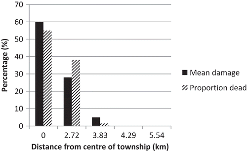
Both the number of dead trees and the extent of damage to living trees (<3 m tall) decreased along the gradient from the township westwards (). Although there were only a few small trees (<3 m) at Oatlands Park and at Croft Street, there was no damage. Overall, there was a robust positive relationship (r2 = 0.71; p = 0.07) between the probability of livestock and the damage level, but significance was compromised by the small sample size.
Figure 1. The mean extent of damage (% of tree volume removed) and number of dead trees (<3 m tall) in public green spaces of increasing distance from the centre of the township.
Each factor in the planting experiment was assessed individually because of the unbalanced design (with caged trees on cattle farms but not public green spaces) and the small sample size, further exacerbated by missing trees. This precluded examining interactive effects. Nonetheless, strong differences were evident for some of the factors (). The starkest contrast was between thorny species and non-thorny species, with a six times greater damage on non-thorny species. Significant differences were also evident between non-caged and caged trees, with damage being almost three times greater on the former than the latter, and between trees in public urban green spaces and those on cattle farms. The last comparison shows that the combined effects of people and livestock in urban green space were 40% greater (relatively) than on farms where there were only cattle as a potential damaging agent. Four trees were missing, all from the urban green spaces. Whilst they might have been uprooted and removed by cattle, the nature of the disturbance led us to conclude that they had been deliberately removed, i.e. stolen. The chilli-spray treatment was only applied once, and yet there was a 12% difference in damage levels between unsprayed trees and sprayed ones 6 months later. It suggests that had the treatment been continued, significant results might have been noted. There was no significant difference in damage levels between palatable and non-palatable species.
Table 3. The mean (± SD) percentage damage to trees 6 months after being planted in urban greens spaces and cattle farms.
4.4. Residents’ and broader perceptions
Over 85% of respondents at Sani Memorial, Lavender Valley and Oatlands said that they regularly see livestock, mostly cattle, in the park near where they live. Approximately, three-quarters of the residents were of the opinion that livestock have negative impacts on the quality of the park neighbouring where they live (75% at both Lavender Valley and Oatlands and 70 % at Sani Park). Only 20% of the respondents at Lavender Valley and 15% of the respondents at Sani Memorial Park and Oatlands Park felt that the parks were maintained adequately by the municipality. Therefore, the overwhelming majority of respondents at all the parks felt that the municipality had failed in its duty to maintain these parks.
Most respondents (55–60%) living near the three surveyed parks felt that the livestock and their owners were primarily to blame for the damaged trees and poor conditions of the park, with vandalism by youths also being a contributing factor. However, between 15% (Sani Memorial) and 30% (Lavender Valley) of respondents stated that the main cause of damage to the park trees was vandalism. Not unsurprisingly therefore, the majority of the respondents at all three parks felt that livestock should not be allowed to graze in the parks. However, 35% of the respondents at Oatlands felt that livestock should be allowed to graze compared to the lower percentage of 25% and 20% of the respondents at Sani Memorial Park and Lavender Valley, respectively. With only 15% of the sample households owning livestock, this shows that some non-owners were sympathetic to having livestock grazing in public green spaces. Two of the nine owners replied that they felt that livestock should not graze in the designated public parks, but should be allowed to graze road verges and informal green spaces within the city.
Three-quarters of the 26 IERM respondents stated that there were urban livestock in the municipality in which they worked, and 60% of these said that livestock had a negative impact on green spaces and/or trees. Two-thirds also stated that they regularly received complaints from residents about livestock in the urban spaces. Just over half reported that the damage caused by livestock was a disincentive to them to plant trees or maintain parks in certain parts of their town, i.e. where livestock were most prevalent.
5. Discussion
Shackleton (Citation2012) emphasised several differences between urban forestry and greening in developing countries compared to developed ones, a significant one being the presence of livestock in many towns and cities in the developing world. He argued that the presence of urban livestock would necessitate different approaches and tree species to minimise damage whilst optimising the provision of fodder and forage to the livestock. This was supported by the results of Richardson and Shackleton (Citation2014) who showed high levels of damage to newly planted street trees across several towns in South Africa, which approximately half of local residents attributed to livestock. This is likely to be driven, to some extent, by the small area of greenery in urban settings, which is frequently reconfigured and reduced through rezoning and infrastructure development. Such rezonings can jeopardise the livelihoods of those urban residents for whom livestock are an important livelihood option (Alam & Ahmad Citation2010; Mundoli et al. Citation2015). Hence, this current study to assess the compatibility of livestock and green spaces in urban settings of South Africa. In that regard, we have several unequivocal findings.
First, it is clear that any livestock pressure is spatially variable. The gradient approach showed that urban green spaces closest to the township, which is where most urban livestock owners reside (Davenport & Gambiza Citation2009), experienced significantly higher livestock densities and probabilities than green spaces further away. This was reflected in higher soil compaction and damage levels on trees and the reduced plant litter. Low litter and high compaction typically result in reduced water infiltration, higher run-off and lower nutrient cycling.
Second, the planting experiment revealed a large difference in the levels of damage between trees in public urban green spaces (54%) and neighbouring cattle farms (38%). This suggests that whilst cattle do exert significant damage to newly planted trees, almost as much damage is likely to be attributable to human agency in the public green spaces, either via theft or wanton damage to the trees. This more or less corroborates the local residents’ perceptions reported by Richardson and Shackleton (Citation2014). The results in this current survey revealed a slightly higher, but similar magnitude (50–60%) of respondents identifying livestock as the primary cause of damage to the urban trees. Although based on a small sample, the wider national survey confirmed that the concern of livestock damaging urban trees is not unique to our study town, with 60% saying that they were a problem, and just over of half saying that the levels of damage were sufficient to discourage them from planting more trees in the worst affected areas of the towns in which they operate. This further supports and provides evidence to the contention that livestock are major forces in shaping the nature and appearance of urban green spaces (Dingaan & Du Preez Citation2013).
This study has revealed a high conflict of interest in demand for different ecosystem services from urban green spaces and trees in Grahamstown. The municipality is seeking to provide attractive and accessible green areas for recreation and aesthetics, whilst livestock owners require green spaces for grazing, fodder and shade for their animals. The majority of residents opined that the presence of livestock resulted in a deterioration of the quality of the park near their homes, as did some of the livestock owners. Whether or not these competing needs can be accommodated within the same green spaces needs further analysis and innovative solutions. If not, then there may be need for spatial separation between the different uses.
If the different bundles of benefits are to be delivered in the same space, then the municipality will have to consider different strategies for planting trees. One would be to reconsider the species of trees planted. Our results show that levels of damage to thorny species were significantly lower than on other species, mirroring results from more natural environments (e.g. Cash & Fulbright Citation2005). Currently, the municipality does not stock nor plant any thorny species, but it is likely that they could be used in places where they do not pose any danger to park users. Or they could be used to shield non-thorny species until they are established and then the thorny barrier plants removed. Secondly, planting larger trees can reduce damage and vandalism levels (Pauleit et al. Citation2002; Richardson & Shackleton Citation2014). The added costs of keeping trees in the nursery for longer and the higher transport and preparation costs for large trees might mean fewer trees can be planted. But if the levels of damage are significantly less, it is likely to be a beneficial trade-off in the long run. Another option is to plant trees within protective structures. However, these must be of a suitable design to ensure livestock cannot still access the trees, and must also be accepted by the local community otherwise they may be vandalised or the materials removed for uses in private homesteads (Richardson & Shackleton Citation2014). Lastly, it might be possible to work with livestock owners to ensure that there is always a herder with their animals who can deter the animals from browsing on newly planted trees in specific areas until the trees are sufficiently tall. There is a livestock owners association but it is not very functional and tends to focus more on the municipal commonage around the town (Davenport & Gambiza Citation2009) rather than green spaces within the town. It is conceivable that greater engagement by the municipality with the association’s aims and needs might lay the foundation for more functional management of livestock on the commonage and within the town. Given the cultural importance of livestock to Xhosa people (Ainslie Citation2013), it is unlikely that any outright ban on livestock in the green spaces would be viable, as disregard of the current by-laws by many livestock owners indicates. If spatial separation were the only strategy, then some green spaces would have to be firmly fenced or walled to keep livestock out. Such a strategy might simultaneously provide a safer environment for small children. For example, Dennis and James (Citation2016) reported how volunteerism and visits to local parks were positively related to a sense of security, which in Greater Manchester, UK, was associated with secure fencing. However, there is also an opposing view that generally, walled areas reduce a sense of place and ownership by communities, as well as reduce physical accessibility for some (Okvat & Zautra Citation2011). If, on the other hand, livestock are unherded, it might perhaps be possible to mobilise a citizen network of local residents who wish to use the parks for other purposes to drive the livestock away from the formal green spaces and thus prompting them to use the informal green spaces and road verges. The social and ecological consequences of such would require consideration, but since livestock already use these informal spaces, the implications would probably be manageable. A core consideration would be the increased grazing pressure because of the reduced area available for grazing.
In considering these potential strategies, it is necessary to note that Grahamstown has a large commonage area of several thousand hectares on the periphery of the city, as do many other small and medium-sized towns in the region (Davenport et al. Citation2012). The primary use of these lands is grazing (Davenport & Gambiza Citation2009). However, many livestock owners fear that their livestock will be stolen and hence house their animals in the city overnight and let them forage within the city boundaries during the day (Richardson & Shackleton Citation2014). Owners of large herds can afford to hire herders and tend to dominate the commonage (Davenport & Gambiza Citation2009). There is evidence that the herbaceous composition of the commonage has been altered by the heavy grazing (Puttick et al. Citation2014). Thus, if there is a need for spatial separation between livestock and other green space users, it would be important that they include strategies and mechanisms for optimisation of the use of the municipal commonage as well as safety of animals grazed there. There is anecdotal evidence that cattle densities increase in the town during winter when forage on the commonage is most limited and of poor quality. Thus, it is possible that the stocking densities observed in this study during late summer would be higher in the winter months (June–September).
Whilst the focus of this research has been on damage caused by livestock, it should not divert attention away from the damage caused to trees by some residents. The results indicate that a considerable proportion of the damage to trees is likely to be a result of wanton human vandalism. Additionally, four trees were lost, which we believe was direct theft. Gwedla (Citation2016) mentioned theft of newly planted trees as a source of annoyance to urban residents in Eastern Cape towns. On the one hand, it is positive that some local residents are interested in planting trees in their own properties, but on the other, it is disturbing that they are prepared to do so at the expense of the amenities provided to the community as a whole. Thus, strategies and solutions for urban greening in towns of the region, and similar ones where livestock are common need to involve all communities and not just the livestock owners.
At a larger scale, this paper has shown the need for greater consideration of the diversity of needs of local residents in terms of their uses of urban green spaces. Such diversity of needs and uses may be greater in the Global South. And planning for such diversity requires creating environments and fora in which local people can expresses their needs and concerns, and discuss solutions to competing needs. It also requires that planners and authorities engage and participate in such fora. In South Africa, urban development projects and strategies to promote urban sustainability rest in the Integrated Development Planning approach, which shares many features in common with Local Agenda21 (Ruwanza & Shackleton Citation2016). However, there is a gap or barriers between the participation and consultation processes and the final plans that are developed and implemented. Thus, social spaces are created to allow for the poorer sectors of towns and cities to voice their needs and address past and current inequities, but sustainability is compromised as these are not translated into the spatial plans and programmes on the ground (Pasquini et al. Citation2015). This requires an understanding of such barriers and the development of simple and cost-effective tools to develop solutions and equitable trade-offs between competing demands on urban natural resources and green infrastructure.
Acknowledgements
We are grateful to the survey respondents for their time and knowledge, and Lawrence Sisitka and Geoff Antrobus for allowing us to use their farms as controls. This work was funded by the South African Research Chairs Initiative of the Department of Science and Technology and the National Research Foundation of South Africa. Any opinion, finding, conclusion or recommendation expressed in this material is that of the authors and the NRF does not accept any liability in this regard.
Disclosure statement
No potential conflict of interest was reported by the authors.
Additional information
Funding
Related Research Data
References
- Ainslie A. 2013. The sociocultural contexts and meanings associated with livestock keeping in rural South Africa. Afr J Range For Sci. 30:35–38.
- Alam MJ, Ahmad MM. 2010. Analysing the lacunae in planning and implementation: spatial development of Dhaka city and its impacts upon the built environment. Intn J Urb Sust Dev. 2:85–106.
- Albert C, van Haaren C. 2014. Implications of applying the green infrastructure concept in landscape planning for ecosystem services in peri-urban areas: an expert survey and case study. Planning Prac Res. doi: 10.1080/02697459.2014.973683.
- Amadou H, Dossa LH, Lompo DJ, Abdulkadir A, Schlech E. 2012. A comparison between urban livestock production strategies in Burkina Faso, Mali and Nigeria in West Africa. Trop Anim Heal Prod. 44:1631–1642.
- Banegas N, Albanesi AS, Pedraza RO, Dos Santos DA. 2015. Non-linear dynamics of litter decomposition under different grazing management regimes. Plant Soil. 393:47–56.
- Blackmore M, Vitousek PM. 2000. Cattle grazing, forest loss, and fuel loading in a dry forest ecosystem at Pu’u Wa’aWa’a Ranch, Hawaii. Biotrop. 32:625–632.
- Busck AG, Kristensen SP, Præstholm S, Primdahl J. 2008. Porous landscapes – the case of greater Copenhagen. Urb For Urb Green. 7:145–156.
- Cash VW, Fulbright TE. 2005. Nutrient enrichment, tannins and thorns: effects of browsing in shrub seedlings. J Wildl Mgmt. 69:782–793.
- Chaturvedi A, Kamble R, Patil NG, Chaturvedi A. 2013. City–forest relationship in Nagpur: one of the greenest cities of India. Urb For Urb Green. 12:79–87.
- Climatedata. 2013. World climate data. Available from: www.climatedata.eu
- Chuong J, Huxley J, Spotswood EN, Nichols L, Mariotte P, Suding KN. 2016. Cattle as dispersal vectors of invasive and introduced plants in a California annual grassland. Rangel Ecol. Mgmt. 69:52–58.
- Davenport NA, Gambiza J. 2009. Municipal commonage policy and livestock owners: findings from the Eastern Cape, South Africa. Land Use Pol. 26:513–520.
- Davenport NA, Shackleton CM, Gambiza J. 2012. The direct use value of municipal commonage goods and services to urban households in the Eastern Cape, South Africa. Land Use Pol. 29:548–557.
- Dennis M, James P. 2016. User participation in urban green commons: exploring the links between access, voluntarism, biodiversity and well-being. Urb For Urb Green. 15:22–31.
- Dingaan MNV, Du Preez PJ. 2013. Grassland communities of urban open spaces in Bloemfontein, Free State, South Africa. Koedoe. 55:1–8.
- Fabricius C, Koch E, Magome H, Turner S. 2004. Rights, resources and rural development. London: Earthscan.
- Fetene A, Worku H. 2013. Planning for the conservation and sustainable use of urban forests in Addis Ababa, Ethiopia. Urb For Urb Green. 12:367–379.
- Gwedla N. 2016. Patterns of street tree abundance, composition and residents’ acceptance across ten small and medium-sized towns in the Eastern Cape, South Africa [ MSc thesis]. Grahamstown: Rhodes University. 132 p.
- Halloran A, Magid J. 2013. Planning the unplanned: incorporating agriculture as an urban land use into the Dar es Salaam master plan and Beyond. Environ Urban. 25:541–558.
- Hansen R, Pauleit S. 2014. From multifunctionality to multiple ecosystem services? A conceptual framework for multifunctionality in green infrastructure planning for urban areas. Ambio. 43:516–529.
- Krzic M, Newman RF, Trethewey C, Bulmer CE, Chapman BK. 2006. Cattle grazing effects on plant species composition and soil compaction on rehabilitated forest landings in central interior British Columbia. J Soil Water Cons. 61:137–144.
- Kuruneri-Chitepo C, Shackleton C. 2011. The distribution abundance and composition of street trees of selected towns of the Eastern Cape, South Africa. Urb For Urb Green. 10:247–254.
- Lee-Smith D. 2010. Cities feeding people: an update on urban agriculture in equatorial Africa. Enviro Urban. 22:483–499.
- Liu G, Lucas M, Shen L. 2008. Rural household energy consumption and its impacts on eco-environment in Tibet: taking Taktse county as an example. Renew Sust Energy Rev. 12:1890–1908.
- Makana Municipality. 2013. IDP and municipal statistics: employment status [ Online]. [cited 2015 Apr 12]. Available from: http://www.makana.gov.za/wpcontent/uploads/2013/07/Employment-status.pdf
- McConnachie MM, Shackleton CM, McGregor GK. 2008. The extent of public green space and alien plant species in 10 small towns of the sub-tropical thicket biome, South Africa. Urb For Urb Green. 7:1–13.
- Mucina L, Rutherford CR, editors. 2006. The vegetation of South Africa, Lesotho and Swaziland. Strelitzia 19. Pretoria: South African national Biodiversity Institute.
- Mundoli S, Manjunath B, Nagendra H. 2015. Effects of urbanisation on the use of lakes as commons in the peri-urban interface of Bengaluru, India. Intn J Urb Sust Dev. 7:89–108.
- Okvat H, Zautra A. 2011. Community gardening: a parsimonious path to individual, community, and environmental resilience. Comm Psych. 47:374–387.
- Pasquini L, Ziervogel G, Cowling RM, Shearing C. 2015. What enables local governments to mainstream climate change adaptation? Lessons learned from two municipal case studies in the Western Cape, South Africa. Clim Dev. 7:60–70.
- Pauleit S, Jones N, Garcia-Martin G, Garcia-Valdecantos JL, Riviere LM, Vidal-Beaudet L, Bodson M, Randrup TB. 2002. Tree establishment practice in towns and cities –results from a European survey. Urb For Urb Green. 1:83–96.
- Puttick JR, Hoffman MT, Gambiza J. 2014. The impact of land use on woody plant cover and species composition on the Grahamstown municipal commonage: implications for South Africa’s land reform programme. Afr J Range For Sci. 31:123–133.
- Reiner R, Craig A. 2011. Conservation easements in California Blue Oak Woodlands: testing the assumption of livestock grazing as a compatible use. Nat Areas J. 31:408–413.
- Richardson E, Shackleton CM. 2014. The extent and perceptions of vandalism as a cause of street tree damage in small towns in the Eastern Cape, South Africa. Urb For Urb Green. 13:425–432.
- Roy S, Byrne J, Pickering C. 2012. A systematic quantitative review of urban tree benefits, costs, and assessment methods across cities in different climatic zones. Urb For Urb Green. 11:351–363.
- Ruwanza S, Shackleton CM. 2016. Incorporation of environmental issues in South Africa’s municipal integrated development plans. Intn Journal Sust Dev World Ecol. 23:28–39.
- Sandström UF. 2002. Green infrastructure planning in urban Sweden. Plann Pract Res. 17:373–385.
- Shackleton CM. 2012. Is there no urban forestry or greening in the developing world? Sci Res Ess. 7:3329–3335.
- Wassie A, Sterck FJ, Teketay D, Bongers F. 2009. Effects of livestock exclusion on tree regeneration in the degraded highlands of northern Ethiopia. For Ecol Mgmt. 257:765–772.
- Wright H. 2011. Understanding green infrastructure: the development of a contested concept in England. Local Environ. 16:1003–1019.
- Yoshitake S, Soutome H, Koizumi H. 2014. Deposition and decomposition of cattle dung and its impact on soil properties and plant growth in a cool-temperate pasture. Ecol Res. 29:673–684.
- Young RF. 2010. Managing municipal green space for ecosystem services. Urb For Urban Green. 9:313–321.