
ABSTRACT
Co-production in climate change has arisen in response to improving climate knowledge. Climate service co-production provides climate knowledge for decision-making, benefiting vulnerable communities with useful and usable information such as flooding risk areas. A climate service co-production project, including mapping technologies, has been conducted in Jakarta, Indonesia. However, it has not been integrated into mainstream spatial planning. This paper investigates an enabling environment for the integration of climate service co-production and spatial planning using a collaborative governance framework. We conducted semi-structured interviews, photovoice, and focus group discussions. The results highlight factors to enable integration; (1) an institutional reform to put climate service co-production on the agenda, (2) top-down priorities aligned with local-level needs, (3) local government will and leadership to execute the tasks and actions towards climate resilience, (4) trust of the local government with the community, (5) integrated geospatial data to have an effective climate knowledge to spatial planning.
1. Introduction
There are multiple ways of building spatial knowledge. Knowledge can be scientific (codified), context embedded based on professional experience, context embedded and socially constructed (community knowledge), as well as tacit (Pfeffer et al. Citation2015). A conflict in knowledge production occurs where one actor relies exclusively on scientific and professional knowledge while the other actor has knowledge from daily living experiences, such as context embedded community knowledge (Zolkafli et al. Citation2017). Professional planners are sceptical about communities’ capacity to be involved in planning (Zolkafli et al. Citation2017). This lack of recognition of community knowledge can result in disjointed actions and jeopardise effective planning and decision-making processes. Therefore, this paper investigates an enabling environment for the recognition and integration of community knowledge on climate services into spatial planning. We analyse the capacity for joint action using a collaborative governance framework in Jakarta, Indonesia.
In the 1970s, Ostrom coined the term ‘co-production’ to explain the potential relationships between scientists and communities. Ostrom (Citation1996, p. 1073) defined co-production as the process ‘through which inputs used to produce a good or service are contributed by individuals who are not “in” the same organisation’. Her work has been relevant in the theory and practice of knowledge and governance for global sustainability (Miller and Wyborn Citation2018). The conflict in knowledge production between government, scientists, and the community can be bridged and lead to creating a reciprocal relationship of knowledge and actions through what is called co-production (Lemos and Morehouse Citation2006; Bovaird and Loeffler Citation2012; Vincent et al. Citation2018).
Communities are at the core of the co-production concept. Co-production emphasises that the production and delivery of services would not be successful without active participation from the community (Ostrom Citation1996). This co-production role not only enhances the quality of public services but also allows communities to be the main actor in decision-making (Ostrom Citation1996). What is needed is possible combinations of input from a government and from the community, in which their inputs are complementary and thus, the best possible outcomes can be achieved for both sources (Ostrom Citation1996).
In climate literature, the concept of co-production in climate change has arisen in response to improving climate knowledge between the government, scientists, and the community, albeit it is still unpopular in developing countries because of unawareness of the long history from co-production in other fields such as participatory development (Vincent et al. Citation2018). Climate service co-production is an effort to provide climate knowledge for decision-making while directly benefiting a vulnerable community with useful and usable information (Vincent et al. Citation2018). Climate services provide climate information for decision-making that involves not only high-quality data (e.g. on temperature, rainfall, wind) but also vulnerability analyses, assessment and long-term projections and scenarios (GFCS Citation2009). Such services require active collaboration among different stakeholders that must respond to users’ needs (GFCS Citation2009) so that it will create a resilient community. Community resilience is determined by the ability of affected people to withstand and absorb disturbance, and self-organise to adapt and return to the functioning of their system as it was and may be through co-production climate knowledge (Solar Citation2014).
Currently, decision-makers are overwhelmed by the urgency of reducing climate change impacts; however, most do not have any background with climate science (Briley et al. Citation2015). When climate knowledge needs to be integrated into planning development, decision-makers face three main challenges; (1) they find it difficult to attain climate knowledge (Olhoff Citation2011; Taylor Citation2013; Briley et al. Citation2015), (2) they assume a stable climate in their planning frameworks, thus constraining any attempt to incorporate climate knowledge into planning (Measham et al. Citation2011), (3) they often perceive that climate knowledge from the community is not usable in decision-making (Lemos and Rood Citation2010).
Integrating climate knowledge co-production into spatial planning development is essential and more sustainable than designing and managing climate policies separately from ongoing activities (Reid and Huq Citation2014). In this way, integration is also a means of successful co-production to leverage participation for decision-making processes. In Jakarta, Indonesia, there is an established need to integrate climate service co-production into spatial planning (Wijaya Citation2015).
Jakarta is the city with the highest vulnerability to climate change impacts amongst Southeast Asian cities (Yusuf and Francisco Citation2009). Jakarta is a low-lying coastal city with 3.7% of Indonesia’s total population (London Citation2018). About 40% of Jakarta’s total area is below sea level, in a deltaic plain of 13 natural rivers and 1,400 km of human-made waterways (Sunarharum Citation2016).
To co-produce climate knowledge towards building community resilience in Jakarta, several Non-Governmental Organisations (NGOs) initiated a project called Participatory Urban Neighbourhood Assessment (PUNA) in the most vulnerable coastal village, named Marunda, home to 29,465 inhabitants (Statistics Indonesia of Jakarta Utara City Citation2017). Marunda is a densely populated urban village in a location that is highly prone to climatic hazards. The community suffers from socio-economic inequalities and many other problems, such as poverty, lack of access to basic services, frequent flooding from rivers and rising sea-level, and high winds.
This paper aims to investigate an enabling environment for the integration of climate service co-production and spatial planning processes in Jakarta. Firstly, we discuss collaborative governance in climate change. We continue describing the integration barriers of climate service co-production into spatial planning and present PUNA as an example of a climate service co-production. Thereafter, we describe the conceptual framework of this research. Subsequently, we present an empirical study of the outcomes of climate service co-production, barriers to integration initiatives in Jakarta, as identified by the local government and the community, and then discuss the findings. Lastly, we present what constitutes as an enabling environment for the integration of climate service co-production and spatial planning in Jakarta. Thus, this paper contributes to a better understanding of knowledge co-production and in particular, developing a strategy to promote climate service co-production, as well as addressing climate change impacts on development.
2. Collaborative governance in climate change
Collaborative governance promises better coordination and integration among stakeholders. Governance is a relationship between the governed (citizens/civil society/their institutions) and the governing (the government and its institutions and private sector interests) (McCall and Dunn Citation2012). Governance refers to a process that helps to manage the relationship between the government and society in a bottom-up way (Gupta et al. Citation2015). Within the context of collective action, governance can be defined as an action to govern collaboration in the public and/or private sector (Emerson et al. Citation2012). As such, collaborative governance is the process of decision-making that involves people across all elements of stakeholders to constructively carry out a common purpose (Ansell and Gash Citation2008; Emerson et al. Citation2012). A common purpose of collaborative governance would be to reduce climate change impacts.
Climate change is one of the most complex and pressing challenges faced at a global scale. The importance of climate change adaptation and mitigation is demanding governmental, private sectors and the community to take actions together (Emerson and Gerlak Citation2014). Thus, collaborative governance in climate change is needed to create leadership, knowledge and information, as well as resources towards climate change adaptation and mitigation (Emerson and Gerlak Citation2014). It uses three key techniques, including collaborative learning, networking, and the promotion of multi-stakeholder partnerships (Kallis et al. Citation2009; Brunner Citation2010; Aytur et al. Citation2015). As collaborative learning was illustrated by Brunner (Citation2010), it studies common interests between stakeholders to find a ‘win-win’ policy. Thereafter, it continuously encourages collaborative learning with networking or shared knowledge (Kallis et al. Citation2009; Brunner Citation2010). Sharing an understanding of climate change enables appreciation and flexibility for forecasting, modelling, and experimentation (Emerson and Gerlak Citation2014). The third key element is the creation of boundary organisations or multi-stakeholder partnerships (Kallis et al. Citation2009). Kallis et al. (Citation2009) defined these partnerships as the institutionalised forums of various stakeholders and the knowledge to work together to have one goal.
Two approaches arise in climate practices, though some involve more of the community (e.g. community/public participation), while the other work is conducted through scientists networks. A method that has been used in community-based organisations is known as Participatory Spatial Planning (McCall and Dunn Citation2012), or Participatory GIS (PGIS) (Sieber Citation2006). This approach focuses on spatial planning and management in a more generic model with four basic phases, including exploration, assessment, design of alternative, and action (McCall and Dunn Citation2012). It applies Geographic Information Systems (GIS)tools, and other geo-information outputs (e.g. sketch maps, topography maps, satellite images) for collecting and communicating climate information (McCall and Dunn Citation2012). With the use of maps, this approach gives a space for engaged stakeholders, vulnerable communities, to collaboratively map, design, analyse, validate, and share their local knowledge about climate hazard impacts (McCall and Dunn Citation2012). For example, Kienberger and Steinbruch (Citation2005) describe the PGIS method in the case study of Búzi, Mozambique. PGIS methods were applied to assess the community’s vulnerability to hazards such as cyclones, floods, and drought. An example of climate practices through scientists networks is applied by the Great Lakes Integrated Sciences and Assessments Program (GLISA) (Lemos et al. Citation2014). GLISA is a boundary organisation that specialises in producing and providing climate information (Briley et al. Citation2015). As they acknowledge that the partnership between science and society is imperative, they have created a collaborative approach called the boundary chain approach, which aims to bridge all stakeholders by using climate information (Lemos et al. Citation2014).
3. Barriers in integrating climate service co-production into spatial planning
Since 1992 through the United Nations Framework Convention on Climate Change (UNFCCC), there has been a significant amount of attention to conduct collaboration initiatives in combating climate change impacts among practitioners and policymakers over the globe; however, this has not been achieved efficiently. This is especially true, regarding the integration of community-based activities and outputs with spatial planning. Case studies show similar barriers and challenges considered to be wicked problems, such as institutional arrangements, knowledge, leadership, and resources (Measham et al. Citation2011; Emerson et al. Citation2012). This section presents empirical studies of the integration process of climate service co-production into spatial planning.
One example of institutional arrangement barriers is from Measham et al. (Citation2011) that investigated the barriers and challenges in the integration of climate service co-production in Sydney, Australia. The authors examined three barriers, including lack of information, lack of resources, and institutional limitations. They argued that institutional limitations were much more difficult to address, as climate adaptation information has yet to be embedded in the planning process. This was further explained as spatial planning having retained a strong mitigation bias regarding climate change, although community-based adaptation was acknowledged as an important issue for planning.
In terms of knowledge barriers, there has been an effort to integrate climate knowledge into long-term strategic city development planning in the case of Cape Town. Taylor (Citation2013) identified relevant barriers, such as a lack of information on when and where climate change impacts were experienced. The barriers of resources were also found to hinder the integration process, as the local government in South Africa works under limited public investment that affects the strategies’ implementation.
Leadership barrier is found in the case of Malawi, as Olhoff (Citation2011) found limited coordination in climate change adaptation (CCA) activities. This was compounded by a lack of coherent national policies on adaptation. Additionally, there were limitations in financial resources and technical capacity at all levels of government, as well as a lack of capacity building on CCA in communities.
In Indonesia, Wijaya (Citation2015) found four barriers that enhance effectiveness and improvement in the context of decision-making and policies related to the integration of climate service co-production. These four barriers included institutional and managerial, knowledge and information, financial and economic, as well as social and behavioural.
In summary, giving the examples of the four barriers and challenges over the integration of climate service co-production into spatial planning provide insight that (1) institutional arrangement barrier will fall upon managerial, institutional and governance limitation and fragmentation; (2) knowledge barrier concerns on limited information for both the community and government; (3) leadership barrier is relevant with the lack of connection to the communities; and insufficient capacity building in the community; (4) resource barrier relates to financial and economic problems such as limited public investment.
4. PUNA’s approach: climate service co-production in Marunda, Jakarta
The Participatory Urban Neighbourhood Assessment (PUNA) is a climate service co-production practice that has been used in Jakarta but is not yet integrated into spatial planning. Grassroots organisations initiated it in the Marunda village, North Jakarta, under the Marunda Urban Resilience in Action (MURIA) project from Cordaid.Footnote1 The project aimed to develop and execute a multi-stakeholder approach model to facilitate collaboration, producing climate community knowledge as inputs for decision-making. This was approached by strengthening the community’s capacity by using maps to identify risks, social capacity, and the potential for development in response to disaster preparedness. PUNA used the Cordaid resilience framework that consists of 1) individual/community groups, 2) basic needs and services, 3) livelihoods 4) ecosystems, 5) community structures and systems, and 6) enabling a policy environment (Cordaid Citation2016) (). explains each layer of the framework.
Figure 1. Cordaid resilience framework. Source: Cordaid (Citation2016)
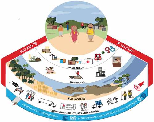
Table 1. Explanation of cordaid resilience framework layers. Source: Cordaid (Citation2016).
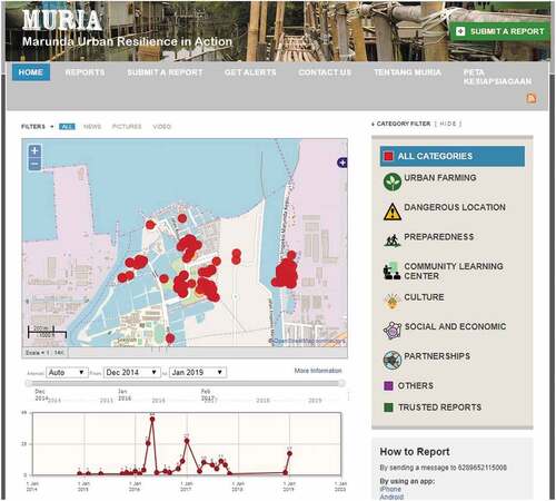
The tools used during the participation and analysis processes were village history, season calendar, flowchart, focus group discussions, in-depth interview, and transect mapping. To improve the results of participatory community initiatives, Cordaid cooperated with several local NGOs that involved youth groups in developing digital mapping using UshahidiFootnote2 and OpenStreetMapFootnote3 platforms. This was done so that the maps could be used and widely accessed to support transparency and inclusion. As one of the co-productions, this initiative identified flooding, which is caused by rain and an overflowing river that has been worsened by erosion. Thereafter, the results were disseminated through an online map ().
Figure 2. Web-based GIS of Marunda. Source: https://openstreetmap.id/muria/accessed 7 March 2019.
5. Collaborative governance framework
To investigate an enabling environment that integrates climate service co-production, such as PUNA, into spatial planning in Jakarta, this paper borrows part of the collaborative governance framework from Emerson et al. (Citation2012). The framework falls under Collaborative Governance Regimes (CGRs), which capture a wide range of collaboration activities (Emerson et al. Citation2012). This research adopts the capacity for joint action dimension that consists of institutional arrangements, leadership, knowledge, and resource variables. The four variables are recognised as key components that determine and sustain collaborative efforts in climate adaptation (Measham et al. Citation2011; Emerson and Gerlak Citation2014).
Procedural/Institutional arrangements refer to ‘the range of process protocols and organisational structures necessary to manage repeated interactions over time’ (Emerson et al. Citation2012, p. 15). In climate adaptation literature, institutional arrangements are seen as central determinants of the adaptive capacity (Adger et al. Citation2009; Measham et al. Citation2011). This variable captures the structures and functions of different stakeholders to set their roles together in climate actions (Emerson et al. Citation2012).
Leadership is essential, as it empowers all stakeholders to be involved in the decision-making process (Ansell and Gash Citation2008; Emerson et al. Citation2012). Leadership is considered to be a critical variable in taking responsibility, building trust, managing conflict, increasing communication, and maintaining relationships among different stakeholders (Measham et al. Citation2011; McCall and Dunn Citation2012; Emerson and Gerlak Citation2014). Likewise, leadership influences much of the process and output of climate adaptation planning.
Knowledge refers to ‘the social capital of shared knowledge that has been processed, weighed, and integrated with values and judgments of all participants’ (Emerson et al. Citation2012, p. 16). The complexity of climate change needs the integration of knowledge from different stakeholders (Lemos and Morehouse Citation2006). In this collaboration context, understanding of how climate knowledge fits users’ decision needs and connects to other kinds of knowledge from different stakeholders is essential to produce an effective integration of climate service co-production and urban planning (Emerson and Gerlak Citation2014).
Resources can be seen as budget support, time, technical skills, or organisational assistance to support bottom-up planning, as well as the process of collaboration (Emerson et al. Citation2012; Wijaya Citation2015). Successful collaboration is determined by the level of resources, including funding, legal, technical and expert assistance, information technology, and even power (Bryson et al. Citation2006). Working with multilevel stakeholders in collaborative partnerships requires resources that can be costly (Beierle Citation1998); hence, this variable measure to what extent an effective collaboration can be achieved (Emerson and Gerlak Citation2014).
The capacity for joint action dimension was chosen because it reflects some of the barriers that Indonesia (Wijaya Citation2015) and other nations (Measham et al. Citation2011; Olhoff Citation2011; Taylor Citation2013) encounter in integrating climate service co-production into spatial planning.
It should be noted that based on the ground and analysing of our data (explained in detail in the next section), we found two new variables that emerged that can further explain the capacity for joint action dimension: behaviour and technology. Interviewees’ responses had a clear reference to behaviour that also had an impact on the initial four variables. Furthermore, the technology variable was emphasised by respondents as one of the barriers that influence the integration of climate service co-production and Jakarta planning processes.
6. Methods
This paper used a qualitative approach, employing semi-structured interviews, focus group discussions, and photovoice techniques.
Semi-structured interview (SSI)
Semi-structured interviews were designed to examine the extent to climate service co-production that is needed to satisfy users as well as to investigate barriers to planning processes. Thus, the questions reflected the variables of the capacity for joint action dimension. Specifically, the questions for the knowledge variable have been formulated and posted to the community and local government. Variables of institutional arrangements, leadership, and resources have been targeted to the local government and hamlet chief, as these three variables are associated with government and governmental assistance (hamlet chief).
The participants were selected based on three criteria: (1) variance in gender, (2) familiarity with Marunda and its planning development issues and (3) community leader in the study area. In total, we interviewed 45 community members, including 22 men and 23 women, seven local government institutions that are relevant to spatial planning and disaster management, and the Chief of Marunda ().
(b) Focus group discussion (FGD)
Table 2. Matrix of participants, levels, methods and collaborative governance framework variables.
A focus group discussion was organised to get the overall perceptions of climate service co-production in Marunda from key informants in the community. It took approximately one to two hours to have an effective FGD, which consisted of 6–12 participants to produce reliable data (Langford et al. Citation2002). As such, we conducted FGD with six key informants for two hours.
(c) Photovoice
Photovoice (Nykiforuk et al. Citation2011) was applied during the interviews with the local government and FGD to bring a critical discussion to information on the online maps and probe users’ satisfaction with climate service co-production. We displayed online maps from the website (https://openstreetmap.id/muria).
All the methods were conducted and recorded between September and October 2017 in the Bahasa Indonesia language. The recordings were transcribed and translated into English for narrative and thematic analysis. We used Qualitative Data Analysis Software (QDAS) to analyse the interviews systematically. Furthermore, we did initial coding to define general themes from the transcripts. Then, we grouped the themes (axial coding) based on four variables of capacity for joint action dimension (institutional arrangement, leadership, knowledge, and resources). Thereafter, the identified themes were analysed using content analysis.
7. Results
7.1. Users’ perception of climate service co-production outputs in Marunda
In the FGD, key informants were satisfied with the representation of information on the online map. They recognised flooding by understanding the transparent blue colour above the base-map layer. The participants could also identify neighbourhood boundaries by recognising some specific places. Additionally, the representations of emergency shelters by icons also helped participants to understand these locations.
The key informants noticed that climate knowledge on the website should also separate the flooding extent based on the causes. As one of the participants in FGD commented, ‘This is mixed, not only because of the high tide, but flooding was caused by rainfall also. So, three neighbourhoods were affected by flooding with those two causes’. Besides, the participants encountered confusion in identifying evacuation routes. There were many overlapping lines and no signpost that could lead readers to understand the provided information. Thus, reactions included, ‘This is too small. Maybe we need to zoom in. We also feel confused, as things are overlapped!’ This indicates dissatisfaction of the representation of evacuation routes and the lack of distinction between different causes of flooding.
Regarding the local government perception towards the output of climate service co-production, the findings revealed that they are satisfied, as it is community-based information. However, the government suggested using the land-use plan map as a base layer to clearly define particular land-use where specific demands of the community are indicated (such as the emergency shelter locations). Indirectly, the government also needs the community to understand and be familiar with the official land-use plan.
It needs to be overlaid with a land-use plan so the community knows the land-use plan. For instance, let’s say that the community plots used as emergency shelters are currently empty land. When the plot has been implemented, but it turns out that there should be development there in the future, it means that those emergency shelters are not for the long-term.
The government is concerned about the coordination of information as well as the source of information. For instance, if the government finds that information about evacuation routes is acceptable, the government still needs to validate the information through direct observation, as evacuation routes should always be clear (without any hindrances). Furthermore, it will not be affected by any other development.
If these [points for emergency shelters] are decided to be evacuation shelters by the community, we should check whether those areas are ideal for evacuation shelters. If not, then we need to supply them with other facilities […] but, the most important thing is that the community knows better about those locations. At least, they know how to reach the locations and how safe the locations are. We [government] just control, monitor, and maintain if there is something unsuitable, and then we need to find other locations.
The government emphasises trust in the dissemination of information. They are concerned about the mechanism in obtaining data and who is responsible for approving the reports through dissemination.
We just want to avoid inaccurate information. Maybe the Chief can approve the data before it is disseminated. If we take information from the OpenStreetMap without knowing whether it is valid or not, that would be dangerous.
From these results, we conducted a thorough investigation of the barriers that influenced the integration process of climate service co-production and planning development in Jakarta. We analysed them through a collaborative governance framework.
7.2. Barriers influencing integration of climate service co-production into Jakarta spatial planning
Institutional Arrangements
The interviews revealed that there is an overlap of responsibility among relevant government institutions that hinder the incorporation of climate service co-production into the planning process. It is evident from respondents’ arguments that institutions encountered internal difficulties in the division of tasks and functions.
We realise that we are working in silos. We limit our work by our main tasks and functions, which are not divided clearly. We must work by issues. […] we can then divide our tasks, which fit our capacities as government institutions, not vice-versa.
This argumentation indicates that there is an unclear division of tasks and functions that is also compounded by a silo mentality in government institutions. It may also result in inadequate coordination and communication between the community and government entities to integrate the community’s initiatives through service co-production.
[…] if we talk about resilience, we talk about integration. It [integration] has not been developed yet. Thus, while there is a plan from BAPPEDA [Regional Development Planning Agency], there is another plan for mitigating disaster in Jakarta from BPBD [Regional Disaster Management Agency]. If the plan in BPBD is more for the preparedness-measures and responses, then it must be synchronised with spatial planning. The fact is that it lacks synchronisation with spatial planning. It would be better if spatial planning has it all.
It is clearly defined that the coordination between stakeholders in Jakarta has not been well established yet (Sunarharum Citation2016). Additionally, the policy framework, wherein the local government operates, is determined by the higher level of governance, including regional, provincial and national policies (World Bank Citation2011). As such, this leads to the lack of a local authority to make decisions for their local administration. An insufficient decision capacity at the local government will affect a conducive integration process for climate service co-production into spatial planning. This lack of local authority is argued by one of the respondents:
In Jakarta, we have a regional autonomy, in which all the final decisions are at the provincial level. Even the cities, such as North Jakarta, South Jakarta, East Jakarta, etc., they are administrative only, not for making policy or taking a final decision. That is all at the provincial level. We know our territory, we know the conditions, but our authority is ultimately stopped there.
Although the government at the city level can better acknowledge the demands of people within the city, however, the final decisions occur at a higher level. This constraint is doubled by the government lacking adequate coordination, including unclear responsibilities amongst all government institutions and obscuring their roles in climate actions. Consequently, the climate knowledge co-produced by the community is not integrated into formal planning processes since the community does not know whom they should approach and who coordinates.
(b) Leadership
All respondents acknowledged that Marunda has a high risk of coastal flooding. However, most of the government institutions are not helping people in response to climate hazards and risks. Respondents argued that in implementing area-based policies, specific issues should be prioritised. Nevertheless, the situation of Marunda does not make a significant impact on their priorities. As one of the government institutions stated:
We want to fulfil the community’s demands, but we have a set of priorities. It is impossible to give priority in Marunda. For example, due to congestion, the roads in Marunda must be widened. Whilst, Yos Sudarso Road [the primary road in North Jakarta] is not treated first. That is why the budget does not meet the demands of Marunda.
This quote indicates that there are competing priorities within relevant government institutions. Additionally, they set their priorities based on the functions and the benefits of higher scales. Instead, the local scale seems to be the last priority. As such, it shows a strong top-down development in Jakarta that hinders the integration of community initiatives into a higher level.
Furthermore, although there is a bottom-up approach named Musrenbang,Footnote4 which is annually organised by the local government, it has not been effective in accommodating the community needs. Our study observed that there had been no action or realisation of the community’s proposal so far. This finding strongly relates to the knowledge variable within the community and government. The results proved that the government tends to decide the development unilaterally. As the Chief of Marunda stated:
In the last Musrenbang in 2016, there were no service provisions for us. We had proposed many inputs/information related to environmental improvements, such as bridges and low-covered alleys, which should be raised. Unfortunately, there was nothing in 2016! […] Talk about process, there is a unilateral decision; there is a compromise. For example, about these vertical social housings, the local government is the one who decides. We just accepted their programs. It would be so much better if the government involves us [the community] to discuss their programs.
These quotes draw attention to the fact that there is still a gap in the policy-making process. The local government is expected to play an important role in relaying information from the community to a higher level, and vice versa (Archer et al. Citation2014). Furthermore, this can be seen in the current spatial planning in Jakarta, where there is still no adaptation planning embedded in planning (Sunarharum Citation2016). As one of the respondents explained:
I have studied RPJMD [Regional Medium-Term Development Plan] 2030 in Jakarta; there is not explicitly telling about disaster and resilience. There is open space, integrated kid-friendly public space, etc. Each governmental institution has a different perception of resilience […] whilst if we talk about resilience, we talk about integration. It [integration] has not been there yet […].
The finding shows that the Jakarta government has put less attention to climate adaptation, as it is not a priority for urban development. They decrease communication and the community’s trust by neglecting the community’s aspirations to urban development. Hence, it shows the Jakarta governments lack leadership in climate actions.
(c) Knowledge
Knowledge refers to social capital that is essential to produce climate information. Our findings reveal that the Jakarta government ignores what has been happening in Marunda. This is because the government acknowledged the phenomenon that happens in Marunda only from a general perspective. They are aware of the hazard risks, environmental conditions, and socio-economic factors in Marunda but do not understand the degree of its vulnerability.
Jakarta is about flooding and fire, for earthquakes and tsunamis have relatively low potential. Therefore, Jakarta has a high potential for flooding and fire.
Marunda is located in North Jakarta, which is one of the potential areas of coastal disaster because the area is lower than the sea. Also, there are many industries and warehouses.
These quotes reveal that government institutions acknowledge Marunda’s general conditions based on what exists on the shelf. However, they do not know the actual or specific problems in particular areas, such as the degree of community vulnerability and how they cope with natural hazards. The interviewees claimed that they had never received any information about specific Marunda conditions.
Such information [specific problems in Marunda] has never reached us. If there is such information, they should report it. […] In Musrenbang, they just complain, complain, complain, ‘this is broken, this is flooding, please fix the ditches’. But, the community does not give us detailed information.
Besides, the government of Jakarta lacks an understanding of how much knowledge the community has related to hazards, risks and climate change that can be incorporated to have a robust mitigation plan.
People do not know if a development needs a sacrifice. Their mindsets are not in line with what we expected.
The perception of the government is that the community lacks knowledge and understanding of urban development issues. Consequently, the community’s knowledge is not considered in the decision-making process. This is strongly related to the behavioural issues of government institutions that are revealed in section e.
(d) Resources
The interviews revealed that there is a budget allocated to participatory processes, but there are insufficient human resources to accommodate the needs of Jakarta’s population through participatory practice. At this point, the government implicitly expects a collaboration from other sectors. As one of the government institutions stated:
One of Jakarta’s weaknesses is that it has a huge number of people if we compare it with other cities in the world. Therefore, to accommodate the population growth for standard facilities’ provisions is difficult, as well as to involve the community. We need more people. That is why there is a lack of communication with the community.
The lack of human resources has been linked to a lack of institutional arrangements, which is the division of tasks and functions within government entities. Furthermore, it will yield less attention to the community, which inhibits the effective integration for climate service co-production.
(e) Behaviour
The interviews revealed that behaviour is also one of the barriers that may influence the integration of community knowledge within the planning process. Most of the respondents have the misconception that communities cannot produce knowledge that can be integrated into spatial planning. As one of the government institutions stated:
If we can compare [our community] to the Netherlands, Singapore, England etc., their communities are very concerned about their cities. Secondly, they are willing to give positive inputs. Thirdly, they have knowledge. This is different from our community, especially Marunda, ‘pity’. So, we have Musrenbang, which is organised annually. Ideally, in Musrenbang, the community has to give us important inputs; however, they just complain, like, ‘Sir, our streets are damaged’, ‘Sir, we need a hospital’, which is only physical [public services provisions]. So, future planning has nothing yet, as they have no knowledge of urban planning.
Moreover, the government perceives a lack of commitment from the community and a mismatch with their efforts to involve people in the decision-making process. As one of the government institutions argued:
Before planning, we always make FGDs, […] the problem is that we invite the homeowners, at least the husband or the wife, but the fact that in Jakarta, the one who comes is not the homeowner; instead, it’s a housemaid or a driver or a babysitter. So, the information does not reach the homeowners. Therefore, we tried to organise the FGDs on the weekend, so that there is no excuse anymore about busy things. But still, people do not want to come.
The quote shows that all levels of government feel disappointed by the community’s attitudes and unawareness of the importance of their participation in the process. Therefore, the government takes a unilateral decision with the power that they have as decision-makers. Conversely, the community accepts what has been made by the government without prior consensus. As one of the community members stated:
Yeah, we are just at the bottom level, we just follow the higher level [government].
As such, it is the result of a top-down regime that hinders people from raising their voices. Consequently, it hinders the community from empowering themselves in mainstreaming their initiatives into planning processes in Jakarta.
(f) Technology
In the climate service co-production, technology could operate as a mediator between the users and producers and facilitate fair access to co-produced knowledge. Despite some positive views on the co-produced knowledge (section 7.1), interviewees also considered some aspects of mapping technologies as barriers in the integration of climate service co-production into spatial planning. They referred to differences in cartographic projections:
The projection used in Jakarta is still local T32, whilst BPBD [Regional Disaster Management Agency] with their Google Earth system use UTM. Now, we are trying slowly to change our coordinate projection
This quote proves one example of a gap in technical issues amongst government institutions. Integrating spatial data is a significant problem that inhibits knowledge sharing and collaboration with all stakeholders in Jakarta.
Regarding fair access and based on the community’s perspective, a web-based GIS can only be used by those who know how to use maps and have access to the internet. Most of the key informants in FGD felt that although they understood how to access information on the map, other people in Marunda, particularly older adults and children, might encounter difficulties while accessing the online map. This shows that access to information through online maps in the Marunda community is relatively low, raising equity concerns.
The six barriers identified synthesise that the integration of community-based adaptation planning into spatial planning relies immensely on; (1) the development of an enabling environment for institutional reform to support local actions (Measham et al. Citation2011) as a solution to institutional arrangement and leadership barriers; (2) the community, NGOs, and private sector should intervene in both infrastructure and social development to enable climate change adaptation as a key to solve leadership, resources, and technology barriers (Emerson and Murchie Citation2010); (3) developing capacity in government and the community through multi-stakeholder processes, in which this creates greater local ownership as an answer to knowledge, resources, and behaviour barriers (Archer and Dodman Citation2015).
8. Discussion
8.1. The outcomes of climate service co-production in Marunda
The option of using GIS mapping technology determines the accessibility and dissemination of data (Sieber Citation2006). The OpenStreetMap and Ushahidi platforms that are used to publish information about Marunda require internet access to upload or view the information. Most of the Marunda community does not know how to access the internet. According to Sieber (Citation2006), many people are marginalised by the use of a web-based map, such as older adults. Our study observed a large portion of older adults and children in Marunda without access to the internet. This GIS technology excludes several people that are not capable of using it. This condition does not reflect intended collaboration aspects in the climate service co-production. Similarly, in the context of water services co-production, it is acknowledged that ‘co-production is far from collaborative but instead tense and riddled with power asymmetries’ (Ahlers et al. Citation2014, p. 2). However, in Marunda, there was an explicit effort to involve the youth in the co-production process. Involving the youth in mapping could increase a sense of better understanding of, and belonging to, the community (Pfeffer et al. Citation2011).
Provided that integration barriers are addressed, the participatory aspects of the GIS technology and the recognition of community knowledge as a valid form of knowledge have the potential to contribute to foster citizenship through more equitable access to climate knowledge and decision-making. In the context of water and sanitation Moretto et al. (Citation2018), p.439) show that the collaboration between water agencies and residents has the potential for a ‘renewed vision of citizenship, based on residents’ voice, participation and control in the decision-making process’.
Regarding the Jakarta government’s perceptions, they feel satisfied with Marunda’s climate co-production outputs because the Marunda community could produce and share information about the climate hazard occurrences of their area through web-based GIS. However, the government shows a lack of trust and credibility on the community’s outputs, as it reflects on the leadership aspect of collaborative governance. Moreover, they are hesitant to incorporate the outputs, which some of the participants indicated in the interviews, stating, ‘We’re not sure if we can use the information because we don’t even know how they got this data and who validated the information.’ This lack of trust from the government could hamper co-production efforts.
This study shows that the community’s capabilities in collecting data with GIS technology could re-politicise the decision-making process in Jakarta, but only if synergies are found between the government and the Marunda citizens. When government-citizens relationships are cooperative and collaborative, and both actively participate, synergies occur, and co-production has the ‘opportunity to democratise and re-politicise the policy field of these services’ (Moretto and Ranzato Citation2017, p. 9) In the case of Marunda, this calls for more trustful collaboration with government institutions in the co-production process to integrate community and expert knowledge.
8.2. Barriers and enabling environment to integrating spatial planning
The collaborative governance framework allowed us to analyse the capacity for joint action. The capacity, which is to integrate service co-production into existing spatial planning practices, is defined with four variables. In Jakarta, we identified barriers related to institutional arrangements, leadership, knowledge, and resource variables, as well as behavioural and technological barriers.
In terms of institutional arrangements, the study revealed two main limitations that can hamper integration initiatives in Jakarta. This includes limited coordination between local and higher levels of administration and the lack of distinct responsibilities amongst government institutions. These two limitations can negatively influence the government’s priorities and interests for climate co-production initiatives (Lemos and Rood Citation2010). Then, they beget negatively on the awareness of participation, as well as worsen people’s behaviour and leadership (Lemos and Rood Citation2010; Wijaya Citation2015). The top-down character of decision-making is still deeply embedded in the planning process in all cities in Indonesia, including Jakarta (Firman Citation2004). This is a challenge for communities that wish to mainstream their initiatives. Inter-institutional issues regarding authority and responsibility are known but hardly addressed within governmental institutions. The silo mentality leads to frustration with government institutions and the community as it hinders collaboration. These findings emphasise that local governments have to play an essential and leading role in mainstreaming the co-production of spatial information (Cloutier et al. Citation2014).
Institutional issues are strongly related to leadership amongst government institutions in Jakarta when it comes to climate service co-production. Coordination amongst different levels of government has been challenging, as no institution has taken the responsibility to give meaningful attention to community engagement in decision-making processes. This issue is acute regarding specific higher-level priorities towards planning processes. Interviews with different levels of government make it clear that there is an assumption that all areas in Jakarta have similar issues, such as flooding and disregard of local differences. This generalised and uncoordinated view is constraining any attempt to incorporate co-production into spatial planning, as different areas/arenas have various approaches to derive solutions (Measham et al. Citation2011).
Regarding the lack of knowledge, it is shown that the coastal flooding that frequently happens in Marunda is seen as a common flooding problem by the Jakarta government, which leads to less attention by the government for community initiatives. This is worsened by the lack of trust that the government has towards the community, whom they perceive to be unable to participate in decision-making processes meaningfully. Based on this study, it is clear that the Marunda community has substantial local knowledge that can be used as inputs for development planning and also for the validation of development interventions (Adger et al. Citation2009; Yuen et al. Citation2013). Community’s participation, in the role of consumer and producer of knowledge with participatory GIS technology, and the integration in mainstream planning could turn the community into knowledgeable agents to the decision-making process (van Vliet Citation2012) as it would facilitate and legitimate community knowledge. Whereas, lacking awareness about public participation within the community complicates the issue of collaboration among stakeholders. Although there is a bottom-up process (Musrenbang) in Jakarta to accommodate community initiatives for decision-making, it seems impractical if mutual trust and awareness are not embedded with the government and the community (Verplanke et al. Citation2016).
Another barrier to integration identified was the lack of human resources, as well as technology and behavioural barriers. Based on the lack of human resources, it is evident that the local government needs professional assistance or external support to identify the specific vulnerabilities of communities in different areas, also found by Measham et al. (Citation2011). The local government in Jakarta expressed the need for mapping expertise, especially considering human resources, which hindered their capability to use and apply geospatial information in planning. This relates to a technological barrier due to different governmental institutions using various map projections. Although this is an issue that can be solved relatively easily, it slows down the process of integration, worsening the issue of trust and the credibility of data. Thus, there is a need to expand the collaboration to relevant government institutions to take part in the process of obtaining and providing information (Lemos et al. Citation2014). The availability of geographic data that the Marunda community has produced could be a stepping-stone that enables the community to raise their initiatives to decision-making processes. Thus, it can help the government to have more accurate and grounded climate knowledge.
Furthermore, the behavioural barrier can be addressed by enforcing the participatory process to the government, as it promises effective communication upon climate knowledge (Cloutier et al. Citation2014). The local community through the PUNA process has produced data in a web-based GIS, which governments can use as input in decision-making processes. The following issues in the PUNA process can be overcome through inclusive, robust and trustful forms of collaboration; a) only youths can operate the technology, b) the government lacks technical expertise, and c) government trust and credibility of data. It is recommended that those issues can be identified as opportunities for the government, the community, NGOs and academicians to increase collaboration in producing and disseminating reliable and credible information on climate change (Pfeffer et al. Citation2011). As Wijaya et al. (Citation2017) stated, data availability, quality and accessibility remain challenging for integrating climate knowledge into planning development in all cities in Indonesia, including Jakarta. The availability of community-based data as well as collaboration with NGOs and academicians can significantly help the local government to minimise the issues at the local level and also to reinforce technical expertise in Jakarta (Dilling and Carmen Citation2011).
Based on the above discussions, we highlight several factors that are critical to enabling climate service co-production to be integrated into spatial planning. Firstly, it is extremely needed for institutional reform to put climate service co-production on the agenda. The local government can argue a basis for reform at a higher level to be given the authority to plan climate change responses in conjunction with the community. The ability of Marunda community in producing web-based GIS knowledge could re-politicise the decision-making process in a more bottom-up approach. Measham et al. (Citation2011) stated that if urban resilience is to be a concern at the local level, then the capacity of people and institutions in climate change and hazard risks and how to adapt to the needs to be strengthened by giving the authority to manage and plan within and across all administrative boundaries. Moreover, this view is in line with Firman (Citation2004) and Wijaya et al. (Citation2017). They argued that the government role in planning development needs to change at all levels in Indonesia, while the capacity of local government in spatial management needs to be reinforced. Therefore, this effort will provide opportunities for raising awareness of local capabilities in overcoming climatic uncertainty, as well as reshaping socio-technical institutional relations (Archer et al. Citation2014; Archer and Dodman Citation2015).
Secondly, top-down priorities should be aligned with local-level needs and novels ways of community knowledge, as top-down planning in Jakarta prevails over bottom-up planning. It is argued that a coherent top-down policy framework is essential in ensuring the integration of climate service co-production into planning to avoid mismatched priorities amongst different levels of government (Archer et al. Citation2014).
Thirdly, based on the limitation of leadership, an effective community’s climate service co-production can be developed and embedded in planning if the local government has the will and leadership to execute the tasks and actions towards climate resilience (Archer et al. Citation2014; Barton et al. Citation2015). Information on climate change hazards and impacts, as well as their costs, provide a robust initial catalyst for the local government to transform their development towards a more sustainable one. This transformation is assisted by the acknowledgement that the environment, the community, and local wisdom have value (Pasquini et al. Citation2015). It is essential to emphasise that the development of leadership can be addressed through a participatory process (Cloutier et al. Citation2014).
We encourage the local government to trust the community regarding their abilities to provide data/information and to incorporate their knowledge to achieve effective adaptation planning, despite challenges in power. Apart from the role of the community in planning processes, local governments also need to have the ability to understand the importance of adaptation issues related to urban planning and management and to make it as one of the development priorities of Jakarta (Wijaya et al. Citation2017).
The final critical factor, related to the technological barrier, is to encourage the government of Jakarta to accelerate and focus on integrated geospatial data, as this aspect is highly relevant concerning an effective climate adaptation in spatial planning (Mardiah et al. Citation2017). Through participatory GIS technology, it will create alternative flows of local knowledge to be informed to the multiple levels of government as well as the community, as it also allows the community to act as knowledgeable agent (van Vliet Citation2012) in everyday urban practice. Therefore, there is a need for the local government to cooperate with the Geospatial Information Agency (BIG) and the National and Regional Disaster Management Agency associated with integrated data and information (Mardiah et al. Citation2017). It should be clear that integrated geospatial data contributes not only to resolving technical issues but also to unifying those different sectoral interests that are currently treated as silos.
9. Conclusion
The empirical evidence from Jakarta indicates that institutional reform is extremely needed for putting climate service co-production on the agenda where top-down priorities may well be aligned with local-level needs. We recommend that the government of Jakarta change the way they consider the role of local government and community knowledge in decision-making processes to better execution of tasks and actions. This is not only for delivering and implementing policies that have been made at a higher level, but it also requires that local authorities manage and plan their administrative units accordingly towards climate resilience. What can be done? Firstly, to trust the community to co-produce their adaptation and mitigation plans; secondly, to push for reform at higher levels of government to enable changes in the planning process that hamper local adaptation initiatives; and thirdly, to insert climate adaptation into a broader range of governmental institutions and policy (Measham et al. Citation2011). Important to remember that awareness is immensely needed, where every area or administrative unit in the city has different problems that should be solved by taking the local context and community knowledge into account, especially for mitigating hazard risks and climate change adaptation.
Furthermore, the use and integration of participatory GIS technology will encourage the community to be more active in the decision-making process. It will reduce knowledge gaps between the government and the community. Therefore, (local) government leadership must be enabled to solve institutional problems, have the resources to solve technical issues and to sustain a bottom-up process. How can this be achieved? First, it is necessary to move from a conception of capacity building from more knowledgeable to less knowledgeable stakeholders (Archer and Dodman Citation2015); secondly, to improve coordination across stakeholders and be more inclusive by utilising a variety of techniques involving GIS technology to have better co-production outputs. Another recommendation for service co-production is to expand the collaboration between the community, grassroots organisations, and government institutions, mutual trust, understanding, legitimacy, and commitment should be highly promoted. Sharing trust between the government and communities is imperative to facilitate an effective co-production process.
Acknowledgement
We want to express our appreciation to Cordaid Netherlands for their facilitation of this study and their valuable and constructive suggestions during the development of this research. We would also like to express our gratitude to the Cordaid team in Indonesia for their valuable contributions and their facilitation of fieldwork in Marunda, Jakarta.
Disclosure statement
No potential conflict of interest was reported by the authors.
Additional information
Notes on contributors
Arya Lahasa Putra
Arya Lahasa Putra is an experienced Geo-Information Specialist with a demonstrated history of working in the architecture & planning industry. He is currently based in Jakarta, Indonesia. He holds a Master of Science (M.Sc.) focused on Geo-Information Science in Urban Planning and Management from Faculty of Geo-Information Science and Earth Observation (ITC) of the University of Twente.
Javier Martinez
Javier Martinez is Associate Professor in the Department of Urban and Regional Planning and Geo-Information Management within the Faculty of Geo-Information Science and Earth Observation (ITC), University of Twente, the Netherlands. He received his PhD from the Faculty of Geosciences, Utrecht University, for his thesis Monitoring intra-urban inequalities with GIS-based indicators: with a case study in Rosario, Argentina. His research, publications and training experience are focused on the application of GIS, mixed methods and indicators for policy-making, urban poverty, and quality-of-life and intra-urban inequalities.
Jeroen Verplanke
Jeroen Verplanke is Educational Manager at the Faculty of Geo-Information Science and Earth Observation (ITC) of the University of Twente in the Netherlands. Since graduating as a physical geographer from Utrecht University, he has been working on the intersection of Social Science and Physical Spatial Planning, where stakeholder interests and land-use conflicts are at play. His work-related interests are in PGIS (Participatory Mapping and GIS) and VGI (Volunteered Geographic Information) and the role this plays in the interaction between policy-makers, planners and citizens.
Notes
1. Cordaid is a nongovernmental organisation based in the Netherlands that initiated the MURIA Project and cooperated with local NGOs
4. Musrenbang is an annual forum conducted by stakeholders to draw up regional and national development (Idajati et al. Citation2016).
References
- Adger WN, Dessai S, Goulden M, Hulme M, Lorenzoni I, Nelson DR, Naess LO, Wolf J, Wreford A. 2009. Are there social limits to adaptation to climate change? Clim Change. 93(3–4):335–354. doi:10.1007/s10584-008-9520-z.
- Ahlers R, Cleaver F, Rusca M, Schwartz K. 2014. Informal space in the urban waterscape: disaggregation and co-production of water services. Water Altern. 7(1):1–14.
- Ansell C, Gash A. 2008. Collaborative governance in theory and practice. J Public Administration Res Theory. 18(4):543–571. doi:10.1093/jopart/mum032.
- Archer D, Almansi F, DiGregorio M, Roberts D, Sharma D, Syam D. 2014. Moving towards inclusive urban adaptation: approaches to integrating community-based adaptation to climate change at city and national scale. Clim Dev. 6(4):345–356. doi:10.1080/17565529.2014.918868.
- Archer D, Dodman D. 2015. Making capacity building critical: power and justice in building urban climate resilience in Indonesia and Thailand. Urban Clim. 14:68–78. doi:10.1016/j.uclim.2015.06.007.
- Aytur SA, Hecht JS, Kirshen P. 2015. Aligning climate change adaptation planning with adaptive governance: lessons from Exeter, NH. J Contemp Water Res Educ. 155(1):83–98. doi:10.1111/j.1936-704x.2015.03198.x.
- Barton JR, Krellenberg K, Harris JM. 2015. Collaborative governance and the challenges of participatory climate change adaptation planning in Santiago de Chile. Clim Dev. 7(2):175–184. doi:10.1080/17565529.2014.934773.
- Beierle TC. 1998. Public participation in environmental decisions: an evaluation framework usingsocial goals. Discussion paper 99–06. [online]. Washington DC, Resources for the Future. doi:10.22004/ag.econ.10497
- Bovaird T, Loeffler E 2012. From Engagement to Co-production : The Contribution of Users and Communities to Outcomes and Public Value. doi:10.1007/s11266-012-9309-6
- Briley L, Brown D, Kalafatis SE. 2015. Climate risk management overcoming barriers during the co-production of climate information for decision-making. Clim Risk Manage. 9:41–49. doi:10.1016/j.crm.2015.04.004.
- Brunner RD. 2010. Adaptive governance as a reform strategy. Policy Sci. 43(4):301–341. doi:10.1007/s11077-010-9117-z.
- Bryson JM, Crosby BC, Stone MM. 2006. The Design and Implementation of Cross-Sector Collaborations: Propositions from the Literature. Public Admin Rev. 66(s1):44–55.
- Cloutier G, Joerin F, Dubois C, Labarthe M, Legay C, Viens D. 2014. Planning adaptation based on local actors’ knowledge and participation: a climate governance experiment. Clim Policy:1–17. doi:10.1080/14693062.2014.937388.
- Cordaid. 2016. Facing disaster, building resilience. [accessed 2019 Sep 28]. https://www.cordaid.org/en/wp-content/uploads/sites/3/2016/05/Final-resilience-4-pager.pdf
- Dilling L, Carmen M. 2011. Creating usable science : opportunities and constraints for climate knowledge use and their implications for science policy. Global Environ Change. 21(2):680–689. doi:10.1016/j.gloenvcha.2010.11.006.
- Emerson K, Gerlak AK. 2014. Adaptation in collaborative governance regimes. Environ Manage. 54(4):768–781. doi:10.1007/s00267-014-0334-7.
- Emerson K, Murchie P. 2010 Jun. Collaborative Governance and Climate Change: Opportunities for Public Administration.” In The Future of Public Administration, Public Management, and Public Service Around the World: The Minnowbrook Perspective, edited by R. O'Leary, D. Van Slyke, and S. Kim, 141–153. Washington, DC: Georgetown University Press.
- Emerson K, Nabatchi T, Balogh S. 2012. An integrative framework for collaborative governance. J Public Administration Res Theory. 22(1):1–29. doi:10.1093/jopart/mur011.
- Firman T. 2004. Major issues in Indonesia’s urban land development. Land Use Policy. 21(4):347–355. doi:10.1016/j.landusepol.2003.04.002.
- GFCS. 2009. What are weather/climate services? [accessed 2019 Nov 24]. https://gfcs.wmo.int/what_are_climate_weather_services
- Gupta J, Pfeffer K, Ros-Tonen M, Verrest H, Gupta J. 2015. An Inclusive Development Perspective on the Geographies of Urban Governance. In: Gupta J, Pfeffer K, Verrest H et al., editors. Geographies of Urban Governance: Advanced Theories, Methods and Practices. Cham: Springer International Publishing; p. 217-228.
- Idajati H, Pamungkas A, Kukinul SV, Fadlillah U, Firmansyah F, Nursakti AP, Pradinie K. 2016. Increasing community knowledge of planning process and online musrenbang process in Rungkut district Surabaya. Proc Soc Behav Sci. 227(November2015):493–497. doi:10.1016/j.sbspro.2016.06.105.
- Kallis G, Kiparsky M, Norgaard R. 2009. Collaborative governance and adaptive management: lessons from California’s CALFED water program. Environ Sci Policy. 12(6):631–643. doi:10.1016/j.envsci.2009.07.002.
- Kienberger S, Steinbruch F. 2005 Oct. P-GIS and disaster risk management: assessing vulnerability with P-GIS methods - experiences from Buzi, Mozambique. International Conference on Participatory Spatial Information Management and Communication, PGIS’05, Nairobi, Kenya.
- Langford BE, Schoenfeld G, Izzo G. 2002. Nominal grouping sessions vs focus groups. Qual Market Res. 5(1):58–70. doi:10.1108/13522750210414517.
- Lemos MC, Kirchhoff CJ, Kalafatis SE, Scavia D, Rood RB. 2014. Moving climate information off the shelf: boundary chains and the role of risas as adaptive organizations. Weather Clim Soc. 6(2):273–285. doi:10.1175/WCAS-D-13-00044.1.
- Lemos MC, Morehouse BJ. 2006. The co-production of science and policy in integrated climate assessments. Global Environ Change. 15(2005):57–68. doi:10.1016/j.gloenvcha.2004.09.004.
- Lemos MC, Rood RB. 2010. Climate projections and their impact on policy and practice. Wiley Interdiscip Rev Clim Change. 1(5):670–682. doi:10.1002/wcc.71.
- London E (2018). These are the world’s top-300 most populous cities, 2018. Retrieved 2019 Mar 24, from https://ceoworld.biz/2018/07/16/these-are-the-worlds-top-300-most-populous-cities-2018/
- Mardiah ANR, Lovett JC, Evanty N. 2017. Toward Integrated and Inclusive Disaster Risk Reduction in Indonesia: Review of Regulatory Frameworks and Institutional Networks. In: Djalante R, Garschagen M, Thomalla F, Shaw R, editors. Disaster Risk Reduction in Indonesia (Methods, Approaches and Practices). Cham: Springer; p. 57–84. http://sci-hub.tw/10.1007/978-3-319-54466-3
- McCall MK, Dunn CE. 2012. Geo-information tools for participatory spatial planning: fulfilling the criteria for “good” governance? Geoforum. 43(1):81–94. doi:10.1016/j.geoforum.2011.07.007.
- Measham TG, Preston BL, Smith TF, Brooke C, Gorddard R, Withycombe G, Morrison C. 2011. Adapting to climate change through local municipal planning: barriers and challenges. Mitigation Adapt Strategies Global Change. 16(8):889–909. doi:10.1007/s11027-011-9301-2.
- Miller CA, Wyborn C. 2018. Co-production in global sustainability : Histories and theories, (June 2017). doi:10.1016/j.envsci.2018.01.016.
- Moretto L, Ranzato M. 2017. A socio-natural standpoint to understand coproduction of water, energy and waste services. Urban Res Pract. 10(1):1–21. doi:10.1080/17535069.2016.1201528.
- Moretto L, Faldi G, Ranzato M, Rosati FN, Ilito Boozi J-P, Teller J. 2018. Challenges of water and sanitation service co-production in the global South. Environment and Urbanization. Urban Res Pract. 30(2):425–443. doi:https://doi.org/10.1177/0956247818790652
- Nykiforuk CIJ, Vallianatos H, Nieuwendyk LM. 2011. Photovoice as a method for revealing community perceptions of the built and social environment. Int J Qual Methods. 10(2):103–124. doi:10.1177/160940691101000201.
- Olhoff A. 2011. Opportunities for integrating climate change adaptation and disaster risk reduction in development planning and decision-making examples from Sub-Saharan Africa. 2011 Global assessment report on disaster risk reduction. DTU Library. http://orbit.dtu.dk/files/5689018/Opportunities_Olhoff_2011.pdf
- Ostrom E. 1996. Crossing the great divide: coproduction, synergy, and development. World Dev. 24(6):1073–1087. doi:10.1016/0305-750X(96)00023-X.
- Pasquini L, Ziervogel G, Cowling RM, Shearing C. 2015. What enables local governments to mainstream climate change adaptation? Lessons learned from two municipal case studies in the Western Cape, South Africa. Clim Dev. 7(1):60–70. doi:10.1080/17565529.2014.886994.
- Pfeffer K, Baud I, Denis E, Scott D, Sydenstricker-Neto J. 2011. Spatial knowledge management tools in urban development. N-Aerus.Net. https://halshs.archives-ouvertes.fr/hal-00591855/document
- Pfeffer K, Martinez J, Sullivan DO, Scott D. 2015. Geo-technologies for spatial knowledge: challenges for inclusive and sustainable urban development. In: Gupta J, Pfeffer K, Verrest H, Ros-Tonen M, editors Geographies of urban governance. Cham (Germany): Springer, p. 147–173. https://doi.org/10.1007/978-3-319-21272-2
- Reid H, Huq S. 2014. Mainstreaming community-based adaptation into national and local planning. Clim Dev. 6(4):291–292. doi:10.1080/17565529.2014.973720.
- Sieber R. 2006. Public participation geographic information systems: A literature review and framework. Ann Assoc Am Geogr. 96(3):491–507. doi:10.1111/j.1467-8306.2006.00702.x.
- Solar RW. 2014. Building Climate Resilience : A Training Manual for Community Based Climate Change Adaptation. Regional Climate Change Adaptation Knowledge Platform for Asia, Partner Report Series No. 14. Regional Resource Centre for Asia and the Pacific (RRC.AP), Asian Institute of Technology, Thailand. Bangkok: RRC.AP.
- Statistics Indonesia of Jakarta Utara City. 2017. Population by subdistrict. [accessed 2017 Jun 14]. https://jakutkota.bps.go.id/linkTableDinamis/view/id/24
- Sunarharum TM. 2016. Collaborative planning for disaster resilience: the role of community engagement for flood risk management [dissertation]. Brisbane: Queensland University of Technology.
- Taylor A. 2013. Integrating climate change into long-term strategic city development planning: the case of Cape Town. [accessed 2017 Aug 6]. https://www.weadapt.org/knowledge-base/urban-adaptation-to-climate-change/city-development-strategy
- van Vliet BJM. 2012. Sustainable innovation in network-bound systems: implications for the consumption of water, waste water and electricity services. J Environ Policy Plann. 14(3):263–278. doi:10.1080/1523908X.2012.702563.
- Verplanke J, McCall MK, Uberhuaga C, Rambaldi G, Haklay M. 2016. A shared perspective for PGIS and VGI. Cartogr J. 53(4):308–317. doi:10.1080/00087041.2016.1227552.
- Vincent K, Daly M, Scannell C, Leathes B. 2018. What can climate services learn from theory and practice of co-production? Clim Serv. 12(November):48–58. doi:10.1016/j.cliser.2018.11.001.
- Wijaya N. 2015. Barriers to integrating climate change adaptation into urban development in Indonesia. Int J Soc Sci. 1(1):927–941. http://grdspublishing.org/archive_view.php?journal_name=PEOPLE &volume_number=Special Issue Volume 1 &issue_number=1&paper_id=PSV1I1927941
- Wijaya N, Bustanul M, Bisri F, Aritenang AF, Mariany A, Wijaya N, … Mariany A. 2017. Spatial Planning, Disaster Risk Reduction, and Climate Change Adaptation Integration in Indonesia: Progress, Challenges, and Approach. Disaster Risk Reduction in Indonesia Progress, Challenges, and Issues. Springer. doi:10.1007/978-3-319-54466-3_9.
- World Bank. 2011. Jakarta - urban challenges in a changing climate. Jakarta. www.worldbank.org/id
- 1Yuen E, Jovicich SS, Preston BL. 2013. Climate change vulnerability assessments as catalysts for social learning: four case studies in south-eastern Australia. Mitigation Adapt Strategies Global Change. 18(5):567–590. doi:10.1007/s11027-012-9376-4.
- Yusuf AA, Francisco H 2009. Climate change vulnerability mapping for Southeast Asia vulnerability mapping for Southeast Asia. Singapore. http://www.eepsea.org
- Zolkafli A, Liu Y, Brown G. 2017. Bridging the knowledge divide between public and experts using PGIS for land use planning in Malaysia. Appl Geogr. 83:107–117. doi:10.1016/j.apgeog.2017.03.013.