
ABSTRACT
In 2007, the European Parliament established the Directive 2007/2/EC for the Infrastructure for Spatial Information in the European Community (INSPIRE). The goal of this Directive was to implement specific technical rules for the interoperability and harmonization of spatial data-sets and services based on the Spatial Data Infrastructures (SDI) of each Member State. This article describes the results of a survey for the use of Geoinformatics and the maturity level of the INSPIRE Directive within Member States and European Free Trade Association (EFTA) countries. The survey contacted between March 2017 and December 2017. An online survey was sent through mail to the Geographic Information System (GIS) technical staff of the Statistical Institutes (SI) of the EU and EFTA countries. In total, 17 EU countries and 2 EFTA countries responded to the invitation for the survey. The analysis of the responses in this questionnaire demonstrated that the state of implementation of INSPIRE still displays dissimilar levels of maturity across the SIs, while the degree of using geospatial technologies differs from service to service.
Introduction
The evolution of geotechnologies during the last decades has led to a tremendous number of spatial data (Bartha & Koscis, Citation2011). The information of these data must be controlled (managed, analysed and shared) in an effective way in order to be useful for the society. Especially, during the last decade, European countries took actions towards to meet the needs of controlling geospatial information. The fuse for these actions was the Infrastructure for Spatial Information in Europe (INSPIRE) Directive by the European Commission (2007/2/EC). The vision of this Directive was to improve the access and sharing of geospatial data throughout the European Union using the best Spatial Data Infrastructures (SDIs) at all kind of levels of European (statistical) boundaries. This means that the Geographic Information (GI) should be available at national, regional and local levels (Nomenclature of territorial units for statistics (NUTS) and Local Administrative Units (LAUS); Vancauwenberghe et al. Citation2014).
INSPIRE Directive is a European Commission (EC) initiative intending to build a European SDI beyond national boundaries. The Directive defines the legal frameworks for the development and operational architecture of the SDI in the European level aiming at the application, monitoring and provision of information. It entered into force on 15 May 2007 and is implemented in various different stages with final year-target 2019. Initially, INSPIRE Directive was focusing on environmental issues and policies and sustainable development of the EU, but later, it expanded in sectors like production, management and wider spatial data distribution. Thus, the main goal of the INSPIRE initiative is the efficient distribution and use of spatial data via a European SDI that will provide services based on spatial data to users. These services will allow users (policymakers; managers in the European, national and local levels; citizens; and their organizations) to access spatial and geographical data, created and distributed by a wide range of sources, from a local up to an international level, through interactive platforms and for various applications (Makridou Citation2010).
The Directive intends to gradually converge and integrate the SDIs of the Member States into a Unified European SDI, with the same formats, characteristics and rules, improving, thus, data use, ease of access, interaction, interoperability and so on. Paragraph 6 of the Directive describes all the above and clearly states the goal of the INSPIRE initiative. The key principles, based on which the infrastructures for spatial information in the Member States should be designed, are (source: https://eur-lex.europa.eu):
Spatial data are stored, made available and maintained at the most appropriate level;
Spatial data from different sources across the Community can be combined in a consistent way and shared between several users and applications;
Spatial data collected at one level of public authority can be shared between other public authorities;
Spatial data are made available under conditions which do not unduly restrict their extensive use;
Available spatial data can be easily discovered, evaluate their suitability for each purpose and know the conditions applicable to their use.
The INSPIRE initiative, as can be deduced by the all the above, is a very important, innovative and ambitious project and is expected to become a milestone in Member State interrelationship and EU development when it reaches its full application maturity. The development phase was divided in three time periods: (a) the preparatory (2005–2006), (b) the transitional (2007–2008) and (c) the implementation (2009–2019) stages. Although the implementation stage is yet to be completed, the impact of the Directive is already very high, even before the preparatory stage.
Bartha and Kocsis (Citation2011), during the implementation phase of INSPIRE Directive, explored the matter of data standardization, as the global geo-observation systems, during the last decades, have made a very large volume of spatial data available to all levels of government, the private and non-profit sectors and the academic communities. They concluded that the legal and technical response of the EU on this matter was the INSPIRE Directive. In parallel, the matter of GI layers validation in the EU was also addressed by Gallego (Citation2011), who proposed a more structured model-based validation of GI in the future. Furthermore, a very important part for INSPIRE’s success was the effective adaptation of the Directive by each country, during the development of National Spatial Data Infrastructures (NSDIs). This was explored by Cetl, Tóth and Smits (Citation2014) for the Western Balkan Countries along with an SWOT (Strength, Weakness, Opportunity, Threat) Analysis.
In 2015, Smith et al. (Citation2015) talked about the technical and organizational challenges of the Directive’s implementation. The key step towards overcoming these issues is the work of the EC’s Joint Research Centre (JRC) on establishing an information system containing reference resources for INSPIRE implementers, software solution providers and users of the infrastructure. Finally, in 2018, Cho and Crompvoets (Citation2018) although they criticized the fact that legal and policy issues may have created several obstacles in the quick and effective implementation of the Directive, they stand with an optimistic view towards the future. They believe that INSPIRE Initiative will become an important tool for good governance, use and sharing of spatial data and information for the common good of all Europeans.
One year before INSPIRE’s implementation stage ends, the Member States showed important progress in adapting and applying the Directive. Since 2008, France, Germany, Spain and Norway had functional national geoportals with searching, viewing and downloading tools, in compliance with article 11 of the Directive, which at that time were only limited by the number of organizations that offered their GI in the geoportals (Giff et al. Citation2008). However, a problem that occurred in the development of the NSDIs is the different legislations for personal data that each country has. For example, according to De Jong (Citation2015), some geographic data, in Netherlands, Germany and Belgium, are considered as personal data but not in the United Kingdom. Their analysis led to the conclusion that the interpretation of personal data protection legislation is still a blind spot in the European countries. On the same page, Pashova and Bandrova (Citation2017), reached the conclusion that the existing differences (political, legal, organizational and cultural) among Member States are still a very significant obstacle towards the harmonization of GI on the European continent. The example of Bulgaria, in their research, pinpointed the fact that there is a need for appropriate policies, criteria and standards for establishing the NSDIs. However, an overall assessment of the INSPIRE Directive implementation, despite the various inhibitors, is rather positive, as all of the Member States are working towards a common goal for GI, by overcoming problems, cooperating, evolving socially and politically for developing NSDIs, which will finally lead at a common European SDI.
The revolution of open access data and the development of SDIs in national or wider level result in tremendous social, political, environmental and economic impacts globally. The INSPIRE Initiative is a pioneer in this contemporary regime. This is exactly the argument of Borzacchiello and Craglia (Citation2012), who talked about the impact on innovation of open access focusing on environmental information.
Back in 2001, Lemmens (Citation2001) was among the first who talked about a European perspective on Geo-Information Infrastructure (GII), as he called it at that time, and one year later, Rajabifard, Feeney and Williamson (Citation2002) followed his step researching and proposing future directions for SDI development. A few years later, Crompvoets et al. (Citation2004) published one of the first assessments on the worldwide developments of national spatial data, focusing on the SDIs clearinghouses, proposing the development of web services, stability of funding and creation of user-friendly interfaces. He supported the view that up to that point, the clearinghouses were data oriented and not user and application oriented, and this ought to change in the future. INSPIRE took under consideration the criticism and ideas of the researchers and stakeholders, like the ones mentioned above.
As the SDI ‘movement’ started to grow, several issues arose. One of them was the local government data sharing. On this aspect, Harvey and Tulloch (Citation2006) attempted an evaluation on the foundations of SDIs in this government level and reached the conclusion that the effectiveness of the second-generation (as they named it), client-service-based SDI will have important constraints if the local government problems are not addressed. On the same basis, Boes and Pavlova (Citation2008) wondered if there is a future for SDIs. They hypothesized that SDIs and web developments will be united and merged in new form that could be called knowledge infrastructure. To sum up, an NSDI assessment via comparative study was published by Gie and Hwan (Citation2017). Once again the differences (different organizations and human resources, budget, level of technologies and national policies) on NSDI development in each country were highlighted.
Another aspect of SDI development is the use of the proper tools, and Geographic Information System (GIS) is at the top of this ladder. The INSPIRE project could not get far without GIS technologies. A great example that supports this view is the work of ESRI, maybe the top commercial company in the world in GIS software, which in 2011 created ‘ArcGIS for INSPIRE’ (ESRI Citation2011). This is a product engineered to align ArcGIS software with the technical standards and requirements of the INSPIRE. This is an important fact that proves the strong correlation among GIS tools, SDIs and INSPIRES Directive.
Last but not least, the significant role of SDIs and GIS in important projects (in national, European or any other level) like Censuses must be highlighted. The Department of Economic and Social Affairs Statistics Division of the United Nations issued relevant handbooks concerning ‘Geographic Databases and Census Mapping’ in 2008 and ‘Geospatial Infrastructure in Support of Census Activities’ in 2009 underlining thus the importance of SDIs and GIS on this field. The rapid developments in digital mapping and geographic analysis technology led the UN to issue handbooks providing technical and methodological background information to support the choice of a suitable set of tools and procedures for a given country, when embarking on a census project (UN, Citation2008; UN, Citation2009).
In conclusion, taking under consideration all the previous presented information, this paper attempts to research three main topics. The first one concerns the level of GIS integration in the Statistical Institutes (SIs) of EU and EFTA, the second one the level of integration of INSPIRE Directive and finally the level of GIS application before, during and after a census project.
Material and methods
Over the last decades, there was a tremendous development in terms of techniques and technologies applied in surveys. Thus, surveys now are more scientific due to the computerized data analysis (Evans and Mathur Citation2005), and online surveys are becoming gradually mutual while the comparison between this kind of surveys and the traditional ones tilts the scales to the side of online surveys (Andrews, Nonnecke, and Preece Citation2003). Nowadays, the design of classic poor surveys is unwanted both for interviewers and interviewees (Guin et al. Citation2012). Respondents prefer simplicity in terms of interactive, rich media design. Also, an important amount of respondents discarded such surveys (Miller Citation2009).
This current online survey has been designed in order to fulfil partially the decoratively visual presentation (i.e. the questionnaire includes colour backgrounds, images, etc.) and partially the functionally visual presentation (i.e. slider bars, drop-down menus, etc.), in terms of design taxonomy (Guin et al. Citation2012).
The expected results of this online survey are mainly qualitative. Nevertheless, there are some significant quantitative results as well, which are been interpreted with the use of descriptive statistics. The open and conversational nature of qualitative searching is a strength when exploring ‘what works and what does not’. This exactly is the nature of this work, thus, to answer in specific questions by using both the results of qualitative and quantitative analysis. Consequently, outcomes of this current paper come to answer to the following main questions:
Is Geoinformatic technology adopted by the SIs within the EU and EFTA countries and in which level?
Is Geoinformatic technology used for Population and Housing Census purposes by the SIs within the EU and EFTA countries?
Is the INSPIRE Directive adopted by the SIs within the EU and EFTA countries and if ‘yes’, in which level?
The questionnaireFootnote1 was structured using the online platform of Typeform (https://www.typeform.com/). Using Typeform, a researcher can collect and share information comfortable and conversational. It is a web-based platform, in which it is very easy to build surveys without any knowledge of coding. Another reason that this platform was preferred is the fact that it can be viewed and completed using a variety of platforms and browsers (Windows and Mac computers: IE9+, and latest versions of Chrome, Safari, Firefox, Microsoft Edge and Opera, Tablets: iPads running IOS 8.4+ and Android tablets running 4.4+, Smartphones: iPhones running IOS 9.1+, Android smartphones running 4.4+, Opera Mini and IE Mobile). Moreover, the choice of using such a platform like Typeform, besides the ability that gives of quick responses via Internet, was based on the ability to create presentable surveys by using images, animated GIFs and videos, of customizing system messages, of using logic jumps, the ability of sharing (and embedding) Typeform on Google Sites, WordPress and Squarespace, as well as the ability to provide the results by exporting summaries via a various types of formats (xlsx, csv, etc.). An example of the questionnaire is given in .
Figure 1. An example of the ‘constructed’ questionnaire.
The period of completion of the survey was from March 2017 to December 2017. The questionnaire was sent to employees of the SIs of all Member States of EU and EFTA countries via email. All the employees attended that period in Geographical Information System of the Commission (GISCO) committee. The above-mentioned employees were taking part (at this time) to the meetings of GISCO in Eurostat, and they are, also, responsible to carry over the knowledge and ‘know how’ from GISCO to the SI and vice versa. This ensured that all respondents were aware of what they were about to answer. Additionally, the questionnaire was sent to their official email. presents the main questions and their number on the questionnaire.
Table 1. Main questions and their number on the questionnaire.
Results
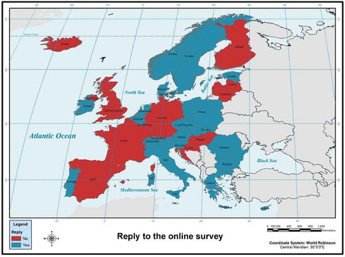
The questionnaire has been answered by 17 SIs (from 28 in total) from EU and 3 SIs (from 4 in total) from EFTA countries. Despite the fact that the online survey has been sent three times in 2017, it was not possible to have answers from all the institutes. presents a map of the replies of the SIs to the online questionnaire of this study.
Figure 2. Reply to the online survey.
A general example of the results that the Typeform platform can produce is presented in .
Figure 3. An example of the produced results by Typeform.
The administrative structure of the SIs which answered the questionnaire is 15 national agencies, 3 state agencies (Slovakia, Czech Republic and Ireland) and 2 federal agencies (Belgium and Switzerland). As it is mentioned, the questionnaire has been sent via email to the employees, of each SI of EU and EFTA countries, who participate in the GISCO committee. Thus, these employees are familiar with geospatial technology. From those, 13 were male and 7 were female. Also, 16 of them are professional GIS users, that is, one who creates GIS applications and/or creates, maintains or edits data; 3 were single users, that is, one who uses GIS applications created by others but does not create or edit data; and 1 was the GIS unit director.
All the above SIs use GIS technology within the SIs. shows from when GIS are used in each SI.
Figure 4. GIS in the SIs of EU and EFTA countries.
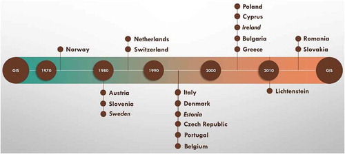
As it is clear, the first SI that used GIS is the Norwegian one. The most recent SI which uses GIS is the Romanian and the Slovakian. Since 1980, the Austrian, the Slovenian and the Swedish SIs use GIS. The majority of the SIs use GIS since the 1990 decade (Italy, Denmark, Estonia, Czech Republic, Portugal and Belgium) and 2000 decade (Poland, Cyprus, Ireland, Bulgaria and Greece). GIS technology in the SI of Liechtenstein has been provided by the official infrastructure.
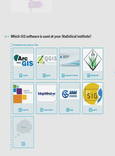
In terms of GIS software, 18 SIs use ArcGIS platform; Slovenian SI use QGIS and MapInfo; the Swedish SI uses ArcGIS, QGIS, MapInfo, FME and Spatial SQL; and the Norwegian and Bulgarian SIs use ArcGIS, QGIS and gvSIG. It is obvious that almost all the SIs use commercial GIS platforms, but during the last years, they have been using more and more free and open platforms like QGIS.
It is understandable that the needs of each institute are different, and in its structure, GIS plays a different role. For this reason, the structure is not the same in all institutes, meaning that the GIS entity within each institute has many forms. Thus, there are six SIs in which GIS entity is set as a unit (Netherlands, Italy, Poland, Portugal, Ireland and Belgium), three SIs in which GIS entity is set as a department (Sweden, Czech Republic and Greece), two SIs in which GIS entity is set as a sector (Norway and Switzerland) and one SI in which GIS entity is set as a division (Romania). The rest of the SIs do not have any specific form for the GIS entity within their structure, but the GIS employees are shared with others departments, units and so on of each SI.
An eventual side effect of the organizational provision of GIS in each institute is also the degree of implementation of GIS in each SI. Thus, there are 11 SIs in which employees make an extensive use of GIS, and from them, 7 SIs have few users (Denmark, Sweden, Netherlands, Austria, Italy, Belgium and Switzerland) and 4 many users (Poland, Czech Republic, Portugal and Norway). Six SIs have few users and applications (Romania, Slovakia, Estonia, Bulgaria, Cyprus and Greece), and Irish SI is in an initial stage of development. A notable fact is that the Slovenian SI is more turning to be provider of geospatial statistics and leaving core GIS processing to the users. Almost all the SIs (except Liechtenstein) have full-time employees in their GIS entities as well as part-time employees.
Geospatial technology is synonymous to linking people for bigger welfares, and geospatial agencies, worldwide, performance a vital role in enabling the implementation of geospatial technologies so as to permit greater efficiency among industries, people and the society in general. Despite that 10 from the SIs that replied to this questionnaire do not have any contract with public entities (universities, state agencies, etc.) or private entities (commercial business, etc.). Three SIs have contract both with public and private sectors (Estonia, Czech Republic and Greece), six SIs have contracts with private entities (Cyprus, Sweden, Poland, Norway, Austria and Switzerland). The SI of Netherlands has contracts only with public entities.
It is widely accepted that GIS data have become an increasingly important data type to organizations and to business in general. Most of the leaders distinguish that an operative GIS data management strategy and governance agenda must address both the short-term requests of present projects and the long-term planned business necessities of an enterprise. In this context, spatial databases play a crucial role for SIs. For an organization, such SI data can be created by the staff within the institute, can be supplied by other national agencies of each country or can be purchased by commercial companies.
Thus, the SIs from Denmark, Austria, Romania and Greece take advantage of all the above ways of having spatial databases. The SIs from Sweden, Belgium, Switzerland, Poland, Czech Republic, Norway, Estonia, Bulgaria and Cyprus create their own data, and other national agencies provide data to them. Another notable fact is that Irish SI is only purchasing data from commercial companies. In terms of data layers, nine SIs have more than 30 GIS data layers (Slovenia, Denmark, Sweden, Italy, Poland, Czech Republic, Portugal, Norway and Romania), two SIs have 21–30 GIS data layers (Austria and Switzerland), three SIs have 10–20 GIS data layers and five SIs have less than 10 GIS data layers (Belgium, Slovakia, Estonia, Cyprus and Greece).
As it is known, data-sets in scope of INSPIRE are ones which come under one or more of the 34 spatial data themes (in three annexes) set out in the INSPIRE Directive. presents the kind of those data layers that each SI is managing.
Table 2. Data layers that each SI manages.
Mapping is a fundamental task of GIS, which affords a graphic explanation of geodata. A GIS platform stores geodata in a database format and then denotes it visually in a mapped format. In this case, all the SIs use GIS technology for mapping needs and purposes. presents what kind of maps each SI is producing.
Table 3. Maps which are produced by each SI using GIS.
As it is clear, all the SIs produce not only statistical maps and demographic maps (except Belgium, Ireland and Liechtenstein), as it is logic (as statistical agencies of each country), but also boundary maps, and Norway is the only SI that produces political maps as well. Despite the fact that all the SIs use GIS for mapping purposes, they do not have (all of them) a WEB-GIS platform to promote their mapping products. Actually, only the SIs from Austria, Estonia, Greece, Ireland, Italy, Netherlands, Norway, Poland, Portugal, Romania, Slovenia and Switzerland provide GIS services through the web (http://www.statistik.at/verkehrsunfallkarte/, https://estat.stat.ee/StatistikaKaart/VKR, http://www.statistics.gr/el/elstat-maps-geo, http://census.cso.ie/sapmap/, http://gisportal.istat.it, http://www.cbsinuwbuurt.nl, http://kart/ssb.no, http://geo.stat.gov.pl, http://geogrid.ine.pt/, http://mapas.ine.pt/map.phtml and http://edemos.insse.ro/portal, http://gis.stat.si, https://www.atlas.bfs.admin.ch/).
Business intelligence (BI) systems offer the capability to evaluate business information in order to provision and expand organization decision-making transversely a wide range of business actions (Elbashir, Collier, and Davern Citation2008). BI systems can also benefit businesses, recognize market tendencies and advert commercial glitches that must be addressed. In this case, seven SIs do not have BI systems (Austria, Belgium, Bulgaria, Cyprus, Czech Republic, Liechtenstein and Romania). The rest of them have BI systems, and they conduct several tasks with it. Some of these tasks are presented in .
Table 4. Tasks that are conducted through BI.
It is obvious that most SIs (with a BI system) take advantage of the capabilities which such a system gives. The Norwegian SI seems to use all the capabilities of its BI system. BI has traditionally been used in administrations as a planned apparatus to exploit earnings. When it is coupled with GIS, it can be altered into a cutting-edge decision support system for development of local and regional areas (Wickramasuriya et al. Citation2013). Nevertheless, only the SIs from Estonia, Ireland, Norway, Poland, Slovenia and Sweden use their BI for mapping and visualizing purposes.
In 2015, countries adopted the 2030 Agenda for Sustainable Development and its 17 sustainable development goals. Stefan Schweinfest, the Director of Statistics Division of UN Department of Economic and Social Affairs (DESA) said that
Geospatial information is a critical component of national infrastructure and a blueprint of what happens where, and with proven societal and economic value. Better understanding and management of digital location-based data and services, and good geospatial information integrated with urban planning and census data, can enable more efficient resource allocation for better service delivery.Footnote2
Since the interaction of human life with the environment has spatio-temporal characteristics, spatial sciences such as GIS and remote sensing (RS) can offer established solutions for combined strategies. Thus, it was necessary to include to the questionnaire some questions about the implementation of RS by the SIs of EU and EFTA countries. The SIs that actually use RS are from Denmark, Italy, Norway, Sweden and Switzerland. Slovenia used RS and especially ERDAS software until 2005, when the LU/LC survey ended. The SI from Denmark uses RS more than 10 years, the Italian SI uses IDRISI software for more than 10 years, as well, while the Norwegian uses RS the last 5 years. The Swedish SI does not use any specific software, but they have built-in algorithms for ArcGIS more than 10 years, and the Swiss SI uses Socket GXP for more than 10 years as well.
Even since 1997, the matter of a European policy framework for geographic information was discussed by Craglia and Masser (Citation1997). Their publication described the developments (up to that date), at the European level, for the creation of a European community for GI and the attempt to establish a relevant policy framework for the development of a European GI infrastructure. Their argument about the importance of this project was met a few years later by the INSPIRE initiative and was further supported by Craglia and Annoni (Citation2007) during the preparatory phase of the Directive. They underlined the innovation of the European SDI project in two aspects, first in the attempt to form the SDI based on existing status at the national and sub-national levels and second in the organization of users and GI stakeholders through structured communities about spatial data.
The INSPIRE Directive initiates an infrastructure to allow the distribution of spatial data and services within the EU in order to support environmental policies. INSPIRE was intended to address five perceptible tasks in relative to environmental policies and data (EC EEA 2014). These are (1) missing or incomplete spatial data; (2) no metadata or description for the spatial data; (3) the incompetence to associate spatial data-sets; (4) the lack of systems to find, access and use spatial data harmonious with other data-sets; and (5) cultural, institutional, financial and legal barriers that prohibited and overdue the distribution and reclaim of prevailing spatial data (Cho and Joep Crompvoets, Citation2018).
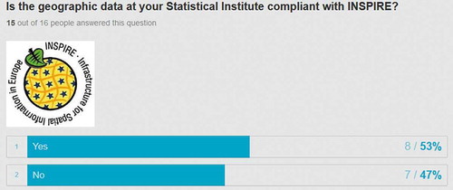
The SIs that responded to this survey are not compliant at the same level with the INSPIRE Directive. Especially, the SIs of Belgium, Bulgaria, Cyprus, Italy, Portugal and Romania are in the stage of ‘Discovery metadata are available for spatial data sets and services’; the SIs of Ireland, Denmark and Slovakia are in the stage of ‘Spatial data sets are available for discovery and view from the INSPIRE geoportal’; the SI of Switzerland is in the stage of ‘Discovery metadata are available for spatial data sets and services’; the SIs of Austria, Estonia, Netherlands, Norway, Czech Republic and Sweden are in the stage of ‘Spatial data sets are available for download and transformation from the INSPIRE geoportal’; and, finally, the SI of Poland is in the stage of ‘All spatial data sets are conformant to IR-ISDSS and available through network services’. Here, a notable fact is that the SI of Slovenia is not primarily responsible for any of the sources described in the INSPIRE data themes and is, therefore, not directly involved in the ISNPIRE implementation.
A fruitful census preparation procedure needs wide discussions with the key users of the data that will be created in the census. This procedure must comprise discussion on spatial content, that is, spatial structures, counting administrative pyramids and also on spatial base produces that provision the study of census data. The welfares of geographic data computerization in statistics are shared by the manipulators of census and survey data. Data assimilation tasks provided by GIS, which permit the associating of information from numerous diverse subject parts, have directed to a greatly broader use of statistical information. This has augmented the stress on the SIs to produce high-quality spatially referenced data for smaller spatial units (UN DESA Citation2013).
One of the major tasks of this study is how geospatial technology is used for Population and Housing Census purposes. shows how often census has been conducted in countries of EU and EFTA zone and what is the use of geospatial technologies at the pre-enumeration, enumeration and at the stage post-enumeration of a census.
Table 5. Census frequency and use of geospatial technology during census.
Discussion
The fast latest progresses in digital mapping and spatial analysis technology and the growing request for georeferenced smaller area population information linger to be the key impetus for organizations worldwide. Any country boarding on a census plan will prerequisite to design lengthily to reduce the budgets and maximize the welfares from the obligatory mapping actions. Censuses remain to be one of society’s greatest significant tools in order to comprehend human populations methodically. Geospatial technology has distorted the way that data can be offered for public advantage and for the raise of social, economic and maintainable growth. GIS assurances quantifiable efficiency increases in nearly any business, using the consolidating vital belief of geography that space and place matter (UN DESA Citation2008).
It is commonly accepted that a GIS system consists of software, hardware, data, methods and people. This scheme should also apply to the SIs. It is necessary to understand the earned value of adopting and using the geospatial technology. But in order to gain the benefits of GIS technology, the best way is to have in harmony all the above factors of a GIS system. Hence, from this study, it is concluded that SIs in EU and EFTA countries have four factors (software, hardware, methods and data). All the SIs have implemented GIS many years ago (the majority of them). Depending on their needs, each SI has included GIS entity within a sector, a unit, a department, and so on. The problem that arises is that in terms of people, there are SIs with many employees-users of GIS and some other with none. It is fundamental to realize that GIS users, and in fact advanced GIS users, can turn SIs to more productive agencies. Another fact, which is linked to the previous one, is that there are a lot of SIs that do not have a GIS portal. Advanced IT and GIS users can cooperate to create web portals at no cost using the free and open technology.
In addition, most of the SIs create their own data, which is a sign of maturity in terms of GIS applications, while some others make contracts with other public agencies in order to supply to them data, or they purchase data by commercial companies. In fact, the majority of the SIs has data layers such as statistical units, administrative units, addresses and buildings, which is logic due to census purposes. Many of them are managing more than 30 data layers within their GIS (Slovenia, Denmark, Sweden, Italy, Poland, Czech Republic, Portugal, Norway and Romania).
Together with GIS, many SIs have implemented BI systems for a variety of analyses such as crosstab analysis, drill-though analysis, dashboard (multiple metrics presented visually), scorecard (one metric compared to target), data mining and predictive analytics, OLAP, structured query language (SQL), extract/transform/load data (ETL), plain reports and for mapping purposes as well (Estonia, Ireland, Norway, Poland, Slovenia and Sweden). Only few of the SIs have implemented RS for their needs, despite the fact that these data can now be retrieved online, using a variety of applications. The benefit of using these data salvage versus purchasing RS imagery is that SIs can test the applicability of imagery without any further investment. Surplus remotely sensed data can be used on GIS in order to correct spatial databases.
As it is already mentioned, INSPIRE Directive is fundamental as it ‘aims to create a European Union spatial data infrastructure for the purposes of EU environmental policies and policies or activities which may have an impact on the environmentFootnote3’. There are a lot of actions taken by the EU in order for all the Member States and their organizations to comply with the INSPIRE Directive. Nevertheless, this study showed that the state of implementation still displays dissimilar levels of maturity across the SIs which is in line to the ‘Summary Report on Status of implementation of the INSPIRE Directive in EU’ by JRC (2017). Depending on this last report, EC will take the suitable actions to increase national energies during the next years (Cetl et al. Citation2017).
The INSPIRE Directive, as it is stated, commences an infrastructure in order to all EU Member States to have the same mechanism of distribution of spatial data and services, to support policies. This is critical in terms of the Directive implementation, and it is one of its main aspects. The implementation of the Directive by all the SIs will give the option to have all European spatial data available for research purposes, for adopting the right policies for the future of EU.
Most of the countries and, therefore, the SIs conduct the traditional Population and Housing Census. Taking into account the received replies, only 4 countries (from 20 that replied) have registered-based system for population census purposes. The rest are conducting a census every 10 years (except Ireland and Liechtenstein which conduct census every 5 years and Switzerland which conducts census every year). During the pre-enumeration stage, GIS is used mainly for geocoding, digital mapping and database census preparation. During the enumeration stage, GIS is used for mapping purposes and as remarkable point for mobile devices (by the Polish SI). Similarly, during the post-enumeration stage, GIS is used mainly for updating statistical databases, mapping and internet mapping and data dissemination as many SIs have incorporated the web as a means to disseminating information and data.
It is in the knowledge of the authors that the present research finds an inadequacy. This lacks 30% of response of the SIs. This research would be more complete if all the SIs responded. This was impossible despite the fact that the questionnaire was sent three times to the respondents’ emails.
It is a fact that the development for the operative implementation of a GIS cannot happen very fast. And this is because it needs a lot of time to incorporate sophisticated systems in an organization. For the census, extremely comprehensive maps will always be needed for the enumerators. Thus, the need for implementation of geospatial technology is granted.
Disclosure statement
No potential conflict of interest was reported by the authors.
Notes
1. The questionnaire is available via https://gisonstatisticssurvey.typeform.com/to/t40HlD .
Related Research Data
References
- Andrews, D., B. Nonnecke, and J. Preece. 2003. “Electronic Survey Methodology: A Case Study in Reaching Hard to Involve Internet Users.” International Journal of Human-Computer Interaction 16 (2): 185–210. doi:10.1207/S15327590IJHC1602_04.
- Bartha, G., and S. Kocsis. 2011. “Standardization of Geographic Data: The European Inspire Directive.” European Journal of Geography 2 (2): 79–89.
- Boes, U., and R. Pavlova. 2008. “Is There a Future for Spatial Data Infrastructures.” In Proceedings GI-Days. Muenster, Germany.
- Borzacchiello, M. T., and M. Craglia. 2012. “The Impact on Innovation of Open Access to Spatial Environmental Information: A Research Strategy.” International Journal of Technology Management 60 (1–2): 114–129. doi:10.1504/IJTM.2012.049109.
- Cetl, V., V. Lima de, N. Tomas, R. Lutz, M. D’Eugenio, J. Nagy, and A. Robbrecht, J. 2017. Summary Report on Status of implementation of the INSPIRE Directive in EU, EUR 28930 EN. Luxembourg: Publications Office of the European Union.
- Cetl, V., K. Tóth, and P. Smits. 2014. “Development of NSDIs in Western Balkan Countries in Accordance with INSPIRE.” Survey Review 46 (338): 316–321. doi:10.1179/1752270614Y.0000000120.
- Cho, G., and J. Crompvoets. 2018. “The INSPIRE Directive: Some Observations on the Legal Framework and Implementation.” Survey Review 1–8. doi:10.1080/00396265.2018.1454686.
- Craglia, M., and A. Annoni. 2007. “INSPIRE: An Innovative Approach to the Development of Spatial Data Infrastructures in Europe.” In Research and Theory in Advancing Spatial Data Infrastructure Concepts, 93–105.
- Craglia, M., and I. Masser. 1997. “A European Policy Framework for Geographic Information. Computers.” Environment and Urban Systems 21 (6): 393–406. doi:10.1016/S0198-9715(98)00010-6.
- Crompvoets, J., A. Bregt, A. Rajabifard, and I. Williamson. 2004. “Assessing the Worldwide Developments of National Spatial Data Clearinghouses.” International Journal of Geographical Information Science 18 (7): 665–689. doi:10.1080/13658810410001702030.
- De Jong, A. J. 2015. “Geographic Data as Personal Data in Four EU Member States.” Master diss. TU Delft.
- Elbashir, M. Z., P. A. Collier, and M. J. Davern. 2008. “Measuring the Effects of Business Intelligence Systems: The Relationship between Business Process and Organizational Performance.” International Journal of Accounting Information Systems 9 (3): 35–153. doi:10.1016/j.accinf.2008.03.001.
- ESRI. 2011. ArcGIS for INSPIRE. Handbook. Redlands: ESRI.
- Evans, J. R., and A. Mathur. 2005. “The Value of Online Surveys.” Internet Research 15 (2): 195–219. doi:10.1108/10662240510590360.
- Gallego, F. J. 2011. “Validation of GIS Layers in the EU: Getting Adapted to Available Reference Data.” International Journal of Digital Earth 4 (1): 42–57. doi:10.1080/17538947.2010.512746.
- Gie, M., and J. Hwan. 2017. “A Comparative Study on the NSDI Assessment.” Journal of the Korean Society of Surveying, Geodesy, Photogrammetry and Cartography 35 (5): 375–387.
- Giff, G., B. Van Loenen, J. W. H. C. Crompvoets, and J. Zevenbergen. 2008. “Geoportals in Selected European States: A Non-Technical Comparative Analysis.” In Conference, Small Island Perspectives on Global Challenges: The Role of Spatial Data in Supporting a Sustainable Future Location. St. Augustine, Trinidad.
- Guin, T. D.-L., R. Baker, J. Mechling, and E. Ruyle. 2012. “Myths and Realities of Respondent Engagement in Online Surveys.” International Journal of Market Research 54 (5): 613–633. doi:10.2501/IJMR-54-5-613-633.
- Harvey, F., and D. Tulloch. 2006. “Local‐Government Data Sharing: Evaluating the Foundations of Spatial Data Infrastructures.” International Journal of Geographical Information Science 20 (7): 743–768. doi:10.1080/13658810600661607.
- Lemmens, M. J. 2001. “An European Perspective on Geo-Information Infrastructure (GII) Issues.” In Proceedings of the Workshop National Geospatial Data Infrastructure: Towards a Roadmap for India, 2001. New Delhi.
- Makridou, D. A. 2010. “Compatibility Study of the Spatial Data of the National Cadastre with the European INSPIRE Directive.” Master diss. Aristotle University of Thessaloniki, School of Rural and Surveying Engineering.
- Miller, C. 2009. “Respondent Technology Preferences.” In CASRO Technology Conference. New York.
- Pashova, L., and T. Bandrova. 2017. “A Brief Overview of Current Status of European Spatial Data Infrastructures− Relevant Developments and Perspectives for Bulgaria.” Geo-Spatial Information Science 20 (2): 97–108. doi:10.1080/10095020.2017.1323524.
- Rajabifard, A., M. E. F. Feeney, and I. P. Williamson. 2002. “Future Directions for SDI Development.” International Journal of Applied Earth Observation and Geoinformation 4 (1): 11–22. doi:10.1016/S0303-2434(02)00002-8.
- Smith, R. S., L. Bargiotti, N. Loozen, S. Goedertier, M. Rovera, and L. H. Quirós. 2015. “Capacity-Building across Sectors: Making a Reference Platform for INSPIRE Implementation, Interoperability and Reusability.” In eChallenges E-2015 Conference, Vilnius, Lithuania, 2015. IEEE, New York, USA.
- UN DESA. 2008. “Handbook on Geospatial Databases and Census Mapping, (Draft Version).” United Nations Expert Group Meeting on Measuring the Economically Active Population in Censuses 7-10 April 2008, New York.
- UN DESA 2013. Handbook on Geospatial Infrastructure in Support of Census Activities, Studies in Methods (Ser. F), No. 103 European Commission, Brussels.
- United Nations. 2008. Handbook on Geographic Databases and Census Mapping. New York: Department of Economic and Social Affairs Statistics Division.
- United Nations. 2009. Handbook on Geospatial Infrastructure in Support of Census Activities. New York: Department of Economic and Social Affairs Statistics Division.
- Vancauwenberghe, G., D. Vandenbroucke, J. Crompvoets, F. Pignatelli, and R. Boguslawski. 2014. “Assessment of the Integration of Geographic Information in E-Government Policy in Europe.” In Connecting a Digital Europe through Location and Place. Proceedings of the AGILE’2014 International Conference on Geographic Information Science, edited by J. Huerta, S. Schade, and C. Granell. Castellón, June, 3–6.
- Wickramasuriya, R., P. Perez, J. Ma, and M. Berryman. 2013. “Adapting Geospatial Business Intelligence for Regional Infrastructure Planning.” In 20th International Congress on Modelling and Simulation. Adelaide, Australia, December, 1–6.