Abstract
The climate change of the 20th century has had a pronounced effect on glacier environments of the Himalayas. The formation of moraine dammed glacial lakes and outburst floods from such lakes are a major concern in countries such as Bhutan, Tibet (China), India, Nepal and Pakistan. The hazardous lakes, however, are situated in remote areas and are very difficult to monitor through ground surveys due to the rugged terrain and extreme climatic conditions. This paper depicts the growth of a glacial lake in Reru Valley, Zanskar Himalaya based on the observations made from temporal satellite data. The change detection studies show the glacier retreating at an average rate of 12 m per year, causing lateral growth of the lake. Peak discharge from the lake is estimated using empirical formulas and varies from 1.7 m3 s−1 to 196 m3 s−1.
1. Introduction
Mountain glaciers interact sensitively with climate and therefore they are considered as climate indicators (Oerlamans 1994). The changing climate has had a significant impact on the accelerated retreat of many glaciers globally. Warmer climates of the past 100 to 150 years have resulted in widespread glacial retreat and the formation of glacial lakes in many mountain ranges (Clague and Evans 1994, Nakawo et al. 1999).The sudden catastrophic discharge of large volumes of water is characteristic of many steep mountain regions. Such discharges are usually the result of the collapse of unstable natural dams/ice that block lakes. The lakes, located at the snout of the glacier, are mainly dammed by the lateral or end moraine, where there is a high tendency of breaching. Such lakes could be dangerous as they may hold a large quantity of water. Breaching and the instantaneous discharge of water from such lakes can cause flash floods, enough to create enormous damage in the downstream areas.
Glacial lake outburst floods (GLOFs) can be produced by water reservoirs existing in front, or at the surface, base, or margins of glaciers (Haeberli 1983). These floods can cause extensive damage to the natural environment and human property as they can drain extremely rapidly and small lakes can cause dramatic floods (Desloges et al. 1989). As per the International Centre for Integrated Mountain Development (ICIMOD) inventory there are 8790 glacial lakes in Bhutan, Nepal and selected areas of China, India and Pakistan (Ouyang Hua 2009) and such flash floods are a common problem in these countries. Most of the glacial lakes in the Himalayan region are known to have formed within the last 5 decades, and a number of GLOF events reported in this region have trans-boundary impacts. depicts some of the selected GLOFs recorded in the Himalayan region.
Table 1. List of some of the recorded major glacial lake outburst flood (GLOF) events in the Himalayan region. (Source: Richardson and Quincey 2009 and Bajracharya et al. 2006.)
The GLOF event in Nepal during 1981 damaged the Friendship Bridge of the China-Nepal Highway, destroyed the Koshi power station in Nepal and caused serious economic losses (Bajracharya et al. 2006). During August 2000, in the Tibetan Plateau, a GLOF occurred and destroyed more than 10 000 houses, 98 bridges and the financial losses were about 75 million US dollars (Shen 2004). In 2008, a GLOF from Gulkin glacier, Karakoram Himalayas also damaged many properties (Richardson and Quincey 2009). The GLOFs at Dig Tsho in 1985 (Nepal) and Luggye Tso in 1994 (Bhutan) are considered ‘textbook’ case studies of GLOF events studied globally.
In the Indian Himalayan region the first GLOF event was reported by Mason in 1929. He reported that in 1926 a flood was released by the Shyok glacier, Jammu and Kashmir, which destroyed the village of Abudan and the surrounding land at a distance of 400 km from the outburst source (Mason 1929). Another report by Sangewar et al. (1999) depicted sudden emptying of some of the moraine dammed lakes of Shaune Garang glacier, Himachal Pradesh in 1981 and 1988, based on high discharge measured downstream. The International Centre for Integrated Mountain Development (ICIMOD) data provided a first level assessment of lakes in some parts of the Indian Himalayan region (Bajracharya et al. 2006) and a compiled list of some of the glacial lakes in the Indian Himalaya is given in . Randhawa et al. (2005) studied the moraine dammed glacial lakes in Chenab and Satluj basin using Indian Remote Sensing (IRS) satellite data and estimated the discharge. Remote sensing is found to be one of the best tools for identifying such glacial lakes and offers strong advantages for rapid and qualitative hazard assessments of glacier lakes. This paper presents a case study of the growth of a glacial lake formed in the Zanskar basin of Jammu and Kashmir Himalaya identified through temporal satellite data and assessment of discharge from the lake.
Table 2. List of some of the glacial lakes in Indian Himalaya. (Source: Bajracharya et al. 2006, Kulkarni 1996a, Randhawa et al. 2005b.)
2 Study area
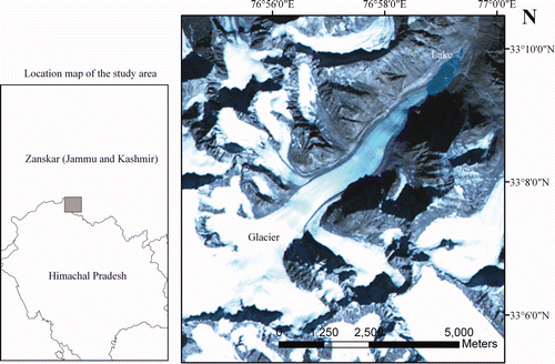
The glacial lake (33° 09′ 32.56″ N, 76° 59′ 05.38″ E) located in the Zanskar basin, Jammu and Kashmir, situated at an elevation of 4500 m is attached to the snout of the glacier (no name exists) from which Reru stream originates. The glacier melt water in the lake acts as the source of the drainage for Reru stream, which is a tributary of Tsarap Lingti Chu river in Zanskar basin. The glacier is a compound valley glacier orienting NE with a well developed valley. The location map of the study area is shown in .
Figure 1. Location map of the study area showing the glacier and the glacial lake.
3 Data used
Landsat Multispectral Scanner (MSS), Thematic Mapper (TM), Enhanced Thematic Mapper Plus (ETM+) and Resourcesat-1 (IRS P6) Linear Imaging Self Scanning (LISS) III satellite data were used in this study. Apart from the satellite data topographic map (1953) of 1:250 000 scale prepared by the Army Map Service and Advanced Spaceborne Thermal Emission and Reflection Radiometer (ASTER) Digital Elevation Model (DEM) from the Earth Remote Sensing Data Analysis Center (ERSDAC) was also used. illustrates the details of the data used in the present study and the area of the lake is derived from temporal satellite data.
Table 3. Details of the satellite data used in the present study and area (km2) of the lake derived from satellite data.
4 Methodology
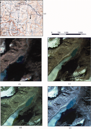
For this study a topographic map, prepared by the Army Map Service in 1953, was used as the base data. The present lake is not mapped on the topographic map, hence it is assumed that the lake formed after 1953. The first occurrence of the lake is marked in the Landsat MSS data of 1975 and the lake areal extent is mapped from the Landsat MSS data (). In 1975 the lake had an aerial extent of 0.17 km2 and the lake is attached to the glacier terminus. The areal extent of the lake is also mapped from temporal satellite data from 1989, 2000 and 2005. The lake area increased 0.25 km2 from 1975 to 2005.
Figure 2. Maps showing the glacial lake at different time periods. (a) 1953 topomap of the glacier. Satellite data showing the growth of the glacial lake in (b) 1975, (c) 1989, (d) 2000 and (e) 2005.
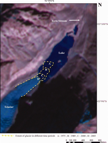
The glacier boundary is also mapped from Landsat TM (1989), Landsat ETM+ (2000) and Resourcesat 1 LISS III (2005) data. The glacier boundary is delineated from satellite data using standard false colour composite (FCC) combination of bands and image enhancement techniques applied to differentiate glacial and non-glacial features. The glacier retreat measurements were carried out along the maximum length of the glacier. The change detection study revealed the glacier retreated 451 m during the 30-year period (1975–2005). shows the extent of glacier at different time periods and the retreat of the glacier. The 2005 satellite imagery shows that the lake is still attached to the snout but expanding laterally and is increasing in areal extent.
Figure 3. The retreat map of the glacier at different time periods (1975, 1989, 2000, 2005).
The depth measurements of the lake were carried out using an ASTER DEM. Lake depth measurements were derived from the contour map generated from the ASTER DEM. The shore height of the lake and the centre part of the lake are utilized for calculating the depth of the lake. As per these parameters utilized for depth estimation, the depth of the lake is taken to be approximately 10 m to simplify the further calculations on discharge. The areal extent of the lake is measured as 0.42 km2 in the year 2005. The volume of the lake is estimated as the product of the area, depth and volume, thus derived is 4.2 million m3.
The magnitude of a flood caused by the breach of a moraine dam is relevant for further risk analyses. A variety of empirical equations have been developed by various researchers used for estimating the maximum instantaneous discharge Q max (). The parameter mainly used in these equations is the volume of the lake in m3.
Table 4. List of models used for estimation of maximum discharge (Qmax).
The estimation of discharge from the lake is calculated using empirical formulas (). For all the formulas the lake volume is assumed to be 4.2 million m3 and the average depth is 10 m. The resultant maximum instantaneous discharge from the lake is given in . Subsequent to the development of the above formulas many physically based models were developed to estimate peak discharge. Due to non-availability of other parameters such as ice thickness, lake temperature, length of drainage tunnel, bathymetry of the lake, it is difficult to apply such models to this kind of investigation. Therefore, the above mentioned models are used for initial assessment of lake discharge and risk analysis.
5 Results and discussion
As mentioned in the methodology section, the maximum possible lake volume is 4.2 million m3 (latest by 2005 data), and the lake depth is 10 m; the peak discharge is estimated using the formulas (). Each empirical relation gives a unique discharge value and is given in . According to the equations the resultant discharge ranges from 1.7–196 m3 s−1. By taking the maximum lake volume in 2005 the estimated maximum peak discharge is 196 m3 s−1 using the model of Clague and Mathews (1973). This value of lake discharge is very high considering the average summer discharge of Chhota Shigri nala in Himachal Pradesh, which is 10 m3 s−1 (Kulkarni 1996). But considering any other model, the discharge rate is very low. The error in the model is not estimated due to lack of field data.
Two assumptions are made out of the discharge results. Assumption 1: if the discharge is greater than 60 m3 s−1 then the lake has potential for GLOF. Assumption 2: If the discharge is less than 60 m3 s−1 then the lake has no potential for GLOF. These assumptions are made out of the statistical analysis of the discharge results. But such natural hazards are non predictable and may have trans-boundary impacts also. In the Indian Himalayan region flash flooding, resulting from sudden downpours due to cloudburst, is very common in the monsoonal season. The formation of cloudburst over the present glacial lake region can cause dangerous GLOFs.
In the case of the present glacial lake, it has been observed that the lake has grown laterally from 1975 to 2005, and the glacier receded by 451 m during the observed span of 30 years. In future, the lake may occupy more areas of the eroded glacier valley and may form a separate moraine-dammed lake.
6 Conclusion
Glacial lake outburst floods (GLOFs) can be considered a geomorphological risk because they are natural risks connected to a geomorphological hazard. The methods proposed here are intended to enable rapid hazard assessments over large areas of glacier lakes in remote inaccessible high mountain regions. Lake area and volume are of primary importance since they define the amount of water available for an outburst. This study indicates that the lake was formed after 1953 and its dimensions are continually changing due to the glacier retreat. The rate of growth of the lake indicates possible developments of the hazard situation. Change detection techniques based on satellite image time series are especially useful in such cases.
This paper presents the potentials of temporal remote sensing datasets for detecting and monitoring the hazardous nature of glacial lakes in the highly glaciated terrain of the Indian Himalaya. Empirical models applied using remote sensing data allowed an approximate estimation of a potential GLOF hazard. If the preliminary study indicates a severe hazard potential, a more detailed field survey may be required to establish the risk of GLOF. In view of the fast retreating glaciers in the Himalaya and to establish the hazard potential of glacial lakes a systematic inventory of glacial lakes using high resolution satellite data and in situ field survey is recommended and adaptation measures such as early warning systems and mitigation measures are required for potentially sensitive GLOF areas. The study recommends the water storage capacity of these lakes may be managed in such a fashion that is augmented to reduce the impact of disaster.
Acknowledgments
The author would like to thank the Director, NRSC and Deputy Director (RS & GIS), NRSC for providing support during the course of work. Sincere thanks to Dr K. Vinod Kumar and Shri Arindam Guha for suggestions and comments to improve the manuscript. Sincere thanks to the anonymous reviewers for the constructive comments and thanks to GLCF, University of Maryland, USA for the Landsat MSS, TM and ETM+ data.
Related Research Data
References
- Bajracharya , R. S. , Mool , P. K. and Shrestha , B. R. The impact of global warming on the glaciers of the Himalaya . Proceedings of the International Symposium on Geo-disasters, Infrastructure Management and Protection of World Heritage Sites . November 25–26 . pp. 231 – 242 . Kathmandu: Nepal Engineering College, National Society for Earthquake Technology Nepal, and Ehime University, Japan
- Clague , J. J. and Evans , S. G. 1994 . Formation and failure of natural dams in the Canadian Cordillera . Geological Survey of Canada Bulletin , 464 : 35
- Clague , J. J. and Mathews , W. H. 1973 . The magnitude of Jökulhlaups . Journal of Glaciology , 12 : 501 – 504 .
- Desloges , J. R. , Jones , D. P. and Ricker , K. E. 1989 . Estimation of peak discharge from drainage of ice-dammed Ape lake British Columbia, Canada . Journal of Glaciology , 35 : 349 – 354 .
- Evans , S. G. 1986 . The maximum discharge of outburst floods caused by the breaching of man-made and natural dams . Canadian Geotechnical Journal , 23 : 385 – 387 .
- Haeberli , W. 1983 . Frequency and characteristics of glacier floods in the Swiss Alps . Annals of Glaciology , 4 : 85 – 90 .
- Huggel , C. , Kääb , A. , Haeberli , W. , Teysseire , P. and Paul , F. 2002 . Remote sensing based assessment of hazards from glacier lake outbursts: a case study in the Swiss Alps . Canadian Geotechnical Journal , 39 : 316 – 330 .
- Kulkarni , A. V. 1996 . Moraine-dammed glacial lake studies using remote sensing technique . Himalayan Geology , 17 : 161 – 164 .
- Mason , K. 1929 . Indus floods and Shyok glaciers . Himalayan Journal , 1 : 10 – 29 .
- Nakawo , M. , Yabunk , H. and Sakai , A. 1999 . Characteristics of Khumbu Glacier, Nepal Himalaya: recent changes in debris-covered area . Annals of Glaciology , 28 : 118 – 122 .
- Oerlamans , J. 1994 . Quantifying global warming from the retreat of glaciers . Science , 264 : 243 – 245 .
- Ouyang , Hua . 2009 . The Himalayas—water storage under threat . Sustainable Mountain Development , : 60 No. 56, ICIMOD
- Popov , N. Assessment of glacial debris flow hazard in the north Tien-Shan . Proceedings of the Soviet-China-Japan Symposium and Field Workshop on Natural Disasters . September 2–17 . pp. 384 – 391 . Shanghai, Lanzhou, Urumgi, Alma-ata, Dushanbe and Kazselezashchita, USSR
- Randhawa , S. S. , Sood , R. K. , Rathore , B. P. and Kulkarni , A. V. 2005 . Moraine-dammed lakes study in the Chenab and the Satluj river basins using IRS data . Journal of the Indian Society of Remote Sensing , 33 : 285 – 290 .
- Richardson , S. D. and Quincey , D. J. 2009 . “ Glacier outburst floods from Ghulkin Glacier,Upper Hunza Valley, Pakistan ” . In Geophysical Research Abstracts Vienna, , Austria 11, EGU2009-12871, EGU General assembly, 19–24 April 2009
- Sangewar , C. V. , Srivastava , D. and Singh , R. K. Reservoir within the Shaune Garang glacier, district Kinnaur, Himachal Pradesh . Abstract Proceedings of the Symposium on Snow, Ice and Glaciers: A Himalayan Perspective. Geological Survey of India . pp. 39 – 40 .
- Shen , Y. 2004 . “ An overview of glaciers, retreating glaciers and their impact in the Tibetan Plateau ” . In Chinese Academy of Sciences (CAS) Report 42