Abstract
Wadi El Arish is the largest drainage system in Sinai Peninsula, Egypt. The wadi was subjected to severe thunderstorms on 17 and 18 January 2010 followed by extreme violent flood that had not been known in Sinai since 1980. The flood claimed six victims, injured tens and devastated vital infrastructure and hundreds of houses. Hydrologic characteristics of the wadi are not fully understood due to the great lack of the detailed hydro-meteorological information. Hence, remote sensing and geographic information system (GIS) techniques were widely used to provide better spatial understanding of storm rain characteristics and drainage basin response. The study was based on the analysis of the TRMM images and the averaged six hourly HYDIS data for storm rain analysis. Hydrological model was constructed using ASTER digital elevation models (DEMs). The empirical black model box was used depending on the curve number approach to predict stream runoff. Landcover and hydrological soil groups were identified from the Landsat ETM+ mosaic using multispectral supervised classification. The curve numbers were adjusted to ARC I (dry condition) as the total rain in five-day period preceding the storm was very low (≤5 mm). The study deduced that the wadi received a total rain volume of 665.4 × 10⁶ m3. Most of the rain fell on 17 January with an intensity ranged between 4–8 mm/hr. The estimated total surface runoff Q was 123.3 × 103 mm and the total runoff volume was 124 × 106 m3 that constitutes 18.8% of the total rain volume. The results are in agreement with the observed values in the wadi, and highly required for many applications related to water harvesting and flood protection studies.
1. Introduction
Approximately half of all environmental disasters, and over two-thirds of disaster deaths, are weather and climate related (Smith and Petley Citation2009). They can constitute a direct hazard to human welfare. Severe storms accompanied by flash floods are very common hazards as over 3000 disasters were recorded by the Centre for Research on the Epidemiology of Disasters since 1900 (available at http://www.cred.be). So far, several societies are still vulnerable to flash floods despite the proliferation of advanced technologies. Therefore, flash floods are continuing to claim lives of many people all over the world and cause serious damage to property, infrastructure and incur economic losses (Colombo et al. Citation2002).
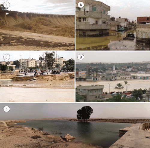
On 17 and 18 January 2010, severe flash floods battered Sinai Peninsula, Egypt owing to heavy rains from which flood of wadi El Arish was the worst. The flood led to the death of six victims and dozens of people were wounded and many missing. It fully devastated 592 houses and partially damaged 1487 houses as the water level reached 2 m above the surface of the ground. The water washed away cars, autotrucks, trees, roads and electric and water lines (). Two tragic movies have been telecasted all over the world on 19 January 2010. One showed the collapse of a four floor-building because of the flowing water. The other showed a washed away oil autotruck while the driver was trying to cross the wadi. These videos would remain as concrete proofs of one of the most horrible flash floods in such an arid environment that had not been known in Sinai since 1980. Damages were estimated as 137 million Egyptian pounds (Official governmental spokesman, personal communication 2010).
Figure 1. (a) Commencement of water flow over El Ruaffa Dam; (b–d) inundation of vast areas of El Arish city; and (e) the ephemeral lake in the front of El Ruaffa Dam.
Rain variability over time and space associated with misdistribution of climatic stations and lack of rain gauges make it difficult to estimate the flood magnitude accurately. Often, rainfall data are not readily available. Even if it is obtainable, it represents the mean daily rainfall that is inadequate to understand or monitor the very short-term flood generation processes in the region. Therefore, satellite real time rainfall data was integrated with GIS to overcome the great lack of information. The main objective of the study is to provide better spatial understanding of storm rain characteristics and drainage basin response. The results are highly required for many applications related to water harvesting and further flood protection studies.
2. Study area
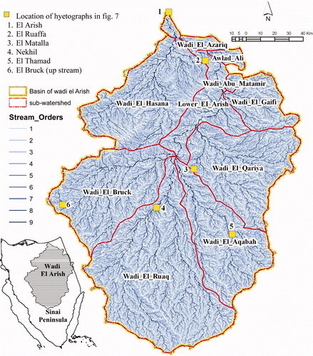
Wadi El Arish is the largest drainage system in Sinai Peninsula, Egypt, covering 21,700 km2 that forms about 36% of the total area of the Peninsula. The trunk stream flows generally to the north for about 363 km from lat 28° 59′ N to its outlet in the Mediterranean at lat 31° 09′ N. Its watercourses are mainly from Sinai and a few other effluents descend from the neighbouring Negev Desert. Drainage network is organized in a dendritic-like pattern (). No significant flow into the sea occurs in most years, but when it does it can be impressive (Greenwood Citation1997) and the wadi looks like a real river (Hamdan Citation1980, El Husseini Citation1987).
Figure 2. Wadi El Arish and its location in Sinai Peninsula, Egypt.
Delta of wadi El Arish is increasingly inhabited after the Israeli withdrawal from the Sinai Peninsula in 1979 as a great amount of attention has been directed towards the establishment of agricultural and industrial projects in wadi El Arish (E1-Bihery and Lachmar 1994). Unfortunately, this development is threatened by infrequent flash floods. The hydrologic characteristics of the wadi are not fully understood due to lack of the detailed hydro-meteorological information. Means of flood control were imperative long time ago to provide adequate protection for the settlements, hence the Ruaffa Dam was constructed in 1946 some 50 km to the south of El Arish City, to hold 3 × 10⁶ m3 of water (Botrous Citation1960). The storage capacity of the dam has been increased in 1987 to hold 5.5 × 10⁶ m3 of water. Nevertheless, the city was prone to several flash floods of different magnitudes (). The destruction caused by the flash floods in January 2010 revealed the necessity to understand the hydro-meteorological characteristics of the wadi to improve means of flood protection.
Table 1. Historical records of flash floods in wadi El Arish (1925–2010).
Analysis of geologic and topographic maps of scale 1:250.000, Landsat ETM + images and DEMs revealed that wadi El Arish attains most of its water courses from the gentle backslopes of El Egma and El Tih Plateaus in Central Sinai. El Egma Plateau is higher than El Tih Plateau since the highest point in El Egma is 1647 m a.s.l whereas the highest point in El Tih is 1400 m a.s.l. The plateaus are composed mainly of Cretaceous and Eocene rocks (i.e. Nubian Sandstone, white chalk and limestone). The strata dip regionally in a northward direction at a very low angle and are locally dissected by minor faults and basaltic dykes (Abd-El Monsef Citation1991). In the central part, the wadi crosses over the Northern Sinai anticlines (e.g. Jabals Halal, Dalfa and Mitmitni) through some gorges of which gorge of El Daiyaga (the Narrow) is the most conspicuous. Between El Daiyaga and the Mediterranean, the wadi maintains its water course through the North Sinai Sand Plain without receiving any significant tributaries.
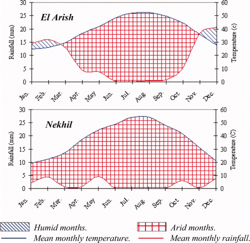
Investigation of the meteorological normals from 1995 to 2002 clarified that the mean monthly maximum temperature varies between 24.2°C and 24.5°C in El Arish and Nekhil, respectively and the mean monthly minimum temperature ranges between 12.5°C and 9.5°C in the same order. The mean annual rainfall hardly exceeds 10.6 mm in El Arish and 2.3 mm in Nekhil, while the mean annual evapotranspiration varies from 3.9 to 6.1 mm/day in the same manner. So, the area experiences hot dry summer and mild rainy winter. According to UNEP (Citation1997), the coastal strip falls into arid region and the massif plateaus belong to hyperarid region. Representation of precipitation and temperature in the ratio of 2 to 1 according to Walter and Lieth (1967) reveals that the dry months are as long as 8.5 months in El Arish and 12 months in Nekhil ().
Figure 3. Climatograms indicating length of the dry season.
3. Data and methods
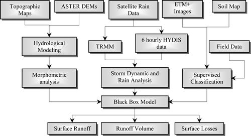
Different data and methods were used in this study as summarized in . The basic approach was to have real time satellite coverage for the rainy storms during 12, 17, 18 and 19 January 2010 in particular. For that purpose, the study depends on the analysis of the Tropical Rainfall Measuring Mission daily images available at: http://precip.gsfc.nasa.gov/rain_pages/daily_choice.html; and the averaged six hourly data obtained from Hydrological Data and Information System (HYDIS) precipitation mapping server available at: http://hydis8.eng.uci.edu/hydis-unesco. These real time satellite images have led to the expansion of our understanding of storm dynamic.
Figure 4. Study scheme.
The TRMM data is a joint US–Japan satellite mission launched on November 1997. It has been designed to monitor tropical precipitation using the Precipitation Radar (PR) and to estimate its associated latent heating. Adjusted merged-infrared (IR) precipitation and root-mean-square (RMS) precipitation-error are estimated using the 3B42 algorithm that consists of two separate steps. The first step uses the TRMM VIRS and TMI orbit data (TRMM products 1B01 and 2A12) and the monthly TMI/TRMM Combined Instrument (TCI) calibration parameters (from TRMM product 3B31) to produce monthly IR calibration parameters. The second step uses the derived monthly IR calibration parameters to adjust the merged-IR precipitation data, which consists of GMS, GOES-E, GOES-W, Meteosat-7, Meteosat-5, and NOAA-12 data. The final gridded, adjusted merged-IR precipitation (mm/hr) and RMS precipitation-error estimates have a three-hourly temporal resolution and 0.25 × 0.25 degrees spatial resolution. Spatial coverage extends from 50° south to 50° north latitude. The daily accumulated (beginning at 00Z and ending at 21Z; unit: mm) rainfall product is derived from this three-hourly product. The daily TRMM data for January 2010 was overseen, from which the rainy days were downloaded (i.e. 12, 17, 18, and 19 January 2010) in NetCDF data format to monitor the storm dynamic and rain variability.
The averaged six hourly HYDIS data are produced from the Precipitation Estimation Remote Sensing Observation using Artificial Neural Networks (PERSIANN) system. It is designed and operated at the Center for Hydrometeorology and Remote Sensing (CHRS) at the University of California, Irvine, in collaboration with the International Hydrological Programme (IHP) of the United Nations Education Science and Cultural Organization (UNESCO). The PERSIANN algorithm provides global precipitation estimation using combined geostationary and low-orbital satellite imagery, e.g. NASA, NOAA, and DMSP low altitude polar orbital satellites (TRMM, DMSPF-13, F-14, and F-15, NOAA-15, −16, −17) (Sorooshian et al. Citation2008). The data are available in ASCII format of 0.25 × 0.25 degrees spatial resolution.
The TRMM and HYDIS data were converted to other readable ARCGIS raster data format using conversion and multidimensional tools. The daily TRMM data was subset and converted to point features according to the cell value because the sample pixel values are not well clustered. Each point feature data layer was interpolated to raster surface once again using inverse distance weighted method (IDW). This enables to interpolate the neighbouring pixel values using a linearly weighted combination of a set of sample points within a specified search radius of 12 points. The weights are calculated depending on the distances between the interpolated cell value and the set of sample points using a power value 2. The IDW method was preferred for two reasons; first it assumes stability in the rate of spatial changes at a certain point of time (time of image acquisition). The second is that the estimated values are constrained to the data limits, which is significant to avoid unrealistic odd values and areas of no rain. Geostatistical analysis revealed relative low root-mean-squared errors (RMSE) in the range of 0.7–6.8 compared to Krigging method where the averaged standard error (ASE) is in the range of 0.8–7.74. This indicates that the IDW method is likely an effective method to give reliable estimates for the areas where the rain data is unknown, especially where the observed overall spatial variation is quite in concordance with the radar images (Soenario and Sluiter Citation2010).
Therefore, four daily isohyetal maps covering Egypt were manipulated for the days, i.e. 12, 17, 18, and 19 January 2010. The maps were classified by defined interval size of 0.5 mm to represent the smallest rain value that has been detected by the sensor. The averaged six hourly raster data were converted to point features by pixel values. The digital isohyetal method was applied in ArcInfo to construct the six hourly isohyetal maps covering Sinai Peninsula by line intervals of 0.2 and 0.5 mm. Hyetographs of six-hour unit response were designed to reveal the gravity centre of the rain. Cumulative rainfall was constructed by adding up the daily isohyetal maps of 12, 17 and 18 January 2010. Rain intensity maps of six-hour time interval were also constructed to depict the strength of the rainfall per hour.
On the other hand, a mosaic of eight ASTER DEMs (i.e. N28E033, N28E034, N29E033, N29E034, N30E033, N30E034, N31E033 and N31E034) was created to extract the drainage networks and sub-basins. The DEMs are a product that is generated from a pair of ASTER Level-1A images, including bands-3N (nadir) and −3B (after-viewing) in the spectral range of 0.78 to 0.86 μm. ASTER DEMs are available for download from NASA's EOS data archive and Japan's Ground Data System (https://wist.echo.nasa.gov) in GEOTIFF format. Each image covers an area of ∼60 km × 60 km with image dimension of 2500 rows × 2500 columns. The input image resolution is 15 m although the output DEM resolution is 1 arc second (30-m horizontal posting at equator) using data type 32-bit. Cubic convolution method has been applied according to Moawad and Khidr (Citation2011) to perform sharpening edges of the topographic features and better stream network extraction. Different arbitrary threshold values were examined for delineating drainage networks (Martinez-Casasnovas and Stuiver Citation1998). A threshold value of ≥150 cells was preferred as the resulting streams are likely to correspond to a network obtained from the topographic maps of scale 1:50.000 as verified by Tarboton et al. 1991. Pour points were identified from the topographic maps to extract the sub-basins. The wadi attained the 9th order according to Strahler (Citation1957) and was divided into 10 sub-basins for better application of the hydrological SCS model.
Hydrologic conditions (cover type) and hydrological soil groups (HSG) were determined from the Landsat ETM+ images (i.e. 175038, 175039, 175040, 174039 and 174040) using the multispectral supervised classification with the aid of the soil map of Egypt of scale 1:2.000.000. The process was carried out using the maximum likelihood algorithm based on the assumption that the histogram of the image has normal distribution. The algorithm defines the probability that a pixel belongs to a particular class and these probabilities are equal for all classes. The maximum likelihood classifier was preferred because of the existence of residual ambiguity between over-lapping classes (Lillesand and Kiefer Citation2000). Some spectral response patterns (output histograms) of the selected area of interests were visually verified. Computation of the percentage contingency matrix revealed that the overall accuracy was 93%.
Eventually, the whole data were processed in the empirical black box model to predict stream runoff from the rainfall data based on the curve number CN approach developed by the United States Department of Agriculture, Soil Conservation Service (SCS, 1985).
4. Antecedent conditions
4.1 General conditions
The general weather situation has been derived and summarized from the daily weather reports and the meteorological digital database obtained from the http://www.meteo.ae as follows:
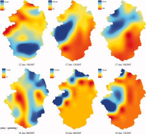
| • | On 12 January 18 GMT, a light rainy storm tracking east along the northern coast of Egypt and Eastern Mediterranean covering Cyprus, Israel, Lebanon, Syria and south Turkey. The rain differed along Egypt from 8 mm in Rosetta (Northern Nile Delta) and 4.5 mm in Suez ((a)). In Sinai Peninsula, the rain ranged between 0.5–5 mm ((a)).
Figure 5. Daily isohyetal maps of Egypt during 12, 17, 18 and 19 January 2010. 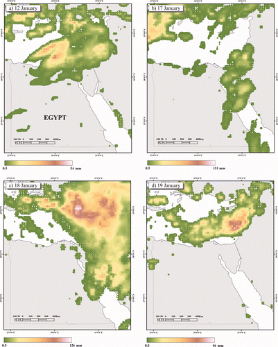
Figure 6. Averaged six hourly resolution isohyetal maps of Sinai Peninsula. 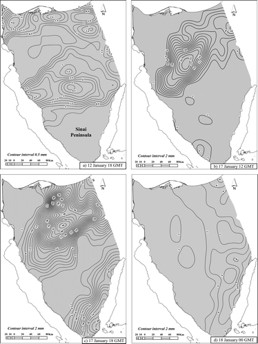 | ||||
| • | From 13 to 16 January, no rainfall was observed although the local weather was unstable. | ||||
| • | During 17 and 18 January 2010, Egypt was generally exposed to a deep low pressure at mid-troposphere characterized by counterclockwise strong wind drawn lots of equatorial moisture mixed with cold air aloft. | ||||
| • | Through the daytime, the maximum surface temperature in El Arish and Nekhil was considerably above the normal (18.7°C) owing to the advancing of the warm air at the lower levels accompanied by congested clouds. The mean surface temperature was higher as well than the mean daily temperature for January ().
Table 2. Surface air temperature during the flood events. | ||||
| • | On 17 January, the clouds were patchy distributed over the NW coast of Egypt, most of Sinai Peninsula, the Central Eastern Desert, Aswan and Halaib Triangle ((b)). At 12 GMT, the rain was concentrated over the west central and north eastern Sinai, varied greatly from 0.5 and 26 mm ((b)). The rain ranged over wadi El Arish between 1 mm at El Thamad and 13.7 mm in the upstream area of wadi El Bruck. | ||||
| • | At 18 GMT, the rain became much intensive, 30 mm in South Sinai and 50 mm in North and Central Sinai within a span of 6 hrs if not less ((c)). This was in accord with the gravity centre of the rain as shown from the six hourly hyetographs of wadi El Arish (). However, the rain was localized on the central and northern parts of the catchment (e.g. El Bruck 22.5 mm, Nekhil 22.1 mm, and El Arish 21.1 mm), while the southern parts received very few rains (e.g. El Thamad 1.1 mm).
Figure 7. Six-hour unit response hyetographs (in mm). 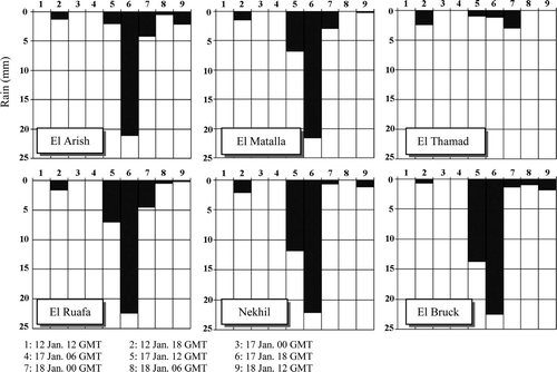 | ||||
| • | On 18 January, the low pressure moved ahead towards Israel, Lebanon and Jordan. The rain was aligned to the Central Eastern Desert of Egypt and Eastern Sinai Peninsula ((c)). It was insignificant anyway (0.5–2 mm) ((d)). | ||||
| • | Finally, the low pressure completely moved out of the Egyptian land on 19 January ((d)). | ||||
4.2 El Arish
| • | On 17 January 12 GMT, El Arish City was exposed to increasing north wind speed of 11 km/h at 1013 hPa sea level pressure. This was accompanied by scattered clouds and rain shower (2 mm). | ||||
| • | At 18 GMT, the NW wind dominated at low speed (5.6 km/h) accompanied by relative heavy rain (e.g. 21.1 mm) ().
Table 3. A six-hour rainfall (mm) in wadi El Arish. | ||||
| • | On 18 January 00 GMT, El Arish was subjected to relative high speed ESE winds of 35.2 km/h compared to the previous day, at low pressure of 1011 hPa. It was followed by thunder storm and light rain (4.22 mm). | ||||
| • | At 6 GMT, the southern wind blew at speeds of 9.3 km/h with shower thunder rain (0.5 mm). At 12 GMT, the pressure was considerably low as 1007 hPa and the WNW wind dominated at a relatively high speed of 14.8 km/h followed by light rain showers (2 mm). | ||||
4.3 Nekhil
| • | On 17 January 12 GMT, Nekhil was exposed to high speed SW wind of 22.2 km/h at relative low pressure (1012 hPa) accompanied by rainy thunder storm (11.8 mm). | ||||
| • | At 18 GMT, the cold north wind blew at a speed of 9.3 km/h and relatively high pressure level (1014 hPa). It was accompanied by heavy rain storm (22.1 mm) relative to the previous 6 hrs. | ||||
| • | On 18 January 00 GMT, the NNE wind blew at a speed of 11.1 km/h and 1013 hPa level followed by light shower rain (<1 mm). | ||||
| • | At 6 GMT, the north wind blew at a relatively high speed (13 km/h) and low pressure (1011 hPa). | ||||
| • | At 12 GMT, the western wind dominated at high speeds of 18.5 km/h and relatively low pressure level (1010 hPa) accompanied by light shower rain (1 mm). | ||||
5. Rain analysis
Cumulative rain and rain intensity are important parameters used to simulate the rainfall-runoff process and provide a forewarning about the possibility of a flood. Cumulative rain map was processed by adding the daily rainfall from 12 to 18 January 2010. shows that the total rain exceeded 73 mm over the central part of the wadi. Rain volume Vr for a given cell in the spatial model was estimated as:
Figure 8. Cumulative rain from 12 to 18 January 2010.
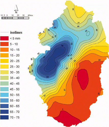
where RCum is the cumulative rainfall in mm, Cz is the cell size in m2 and Vr in cubic meter. Generally, the total rain volume Vr of wadi El Arish was 665.4 × 10⁶ m3. It varied between 5 × 10⁶ m3 for wadi Abu El Matamir and 191 × 106 m3 for wadi El Bruck.
Rain intensity ( I ) is the strength of the rainfall in millimetre per hour (mm/h) for the storm duration. For each six-hour storm rainfall amount ( P6 ), intensity was calculated using the following equation (Flood Control Section Citation2003):
where: P6 is the six-hour storm rainfall amount and D is the storm duration in minutes. It is obvious from that the majority of rain falls at very low intensity (<1 mm/h) owing to light rain. It is worth noticeable that such small amount of rain may have fallen during a shorter period than an hour, but the radar technology assembled the images only every 6 hrs. During 17 January, the intensity exceeded 4 and 8 mm per hour at 12 and 18 GMT respectively because of the relatively heavy rain. High rain intensities were localized mostly in the western and central water courses of the catchment during 17 January, rather than the southern water courses. This resulted in accumulation of large amount of water and contributed to more runoff from the central water courses.
Figure 9. Six-hour rain intensity.
6. Flow analysis
Overland flow water will only accumulate as an initial phase of surface runoff when rain intensity exceeds all losses. This relation was modelled using the empirical black box model. The model includes the hydrological parameters that influence the water runoff into a single regression relationship (Davie 2008). The simplicity of this type of model makes it widely applicable. The model was used to predict stream runoff from rainfall depending on the curve number CN approach developed by the United States Department of Agriculture, Soil Conservation Service (SCS 1985). It is commonly used in the United States in areas lacking good coverage by rain gauges and in areas having poor runoff records, a situation like that encountered in the study area. It is also suited for humid, semi-arid, and arid conditions and has been successfully applied to ephemeral watersheds in southwestern United States (SCS 1986). Surface runoff Q was estimated using the reduced equation as follows:
Where Q is the surface runoff (mm); P is the storm precipitation total (mm), this was compensated by the cumulative rainfall RCum ; and S is the potential retention parameter or surface storage after runoff begins (mm) that is a function of an empirical curve number CN coefficient where:
where CN is a coefficient that reduces the total precipitation to runoff potential after losses (i.e. evaporation, absorption, transpiration, surface storage). The higher the CN value, the higher the runoff potential. It is determined by many factors, such as the antecedent runoff condition (ARC), hydrological soil group (HSG), hydrologic condition and land cover/use. CN was derived from the published lookup tables by the SCS (Citation1986). The ARC is a function of the total rainfall in the five-day period preceding a storm. This was substituted by the rain event on 12 January 2010. As the rain was very low (0.5–5 mm), the ARC was assumed to be low (ARC I = dry condition). Hydrologic conditions (cover type) were classified from the ETM+ mosaic as natural desert landscape and desert shrub (poor coverage, less than 30% ground cover).
Investigation of the Soil Map of Egypt (1:2.000.000) revealed that the wadi floor is made up predominately of yellowish brown Xericfluvents and Torrifluvents deposits dominated by sand, clay and gravel. The soil is primarily derived from the limestone and to a lesser degree sand. The calcium carbonate content CaCO3 ranges between 1.22 and 26.5%. In the lower watercourse of wadi El Arish, the water contents range from 0.7 to 0.13 cm3 water/cm3 soil. Hydraulic conductivity reveals moderate to slow water movement as the soil permeability ranges from 0.44 to 14.64 cm h−1 (Hassan Citation2002). In the upstream area, the wadi bottom is covered with consolidated deposits (e.g. gravel, clay and sands). Soil of the overland flow is mainly Lithosols and Calciorthids (calcic accumulation >15%) (Greenwood Citation1997). The surface is dominated by bare dissected bedrock that looks like armoured-surface as it is covered by shallow regolith (flint, dark gravelly sands and sand sheets) derived mainly from limestone. The ETM+ mosaic and the Soil Map of Egypt (1:2.000.000) were used to adapt the soil classes according to the hydrological soil group HSG and to simply identify their curve number CN . Therefore, three soil groups were identified as follows:
| • | Group A: sand dunes, sand sheet and sand loamy soils that are relatively deep, well drained with low runoff potential and high rate of water transmission (>7.62 mm/h). | ||||
| • | Group B: wadi fillings that have moderate infiltration rates. It consists of moderately well to well drained soils with moderately fine to moderately coarse textures with a moderate rate of water transmission (3.81–7.62 mm/h). A top-crust (15–35 cm thick) of fine materials was observed in many locations along the wadi floor. It is believed that such stable surface layers significantly reduce infiltration and permeability over time and lead to runoff (Lange and Leibundgut 2005). This relation was not fully tested in the field and it was difficult to be applied within the model unfortunately. | ||||
| • | The nearly impervious surfaces: Surfaces that have high runoff potential. They consist of the consolidated alluvial deposits and the massif and dissected limestone covered by shallow loose materials. Such surfaces have relative low infiltration rates (0–1.27 mm/h). | ||||
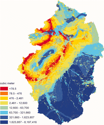
Where CN I is the curve number for dry condition (ARC I) and CN II is the curve number for normal condition (ARC II). Accordingly, the CN I values were 42, 58, and 95 for the hydrological groups A, B and the nearly impervious surfaces, respectively. Then, CNI values were weighted in proportion to the cell size to compute the composite curve number for each sub-basin. It could also be carried directly by weighting the CNI values for a given basin area. Then, the CNI and RCum grids were converted to polygon shapes based on the curve number and rain values, respectively. The layers were intersected by joining all attributes. Database of the intersected new layer contains several parameters, e.g. poly_area m2, HSG, CNI, S, 0_2S, and RCum. Eventually, the total surface runoff Q of wadi El Arish was estimated as 123.3 × 103 mm. It varied from 0.2 × 103 mm for wadi Abu El Matamir and 45.9 × 103 mm for wadi El Ruaq. Moreover, runoff volume Vq for a given cell was estimated as:
where Q is obtained from equation (3) in mm, Cz is the cell size is in units of ground distance (m2) and Vq in cubic meters (). Accordingly, the total runoff volume of wadi El Arish was estimated as 124 × 106 m3 (), which constituted about 18.8% of the total rain volume Vr . The runoff volume ranged between 1.77 × 10⁶ m3for wadi El Azariq and 50 × 106 m3 for wadi El Ruaq. However, the total surface losses were estimated as 541.4 × 10⁶ m3, which reveal the effect of CN coefficients in reducing the potential runoff.
Table 4. Flow estimations.
Figure 10. Runoff volume.
On 18 January, the flowing water reached El Arish City at 16:30 GMT (at 6:30 PM local time). The time elapsed since the beginning of the strengthened rainstorms on 17 January 2010 at 12 and 18 GMT and the arrival time of flow to El Arish City on 18 January was 28:30 and 22:30 h, respectively. These affirm that the central part of the basin was responsible for most of the flow (∼229–183.7 km south from the pour point). The average flow velocity of the water at the dam was 1.6 m/s. It was assumed that the flow velocity was constant along the last 50 km of the wadi channel until its pour point. Therefore, the water has exceeded the dam, most likely, on 18 January at 7:49 GMT (9:49 AM local time) once the lake had stored some 5.5 × 10⁶ m3 of water. The average height of the water was 10 cm over the dam and 45 cm over the wadi floor near El Arish City.
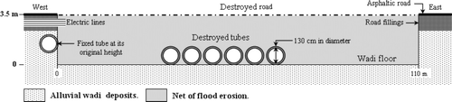
On 19 January, the height of the water considerably increased to ±50 cm over the dam. In El Arish City, the water accumulated at Ezbet Maliem behind the major road for ±4 m high. It inundated the surrounding areas such as villages of Atif, Abu Thaqal and Al Badawi to some 2 m high. Therefore, the flowing water completely destroyed the main road connecting the eastern and western sides of El Arish City (), and hampered the relief operations for many hours. On the other hand, the water flooded vast areas of the northern lowlands because the outlet of the wadi was blocked by the Olympic centre. This required extraordinary efforts to enable the water reaching the sea. The flow terminated at 08 GMT (10 AM local time) on 19 January.
Figure 11. Cross section of wadi El Arish showing the destruction of a major cross road and culverts that led to hamper relief operations between the eastern and western sides of the city.
7. Discussion and results
The short-term violent flood event of wadi El Arish on 18 January 2010 has highlighted the urgent need for better flood protection plan besides raising the public awareness and regular maintenance. Such protection plan requires accurate hydro-meteorological data that are not available owing to poor rain gauge covering and absence of runoff measurements. Therefore, the present study based primarily on the integration of remote sensing and GIS to monitor the general development of the storm rain and to estimate the surface runoff using the empirical curve number method.
Analysis of the TRMM images and the averaged six hour HYDIS data from 12 to 19 January 2010 revealed that the gravity centre of the storm occurred on 17 January at 18 GMT where the rain intensity varied between 4 and 8 mm/h. The total rain volume was 665.4 × 10⁶ m3. However, cubic convolution processing was applied to ASTER DEMs and the hydrological model was constructed at a threshold value ≥150 cells. The wadi attained the 9th order and 10 sub-basins were defined for better application of curve number method. This method includes several important properties of the watershed namely, soil permeability, land use and antecedent runoff conditions (ARC) which were taken into consideration. Landcover and hydrological soil groups (HSG) were identified from the Landsat ETM+ mosaic using multispectral supervised classification. The HSG of the wadi was classified into: Group A: sand dunes of low runoff potential and high rate of water transmission, Group B: wadi fillings that have moderate infiltration rate and finally, surfaces of high runoff potential. The fitted curve numbers CN of the soil groups were adjusted to the ARC I (dry condition) as 42, 58, and 95 in the same order as the soil groups. As a result, the estimated total surface runoff Q was 123.3 × 103 mm; the total volume runoff Vq was 124 × 106 m3 that constitutes 18.8% of the total rain volume and the total surface losses were estimated as 541.4 × 10⁶ m3.
Since there were no runoff measurements available from wadi El Arish, the results based on the curve number method could not be calibrated in comparison with real measured values. However, it is suited for humid, semi-arid and arid conditions (SCS 1985; (a)–(d)). It has been widely applied to several wadis in the Eastern Desert of Egypt and Sinai by Gheith and Sultan (Citation2001–2002), Foody et al. (Citation2004), Moawad (Citation2008), Sherief (Citation2008) and Moawad and Khidr (Citation2011). In comparison with other literature, the estimated total runoff volume is in the agreement with the measured runoff during the flood event on 19 February 1975 that was 120 × 106 m3 (Klein Citation2000). The estimated surface losses are in accordance with the results obtained by Klein (Citation2000) as 680 × 106 m3 and the estimated annual average losses by Gheith and Sultan (Citation2001) in wadi El Arish as 938.7 × 10⁶ m3. Therefore, it is expected that the data obtained from this work might be helpful for a better action plan and the approach could be widely applied to other watersheds in the region.
Acknowledgements
The author would like to acknowledge the anonymous reviewers for their valuable comments and suggestions to improve the manuscript. Special thanks go to Nabil S. Embabi, Professor of physical geography at Ain Shams University, who assisted with many suggestions and corrections.
References
- Abd-El Monsef , H. 1991 . “ Geological and hydrogeological study in wadi El-Arish Basin using LANDSAT images ” . Ismailia , Egypt : Suez Canal University . MSc thesis. Faculty of Sciences
- Botrous , K. G. 1960 . “ Water resources in Sinai Peninsula ” . In Encyclopedia of Sinai (in Arabic) , Edited by: Supreme Council of Sciences . 214 – 227 . Cairo : Al Amiria Press .
- Chow , V. T. , Maidment , D. K. and Mays , L. W. 2002 . Applied Hydrology , New York : McGraw-Hill Book Company .
- Colombo , G. , Hervás , J. and Arellano , A. L. 2002 . Guidelines on Flash Flood Prevention and Mitigation , Italy : EUR 20386 EN Alessandro .
- Dames and Moore International . 1985 . Sinai Data Book: Sinai Development Study. Phase I, Final report , Volume VII , Cairo : the Advisory Committee for Reconstruction Ministry of Development .
- El-Bihery , M. A. and Lachmar , E. 1994 . Groundwater quality degradation as a result of overpumping in the delta wadi EI-Arish area, Sinai Peninsula, Egypt . Environmental Geology , 24 : 293 – 305 . doi: 10.1007/BF00767091
- El Husseini , S. S. 1987 . Water resources in Sinai Peninsula (in Arabic) . Bulletin of the Society of Geography Kuwait , 100 : 99
- Flood Control Section . 2003 . San Diego County Hydrology Manual , 322 San Diego : San Diego County Flood Control Advisory Commission .
- Foody , G. M. , Ghoneim , E. M. and Arnell , N. W. 2004 . Predicting locations sensitive to flash flooding in an arid environment . Journal of Hydrology , 292 : 48 – 58 . doi: 10.1016/j.jhydrol.2003.12.045
- Gheith , H. M. and Sultan , M. I. Assessment of the renewable groundwater resources of wadi El-Arish, Sinai, Egypt: Modelling, remote sensing and GIS applications . Proceedings of a Symposium Held at Santa Fe . April 2000 . New Mexico : IAHS Publ. no. 267 .
- Gheith , H. M. and Sultan , M. I. 2002 . Construction of a hydrologic model for estimating wadi runoff and groundwater recharge in the Eastern Desert, Egypt . Journal of Hydrology , 263 : 36 – 55 . doi: 10.1016/S0022-1694(02)00027-6
- Greenwood , N. H. 1997 . The Sinai: A Physical Geography , 148 Texas : University of Texas Press .
- Hamdan , G. 1980 . The Personality of Egypt (in Arabic) , Vol. 1 , 841 Cairo : Aalam El-Kotob .
- Hassan , M. A.A. 2002 . “ Environmental Studies on Coastal Zone Soils of the North Sinai Peninsula (Egypt) Using Remote Sensing Techniques ” . 247S Braunschweig : Bundesforschungsanstalt für Landwirtschaft . Landbauforschung Völkenrode Sonderheft 238
- Khidr , M. M. 1997 . “ The main geomorphological hazards in Egypt (in Arabic) ” . 513 Cairo : Ain Shams University . MSc thesis. Department of Geography, Faculty of Arts
- Klein , M. The formation and disappearance of a delta at the El-Arish river mouth . Proceedings of the Jerusalem Conference . May 1999 , Jerusalem . pp. 303 – 310 . Jerusalem : IAHS Publ., no. 261 .
- Lange , J. and Leibundgut , C. 2005 . “ Surface runoff and sediment dynamics in arid and semi-arid regions ” . In Understanding Water in a Dry Environment: Hydrological Processes in Arid and Semi-arid Zones , Edited by: Simmers , I. 115 – 150 . The Netherlands : Swets & Zeitlinger B.V .
- Lillesand , T. M. and Kiefer , R. W. 2000 . Remote Sensing and Image Interpretation. , 4th ed., , 724 New York : John Wiley & Sons .
- Martinez-Casasnovas , J. A. and Stuiver , H. J. 1998 . Automatic delineation of drainage networks and elementary catchments from digital elevation models . ITC Journal , 3/4 : 198 – 208 .
- Moawad , B. M. 2008 . Applications of Remote Sensing and Geographic Information Systems in Geomorphological Studies: Safaga-El Quseir area, Red Sea, Egypt as an Example , 282 Saarbrücken : VDM Verlag Dr. Müller .
- Moawad , B. M. and Khidr , M. M. 2011 . A GIS and RS based approach for modeling ungauged small-scale catchments in Mersa Alam . Bull. Soc. Gèogr. Ègypte , 84 : 117 – 140 .
- Scs (US SOIL CONSERVATION SERVICE) . 1985 . National Engineering Handbook , Washington DC : US Government Printing Office . US Department of Agriculture
- Scs (US SOIL CONSERVATION SERVICE) . 1986 . Urban Hydrology for Small Watersheds , Springfield , VA : USDA . Technical Report 55
- Sherief , Y. SH. 2008 . “ Flash floods and their effects on the development in El-Qaa plain area, South Sinai, Egypt ” . 284 Germany : der Johannes Gutenberg- Universität Mainz . PhD thesis, am Fachbereich Chemie, Pharmazie, Geowissenschaften
- Smith , K. and Petley , D. N. 2009 . Assessing Risk and Reducing Disaster. , 5th ed. , 383 New York : Routledge .
- Soenario , I. and Sluiter , R. 2010 . Optimization of Rainfall Interpolation , 31 Nederlands : Koninklijk Nederlands Meteorologisch Instituut . Version 2.0
- Sorooshian , S. K. , Hsu , L. , Imam , B. and Hong , Y. 2008 . “ Global precipitation estimation from satellite image using artificial neural networks ” . In Hydrological Modelling in Arid and Semi-Arid Areas , Edited by: Wheater , H. , Sorooshian , S. and Sharma , K. D. 21 – 27 . Cambridge : Cambridge University Press .
- Strahler , A. N. 1957 . Quantitative analysis of watershed geomorphology . American Geophysics Union Transactions , 38 : 913 – 920 . doi: 10.1029/TR038i006p00913
- Tarboton , D. G. , Bras , R. L. and Rodriguez-Iturbe , I. 1991 . On the extraction of channel networks from digital elevation data . Hydrological Processes , 5 : 81 – 100 . doi: 10.1002/hyp.3360050107
- Unep . 1997 . World Atlas of Desertification. , 2nd ed. , London : UNEP .
- Walter, H. and Lieth, H. 1967 . Klimadiagramm-Weltatlas , Jena, Germany : VEB Gustav Fischer Verlag .