
Abstract
Turkey is a country that has active fault lines and is prone to earthquake. The positional variations resulted from the Van earthquake (a magnitude of M = 7.2) on 23 October 2011 and were calculated by using data from CORS-TR (Continuously Operating Reference Station network) stations. The GPS data from the CORS-TR stations effected from the earthquake were evaluated by the BERNESE 5.0 software. For calculating the positional displacements in the CORS-TR stations after the earthquake that occurred in Van, the measurements from 16 International GNSS Service (IGS) stations around Turkey, where their coordinates and velocity vectors were considered to be constant at the ITRF2005 datum. The greatest variation was measured from the Muradiye station, which is the closest point to the epicentre of the earthquake. The variation in this station was −42.7 mm in the vertical direction, −60.3 mm in the northern direction and −18.7 mm in the eastern direction.
1. Introduction
Determining the amount of variation at the point coordinates through the Global Satellite Navigation Positioning System (GNSS) network requires continuous observation to study the variations related to earthquake and tectonic displacements. Measuring the amount of displacement created by earthquakes is very important from the point of view in preventing great disasters in Turkey, where earthquake and the tectonic activities are intense.
The positional displacements pertaining to the Van earthquake that occurred in Turkey have been studied in this research (figure ). In order to measure the tectonic displacements, and the positional displacements happened after the earthquake, the position data of the CORS-TR stations placed around the earthquake region were obtained for the day before, on the day and the day after the earthquake from the International GNSS Service (IGS) stations and were evaluated by using BERNESE 5.0 academic software.
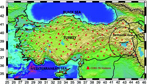
Figure 1. Van earthquake region.
2. CORS-TR System
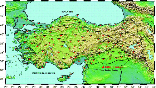
CORS-TR System is a network that comprises 146 stations in total, scattered in such a way that to cover Turkey and the North Cyprus Turkish Republic. The main control centre of the system has been set up in Ankara. The CORS-TR System became active in 2009 and maintains its activities in an uninterrupted manner. The system collects data from all of the stations at one-second intervals for 24 hours. The distribution of the CORS-TR stations is shown in figure . The layout of the stations was established by using the stations providing best data to observe the tectonic-plate displacements (Mekik et al. Citation2011; Uzel et al. Citation2011).
Figure 2. Distribution and fault lines of the CORS-TR stations.
3. Tectonic structure of the Van region
Turkey is an actively deforming region and subject to devastating earthquakes for long time. The earthquakes in Turkey are governed by three major geological structures: the Aegean-Cyprean Arc, the dextral North Anatolian Fault Zone and sinistral East Anatolian Fault Zone (Bozkurt Citation2001). These structures were originated from westward escape of Anatolian plate squeezed between two colliding plates, the Arabian and Eurasian plates. The abovementioned two fault zones meet and form a continental triple junction to the east of Karlıova in eastern Turkey (Bozkurt Citation2001). The area located at the east of the Karlıova triple junction is represented by N-S compressional tectonic regime in which there are several faults parallel to the North and East Anatolian fault zones (figure ). These faults are seismically active and cause many earthquakes in the regions. Of these, the Ercis, Caldıran, Hasantimur Lake, Suphan and Malazgirt fault lines are the active faults in the region where the Van earthquake on 23 October 2011 occurred.
Figure 3. Distribution of the IGS stations used as reference.
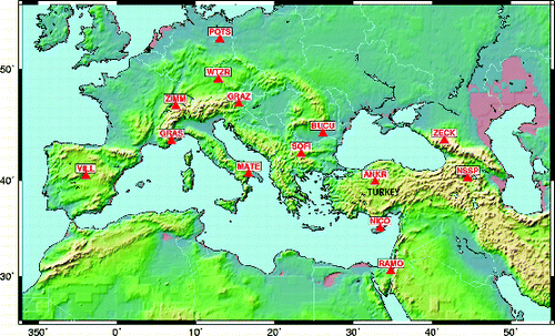
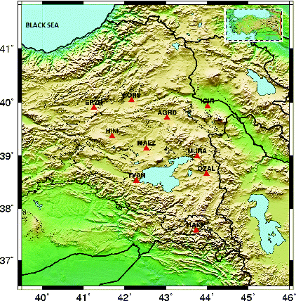
Figure 4. CORS-TR stations affected by the Van earthquake.
4. Point-position calculations
To study the positional displacements in the CORS-TR stations for the earthquake that occurred in Van, we obtained data from 16 IGS stations around Turkey, where their coordinates and velocity vectors were considered as invariable at the ITRF2005 datum (figure ).
The GPS data from the CORS-TR stations experiencing the earthquake were evaluated with BERNESE 5.0 software (Dach et al. Citation2011). In order to define the coordinates of CORS-TR stations where the GPS measurements have done in the ITRF system, measurements from 16 IGS (International GPS Service) stations having appropriate position in Europe and Asia were included in calculation.
The Bernese 5.0 software used in evaluation of GPS observations carried out in CORS-TR stations where earthquake occurred was realized in two steps.
In the first step: The CORS-TR stations coordinates have been calculated approximately in centimetres accuracy by applying PPP (Precise Point Positioning) method. During this stage, code and phase measurements obtained from CORS-TR stations and receiver-satellite clock errors (IGSwwwd.CLK) measured by IGS in 5-minute intervals were used. At the adjustment stage, the coordinates of each point have been calculated separately without having any network structure. Until the first network solution during the parameter estimation stage, the calculated coordinates have been taken as a priori for the evaluation of double difference measurements as being the second stage.
In the second step: Double difference measurements were evaluated. At this step, the IGS points at the date of measurements have also been added into the evaluation. The criteria used in the evaluation of double difference measurements have been given in ) and ).
5. Van earthquake findings
An earthquake with a magnitude of M = 7.2 took place on 23 October 2011 at 01:41 pm local time in the Van region, Turkey. The epicentre of the earthquake was close to the northern part of central Van province (figure ). The earthquake was felt in a wide area in East Anatolia including: Diyarbakır, Batman, Sırnak, Mus, Erzurum, Bingol, Bitlis, Siirt, Ağrı and Iğdır. The coordinates of the external epicentre of the earthquake were 38.7578 N–43.3602 E, in accordance with the records of the Kandilli Observatory (Van Earthquake Citation2011).
The data obtained from the CORS-TR stations (Ağrı, Baskale, Erzurum, Muradiye, Ozalp, Tatvan, Hakkari, Hınıs, Horasan, Iğdır and Malazgirt) in the Van region where the earthquake occurred between 13 and 29 October 2011, together with the positional variations, were examined (figure ).
After examining the positional data measured before and after earthquake, positional displacements were observed in all stations included in evaluation. The Root Mean Square (RMS) values obtained from the CORS-TR station coordinates are given in .
Table 1(a). Evaluation strategy of GPS measurements with the Bernese 5.0 software (model).
Table 1(b). Evaluation strategy of GPS measurements with the Bernese 5.0 software (parameters).
Table 2. The RMS values of CORS-TR station coordinates.
In statistical theory, precision is measured by the standard deviation (also called standard error or root mean square – RMS). Theoretically
(1) where RMS is the standard deviation of a very large sample, v is the true residual and n is the large sample size (Kavanagh & Bird Citation2000).
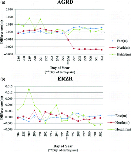
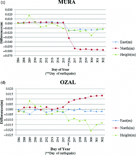
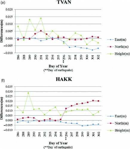
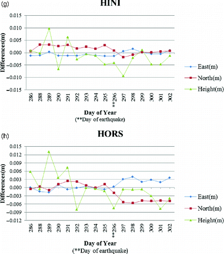
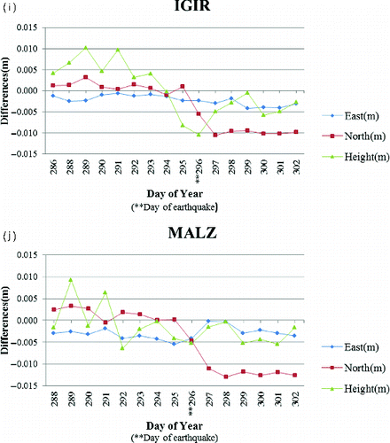
The greatest displacement was calculated as ΔNorth = 0.0286 m (figure (a)) in the N-S line and in the South direction for Ağrı (AGRD); as ΔElevation = 0.0176 m (figure (b)) for Erzurum (ERZR); as ΔNorth = 0.0603 m in the N-S line and in the South direction (figure (c)) for Muradiye (MURA); as ΔNorth = 0.0150 m and ΔElevation = 0.0291 m in the N-S line and in the North direction (figure (d)) for Özalp (OZAL); as ΔEast = 0.0085 m and ΔElevation = 0.0181 m, especially in the E-W line, West direction (figure (e)) for Tatvan (TVAN) where the displacements and the elevations before the earthquake were observed on a separate basis; as ΔEast = 0.021 m in the N-S line and in the North direction, contrary to the expectations (figure (f)) for Hakkari (HAKK) where activity in the elevation and displacement before the earthquake was observed on a separate basis; as ΔElevation = 0.0191 m (figure (g)) for Hınıs (HINI); as ΔElevation = 0.0208 m (figure (h)) for Horasan (HORA); as ΔElevation = 0.0207 m and ΔNorth = 0.0138 m in the N-S line and in the South direction (figure (i)) for Iğdır (IGIR); as ΔElevation = 0.0148 m and ΔNorth = 0.163 m in the N-S line in the South direction (figure (j)) for Malazgirt (MALZ).
Figure 5. (a) Ağrı CORS-TR station – the magnitude of displacement. (b) Erzurum CORS-TR station – the magnitude of displacement. (c) Muradiye CORS-TR station – the magnitude of displacement. (d) Özalp CORS-TR station – the magnitude of displacement. (e) Tatvan CORS-TR station – the magnitude of displacement. (f) Hakkari CORS-TR station – the magnitude of displacement. (g) Hınıs CORS-TR station – the magnitude of displacement. (h) Horasan CORS-TR station – the magnitude of displacement. (i) Iğdır CORS-TR station – the magnitude of displacement. (j) Malazgirt CORS-TR station – the magnitude of displacement.
6. Results and conclusion
Earthquakes like the one in the Van region in 2011 show that much more measurements are inevitable for the prevention and prediction of future earthquakes in countries such as Turkey, where activities on fault lines are intensive.
All countries have already established their CORS networks. The establishment of the Turkish CORS-TR network started in 2006 and was completed in 2009. It is one of the greatest networks in the world to date. The CORS-TR network can be used both for the real-time applications and also for post-process bureau calculations. One of the main purposes of the network is to focus on tectonics, like determining the plate displacements and forecasting the earthquakes. The CORS-TR network has, therefore, been designed by taking the tectonic structure of Turkey into account.
The magnitude of displacements resulted from the Van earthquake on 23 October 2011 was evaluated by using data from CORS-TR points in Ağrı, Ezurum, Muradiye, Özalp, Tatvan, Hakkari, Hınıs, Horasan, Malazgirt and Iğdır provinces. The data from these stations comprise measurements one week before and the day after earthquake. They were evaluated by taking into account the parameters given in ) and ) and by using the data at the IGS points given in figure with BERNESE 5.0 software. The maximum displacements for each CORS-TR stations were calculated and shown in figures . The greatest variation was measured from the Muradiye station, which is the closest point to the epicentre of the earthquake. The variation in this station was –42.7 mm in the vertical direction, –60.3 mm in the northern direction and −18.7 mm in the eastern direction.
Figure 6. Maximum changes in positions determined as a result of the earthquake.
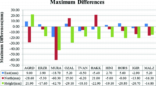
Figure 7. North-East components maximum displacement vectors.
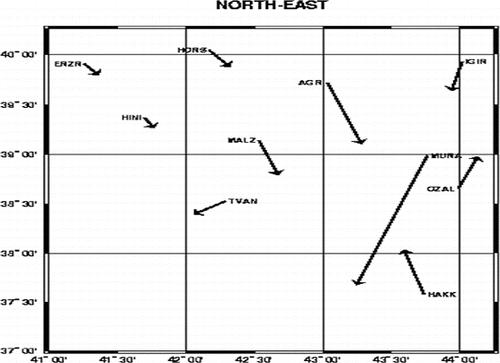
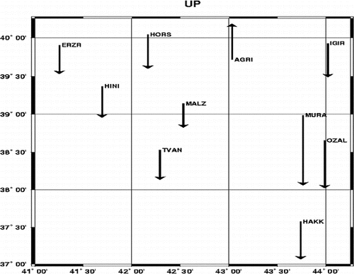
Figure 8. Elevation component maximum displacement vectors.
Acknowledgement
The authors would like to thank the editor and two anonymous reviewers for their valuable comments and suggestions to improve the manuscript. The authors also thank CORS-TR Center for providing data and Prof. Dr. Hükmü ORHAN for his valuable comments and suggestions. Figures were plotted using the terrific software of Wessel and Smith (Citation1995).
References
- Bozkurt E. 2001. Neotectonics of Turkey-a synthesis. Geodinamica Acta. 14:3–30.
- Dach R, Hugentobler U, Walser P. 2011. Bernese GPS Software (Version 5.0). Bern, Switzerland: Astronomical Institute, University of Bern.
- Kavanagh BF, Bird SJ. 2000. Surveying: Principles and applications. 5th ed. Upper Saddle River (NJ): Prentice Hall.
- Mekik C, Yildirim O, Bakici S. 2011. The Turkish real time kinematic GPS network (TUSAGA-Active) infrastructure. Sci Res Essays. 6(19):3986–3999.
- Uzel T, Eren K, Gulal E, Dindar A, Tiryakioglu I, Yilmaz H. 2011. Tectonic plate displacement monitoring with TUSAGA - Active (CORS-TR) data. Paper presented at: 13th Turkey Map Scientific and Technical Conference; Ankara, Turkey (In Turkish).
- Van earthquake. 2011. 23 October 2011 Van Earthquake. [cited 2012 Apr 6]. Available from: http://www.mta.gov.tr/v2.0/deprem/2011_Van-Depremi_On-Degerlendirmeler.pdf
- Wessel P, Smith WHF. 1995. New version of the generic mapping tools released, EOS. Trans AGU. 76:329.