
Abstract
Underground structural deformation occurs because of the complex effects of the internal and external environments and it needs to undergo regional coverage deformation monitoring to realize the early warning of natural hazards. This issue remains a challenge for current deformation monitoring techniques. We present a geographic mapping model based on an ultrasonic omnidirectional array for deformation monitoring. First, an ultrasonic spherical array is established to achieve all-around monitoring for underground structural deformation. Second, an earth longitude–latitude mapping method is adopted to visually manage the spatial monitoring information. Third, the initial working time for the sensor node is allocated by considering a variety of environmental factors and using an intelligent clustering algorithm. The proposed method automatically detects, localizes, and tracks deformations by analysing the monitoring information, which is displayed on the earth longitude–latitude map. Lastly, experimental data are used to illustrate the application techniques as well as demonstrate the validity of the approach.
1. Introduction
Nowadays, geographic information systems (GIS) play an important role in mining data management and decision-making in mines (Popiolek & Hejmanowski Citation2008). Most applications related to deformation monitoring use GIS technology to study the influence of underground exploitation over the surface on highlighting the movement phenomenon (Malinowska & Hejmanowski Citation2010; Dragomir & Herbei Citation2012; Ghosh & Chakravarty Citation2012). The obtained surface deformation map is integrated with digitized mine production maps and with QuickBird orthographic images into the GIS to analyse subsidence effects (Akcin et al. Citation2010). Underground structural deformation monitoring that adopts GIS technology has not been examined well.
In contrast to the ground-level space development, underground space development involves key problems that need to be resolved. For instance, deformation of the tunnel profile is an important symptom of the response of the tunnel subjected to changes in the stresses in the surrounding rock mass (Wang et al. Citation2010). Actually, structural deformation occurs because of the complex effects of the internal and external environments, which can directly reveal the structural safety when monitored online (Bhalla et al. Citation2005). Underground structures are surrounded by geotechnical pressure from every direction and need to undergo regional coverage deformation monitoring. This issue remains a challenge for current deformation monitoring techniques.
The current study presents a geographic mapping model based on ultrasonic omnidirectional array for monitoring structural deformation. An ultrasonic spherical array is established for the all-around monitoring of underground structural deformation. An earth longitude and latitude mapping method is adopted for the visual management of the spatial monitoring information. The proposed method automatically detects, localizes, and tracks structural deformation after considering the complex environmental factors during the system initialization stage.
2. Underground structural deformation monitoring techniques
For the special features of underground structures, many scholars have examined a number of deformation measurement methods. These methods can be categorized into contact and non-contact measurement methods, in accordance with the relative position of the measurement device and the measurement object. The contact measurement method involves the installation of sensors on the structural surface or within it. For example, the electrolevels are mounted on a ring of interconnected beams in a London underground tunnel that requires deformation monitoring during construction (Bassett et al. Citation1999). The BOTDR (Brillouin optical time domain reflectometer)-based distributed fibre optic strain sensing system is used to detect the deformation in a tunnel in the underground mine ventilation level (Naruse et al. Citation2007). The microelectromechanical system (MEMS) strain sensors are used to realize a novel type of crackmeter for health monitoring of ageing civil infrastructures (Ferri et al. Citation2010). The advantage of these methods is that they can acquire the exact location of the measurement point. However, these methods only provide discrete point measurements rather than giving a continuous record of the damage dimension in the whole affected area (Armesto et al. Citation2008). In addition, these methods are inconvenient to conduct and maintain, so they are only applied to key areas underground.
The non-contact measurement method is used when a certain distance exists between the measurement sensors and the structure. Information on structural deformation is acquired via monitoring of the changes in space geometry between the measurement sensors and the structure. To enable a fast and precise measurement of the tunnel profile, a method, the so-called profile image method, has been proposed (Wang et al. Citation2009). In addition, continuous scan image technology (Ukai et al. Citation1996), automatic tracking total station (Walker et al. Citation2006), and three-dimensional (3D) laser imaging scan technology (Fekete et al. Citation2010) are used to achieve real-time deformation monitoring of a key area of a tunnel. Non-contact measurement methods, which are characterized by easy installation and are mobile, overcome some of the shortcomings of contact measurement methods. However, the primary shortcoming of image-based structural behaviour monitoring techniques is the light requirement that precludes the measurement at night (Park et al. Citation2007). In addition, it is indicated that in long tunnels the precision of the measurements is often reduced by dust or fuel emissions, while the accuracy is reduced in case of multiple positions of the instrument (Michael Citation2005).
The above-mentioned methods achieve measurement of regional expansion through distributed sensor networking or mobile scanning. A number of measurement points with blind spots between them determine the scope of the monitoring area. Therefore, if deformation occurs at the blind spot, the monitoring network will have no reflection data until the deformation spreads to the monitoring points. Consequently, the demand for high-coverage regional monitoring requires urgent effective solutions.
Ultrasound is an acoustic wave with a frequency above 20 KHz. Its characteristics include concentration direction, spread in different media, and insensitivity to colour, light, and electromagnetism. Therefore, it can be used in adverse environments with darkness, dust, smoke, and strong electromagnetic interference. In the field of structural safety monitoring, current studies for ultrasound technology have focused mainly on the internal crack detection of structures (Lyer et al. Citation2005; Baillie et al. Citation2009). The design and application of ultrasonic wave reflection imaging are also documented in the study for the detection of the discontinuity planes or cavities in laboratory-scale rock models (Lee et al. Citation2009). Comparatively, ultrasound technology for structural surface deformation monitoring has not been examined well.
An ultrasonic beam can cover a wide area due to its divergence. In the current study, this feature is used to increase the coverage of the monitoring area. The structural surface deformation will cause displacement, resulting in a change in the length of ultrasonic transmission. The distance-measuring principle of the ultrasonic wave is used to acquire information on the structural surface deformation. Thus, the deformation parameters acquired in this study are vector displacements.
Measuring the distance via ultrasound involves a transducer emitting ultrasonic wave; an obstacle reflects the wave afterward. A receiver then detects the echoes of the ultrasonic wave soon after. Using the differential transmission and reflection of ultrasonic waves combined with their velocity, the distance can be calculated.
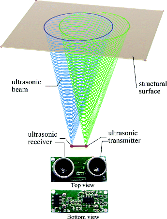
The 3D space model for one ultrasonic beam is shown in . The ultrasonic transceiver adopted in the present work contains a transmitter and a receiver ().
Figure 1. Three-dimensional space model for one ultrasonic beam.
With an existing beam angle, the ultrasonic transmitting area is an enclosed cone profile area. The available ultrasonic echo-receiving area is also an enclosed cone profile area. Some transmitting areas overlap the echo-receiving area, and they form a projection area, which is a closed region on the structural surface. The points within the region can be monitored, leading to the discovery of a way to attain high-coverage regional monitoring for structural surface deformation.
3. Geographic mapping model
3.1. Ultrasonic omnidirectional array
This study established an ultrasonic spherical array for omnidirectional space detection. The centre of the sphere was considered the origin and the ultrasonic transceiver arrays are localized on the surface of the sphere. A spatial 3D coordinate system was established as shown in .
Figure 2. Spatial three-dimensional coordinate system of omnidirectional ultrasonic array.
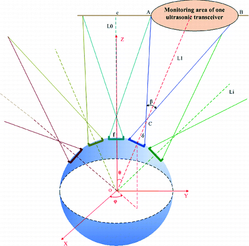
The spatial curve of the monitoring area is calculated using geometry. The spatial curve of the monitoring area of the ultrasonic transceiver in was acquired as follows: (1) Solving the equation of the sensor projection plane; (2) solving the equation of the ACB cone; and (3) combining these two equations to derive the spatial curve equation.
The ultrasonic spherical array is used as a spatial measurement benchmark to detect the random structural deformation in underground space.
3.2. Geographic latitude and longitude mapping
This study proposes the novel idea of using the geographic latitude and longitude mechanism to lay out the sensors. The latitude and longitude lines are first designed on the surface of a sphere. Then, the sensors are installed on the intersections of the latitude and longitude lines. illustrates the layout of the ultrasonic array with an interval phase of 30° for longitude and 15° for latitude.
Figure 3. Geographic latitude and longitude layout of ultrasonic omnidirectional array.
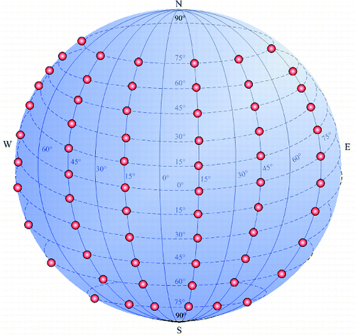
Based on the layout mechanism above, the 3D space monitored with the ultrasonic array is orderly divided into a series of subspaces. These subspaces are distinguished from each other by identifying the ultrasonic sensors localized on the different latitude and longitude lines. The monitoring information for each direction in the 3D space is mapped into a latitude and longitude map to allow the visual management of spatial monitoring information, as shown in , which presents the structure of the data (monitoring data, as well as latitude and longitude coordinates). The monitoring data indicate the monitoring deformation state, whereas the latitude and longitude coordinates are divided into east longitude, west longitude, south latitude, and north latitude.
Figure 4. Longitude–latitude map of the monitoring space.
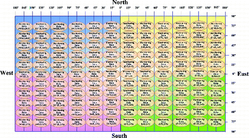
visualizes the deformation monitoring space in terms of the latitude and longitude plan. The monitoring data are space-ranging data that correspond to a certain subspace. The location of the monitoring space and the size of the monitoring area are determined by calculating the spatial coordinate information of the ultrasonic sensor.
3.3. Numbering the ultrasonic sensor node
The latitude is set at B and the longitude is set at L. The sign of the north latitude B is ‘+’, the south latitude B is ‘−’, the east longitude L is ‘+’, and the west longitude L is ‘−’. The interval phase of the longitude is L0 and the interval phase of the latitude is B0. We designate (Ln,Bn) as the longitude and latitude coordinates of the sensor nodes, respectively. Also, (p,q) is the designation of the sensor nodes, which is calculated as follows:(1) where p and q are usually assigned as integers to facilitate the engineering design. Thus, the selected values for Bn, Ln, B0, and L0 should meet certain specifications.
4. Working principle of the model
The operation of the model includes the following steps.
Monitoring system initialization, wherein the initial working path and the initial work time of each sensor node are determined.
The monitoring system detects structural deformations.
The monitoring system localizes the structural deformations.
The monitoring system tracks the structural deformations.
4.1. Monitoring system initialization
The initial working order of the sensor nodes is set to a helical path, as shown in .
Figure 5. Helical scanning path of the sensor nodes.
The monitoring system is first initialized. Then, the latitude and longitude mapping values of the sensor nodes are set to (p,q) and the total number of the sensor nodes are set to s.
Once the system functions, each sensor node sets an initial working time, which is t (p,q,is 0), where (p,q) is the number of the sensor nodes.
Given that each subspace monitored by a sensor node is in a different monitoring environment, each sensor node should be provided a different initial working time. Likewise, if the monitoring space requires more attention, then the sensor responsible for the monitoring region is provided more working time. However, the monitoring system cannot allocate a different working time for each sensor; thus, a number of priorities that correspond to fixed working times are provided to improve efficiency (the number of priorities is far less than the total number of sensor nodes). Therefore, allocating initial working times for each sensor node is transformed into an issue of allocating different priorities to each sensor node. The present study considers a variety of environmental factors, which include the following.
The material of the monitoring object: the different properties of the material of the monitoring object affect the probability of deformations. The greater the probability of deformations, the higher the priority should be given.
The growth rate of the monitored deformation: the faster the deformation grows, the higher the priority should be given.
The monitoring distance: the distance between the monitoring subspace and the sensor nodes affects the scope of the monitoring area. The longer the distance is, the higher the priority should be given.
The monitoring angle: the angle between the monitoring direction of the sensor nodes and the normal monitoring subspace will affect the assignment of priority in the system. The greater the angle is, the lower the priority should be given.
Assuming the number of sensors is s and the number of impact factors is n, a comprehensive evaluation matrix can be established as follows:(2) where bij represents the evaluation index j for the evaluation sensor i; i = 1,2,3 … s and j = 1,2,3, … n.
Given that the evaluation items belong to different domains and have different units, the matrix M should be standardized using the following principles.
For indices that have the same direction of change with priority increase, the relative index value is(3)
For indices that have the opposite direction of change with priority increase, the relative index value is(4)
In the equation above, if bij = 0, set , where λ is a small constant, for example, λ = 0.01.
Supposing the degree of contribution of index j to the sensor is uj, then j = 1,2,…n. This degree is assigned by an expert and the maximum value is assumed as 10. The new synthetic index can be expressed as the weighted sum of the vector in the normal matrix R with the contributing degree of each index as follows:(5)
(6)
The complex environmental factors are integrated in Equation (Equation5(5) ). Thus, normalization matrix R is recalculated by considering the contribution, and the new normal matrix E can be calculated as follows:
(7)
Supposing the number of priorities is m and the clustering algorithm should be introduced to cluster the normal matrix E, the means of the priority clusters are calculated and arranged as Δh1, Δh2, …Δhm in descending order to determine the priority of the sensor nodes that can be decided.
Based on the clustering results, we suppose that the working cycle of the monitoring system is T; ai represents the number of sensors with the priority sequence number i (i = 1,2…,m); ti0 represents the working time of each sensor in the same group; ki represents the ratio coefficient of the clustering means; and δi represents the adjusting ratio coefficient of the initial working time. The initial working time of the clustering sensor group can be obtained using the following equations:(8)
(9)
(10)
In practical applications, if the sensor (p,q) belongs to the clustering sensor group f, then the initial working time (t) of this sensor is (p,q,0) = tf0.
4.2. Deformation detection
The changes in the data monitored using the sensor nodes are obtained to determine if structural deformation exists. The initial monitoring values of the sensor nodes need to be set, which will be used as the reference values in the deformation-discovering process. In practical applications, the first set of working data is saved as the reference value, which is set as S (p,q,0), where (p,q) is the sensor number. The deformation safety threshold ΔS should be set to indicate deformation once the monitoring data exceeds it.
Given the real-time monitoring data S (p,q,x), if(11) then no deformation occurs in the monitoring subspace. Thus, the monitoring data can be discarded.
If(12) then no deformation occurs in the monitoring area and the sensor node sends the data to the host computer for data processing.
When the monitoring system has worked for a cycle time T, the sensor node that detects the largest deformation is considered the present monitoring centre. Its working time is increased rapidly.
Given three online working priorities, where 1 is the highest priority, 3 is the lowest priority, and λi is the weighted coefficient (i = 1,2,3), when the sensor node (p,q) detects a deformation in its monitoring area, its online working priority is increased to 1. Then, it becomes the current monitoring centre with new working time t1. The additional four sensor nodes around the centre node become the auxiliary monitoring nodes and their online working priorities are set to 2, with new working time t2. The online working priorities of the remaining sensor nodes are reduced to the lowest level 3, with the new working time t3.
If λ1 > λ2 > λ3, then(13)
(14)
Based on equations (13) and (14), the online working priority is scheduled dynamically. When a sensor node detects a deformation in the monitoring subspace, it becomes the monitoring centre. Then, the monitoring centre combines the information provided by the four surrounding auxiliary sensors to monitor key areas with higher priorities.
4.3. Deformation locating
Given the monitoring centre node (p,q) and the monitoring cycle r, the numbers of the four surrounding auxiliary monitoring nodes are (p+1,q), (p,q−1), (p−1,q), and (p,q+1). We obtain the following equations:(15)
(16)
(17)
(18)
(19)
Comparing the values ,
,
, and
localizes the deformation using the following criteria:
if
is the maximum value, the deformation occurred between the subspace monitored by sensor (p,q) and the subspace monitored by sensor (p+1,q);
if
if
if
4.4. Deformation tracking
Suppose after g working cycles, the sensor node (p+c,q+d) discovers a deformation and the current monitoring centre is the sensor node (p,q), given(20) the sensor node (p+c,q+d) becomes the next monitoring centre. After each working cycle, the system acquires a new monitoring centre and marks it on the longitude–latitude map to form a deformation development track.
5. Experiment
The methods can be used for deformation monitoring of underground structure, such as the artificial tunnel or the natural cave, as shown in . However, it is impossible for us to make a real deformation to the monitoring structure, which is in a stable state.
Therefore, the proposed method is illustrated via experiments in the laboratory. The ultrasonic omnidirectional array designed in this study is shown in . We use elastic pads to build a semi-closed structure. The structural deformation is simulated by exerting force on the elastic pads ().
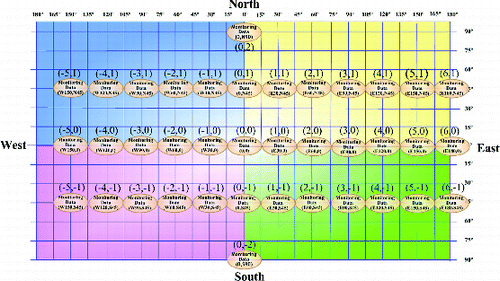
(a) presents the layout of the ultrasonic array with an interval phase of 30° for longitude and 45° for latitude. The total number of sensors is 38. The mapping numbers of the sensor nodes are marked in brackets as shown in . shows the monitoring space that corresponds to the ultrasonic array in . shows the longitude–latitude map of the monitoring space.
Figure 6. Application case and experimental system.
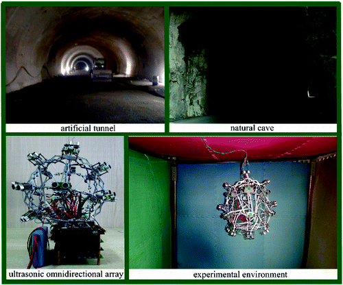
Figure 7. (a) Layout of the ultrasonic array and (b) the corresponding monitoring space.
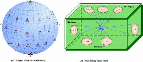
Figure 8. Longitude–latitude map of the monitoring space in the experiment.
5.1. Monitoring system initialization
A variety of environmental factors are initially considered to allocate the initial working time for each sensor node, including the material of the monitored object, the growth rate of the monitored deformation, the monitoring distance, and the monitoring angle. A comprehensive evaluation matrix is established based on the data shown in .
Given that the degree of contribution by index j to the sensor is uj = [8.0; 4.5; 6.5; 1.0] (j = 1,2,3,4), the normal matrix E is calculated based on equations (3), (4), (6), and (7).
If the number of priorities is m, the clustering algorithm should be introduced to cluster the normal matrix E. For example, the self-organizing feature map (SOFM) network algorithm is introduced for clustering. shows the clustering results with 500 different training times.
Table 1. Environmental factors for comprehensive evaluation.
Table 2. Clustering results by SOFM algorithm with 500 different training times.
The sensor nodes are divided into four groups: {1, 2, 3, 4, 5, 9, 10, 11, 12}, {6, 7, 8}, {13, 14, 15, 16, 17, 18, 19, 20, 21, 22, 23, 24, 25}, and {26, 27, 28, 29, 30, 31, 32, 33, 34, 35, 36, 37, 38}.
We can obtain the synthetic index according to Equation (Equation5(5) ) as follows: hi = [0.0395; 0.0329; 0.0294; 0.0358; 0.0292; 0.0214; 0.0291; 0.0214; 0.0278; 0.0439; 0.0375; 0.0331; 0.0295; 0.0298; 0.0301; 0.0301; 0.0297; 0.0304; 0.0307; 0.0313; 0.0311; 0.0311; 0.0304; 0.0301; 0.0396; 0.0165; 0.0162; 0.0162; 0.0158; 0.0155; 0.0158; 0.0158; 0.0160; 0.0160; 0.0160; 0.0164; 0.0165; 0.0225] (i = 1,2,…38).
Based on the clustering results, the clustering mean for each group was calculated as follows: Δh1 = 0.0344, Δh2 = 0.0311, Δh3 = 0.0240, and Δh4 = 0.0165. The ratio coefficient of clustering means ki (i = 1,2,3,4) was obtained according to Equation (Equation10(10) ): k1 ≈ 0.32; k2 ≈ 0.29; k3 ≈ 0.23; k4 ≈ 0.16.
When δ1 = δ2 = δ3 = δ4 = 1, the entire system cycle time is 180 s. According to Formulae (8), (9), and (10), the initialization working time for the different priorities were t10 = 6.11 s, t20 = 5.54 s, t30 = 4.39 s, and t40 = 3.06 s. Based on the calculated results above, the initial scan time for each sensor node is determined.
5.2. Deformation detection
Each sensor node works within the specific allocated time above, and the initial measurement value S (p,q,0) is considered the reference value.
Suppose a deformation safety threshold ΔS = 3 mm, if the sensor node with the mapping number (1,1) has a measured value of , then the deformation occurred within the monitored area. If we set λ1 = 0.6, λ2 = 0.3, λ3 = 0.1, the following results can be obtained according to equations (13) and (14): t1 ≈ 21.18 s, t2 ≈ 10.59 s, t3 ≈ 3.53 s.
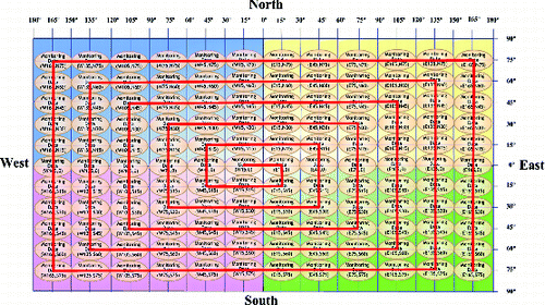
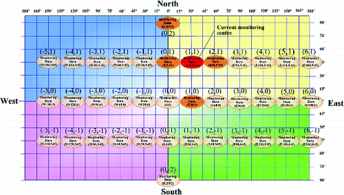
Given that sensor node (1,1) detected a deformation in its monitoring area, its online working priority level is increased to 1 and it becomes the current monitoring centre with new working time t1 = 21.18 s. Its monitoring area is marked in red colour in the longitude–latitude map (). The additional four sensor nodes around the centre node (1,1) become the auxiliary monitoring nodes, which are marked in orange in the longitude–latitude map (). Their online working priority levels are equal to 2 with new working times t2 = 10.59 s. The online working priority levels of the remaining sensor nodes are reduced to the lowest, level 3, with new working time t3 = 3.53 s. After each monitoring cycle, the system discovers a new area where a deformation has occurred. shows the process by which the current monitoring centre becomes the sensor node (0,1) and the old monitoring centre, sensor node (1,1), becomes an auxiliary monitoring node in the monitoring cycle.
Figure 9. Current monitoring centre is sensor (1,1).
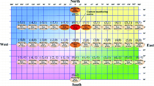
5.3. Deformation localization
As shown in , the monitoring cycle is designated as r, ΔS(0,1,r) = 13 mm, ΔS(−1,1,r) = 10 mm, ΔS(1,1,r) = 8 mm, ΔS(0,2,r) = 9 mm, ΔS(0,0,r) = 9 mm. ΔS(−1,1,r) is the maximum value; thus, the deformation occurred between the subspace monitored by sensor (0,1) and the subspace monitored by sensor (−1,1).
Figure 10. Current monitoring centre is sensor (0,1).
5.4. Deformation tracking
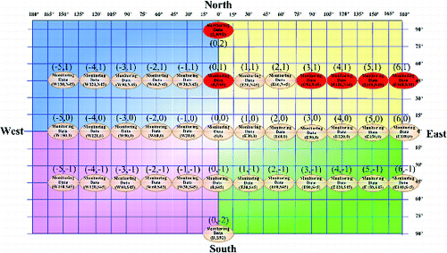
After each working cycle, the system selects a new monitoring centre to capture the dynamic deformation. As shown in , the monitoring centres are sensor nodes (0,1), (0,2), (3,1), (4,1), (5,1), and (6,1).
Figure 11. Monitoring centres in the longitude–latitude map.
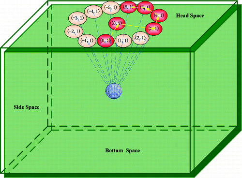
According to the results above, the path of the deformation can be tracked in the monitoring space, as shown in .
Figure 12. Tracking of the deformation path in the monitoring space.
6. Conclusions
A geographic mapping model based on an ultrasonic omnidirectional array for underground structural deformation monitoring has been established. The features of the technical method are as follows.
Establishing an ultrasonic spherical array allows all-around monitoring of structural deformation in underground space. The proposed method is insensitive to colour, light, and electromagnetism. Therefore, it can be used in adverse environments, including darkness, dust, smoke, and strong electromagnetic interference.
By establishing a longitude–latitude plan or map of the monitoring space, the monitoring information in the 3D space is mapped into a latitude and longitude plan. Therefore, visual plane management of the spatial monitoring information is possible.
Once the ultrasonic array is installed, the initial work time of each sensor node is determined by considering a variety of environmental factors and using an intelligent clustering algorithm. In the subsequent time, if the monitoring structure is in a safe state, each sensor node works with the initial working time. However, if the monitoring structure is not in a safe state, the working time is dynamically adjusted. If a monitoring space is given more areas of concern, then the sensor responsible for the corresponding monitoring region is also given more working time.
The proposed method automatically detects, localizes, and tracks the deformation by analysing the monitoring information, which is displayed on the earth longitude–latitude map.
The method has a wide scope of applications. It can be used to monitor the gradual changes in objects, such as structural deformation, as well as to monitor rapid changes in targets, such as somebody breaking into a controlled space.
Acknowledgements
The authors would like to thank the project supported by the National Natural Science Foundation of China (grant No. 61174006) and the project supported by the Fundamental Research Funds for the Central Universities (grant No. CDJZR10120016).
References
- Akcin H, Kutoglu HS, Kemaldere H, Deguchi T, Koksal E. 2010. Monitoring subsidence effects in the urban area of Zonguldak Hardcoal Basin of Turkey by InSAR-GIS integration. Nat Hazard Earth Sys. 10:1807–1814.
- Armesto J, Arias P, Roca J, Lorenzo H. 2008. Monitoring and assessing structural damage in historic buildings. Photogramm Rec. 23:36–50.
- Baillie I, Griffith P, Jian X, Dixon S. 2009. Implementing an ultrasonic inspection system to find surface and internal defects in hot, moving steel using EMATs. Paper presented at: 35th Annual Review of Progress in Quantitative Nondestructive Evaluation; Chicago, IL; p. 1711–1718.
- Bassett RH, Kimmance JP, Rasmussen C. 1999. An automated electrolevel deformation monitoring system for tunnels. Proc Inst Civ Eng Geotech Eng. 137:117–125.
- Bhalla S, Yang YW, Zhao J, Soh CK. 2005. Structural health monitoring of underground facilities – technological issues and challenges. Tunn Undergr Sp Tech. 20:487–500.
- Dragomir LO, Herbei MV. 2012. Monitoring the subsidence phenomenon in Petrosani city using modern methods and technologies. Environ Eng Manag J. 11:1349–1354.
- Fekete S, Diederichs M, Lato M. 2010. Geotechnical and operational applications for 3-dimensional laser scanning in drill and blast tunnels. Tunn Undergr Sp Tech. 25:614–628.
- Ferri M, Mancarella F, Seshia A, Ransley J, Soga K, Zalesky J, Roncaglia A. 2010. Fabrication and packaging techniques for the application of MEMS strain sensors to wireless crack monitoring in ageing civil infrastructures. Smart Struct Syst. 6:225–238.
- Ghosh D, Chakravarty D. 2012. Integration of DInSAR technique and conventional methods through GIS for verification of quantified surface changes. J Indian Soc Remote Sens. 40:179–190.
- Lee IM, Truong QH, Kim DH, Lee JS. 2009. Discontinuity detection ahead of a tunnel face utilizing ultrasonic reflection: laboratory scale application. Tunn Undergr Sp Tech. 24:155–163.
- Lyer SR, Sinha SK, Schokker AJ. 2005. Ultrasonic C-scan imaging of post-tensioned concrete bridge structures for detection of corrosion and voids. Comput-Aided Civ Inf Eng. 20:79–94.
- Malinowska A, Hejmanowski R. 2010. Building damage risk assessment on mining terrains in Poland with GIS application. Int J Rock Mech Min Sci. 47:238–245.
- Michael JK. 2005. Monitoring ground deformation in tunnelling: current practice in transportation tunnels. Eng Geol. 79:93–113.
- Naruse H, Uehara H, Deguchi T, Fujihashi K, Onishi M, Espinoza R, Guzman C, Pardo C, Ortega C, Pinto M. 2007. Application of a distributed fibre optic strain sensing system to monitoring changes in the state of an underground mine. Meas Sci Technol. 18:3202–3210.
- Park HS, Lee HM, Adeli H, Lee I. 2007. A new approach for health monitoring of structures: terrestrial laser scanning. Comput-Aided Civ Inf EngEng. 22:19–30.
- Popiolek E, Hejmanowski R. 2008. Forecasting and monitoring of underground mineral seam exploitation influence. Paper presented at: 21st World Mining Congress; Cracow, Poland; p. 135–149.
- Ukai M, Miyamoto T, Sasama H. 1996. Development of inspection system of railway facilities using continuous scan image. Paper presented at: 5th International Conference on Computer Aided Design, Manufacture and Operation in the Railway and Other Advanced Mass Transit Systems; Berlin, Germany; p. 61–70.
- Walker G, Hitchcock A, Rasmussen C, Farnham D. 2006. Monitoring the impact of tunnel construction on existing infrastructure and its successful implementation for the Airside Road Tunnel, Heathrow. Paper presented at: 10th Congress of the International Association for Engineering Geology and the Environment; Nottingham, UK; p. 1–13.
- Wang TT, Jaw JJ, Chang YH, Jeng FS. 2009. Application and validation of profile-image method for measuring deformation of tunnel wall. Tunn Undergr Sp Tech. 24:136–147.
- Wang TT, Jaw JJ, Hsu CH, Jeng FS. 2010. Profile-image method for measuring tunnel profile - improvements and procedures. Tunn Undergr Sp Tech. 25:78–90.