
Abstract
The Egyptian Mediterranean coast was examined for the vulnerability to sea-level rise using the coastal vulnerability index (CVI), which was derived from the geologic and physical characteristics of the coast. This paper is the first to apply the CVI along the Egyptian coasts. The coast has different geomorphologic aspects ranging from steep-slope-rocky cliffs to gentle sloping deltaic sediments. Although the coast is under low tidal effect and low height waves, results showed that more than one-third of the 1000 km long coast is severely vulnerable to sea-level rise. Unfortunately, the area under high vulnerability to sea-level rise comprises the densely populated Nile Delta coast. National actions should be implemented to safeguard the entire coast at the threatened locations.
1. Introduction
Coastal zone is a broad term that describes the area under the influence of coastal processes, such as coastal erosion and inundation. The offshore limit of the coastal zone may extend to several kilometres until the continental shelf, whereas the landward limit may be several kilometres in sedimentary beaches and tens to hundreds metres in rocky and cliffy beaches. Coastal areas host the majority of the world population, industrial, and trade activities. There is a worldwide concern about the sea-level rise and its impact upon coastal environments, particularly low-lying river deltas and coastal flats. Potential consequences of sea-level rise include acceleration of shoreline erosion, inundation of wetlands and estuaries, contamination of water resources, and threats to socio-economic activities as well as infrastructure. Although there are different estimates of the anticipated sea-level rise, recent figures report an increased rate of 2.5 mm/yr (Cazenave et al. Citation2008). Planning and management of coastal zone entail prediction of coastal retreat and potential erosion caused by sea-level rise. The assessment of coastal vulnerability to sea-level rise is therefore a key issue at the national and international scales. The response of coastal areas to sea-level rise is contingent to the nature of the geologic setting, topography, and physical characteristics of the coastal area. For example, rocky and cliffy beaches are resistant to erosion and sea-level rise than muddy and sandy beaches, which are vulnerable to sea-level rise. Also, flat coastal areas are more vulnerable to inundation by seawater than steep sloping coasts. In addition, high waves convey more energy and possess devastating impact upon coasts than low waves.
The Egyptian coastlines extend for more than 3000 km along the Mediterranean and Red Seas. Due to the geologic, geomorphologic as well as geographic setting, the Mediterranean Sea coast (1000 km) differs from the Red Sea coast. Coasts along the Mediterranean Sea are relatively extended and comprise deltaic sediments, sand dunes, lakes and lagoons, salt marshes, mud flats, and rocky beaches. On the other hand, the Red Sea coast is generally narrow and mountainous. Significant occurrence of coral reefs and mangrove beaches is a common aspect of the Red Sea coast. Natural resources of Egypt, particularly energy and mineral resources as well as major industrial and economic centres, occur mainly along the Mediterranean and Red Sea coasts. The coastal zone of Egypt faces many problems, such as shoreline erosion, deterioration of coastal lagoons, excessive land use, pollution from oil industry and transport, and the anticipated sea-level rise. Coastal erosion and deterioration of coastal lagoons are a direct influence of the hydrologic regime change in the Nile Delta caused by the construction of the High Dam in 1960s and the stoppage of sediments and flood water from reaching the Mediterranean Sea. Frihy Citation(1994) reported that the three promontories (tips) of the Nile Delta: Rosetta, Baltim, and Damietta were eroded between 1955 and 1983 at rates of 114 m/yr, 9 m/yr, and 31 m/yr, respectively. Ali Citation(2011) classified the Burullus Lake along the Nile Delta coast as a hyper-eutrophic water body with bad environmental conditions due to the discharge of drainage water. The Nile Delta, which extends from Alexandria to Port Said, consists of deltaic sandy beaches of medium to very fine sand. It hosts the majority of the country's population and constitutes the bread basket of the country. The Nile Delta is flanked by a calcareous rocky plateau (550 km long) west of Alexandria known as the North Coast, where limestone ridges and rocky headlands of marine origin occur along the coast. To the east of the Nile Delta, a coastal sand dune field (200 km long) interrupted by a shallow lake, El-Bardawil Lagoon, occurs along North Sinai. The majority of population and industrial activities along this coast occur at Alexandria, Damietta, Port Said, Rosetta, Matrouh, and El-Arish. Sea-level rise, particularly along the Nile Delta coast (250 km long), was a big concern due to the topographic nature of the delta. Hereher Citation(2010) reported that 31% of the Nile Delta will be inundated if the sea level rises by 100 cm above its current level. This will be accompanied by relocation of millions of people southward to the present shoreline, contamination of water resources, and loss of fertile agricultural land. If the delta subsidence, which is estimated at 4.5 mm/yr along the northern part of the Nile Delta (Mariner et al. Citation2012) is coupled with sea-level rise, the impact will be triggered.
One of the most common and direct methods to assess the coastal vulnerability to sea-level rise is the coastal vulnerability index (CVI), which was developed by Gornitz et al. Citation(1994) to assess the coastal vulnerability to sea-level rise due to erosion and/or overwhelming by seawater. In the CVI, a number of variables influencing the forces occurring along the coast are multiplied mathematically together to yield an index representing the response of the coast to the summation of these variables together. Then the risk along the coast is classified according to the value of this index. Thieler and Hammar-Klose Citation(1999) modified the CVI by reducing the number of variables in the Gornitz et al. Citation(1994) index to be more effective and applicable. In addition, the US Geological Survey (USGS) considered the following six variables in CVI calculation: geomorphology, shoreline erosion/accretion rates, coastal slope, relative sea-level rise, mean significant wave height, mean tidal range, as follows:where a = geomorphology; b = coastal slope (%); c = relative sea-level rise (mm/yr); d = shoreline erosion/accretion rate (m/yr); e = mean tide range (m); and f = mean wave height (m).
In this index, each variable is assigned to a numerical value ranked on a linear scale from 1 to 5 corresponding to the severity of this factor, which ranges from very low to very high value depending on the coastal development and process along this coast. The CVI comprises two types of variables: geologic variables including geomorphology, coastal slope, and shoreline erosion/accretion rate; and physical variables including the relative sea-level rise, mean tide range, and the mean wave height. Ranges of each variable are shown in . By applying the CVI equation, the resultant value is assigned to the following ranges: very low CVI (1), low CVI (2), moderate CVI (3), high CVI (4), and very high CVI (5). Index values less than 3 means that the coast is not vulnerable to sea-level rise. However, index values greater than 3 reveal that the shore is at significant risk of inundation. Many other studies have incorporated a socio-economic parameter into the CVI. However, this study is designed to highlight the natural parameters and to be as consistent as the scheme used by the USGS. The CVI has been applied in many previous studies, such as Hammar-Klose et al. Citation(2003), Pendleton et al. Citation(2005), Rao et al. Citation(2008), and Kumar et al. Citation(2010). Although most of these previous studies operated CVI for coasts under high tides (2–4 m), some others have been carried out along micro-tidal coasts of the Mediterranean (e.g. Doukakis Citation2005; Özyurt & Ergin Citation2010). The present study aims to apply the CVI to the Mediterranean coast of Egypt ( in order to determine zones susceptible to inundation by seawater by any anticipated rise at the regional scale. The nature of the local geologic and physical conditions of the Egyptian Mediterranean coast, which comprises cliffs, beaches, sand dunes, and lagoons, are examined thoroughly.
Table 1. Limits of the geologic and physical variables used to calculate CVI (modified after Thieler and Hammar-Klose Citation(1999)).
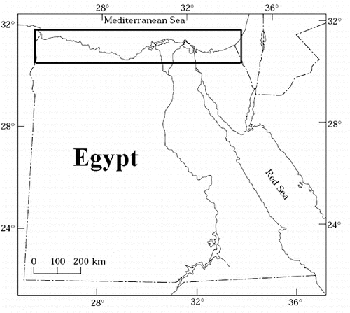
Figure 1. The location of the Egyptian Mediterranean Sea coast.
2. Data and methodology
2.1. The geologic parameters
2.1.1. Geomorphology
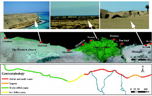
Morphology and coastal landforms play a major role in determining the impact of sea-level rise. The Mediterranean coast of Egypt, which extends for 1000 km, is divided into three different geomorphologic regions (): the western region, which constitutes the coastal 550 km of the Western Desert (known as the North Coast); the middle region represents the Nile Delta coast with a length of 250 km; and the eastern region extends for 200 km in North Sinai. The geomorphology of the 5-km-wide coast was extracted from geomorphological maps of the Mediterranean coastal plain assisted by a single image from the moderate resolution imaging spectroradiometer (MODIS) satellite (). Although the spatial resolution of the image is poor (250 m), the geomorphological features of the Egyptian Mediterranean coast are easily distinguishable from the maps and from the literature as well. The MODIS image, which represents a standard 16-day composite VI (MYD13Q1) product, was acquired from the USGS open access resources. It consists of 12 bands of reflectance layers (250 m spatial resolution) in the visible and the near infrared bands; layers of vegetation products, such as the normalized difference vegetation index and the enhanced vegetation index; and layers of data quality. The blue, red, and middle infrared bands have been stacked together to form a false colour composite image of the region. Geomorphologic aspects of the region were best visualized when the image was displayed using the combination of these three bands. Field visits, previous experience of the Mediterranean coastal area, geologic maps of the coast, and many previous studies along the coast were used as ancillary data to validate the information obtained from the satellite image. Earth Resources Data Analysis System (ERDAS) Imagine and ArcMap software have been used to process the satellite data and to prepare maps.
Table 2. Satellite data utilized in the present study.
Figure 2. The geomorphology of the Mediterranean Sea coast of Egypt. Top: ground photos of the different geomorphologic aspects. Middle: a false colour composite of MODIS image showing the entire coast with the locations of the main towns. Numbers in the satellite image refer to lakes Burullus and Manzala (1 and 2, respectively), and 3 is the Bardawil Lagoon. Bottom: the geomorphological units of the coast.
2.1.2. Coastal slope
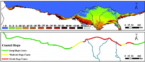
Coastal slope is a crucial factor, if not the most important, in determining the CVI, because the gentle sloping coasts should retreat faster than the steep sloping coasts with any rise in the sea level. A nearly global topographic database with high spatial resolution was generated by the Shuttle Radar Topography Mission (SRTM) onboard the Space Shuttle Endeavour during its 11-day mission in February 2000. A worldwide, finished, and seamless digital surface models are available and can be accessed at the Consortium for Spatial Information web portal (http://srtm.csi.cgiar.org/). The entire Egyptian Mediterranean coast is covered by two contiguous digital elevation model (DEM) tiles (42/6 and 43/6) with 90 m spatial resolution and 1 m vertical resolution (). The spatial resolution for the DEMs is fairly suitable as no finer resolution DEMs are available. The two DEMs were mosaicked together in ERDAS Imagine and a subset image showing the coastal area was generated in order to prepare an elevation map of the coast, from which the coastal slope was calculated. The coastal slope of a region is expressed in three ways: as a gradient, as a percent, or in degrees. The most common expression is the percent, which is the ratio of the difference in latitude to the horizontal distance of two points perpendicular to the shoreline. In this study, the slope of a distance from the shoreline landward to 5 km perpendicular to the coast was determined by dividing the difference in elevation at the sea level (zero level) and the elevation at 5 km southward of the coast. For example, if the elevation at 5 km south of the coast is 100 m, then the coastal slope is [(100 m − 0 m)/5000 m]100, which equals 2%, and this means that the area has a gentle coastal slope according to Thieler and Hammar-Klose Citation(1999). Thematic map of the coastal-zone elevation with 5-m-elevation intervals was produced using ArcMap software. The coastal slope was then calculated from the elevation map.
2.1.3. Shoreline erosion and accretion
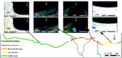
Erosion and accretion patterns indicate the dynamics of the coast. The rate of shoreline erosion and accretion throughout the entire coast was estimated from the occurrence of the shoreline in very old Landsat multispectral scanner (MSS) images with 57 m spatial resolution acquired in 1972 and in most recent Landsat enhanced thematic mapper plus (ETM+) images with 28.5 m spatial resolution acquired in 2005. The entire coast was covered by seven adjacent images from the MSS sensor and six adjacent images from the ETM+ sensor. The images, which were acquired from the USGS open access resources, were free from clouds and were geometrically rectified to the Universal Transverse Mercator projection (WGS-84). Atmospheric correction and radiometric normalization were applied to the images. The shoreline position of the coast was digitized in ArcMap as appeared in each MSS image and in the corresponding location in ETM+ images. The erosion/accretion pattern was estimated from the displacement of the shoreline between the two dates. The category of displacement in m/yr was estimated and modified after Thieler and Hammer-Klose Citation(1999).
2.2. The physical parameters
Due to the limitations of the data, as no continuous monitoring for wave height, tidal range, and sea-level rise along the coast, these physical parameters were obtained from the previously published data on the Mediterranean coast of Egypt. Wave action has a seasonal pattern in terms of direction and intensity. Low north-west waves prevail during spring and summer, whereas relatively higher north and north-west waves occur in winter. The average wave height of the Mediterranean coast of Egypt as reported by Frihy et al. Citation(2003) is 0.5 m. Thus, a value of 1.0 ( was applied in the CVI equation throughout the entire coast. The coast is characterized by a micro-tidal pattern, where low range of 20 cm (Manohar Citation1981) was recorded. El-Fishawi Citation(1989) installed water-level gauges to monitor tidal variation along three locations at the Mediterranean coast of Egypt, namely Alexandria, Rosetta and Burullus. Water-level data reveal a tidal range between 16 and 88 cm and not exceeding 24 cm for the monthly readings. That means a value of 5.0 is assigned for this parameter in the CVI equation (. The sea-level rise along the Mediterranean coast of Egypt was reported by many studies with a value of 1.8 mm/yr at Alexandria to 2.8 mm at Port Said (Frihy et al. Citation2010). In this study, the CVI was calculated by applying a value of 2.0 in the CVI equation to the area from the Libyan border until Port Said, where the sea-level rise is 1.8 mm/yr. On the other hand, the rest of the coast east of Port Said, where the sea-level rise equals 2.8 mm/yr takes a value of 3.0 in the CVI equation.
2.3. Calculation of the CVI
After identifying the geologic (geomorphology, coastal slope, and coastal erosion) and physical (sea-level rise, tidal range, and wave height) parameters of the entire coast from the source data, the variables of each parameter were arranged in an attribute table. The whole coast was divided into discrete 5 km segments and all variables have been assigned to the corresponding numerical values for each segment (from 1 to 5). The CVI was calculated using the previous equation by multiplying the six parameters for each 5 km segment. The product map, which highlights the rating of the CVI, could be used by developers, policy- and decision-makers for coastal management.
3. Results and discussion
3.1. Coastal geomorphology
Most of the Egyptian Mediterranean coast occurs along the North Coast extending from Alexandria until the Libyan border at El-Salloum for about 550 km. This coast is a rocky beach consisting of Pleistocene calcareous rocks with a sloping nature of vertical cliffs making the majority of the shoreline inaccessible to people with only 15% of this 550-km-long coast inhabited, suitable for swimming, and under development (Frihy Citation2009). This may partly interpret why the North Coast is abandoned except for relatively small towns, such as Matrouh, El-Salloum, and the newly constructed resort villages. The area between Alexandria and El-Alamine (for about 100 km) is generally low cliffy coast. The numerous protruding heads at this coast, as appear in the MODIS image, reveal the rocky nature of this coast. The remaining eastern 450 km Mediterranean coast includes the Nile Delta shore and the North Sinai coast. The delta coast is composed of flat deltaic sediments for 250 km along the Mediterranean Sea as a result of the long-standing flooding of the Nile River. The shoreline is backed by coastal flats, sabkhas, and sand sheets. Two shallow coastal lakes, the Burullus and Manzala, occur along the Nile Delta coast and are separated from the Mediterranean Sea by narrow and flat coastal strips. The delta coast has a dark tone in the MODIS image. The Sinai coastal plain (200 km) constitutes a deltaic beach for the western 40 km (El-Tineh plain) as a part of the Nile Delta, where the defunct Pelusiac Nile branch was terminated at the Mediterranean Sea. The easternmost 75 km section of Sinai is covered by quaternary aeolian sand deposits (with a yellowish tone in the MODIS image). Coastal crescentic (barchan) sand dunes up to 2 m high occur along the coast. The middle 85 km of Sinai coast is occupied by the shallow El-Bardawil Lagoon, which is separated from the Mediterranean Sea by a concave coastal sandy barrier about 1 km width and 1 m above sea level. According to Thieler and Hammar-Klose Citation(1999), the numerical values corresponding to the coastal geomorphology of the entire Mediterranean coast are (: 1.0 (rocky cliffed coasts) for the region extending from El-Alamine to El-Salloum along the North Coast (about 450 km); 3.0 (low cliffs) for the region between Alexandria and El-Alamine (about 100 km); 4.0 (lagoons) for the Bardawil Lagoon (85 km) in North Sinai; and 5.0 (deltaic and sandy coasts) for the remaining coast (365 km), which represent the Nile Delta coast and the delta of Wadi El-Arish in North Sinai extending to Rafah.
3.2. Coastal slope
The DEM image () reveals that the entire Mediterranean coast has three different types of coastal slopes depending on Thieler and Hammar-Klose Citation(1999) scale: 1 – steep-slope coasts (highlands are close to the shore in the DEM image), which have coastal slopes greater than 11%. These coasts take the value of 1.0 and occur mostly along the North Coast (for 450 km) and along the easternmost 50 km of Sinai; 2 – moderate-slope coasts (11.5%–5.5%), which occur from Alexandria to El-Alamine (for about 100 km) and along a coastal stretch for 30 km west of El-Bardawil Lagoon at Sinai (highlands are somewhat far from the coast in the DEM image). These coasts take the value of 2.0; and 3 – gentle slope coasts (<2.2%), which occur along the entire Nile Delta coast (250 km) and the rest of Sinai coast (120 km) (the back shore is flat and extended for tens of kilometres in the DEM image). These coasts take the value of 5.0 and are considered the most susceptible locations for inundation by seawater.
Figure 3. Top: the topography of the Egyptian Mediterranean coast as extracted from DEM. The blue colour refers to the sea level. Bottom: the classification of the coastal slope.
3.3. Shoreline erosion/accretion rates
Comparing the location of the shoreline along the entire coast as extracted from old and recent satellite Landsat images reveals four classes of coasts in terms of stability and erosion/accretion pattern. The majority of the coast includes stable coasts due to the rocky nature. This is obvious along the North Coast from Alexandria westward to the Libyan border, which extends for 550 km. There is another stable stretch of 40 km occurs east of El-Arish until Rafah in Sinai, where shoreline position did not exhibit any changes in satellite images. El-Banna and Hereher Citation(2009) attributed stability of this coast to the straightness of this section as no major protruding parts to be eroded or major embayment to receive sediments, as well as there is no engineering structure on the coast to disrupt wave-induced longshore sediment drift. Stable coasts take the value of 1.0 in the CVI equation (. Accretional coasts more than 5 km long have not been observed throughout the coast, however, localized pockets of accretion were observed. The remaining coastal plain exhibits erosion with different degrees. Low-erosion coasts occur mostly along the North Sinai for 100 km from the west of El-Arish until the western margins of El-Bardawil Lagoon. In addition, there is a small stretch (25 km) east of Alexandria belongs to this category. Low-erosion coasts take the value of 3.0 (). Moderate-erosion coasts were observed at four locations throughout the coast totalling about 190 km. These locations exhibit erosion within −1 m/yr and −2 m/yr, and occur within the Nile Delta fan (). These coasts take the value of 4.0 (). The most dangerous and vulnerable locations to coastal erosion were observed at five locations either at the terminal parts of the Nile River branches (Rosetta, Damietta and the defunct Sebenetic branch along lake Burullus) or at the downdrift sides of the main coastal engineering structures constructed along the coast, such as harbours. These severely eroded beaches total 180 km and erosion rates at these locations exceeded 2 m/yr in the satellite data. The location of the headland at Damietta promontory is clearly moved southward in satellite images () by erosion for about 2000 m between 1972 and 2005. After the construction of the Aswan Dam in early 1900s and the High Dam in 1960s to control Nile flooding, the cut-off of sediments by the dams had converted the formerly constructive delta to a wave-dominant delta (Stanley & Warne Citation1993). The mouths of the two present and the defunct Nile branches (Stanley et al. Citation1992) were the locations where significant erosion occurred (El-Raey et al. Citation1999). The other two locations of severe erosion were observed in Sinai just east of the entrance of the Suez Canal and east of El-Arish Harbour. Erosion at these locations is attributed to the construction of two long jetties to protect these projects from siltation. However, localized accretion on the updrift side (western side) not exceeding 5 km along the coast was observed.
Figure 4. Shoreline position as extracted from MSS (1972) and ETM+ (2005) images, and the corresponding classification of coastal erosion pattern along Egypt's Mediterranean coast according to Thieler and Hammar-Klose Citation(1999).
3.4. Coastal vulnerability index
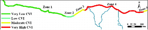
To understand the calculation of the CVI, a 5-km segment along the Rosetta promontory shore at the Nile Delta coast was chosen with the limits of the six parameters as [(5 × 5 × 2 × 5 × 5 × 1)/6]1/2, where geomorphology equals 5 (delta), coastal slope equals 5 (gentle slope), sea-level rise equals 2 (1.8 mm/yr), coastal erosion equals 5 (severe erosion), tidal range equals 5 (less than 1.0 m), and wave height equals 1 (less than 0.55 m). The CVI at this segment is 14.43, which means a very high CVI (>5.0). The CVI of the entire coast, which consists of about 200 segments each of which is 5-km long and 5-km width is shown in . The CVI ranges are: very low CVI (1.0–2.0, Zone 1); low CVI (2.0–3.0, Zone 2); moderate CVI (3.0–4.0, Zones 3 and 4); and very high CVI (<5.0, Zone 4). summarizes the lengths and occurrence of each zone with its geological, physical as well as CVI category designations. Coasts, which exhibit very low coastal vulnerability to sea-level rise account for the western 400 km of the Egyptian Mediterranean coast (Zone 1), where rocky and cliffy shores exist. Shorelines under the impact of very high coastal vulnerability include the entire Nile Delta coast and extend to El-Arish in North Sinai for a total length of 420 km (Zone 4). The remaining 180 km of the Egyptian Mediterranean coast is divided into: low-CVI coast for 60 km at El-Alamine area (Zone 2); moderate CVI coast for 90 km west of Alexandria (Zone 3); and for 30 km west of Rafah in Sinai (Zone 5).
Table 3. Occurrence of the CVI categories of Egypt's Mediterranean coast.
Figure 5. The CVI of Egypt's Mediterranean coast with the four categories of vulnerability.
The CVI incorporates all the geologic and physical characteristics of the coast and produces an integrated perspective of the response to sea-level rise. In an earlier study, Hereher Citation(2010) considered only one parameter, i.e. topography, to highlight areas prone to sea-level rise along the Nile Delta. Although he got a concise view about areas theoretically susceptible to drowning by sea-level rise, this parameter only can lead to misleading results in areas such as North Sinai or the North Coast, i.e. shores apparently differ if they are not looked under the interaction of more than one parameter. The coast in El-Arish area in North Sinai has a sloping nature (; however, when incorporating the other parameters, its CVI reveals a very high vulnerability to sea-level rise. This is because the sloping coast at this area is covered by coastal sand dunes. Although these dunes can form temporal or short-term barriers to any fluctuations of the sea level, any prolonged sea-level rise will loosen sand grains leading to severe erosion, which eventually accelerates devastation of the coastal area. In other area, i.e. south of Alexandria, the elevation map () shows the occurrence of significant areas below the mean sea level; however, when incorporating the other parameters into the CVI equation, it reveals a moderate vulnerability to sea-level rise. This is attributed to the geomorphologic nature of the shoreline, which is mostly a coastal ridge of hard calcareous rocks with high resistance to erosion.
If the socio-economic parameter is taken into account in the CVI equation, which means that heavily populated areas should be of high sensitivity to any anticipated sea-level rise, the situation would be even worse because unfortunately, there is a coincidence between the occurrence of high vulnerable areas to sea-level rise with the major population centres. For example, the Nile Delta coast, which has the highest vulnerability to sea-level rise, hosts the significant population centres and industrial activities of the country. In contrary, the areas of very low CVI, such as the North Coast, are the least inhabited. Results of the present study can be verified not only by the interested, but also by the public persons, where inhabitants of unprotected coastal regions along the Nile Delta usually witness occasional episodes of inundation by seawater after periodic sea surges in winter. Water stays for several weeks at lower area and eventually forms sabkhas, where table-salt extraction is famous. Other areas, such as the North Coast, usually lack the phenomenon of inundation.
With regard to the protection measures established to safeguard the shoreline of the Nile Delta from the current erosion or inundation of low lands by any anticipated sea-level rise, many engineering structures were constructed, particularly at the Nile River three promontories (Rosetta, Burullus, and Damietta), ranging from seawalls (5 km at Rosetta and 6 km at Damietta) to concrete breakwater systems at Baltim and Damietta. Although these structures were effective to protect the coastline and have saved many important areas from being lost to the sea, their downdrift sides (the eastern side) have experienced pronounced erosion (El-Nahry & Doluschitz Citation2010). In addition, they are very expensive and have negative aesthetic impacts on the coast. However, they can be implemented to protect low lands of relatively high importance, which are prone to inundation. Results obtained from the present investigation highlight the need to execute a series of national strategy to confront sea-level-rise hazards. Armouring shorelines, raising the backshore throughout the Nile Delta coast and beach nourishment with suitable sediments to the eroded beaches are just options to be considered. Fortunately, the recent international highway crossing the Nile Delta coast was intentionally designed to be at 1–2 m above the mean sea level that acts as a defence line along the coast. At the international level, the Mediterranean Sea countries should initiate regional plans and cooperative policies in order to reduce carbon dioxide emissions to the atmosphere to minimize global warming impacts and to alternate experiences and provide technical support to highly vulnerable and impacted countries, such as Egypt.
4. Conclusions
Despite of data limitations regarding some parameters to implement the CVI, this study is the first to apply this index throughout the Egyptian Mediterranean coast. The integration of the coastal parameters in one index can produce a comprehensive overview of the geologic/physical interactions along the coast. The main conclusions of this study are: (1) diversity of coastal landforms in terms of geomorphology and coastal slope is the most important factor to determine the response of the coast to sea-level rise; (2) the Egyptian Mediterranean coast is mostly non-vulnerable to any anticipated sea-level rise for the majority of the coast, but it is highly vulnerable and under the threat of sea-level rise along the Nile Delta and North Sinai coasts; (3) the results of the present study provide a first step to understand and aid long-term planning and decision-making for coastal development; (4) national and international integration are required to provide ideas and suggestions to protect the Nile Delta from inundation by seawater; and (5) comprehensive research work should be initiated to afford suitable alternatives with minimum negative impacts to safeguard the shorelines of the vulnerable locations.
Acknowledgements
The author would like to thank and appreciate the comments and suggestions of two anonymous reviewers for this manuscript.
References
- Ali M. 2011. Impact of drain water on water quality and eutrophication status of Lake Burullus, Egypt, a southern Mediterranean lagoon. Afr J Aquat Sci. 36:267–277.
- Cazenave A, Lombard A, Llovel, W. 2008. Present-day sea level rise: a synthesis. C R Geosci. 341:761–770.
- Doukakis E. 2005. Coastal vulnerability and risk parameters. Eur Water. 11/12:3–7.
- El-Banna M, Hereher M. 2009. Detecting temporal changes of shoreline positions and erosion/accretion rates using remote sensing and their associated sediment characteristics along the coast of north Sinai, Egypt. Environ Geol. 58:1419–1427.
- El-Fishawi NM. 1989. Coastal erosion in relation to sea level changes, subsidence and river discharge, Nile Delta coast. Acta Mineral Petrogr. 30:161–171.
- El-Nahry AH, Doluschitz R. 2010. Climate change and its impacts on the coastal zone of the Nile Delta, Egypt. Environ Earth Sci. 59:1497–1506.
- El-Raey M, Sharaf El-Din S, Khafagy AA, Abo Zed AI. 1999. Remote sensing of beach erosion/accretion patterns along Damietta–Port-Said shoreline, Egypt. Int J Remote Sens. 20:1087–1106.
- Frihy OE. 1994. Nile Delta shoreline changes: aerial photographic study of a 28-year period. J Coast Res. 4:597–606.
- Frihy OE. 2009. Morphodynamic implications for shoreline management of the western-Mediterranean sector of Egypt. Environ Geol. 58:1177–1189.
- Frihy OE, Deabes E, El Gindy A. 2010. Wave climate and nearshore processes on the Mediterranean coast of Egypt. J Coast Res. 26:103–112.
- Frihy OE, Deabes E, Elsayed W. 2003. Processes reshaping the Nile Delta promontories of Egypt: pre- and post protection. Geomorphology. 53:263–279.
- Gornitz VM, Daniels RC, White TW, Birdwell KR. 1994. The development of coastal risk assessment database: vulnerability to sea-level rise in the US southeast. J Coast Res. 12:327–338.
- Hammar-Klose ES, Pendleton EA, Thieler ER, Williams SJ. 2003. Coastal vulnerability assessment of Cape Cod national seashore (CACO) to sea-level rise (Open-File Report no. 02-233). Reston (VA): United States Geological Survey.
- Hereher M. 2010. Vulnerability of the Nile Delta to sea level rise: an assessment using remote sensing. Geomatics Nat Hazards Risk. 1:315–321.
- Kumar T, Mahendra RS, Naak S, Radhakrishnan K, Sahul KC. 2010. Coastal vulnerability assessment for Orissa state, east coast of India. J Coast Res. 26:523–534.
- Manohar M. 1981. Coastal processes at the Nile Delta coast. Shore Beach. 49:8–15.
- Mariner N, Flaux C, Morhange C, Kaniewski D. 2012. Nile Delta's sinking past: quantitative links with holocene compaction and climate-driven changes in sediment supply. Geology. 40:1083–1086.
- Özyurt G, Ergin A. 2010. Improving coastal vulnerability assessments to sea-level rise: a new indicator-based methodology for decision makers. J Coast Res. 26:265–273.
- Pendleton EA, Thieler ER, Jeffress SW. 2005. Coastal vulnerability assessment of golden gate national recreation area to sea-level rise (Open-File Report no. 2005-1058). Reston (VI): United States Geological Survey.
- Rao KN, Subraelu P, Rao T, Malini B, Ratheesh R, Bhattacharya S, Rajawat A. 2008. Sea-level rise and coastal vulnerability: an assessment of Andhra Pradesh coast, India through remote sensing and GIS. J Coast Res Conserv. 12:195–207.
- Stanley DJ, Warne AG. 1993. Nile Delta: recent geologic evolution and human impact. Science. 260:628–634.
- Stanley DJ, Warne AG, Hugh DR, Bernasconi MP, Chen Z. 1992. The late quaternary north-central Nile Delta from Manzala to Burullus lagoons, Egypt. Nat. Geogr Res Explor. 8:22–51.
- Thieler ER, Hammar-Klose ES. 1999. National assessment of coastal vulnerability to sea-level rise, US Atlantic coast (Open-File Report no. 99-593, 1 sheet). Woods Hole (MA): United States Geological Survey.