
Abstract
Unless decision makers urgently exhibit a proactive approach to earthquake preparedness, Istanbul will be the most vulnerable city for the expected great Marmara Earthquake and Tsunami. Because Istanbul has the highest population density (larger than some European countries) and is the commercial/industrial centre of Turkey, the high seismic potential of the North Anatolian Fault (NAF) in the Sea of Marmara is a great risk for Istanbul.
The Kocaeli and the Düzce earthquakes, which were the last two seismic events to occur in the eastern part of Marmara in 1999, dramatically demonstrated the vulnerability and lack of awareness and preparedness of Istanbul and the Marmara region for natural disasters. Although Istanbul is 90 km from the epicentre of the earthquake that occurred in 1999, it caused severe damage to many buildings and great loss of life. An earthquake of even greater magnitude is now expected to occur within the submarine fault system that extends west of the 1999 ruptured segments under the Sea of Marmara which is near Istanbul.
Although Istanbul is susceptible to seismic hazards and a destructive earthquake and tsunami are anticipated to occur in the Marmara Sea, necessary seismic risk mitigations have not been taken. Disaster preparedness studies, which are conducted by the government and the municipality of Istanbul, are not sufficient or rapid enough. School students, especially, in their unsafe school buildings, are the most vulnerable to earthquakes. The disaster-related issues are so serious because of the students >23 million in Turkey or ∼4 million students in Istanbul, and frequently repeated disaster events.
1. Introduction
While natural disasters are increasing and intensifying, many countries are conducting studies for a common strategy against such disasters in order to save human lives and prevent property loss. The main purpose is to establish international cooperation in order to improve disaster prevention and risk mitigation. According to analyses prepared by Centre for Research on the Epidemiology of Disasters (CRED) based on the EM-DAT datasets in 2015, during the 20 year period between 1994 and 2013, 1.35 million people were killed by 6873 natural disasters in global scale. This shows that approximately 68.000 people have died per year and 218 million people were affected by these natural disasters. Currently, disaster-related deaths are decreasing slightly; however, it may seem as increased because of four high mortality years (2004 Indonesian, 2008 Wenchuan, 2010 Haiti and 2011 Japan disasters). In total, 22000 people died in 2013, because of the disasters. The year of 2014 is the most striking of the year in last 30 years in term of disaster-related life losses, which are a little under 10,000 people. This table is promising for the future in terms of reduction in loss of lives.
Data on global economic disaster loss since 1980, in US dollars based on 2013 US dollar values adjusted by unit of gross domestic product (GDP), show an increase to the present day. It is noted that a small number of mega disasters, dominating the level of global economic losses in any one year, greatly influence the historic record of economic losses (Mitchell et al. Citation2014).
In 1950, two-thirds of the world's population lives in rural areas. Hundred years later, this ratio will be reversed (WRR Citation2014). Rapid urbanization and mega cities, which are defined to house a population exceeding 10 million, began to emerge with the beginning of the third millennium. This trend still continues. More people are living in mega cities. In total, 3.76 billion people who are 53% of world population live in urban areas (WDR Citation2014). Currently, there are about 19 such cities, but it is predicted to increase to about 27 in 2025 (UN Citation2008). In 2013, the urban population in Turkey is >54 million (Worldbank Citation2013). The urban areas are always under the risk related to management natural disasters, such as earthquakes, tsunamis, floods, landslides, tornados, storms, etc.
Marmara is a most crowded region of Turkey with the largest building stock. The population in eight cities in the Marmara region is over 21 million. Based on Turkish Statistical Institute (TUIK Citation2014a), people over 14 million live in Istanbul. It is the largest urban settlement in Europe and Middle East, and the sixth-largest city proper in the world. Istanbul's contribution to the Turkey's budget is around 40%. The most important disadvantages of emergencies in which the daily routines are suspended, are the loss of lives and loss of property.
Children are more vulnerable than adults in emergency events because they are emotionally and physically delicate. Thus, they must be urgently protected and defended by governments, parents and regulations. This task is our priority for the health of the next generations. Approximately 1.2 billion students are enrolled in primary and secondary schools; of these, 875 million school children live in high seismic risk zones all over the world (Hancilar et al. Citation2014).
Turkey is a country under the threat of natural disasters and has a population of 77,695,904 (TUIK Citation2014b). In total, 30% of the population (22,692,174 of 77,695,904) is children by the end of 2012.
There are >500,000 college students in 50 universities and 3 million students in over 3000 elementary and high schools in Istanbul. It could be said that there are roughly 4 million students in Istanbul in total.
In this study, the students and the conditions of the schools will be evaluated. In this evaluation, population, building stocks, geological threats and risks, assessment of educational buildings after 1999 Gölcük and Düzce earthquakes and preparations against disasters for children will be covered.
2. Turkey and disasters
Turkey is under the danger of natural disaster as a result of its position which is on a young and active mountain zone called Alp-Himalaya based on geological point of view. The natural disasters and their effect based on loss of life and loss of property are as Earthquake and Tsunamis (55%), landslides (30%), floods (8%) and other natural disasters. Turkey has lost 300,000 people because of the natural disasters since 1950. In addition, 158,283 people have lost their lives because of Earthquakes (the data of Gökçe et al. (Citation2008) have been revised up to date). About 70% of the earthquake-related deaths happened in urban areas, which have a big proportion of the country's population, with the remainder living in rural parts of Turkey. According to the Seismic Zoning Map of Turkey, based on maximum acceleration, 66% of Turkey's land is in first and second degree hazard zones.
Sixty-eight per cent of the population live in cities. Poverty in Turkey is increasing annually. Citizens living below poverty standards are about 18.56% of the inhabitants. Turkey has one of the world's 20 largest economies. Turkey is a country of upper–middle income (gross national income per capita $4,086–12,615). Income distribution of the country is uneven and unbalanced. A major part of the national income is in the control of a minority of the population. There is a big gap between the poor and the rich concerning income distribution. The upper-middle-income countries take up a high proportion of geological disasters when measured in terms of deaths and economic losses. Many are rapidly developing countries, such as Iran, Romania and Turkey (Mitchell et al. Citation2014). According to WRR (Citation2014), Turkey has a medium-high risk concerning fast growing urbanization.
The high rate of population growth is promoting demands for housing and is increasing unemployment, both of which are giving rise to irregular urbanization. Based on the results of general building census of Turkey Statistical Institution, Turkey has >20 million dwellings. Irregular urbanization causes high disaster loses and with the high increasing on population cause poverty. Therefore, disaster losses can be diminished by fight against poverty.
Turkey is one of the most vulnerable countries to natural disasters, especially earthquakes. More than 80% of the population lives in areas prone to natural disasters, such as earthquakes, floods and landslides. These areas also generate approximately 83% of the GDP. For the time interval between 1900 and 2015 (until April), Turkey experienced 239 earthquakes equal to or greater than M 5.0 on the Richter scale. In total, these caused over 100,000 casualties and about 600,000 buildings were severely damaged. The 1999 Marmara Earthquake was solely responsible for 17,000 deaths and 200,000 homeless and resulted in a fiscal cost of some US$2.2 billion. Strengthening the coordination of disaster preparedness and response, and increased enforcement of building codes at the national and local levels would go a long way towards mitigating the impact of natural disasters.
School-age children comprise a significant percentage (%30) of actual Turkey's population and it must be to build a better future for them, so building safe and seismic-resistant schools for children and young people is one of the important priorities of pre-disaster studies. Besides, one must keep in mind that the geologic events that can cause catastrophic damage cannot be stopped or postponed. When schools are closed because of damage caused by an earthquake, education will be delayed. Consequently, the life of society will be disrupted and getting living conditions back to normal will be time consuming. In the long term, it is obvious that repairing, retrofitting and reconstruction of school buildings will be particularly difficult and expensive tasks, especially as government resources will be restricted after an earthquake.
3. Istanbul and earthquakes
Istanbul has been damaged by earthquakes in the past. In order to evaluate the damage caused by past earthquakes, seismic activity, soil properties, building stock and population should be investigated historically and the necessary precautions should be evaluated based on the determined worst case scenario.
Istanbul has high population changes because of the wars and natural disasters. 1600 years of Istanbul's history is under the governance of Byzantine Empire, Ottoman Empire and Turkey. The urbanization of Istanbul started with Megaras around 680 BC. First residents found Kalkedon (Kadıköy) which was known as “State of Blind” afterwards, the development of the urban was towards to the European Side. The population of Istanbul decreasing during the Crusades period began to increase with the professional families to be invited from Anatolia in the period of Fatih Sultan Mehmed II. The population and residential stock in Istanbul have been continuously and rapidly increased after XVth century up to present day with the exception of some periods that the population has declined as a result of migrations. Today, 18.5% of Turkey's population resided in Istanbul. According to the 2014 data of the TUIK (), >14 million people live in Istanbul. While the population of Istanbul in 1927 was 806,863, it reached 12 million in the 2000s. Istanbul's population has increased 18-fold in last 80 years and 70-fold in 500 years. Only one-tenth of the population lives in villages. The rest lives in cities.
Table 1. Populations of Istanbul between 1927 and 2014 (TUIK Citation2014a).
Table 2. Total population of affected provinces, numbers of deaths and injuries in 1999 Kocaeli earthquake.
The land of the City of Istanbul has an area of 5000 km2. According to building census of TUIK 2011, in the metropolitan area of the City of Istanbul, approximately >1 million buildings and 3.7 million dwellings have been built and 80% of the residential stock is illegally constructed. Also, there are >6000 public buildings. The calculated duration for an anticipated major earthquake (Mw ≥ 7) in the Sea of Marmara was probably maximum 30 years with the probability of 20%–65% (Barka Citation2000; Parsons Citation2004). First half of determined duration has consumed. The countdown has begun. According to a prediction done by the Japan International Cooperation Agency (JICA), an earthquake of magnitude ranging between 6.9 and 7.7 will occur around Istanbul in the near future (Griffiths et al. Citation2007).
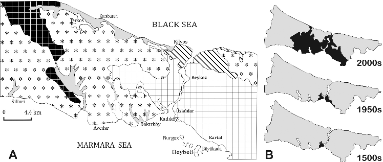
Although the quality of structures in Istanbul are questionable, the structures in central Istanbul are built on Paleozoic rocks which are very strong and have hard rock which are very strong and have “hard rock” properties. These hard rocks are covered with less strong, old tertiary rocks (). These two different groups are defined as Istanbul pact consisting of metamorphism constituting most of the Istranca Mountains and piles that do not exhibit metamorphism (Özgül Citation2009).
Figure 1. (A) Simplified geological map; (B) The historical development of Istanbul residential areas between 1500s and 2000s.
There have been >300 earthquakes and 40 tsunamis around Istanbul between 2100 BC and 1900 AD (Altınok & Ersoy Citation2000). Six of 38 seismic activities that are greater than 7.0 in Richter scale happened in the twentieth century (Ambraseys & Finkel Citation1991; Ambraseys Citation2002). 1912 Şarköy-Mürefte Earthquake, 1935 Hayırsız Ada Earthquake, 1953 Yenice Gönen Earthquake, 1963 Mudanya Earthquake, 1964 Manyas Earthquake, 1967 Mudurnu (Sakarya) Earthquake, 1999 Kocaeli Earthquake and Tsunami, 1999 Düzce Earthquake are the most destructive in that century.
The 1999 Kocaeli Earthquake caused serious structural damage to 3073 buildings, moderate damage to 13,339 buildings, minor damage to 12,455 buildings, and 454 deaths, 1880 injuries occurred in residential areas of Istanbul. Most of the deaths in Istanbul, namely 274 citizens, were in the Avcılar district (Özmen Citation2000) ().
Total population of eight cities that were affected by 1999 Kocaeli Earthquake was around 14.5 million. During the earthquake, 17,480 people who are 0.121% of total population have lost their lives as shown in . An earthquake with the same magnitude in the same place would have caused 25,000 people to die today based on this statistics.
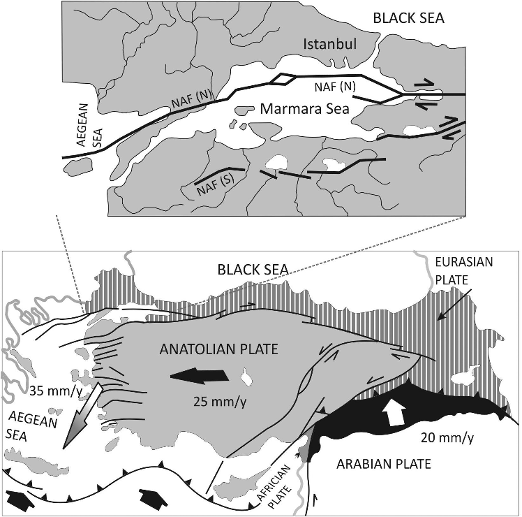
People who live in Istanbul, as well as other people living in the Marmara Region, are afraid of the great submarine earthquake expected in the Marmara Sea, which is close to Istanbul. The 1999 Earthquakes transmitted stress to the Marmara segment of NAF so the expected earthquake is anticipated to occur in the Marmara Sea. NAF is a 1200-km-long dextral strike-slip fault zone that was formed by progressive strain localized in a generally westerly widening right-lateral keirogen in northern Turkey, mostly along an interface juxtaposing subduction-accretion material to its south and older and stiffer continental basement to its north. The NAF formed approximately 13–11 Ma ago in the east and propagated westward. It reached the Sea of Marmara no earlier than 200 ka ago, although shear-related deformation in a broad zone had already commenced there in the late Miocene era. The fault zone has a very distinct morphological expression and is seismically active. A major M ≤ 7.6 event is expected in the next half century with an approximately 50% probability in this segment (Şengör et al. Citation2005).
At present, the Sea of Marmara Region is located in an area of enhanced and increasing stress due to severe earthquakes (Ms >7) such as 1912 Ganos and 1999 Kocaeli events. In other words, the previous earthquakes have brought forward the next earthquake in the Sea of Marmara. The faults in this region therefore indicate a serious seismic hazard, particularly for Istanbul, where over 14 million people live. How many segments of the NAF in the Marmara Sea will break? What would be the magnitude of the next earthquake? These subjects have been under debate by researchers for ten years (Le Pichon et al. Citation2001; Armijo et al. Citation2002; Şengör et al. Citation2005)
The 1509 Earthquake which occurred near Istanbul is considered to have been the largest earthquake (M7.7) and most catastrophic hazard of all. In this earthquake, 5000 people lost their lives and 1000 buildings were destroyed in and around Istanbul. At that time, the population of Istanbul was around 500,000, however it is considered around 160,000 (Ambraseys & Finkel Citation1990). Building stock was about 17,000. It is approximately assumed that 1% of the population died and 5.88% of the housing demolished in the 1509 Earthquake. If an event similar to the 1509 Earthquake reoccurs one more time, what will be losses of the life and property around the Marmara Region? Approximately 5% of >1.5 million buildings, which is about 90,000 will be heavily damaged. An assessment in terms of loss of people reveals that 1% of 14.5 million people living in Istanbul or 145,000 people will be died.
On the other hand, when the death rate (1%) in 1509 Earthquake is projected today, estimated death toll will probably be about 145,000 people compared to about 14.5 million people living in Istanbul.
Griffiths et al. (Citation2007) claim that a possible shake like 1509 Earthquake can cause destruction the buildings >250,000. In addition to this, if the tsunami possibility and the density of population living in coastal areas are taken into account then the scenario emphasized above is neither exaggerated nor unreasonable. The possibility of a tsunami generated by seismic shaking in the Sea of Marmara, has not been taken into consideration in any scenarios suggested at all. Unfortunately, any tsunami generation in the Sea of Marmara has only been discussed by non-experts who are not part of any paleo-tsunamic or recent tsunamic study. In fact, the idea that tsunamis may only occur in the ocean or in an open sea environment, is just a myth. Water inundations like tsunamis can even occur in the lakes of dams, because not only earthquakes, but also submarine landslides, volcanic eruptions, meteoric impacts and nuclear tests might generate tsunami waves. This negligence is a drawback in risk management for future disasters. Although some tsunami simulations and scenarios for the Sea of Marmara have been prepared by Turkish and Japanese experts with the cooperation of the Istanbul Metropolitan Municipality (IBB) and JICA, so far there have been no plans regarding evacuation or defence or mitigation of damage, nor public awareness, especially for children.
4. Istanbul and tsunamis
Tsunamis generally occur due to vertical displacements of a submarine fault or the motion of large volumes of water. While there are several documented cases of tsunami generation by volcanic eruptions and landslides, most of them are attributed to earthquakes. Submarine landslides can generate large tsunamis that are hazardous along coasts near the source. The submarine sliding might be triggered by an earthquake or other slider mechanisms. Tsunami is a Japanese word that describes a “harbour wave” and is used within the scientific community to describe a series of waves that travel across the ocean with exceptionally long wavelengths (up to 150 km in the open ocean). As the waves approach a coastline, the speed of the waves decreases as they are deformed within shallower waters. During this process of wave deformation, the height of the waves increases significantly and as the waves strike the coastline they often cause widespread flooding across low-lying coastal areas as well as loss of life and property.
Turkey is surrounded by the seas predominating active tectonics. It is known that numerous tsunamis had caused damage to the residential area in Turkish coast (Kuran & Yalciner Citation1993; Altinok & Ersoy Citation2000; Yalciner et al. Citation2002). The coasts of the Marmara Sea have been also struck by tsunamis as in other coastal areas of the Aegean, Mediterranean and Black Seas; over 40 tsunamis have been recorded in the Marmara Sea between 120 and 1999 AD (Altinok et al. Citation2001a, Citation2001b).
NAF is a long continental and dextral strike-slip discontinuity between the Anatolian and Black Sea blocks as a result of the collision between the Arabian and Eurasian plates and the westward escaping of the Anatolian block as depicted in (Barka & Kadinsky-Cade Citation1988; McClusky et al. Citation2000). Historical seismicity in the Marmara Sea is extremely high, especially for the northern branch of the emerged NAF (Ambraseys & Finkel Citation1991; Ambraseys & Jackson Citation2000; Ambraseys Citation2002). Before the 1999 Earthquakes, magnitudes had already reached M7 and more in 1509, 1719, May 1766, August 1776, 1894 and 1912. Historical Tsunamis evidenced in the Marmara Sea, e.g. those associated with the strong 1509 and 1766 Earthquakes broke some submarine segments of the NAF in the vicinity of Istanbul, and future submarine events are expected to produce tsunamis that can be triggered either by submarine coseismic displacements or by land sliding.
Figure 2. The map of simplified Neotectonic outlines of Turkey and North Anatolian Fault (NAF) branches around Marmara region (partly adopted by Barka and Kadinsky-Cade (Citation1988) and McClusky et al. (Citation2000)).
The 1894 Earthquake occurred in the area consisting of Istanbul and Izmit, and subsequently, the sea inundated up to 200 m towards inland along the coastal area of Istanbul. According to witnesses, the sea was receded immediately after the earthquake and then the sea upraised violently with run-up heights reaching possibly 6 m locally (Altınok et al. Citation2001a; Yalciner et al. Citation2002). Sea waves were observed by many witnesses in Istanbul and in the Princes Islands, within an area probably larger than the one inferred from observations gathered after the 1999 Kocaeli Earthquake, an event which is often compared to the one of 1894. Submarine landslides were also most probably triggered by the shock, and caused the rupture of a submarine cable line (Ambraseys Citation2002).
The most recent tsunami in the Marmara Sea was triggered by the 1999 Kocaeli Earthquake whose ruptured extent was partially submarine. It produced locally up to 10-m high waves (average run-up 2.5 m) on the southern shore of the gulf and was most probably caused by several small faults and local submarine failures (Altinok et al. Citation2001b). The major submarine landslides of the Marmara Sea were studied by Gazioglu et al. (Citation2005) using advanced visualization and geomatic systems (digital terrain models, DTM; geographic-information systems, GIS; image-processing systems; high-resolution seismic and bathymetric data).
Istanbul was built on the seven hills and has not flat topography. The city has very long coast of a few hundred kilometres. But shoreline of these coasts is very narrow. Vehicular traffic on the coastal roads is so crowded for almost every hour of every day. The width is very narrow in the coasts and generally varies between 50 and 500 m. The regions such as the river mouth in the Ataköy district which is very crowded in terms of both population and traffic density at all times of the day, has a large shore line. If a tsunami wave strikes such a coastal area, its results could be quite lethal and destructive. One metre of height is sufficient to be a destructive wave along the narrow shore line. This was the case in the most recent 1999 Kocaeli Earthquake and in the 1894 Istanbul Earthquake.
The findings that emerged during archaeological excavation works on the marine infill area in the Yenikapı (ancient Teodosius harbour, Istanbul) revealed some tsunamigenic events. These data showed that the remains of many vessels, which found under the tsunami deposits in the subway excavation area, were destroyed by a tsunami dated as around the 6th century (Algan et al. Citation2009).
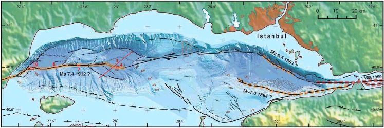
Normally, the rapture on the NAF could not be able to generate a tsunami because of strike-slip movement but resulting shock could trigger a submarine sliding that could be caused a destructive wave. Moreover, the existence of vertical-slip faults in the Sea of Marmara has been revealed with submarine seismic profiles that obtained by some offshore researches. The source of submarine landslides in the Sea of Marmara are unconsolidated soft muds deposited on the slopes of the three great basins, deeper than 1000 m, as shown in (Armijo et al. Citation2002). These soft and muddy stationary materials can slump by a seismic shaking into the basin-floor. Thus, such a submarine landslide can generate a tsunami wave.
Figure 3. The basins in Sea of Marmara (Armijo et al. Citation2002).
Historical and recent data indicate that the long coastlines of Turkey have substantial potential concerning destructive tsunamic waves. These records reveal that at least 100 tsunamis had been affected the coasts of Turkey along a time period of 3500 years (from 1500 BC to 2000 AD). About forty historical tsunamis appeared in the Sea of Marmara. A tsunami wave occurred in the Sea of Marmara can reach within 5–20 minutes to the surrounding coasts (Hébert et al. Citation2005). Landslide-related tsunami is probably be more dangerous than others concerning destructive effects because of huge waves locally.
5. Why must children and schools take priority?
What will happen when disaster strikes schools that are unsafe and unprepared? The answer is that children and teachers will be killed, disabled, injured and traumatized and also school supplies and equipment will be damaged or destroyed. Furthermore, children's education will be disrupted which brings about loss of social and cultural life as well as loss of post-disaster resources. Lives will be forever altered. The problem has been getting worse rather than better. New schools are being built every day without safety in mind.
It is known that children are very sensitive physically and emotionally and more vulnerable in emergencies than adults. Hence, they need to be protected and defended by governments, parents and regulations. This task should be our main priority for the health of the next generations. According to WDR (Citation2014), the 26.3% portion of world population consists of children aged 0–14.
Many of these children study in hazard-prone areas of the world exposed to the dangers of disasters such as earthquakes, fires, floods, landslides, volcanic activity, industrial accidents and other natural and man-made disasters. In the last decade, natural disasters occurred in countries such as Indonesia, El Salvador, Venezuela, Italy, Cambodia, USA, Indian, Pakistan, China and Turkey promoting high rates of child mortality. For instance, every year, half a million school-age children are suffering and being evacuated from schools because of floods and storm-surge as a result of heavy monsoon rains or cyclones. On the other hand, earthquakes do not affect only residential buildings but also cause the damages at hospitals and schools. Historical earthquakes reveal the fact that the vulnerability of school buildings is disproportionately high compared to other buildings. In 1999, the Chi-Chi Earthquake completely destroyed 43 Taiwan schools in the Nantou and Taichung area and a total of 700 schools nationwide were damaged. In 2001, the Gujarat Earthquake in India caused severe damage to 11,600 schools. In 2005, the Kashmir Earthquake resulted in the collapse of 8000 schools in the North-West part of the country and 1300 schools in Pakistan-administered Kashmir. UNICEF stated that in this earthquake, at least 17,000 school children died because children were attending morning classes. In the 2008 Sichuan Earthquake the rate of child mortality was substantial with the death of 19,000 students and the total destruction of about 7000 schools (Wisner Citation2006).
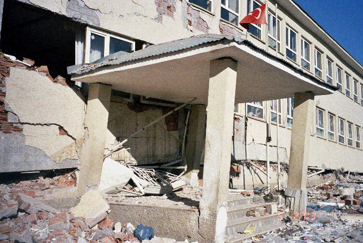
Turkey, as a country threatened by earthquakes, is situated at the upper levels of of child mortality. It can be recalled that during the 1999 Earthquake in Kocaeli, 43 schools were heavily damaged and 381 schools sustained slight to moderate damage. Schools in these areas were closed for four months, causing major disruption to the lives of families and children. In Istanbul, 90 km away from the epicentre, 50% of schools (820 of 1651 schools) were damaged (Erdik et al. Citation2003). In the Bingol Earthquake, out of 29 schools in the affected area, 4 school buildings collapsed completely, 10 were heavily damaged, 12 were slightly or moderately damaged and three undamaged (Çetin et al. Citation2003, Ersoy & Koçak Citation2003). Pictures taken of the earthquake-damaged schools during the Bingol Earthquake are presented in and .
Table 3. The loss of student and teacher and school damages occurred in the last six earthquakes in Turkey.
Figure 4. The dormitory building of Çeltiksuyu Basic Education School collapsed during the 2003 Bingol earthquake. Eighty-four students and teacher killed.
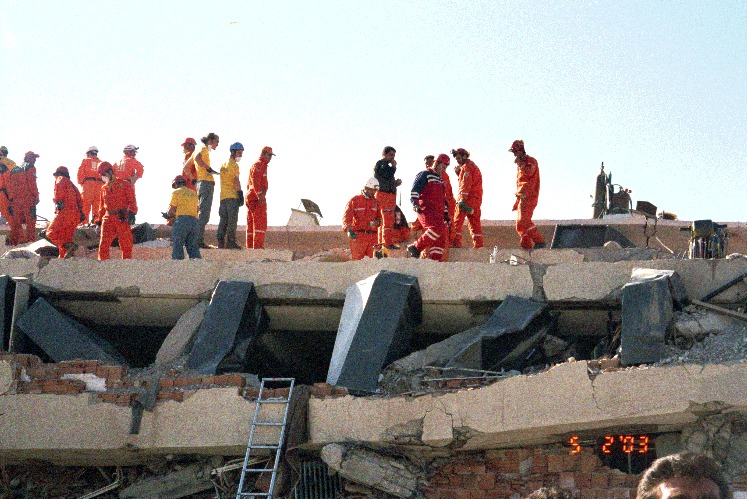
Figure 5. Celtiksuyu Basic Education School building damaged during the 2003 Bingol earthquake.
In total, 30.8% of population in Turkey is children under 14 years old based on 2014 TUIK data. Although the population in Turkey is getting older, the population is younger than the Europe. 41.1% of the population is between the ages of 0 and 24. In 2023, the children population (0–14) will be 21.2% and young population (15–24) will be 15.1% based on projections. In 2013, the number of total students was 22.7 million that consist of 1.1 million pre-school, 5.6 million elementary-school, 5.5 million middle-school, 3 million high-school, 2.5 million technical high-school students. The number of schools in 2011 was 28.408 with 330 students per school. The number of students per classroom is 30 for elementary and middle schools, 31 for high schools.
During the establishment of the Turkish Republic in 1923, 364,428 students in total were attending an average of 5,200 schools while the total number of students of only one university was 2914. Nowadays, the number of universities in Turkey has reached 196. Schools play a vital role in every community. Schools not only provide education, but also provide emergency shelters immediately after earthquakes. It is obvious that earthquake-hazard prone communities need earthquake-resistant schools. When schools are closed because of earthquake damage, education is delayed and social life is disrupted. Repairing, retrofitting and construction of school buildings are particularly difficult and expensive after an earthquake, especially when government resources are limited. The most important thing is that earthquake-threatened communities have earthquake-resistant schools to protect their teachers and children.
Nobody knows when or where the world's next devastating earthquake will strike. Disasters threaten thousands of lives, destroy millions of dollars worth of property and cause irreversible damage to the infrastructure. Disaster-affected countries have access to comprehensive recovery planning and accelerated financial support. The Istanbul Seismic Risk Mitigation and Emergency Preparedness Project (ISMEP) supported by the World Bank can be given as an example. Since 2006, many schools and public buildings have been retrofitted. The project has three components. These are (1) seismic risk mitigation for critical public facilities by retrofitting public schools, hospitals, etc.; (2) higher earthquake resistance: enhancing the emergency capacity of communities by knowledge and experience dissemination and through disaster preparedness education and raising awareness of disasters; and (3) enforcement of building codes.
6. Educational losses during the 1999 Kocaeli and Düzce earthquakes
On 17 August 1999, a magnitude of Mw 7.4 earthquake struck Kocaeli and affected severely some provinces such as Sakarya, Bolu, Bursa, Eskisehir, Yalova and Istanbul in north-western Turkey. The earthquake's hypocentre was at a depth of about 17 km. Its rupture distance was 120 km and it developed along the west four segments of the KAF Zone from Düzce to the Hersek Delta. On the surface, traces of the fault segmenting ruptured area displaced about 4.5 m of offsets with right lateral strike-slip motion. Seismic event caused huge economic losses in a densely populated and highly industrialized region of Turkey. The Kocaeli Earthquake was resulted with heavy damage of 66,441 residential and 10,901 commercial buildings, moderate damage of 67,242 houses and 9927 commercial buildings, minor damage of 80,160 residential and 9712 commercial buildings, and loss of 17,479 people and injuries of 43,953 people. The percentage of structural damage was reported as 48% in Kocaeli, 29% in Sakarya and 14% in the Yalova districts (Özmen Citation2000). Avcilar is a new residential area located at the western periphery of Istanbul, and takes place a distance about 90 km from the epicentre. The quake also created a great damage to buildings in spite of its long distance from main shock area. The percentage of heavily damaged buildings was 3.26 and the number of casualties was 274. 43 School buildings collapsed and 381 school buildings were damaged in the earthquake region. In total, 22 primary and 21 secondary-school buildings were damaged beyond repair. Besides, 267 primary and 110 secondary and vocational schools buildings had minor to moderate damage ().
Table 4. Provincial distribution of school buildings damaged in the 1999 earthquakes (Özmen Citation2000).
The distribution of damage based on Özmen (Citation2000) is different than the data of the Ministry of Education. The table based on the distribution of damage according to the Ministry of Education is given in .
Table 5. The distribution of damaged educational institutions based on the Ministry of Education.
Three months later, a new seismic shaking with a magnitude of Mw 7.2 was occurred around the Düzce province on 12 November 1999. A surface rapture of approximately 40 km began from the eastern end of a previous rapture and finished at the Bolu Tunnel around Kaynaslı. The maximum right-lateral offsets up to 4 m were measured with a vertical displacement of about 2 m around Efteni Lake. A total of 23,400 buildings were damaged either heavily or moderately, while 220,000 residential and 21,000 commercial buildings were damaged slightly. The total number of collapsed buildings (pancake collapse) was estimated to be in the range of 3000–3500. The Düzce Earthquake destroyed most of the retrofitted buildings to be damaged during the Kocaeli Earthquake (Erdik et al. Citation2003). The Although Public hospital and school buildings showed much better structural performance than residential buildings, educational sector were affected by the earthquake one more time: 178 teachers (142 active teachers and 36 retired teachers) and 1387 students died around Kocaeli, Sakarya, Yalova, Düzce, Bolu and Istanbul. 102 educational buildings were destroyed or damaged beyond repair and 1503 buildings were affected by minor to heavy damages ().
Table 6. The provincial distribution of damages of the educational buildings.
– show considerable damages to residential and commercial buildings, public facilities and infrastructures with substantial casualties around Kocaeli, Sakarya, Bolu, Düzce, Bursa, Eskisehir, Yalova and Istanbul districts at the east of the Marmara region. About 95% of all losses happened during the Kocaeli Earthquake.
Table 7. The provincial distribution of students and teachers died in the 1999 Kocaeli and Düzce earthquakes.
Table 8. The provincial distribution of prefabricated schools and classrooms which to be built in the temporary housing area of the earthquake region in 1999.
Table 9. The distribution of damaged school buildings.
7. Istanbul school buildings after earthquake
Although Istanbul is located about 90 km away from the Kocaeli earthquake area, 50% of its school buildings were damaged. After the 1999 earthquakes, formal responsibility for retrofitting, repairing and rebuilding school buildings was shifted to the Ministry of Education's Division of Investment and Facilities. Nearly 2500 public buildings in Istanbul were inspected with seismic resistant tests within the framework of the Istanbul Seismic Risk Mitigation and Emergency Preparedness Project (ISMEP), supported by the World Bank and European Investment Bank. For execution and coordination of the ISMEP Project, the Istanbul Project Coordination Unit (IPKB) was founded on February 1st, 2006 and is affiliated with Istanbul Special Provincial Administration. Istanbul Special Provincial Administration, Istanbul Project Coordination Unit and Provincial Disaster Management have been continuing studies related with the ISMEP Project. The ISMEP project is a significant attempt to implement essential principles of comprehensive disaster management. IPKB have been conducting proactive applications for preparation, damage reduction, emergency response and improvement required before, during and after disasters since 2006.
Roughly 1000 public buildings were planned for retrofitting in Istanbul in 2009. Retrofitting and construction studies for damaged and destroyed buildings began very late: 84 public buildings were retrofitted and 175 public buildings were rebuilt during the time interval between 1999 and 2006. Later, as a part of the ISMEP Project, the retrofitting studies of 315 schools and the rebuilding studies of 45 schools were completed after 2006. It was planned that 505 schools would be retrofitted by 2010 ().
Table 10. Schools and Istanbul seismic risk mitigation and emergency preparedness project (ISMEP).
IPKB will demolish and rebuild 13 more schools as a part of ISMEP in addition to 540 strengthened and 175 rebuilt schools until early 2015.
During the repair and reconstruction of schools, the reasons for the problems were not only financial but also due to legislation because the Ministry of Education, which is responsible for the strengthening of schools, encountered legislative issues with national institutions such as the Istanbul Gas Distribution Industry and Trade Joint Stock Company (IGDAS), the Anatolian Side Electricity Distribution Corporation (AYEDAS), the Turkey Electricity Distribution Corporation (TEDAS), Istanbul water and sewerage mana.gement (ISKI), Turkey Monuments Board, Bosphorus Reconstruction Directorate and the Board for the Protection of Cultural and Natural Heritage - the Ministry of Culture and Tourism. Legislation is necessary to correct these problems.
The efforts which have been done up to now are, of course, great. Nevertheless, it seems that these studies are not sufficient: a much more concerted effort of non-governmental organizations (NGOs), large communities and big companies is surely required together with the national will, although the collaboration of the media, NGOs and donors of charitable and large companies of Turkey, are examples to be appreciated. It should be remembered that time is running out rapidly and the expected earthquake is threatening unsafe schools. It must be kept in mind that earthquake-resistant schools are the centre for the creation of powerful brains and our children and future must not be sacrificed to earthquakes.
8. National school campaigns supported by Turkish media institutions and non-governmental organizations
Civil initiatives increased the enrolment numbers to schools and the building of schools after the 1999 Earthquakes. As an example, NGOs have supported governmental studies and have contributed to the reconstruction of school buildings. Indeed, civil initiatives have completed considerable projects and campaigns since 1999. As a result, numerous schools have been repaired or rebuilt. Thousands of students have been able to attend seismically-safe schools. Successful campaigns accomplished by NGOs and some media institutions are as follows.
8.1. “Father Sent Me to School” campaign
This campaign was held with the collaboration of The Association in Support of Contemporary Living (CYDD in Turkish) and a national newspaper, Milliyet under the support of the Ministry of Education.
Milliyet is the oldest newspaper in Turkey with one of the biggest circulations. The Association in Support of Contemporary Living, CYDD, is a NGO conducting studies especially for children, education and democracy. Its members consist of volunteers who are generally women. The campaign is called I have a daughter who will be a teacher in Anatolia. There is a school far away in there and Contemporary daughters of Modern Turkey (Kardelenler, Galanthus nivalis) are the other projects successively carried out by CYYD.
8.2. “Undamaged Schools” campaign
The Turkish newspaper, Hürriyet started a new campaign called Undamaged Schools with the collaboration of the Turkish Television Channel-D (Kanal-D in Turkish), Foundation of National Education, Middle East Technical University (Ankara), Yildiz Technical University (Istanbul) and Cukurova University (Adana district) after the 2003 Bingol Earthquake which caused the collapse of one dormitory building in which 83 students and 1 teacher died. The first target of this campaign is to check, using the earthquake-resistance test, the 190 primary boarding schools that are situated in 30 districts, located in the first degree of the Turkish Seismic Zoning Map.
8.3. “Hurray! Our school” campaign
This campaign was organized by the Foundation of Educating Children (TOCEV in Turkish) with the collaboration of the Ministry of Education and Private Television Channel called Show TV. The aim of this campaign is to repair the schools in villages. 185 schools in total have been repaired with the aid of the campaign in Adana, Adıyaman, Antalya, Bursa, Diyarbakır, Mardin, Zonguldak, Denizli, Izmir, Manisa, Bilecik, Kırklareli, Mersin, Gaziantep, Kahramanmaras, Canakkale, Edirne, Bingol, Batman, Siirt, Samsun, Ordu, Giresun, Bayburt, Elazıg, Gumushane, Erzurum, Erzincan, Mus, Bitlis, Van, Igdır, Ardahan, Artvin, Trabzon, Sinop, Tunceli, Kastamonu, Bartın, Karabuk, Çorum, Yozgat, Tokat, Kırıkkale, Kırsehir, Kayseri, Konya, Nigde, Afyon, Mugla, Balıkesir, Kutahya, Eskisehir, Sakarya, Cankırı, Nevsehir, Aksaray, Karaman, Mardin, Hakkari, Hatay, Osmaniye and Usak districts in the whole of Turkey.
8.4. “Two Schools per month for Education” campaign
This is a social responsibility project of MNG which is a big cargo company of Turkey. The campaign slogan is Cargo Bags in the Box, Children to School. In other words, it is an environmental campaign that is to be achieved with the collection of used plastic bags for re-use.
8.5. “Hundred Turkish Liras for School” campaign
Current and graduated students from the Middle East Technical University started this campaign where anyone can give 100 Turkish liras to build a new primary school. It was supported with exhibitions and concerts performed by famous singers and artists.
8.6. “Hundred Percent Support to Education” campaign
The Ministry of Education executed a campaign called “Hundred Percent Support for Education” which was arranged on 11 December 2003.
The aim of the project is to provide a quantitative solution for Turkey's educational problems. For the promotion of this campaign, the ministry allows a tax deduction for individuals and companies that make a donation to the school.
8.7. “Let's Girls to the School”: Education campaign for girls
The campaign called Let's girls to school was started in January 2003. The promoter of the campaign, UNICEF aimed to provide completion of 8 years of compulsory primary education and to solve the issue of the lowest enrolment and attendance rates of girls around 53 districts.
8.8. “Child-Friendly Schools Project”
UNICEF's Turkey branch has some school projects for contemporary improvement of the Turkish educational system and to bring academic standards to international levels. This is one of these campaigns.
8.9. “We are adding schools” campaign
One of Turkey's television channels, NTV, in concert with UNICEF Turkey arranged a campaign about enrolling school-aged girls based around National Independence and Children's Day starting on 23 April 2007. To increase the country's schools and classes, calls were made for donations during the various programmes of the television. 150 classrooms were constructed as a result of this campaign.
8.10. Turk Telekom's schools
Turk Telekom, which is the company providing Turkey's infrastructure for communication, is building educational facilities in various provinces of Turkey with the “Turk Telekom Schools” project that it started with the aim of investing in the future. Within the scope of the protocol signed with the Ministry of Education and the Ministry of Communications, >30,000 students will have a modern educational environment by means of 76 educational buildings to be completed within the framework of the “Full Support for Education” campaign. Turk Telekom aims to contribute to the social development of the students as well as their educations.
9. Disaster preparedness programmes for children
Disasters can leave children feeling frightened, confused and unsafe. Children exposed to disasters may respond by feelings of fear, sadness, or behavioural problems. Younger children may return to early childhood behaviour patterns, such as bedwetting, sleep problems, and separation anxiety. Older children may also display anger, aggression, school problems or withdrawal. Some children who have only indirect contact with the disaster but witness it on television may experience distress.
The way children cope with the effects of disasters or emergencies is often related to the reactions of their parents. They can feel and reflect the adults' fears and sadness. Parents and adults can make disasters less traumatic for children by taking steps. Parents are always the best support for children through disasters. One way to establish a sense of control and to build confidence in children before a disaster is to involve them in preparing a family disaster plan. After a disaster, children can contribute to a family recovery plan.
In Turkey, in order to increase awareness of school-age children against disasters, some training practises are conducted in schools during the week of the disaster that is repeated every year. These practices start with sudden and unannounced ringing of school bells as if a disaster had happened. During disaster practice, the students in the classrooms stop writing and drawing immediately, and drop, hold and cover themselves near chairs or lie in a foetal position called the life triangle on the floor under chairs. Afterwards, with instruction from their teacher, they calmly go out of the classrooms toward the school garden in order to stand together. This practice is often considered as a formality and is not taken seriously. Although teachers have very good attitudes during training, they do not have sufficient knowledge in detail for disaster preparedness. The manner of teachers is not philosophical and holistic. Training against other types of disaster such as tsunamis, landslides, floods, hurricanes, tornadoes, drought, global warming and cooling, heavy winter conditions, fire, terror, radiation, epidemic and pandemic disease, etc., are always ignored. In short, there is no holistic risk management in Turkey's schools now. All training has been focused into response after disasters. In contrast to this, training in schools must contain philosophical approaches to disasters and pro-active reactions. The training must be supported by visual materials to enhance their effectiveness. Parents and psychologists may join the school training for effective collaboration.
An additional problem about disaster preparedness related to building construction is the lack of awareness of non-structural hazards in Turkey. Classroom doors often open inwards, and shelving and laboratory equipment remain unfastened. However, the country is beginning to make some progress in this area. In the case of earthquakes, it is possible to let children go under school desks which are tough enough and have been produced since the beginning of 2001.
In 2014, Prime Ministry Disaster and Emergency Management Authority started “Disaster–Ready School Project” in order to increase the awareness of 17.5 million students and 800,000 teachers and raise a disaster-ready educational community.
10. Disaster-related governmental and private institutions in Turkey and some disaster relief initiatives
10.1. The Disaster and Emergency Management Authority (AFAD) under the Prime Ministry
AFAD established by Turkish Parliament under the Prime Ministry in 2009 for a single government institution to single-handedly coordinate and exercise legal authority in cases of disaster and emergencies. AFAD is an institution working to prevent disasters and minimize disaster-related damages, plan and coordinate post-disaster response, and promote cooperation among various government agencies. Turkey's transition process from crisis management to risk management began with the establishment of AFAD. AFAD currently has 81 provincial branches across Turkey in addition to 11 search and rescue units.
Over the past five years, AFAD successfully coordinated to Turkey's response to a number of devastating earthquakes and floods, among others, and helped survivors get their lives back on track. At the international level, AFAD completed successful missions to provide humanitarian assistance to nearly 50 countries around the globe. The agency currently runs a network of 25 state-of-the-art refugee camps where over 250,000 people enjoy regular access to housing, healthcare, education and psychological support.
10.2. Turkish Red Crescent (Kizilay in Turkish)
Turkish Red Crescent (Turkish: Turk Kızılayı (official) or Kızılay (for short)) is the largest humanitarian organization in Turkey and is part of the International Red Cross and Red Crescent Movement. The organization was founded by the Ottoman doctors to treat wounded and soldiers on the battlefield under the Ottoman Empire on 11 June 1868. Later on in 1923, the Society was renamed as the Turkey Red Crescent Association and finally in 1947 the organization named Turkish Red Crescent. It was renamed Kizilay by Mustafa Kemal Atatürk in 1935, after the foundation of the Republic of Turkey. Like its counterparts in other countries, it is an NGO. All Red Cross and Red Crescent organizations within the former Ottoman territories are the successors of the Turkish Red Crescent.
10.3. Turkish Medical Rescue (UMKE in Turkish)
This is a governmental organization consisting of members specially trained and equipped to intervene medically and save people immediately during disasters.
10.4. Provincial Disaster and Emergency Directorate of Istanbul Governorship (AYM in Turkish)
This association was founded to supply coordination and collaboration between concerned institutes and enterprises which are legally required to execute disaster preparation. The Provincial Disaster and Emergency Directorate has been implementing actions which consist of prevention, preparation, rapid reaction and redevelopment phases and has developed the strategy of prevention with the expression “be prepared” instead of the strategy of rescue which focused on treatment, all of which are part of its efforts to struggle with natural disasters. Consultancy studies regarding making people aware of preparation for disasters and preparing miscellaneous materials have been organized by the Preparation for Disaster Education in Schools
10.5. Disaster Coordination Centre of Istanbul Metropolitan Municipality (AKOM in Turkish)
AKOM was established with the support and finance of the World Bank in 2000. The AKOM Building has been constructed based on the Disaster Management Center in Los Angeles, CA, USA. AKOM's main aim is to provide coordination and cooperation between related agencies and units of the Metropolitan Municipality to mitigate the effects of any type of damage before a disaster, during the disaster and in the post disaster period. It coordinates the assignments of the Metropolitan Municipality by orders from the Mayor of IMM and the Crisis Center of the Province. AKOM carries out duties on five main topics. These are scientific and technical studies, studies about building safety, studies on vehicle-equipment and rescue staff, and other studies. Education and training studies for students are presented under the scientific and technical studies. AKOM has trained 70,000 people about fire, rescue and first aid. In addition, different types of books and handbooks are distributed to make citizens more conscious of earthquakes. Furthermore, AKOM gives a series of lectures about civil defence and risk mitigation options during earthquakes for the students of primary schools.
10.6. Minister of Environment and Urbanization -- Turkish Emergency Management Agency (TEMAD) and Disaster Affairs Directorate
The Turkey Emergency Management General Directorate (TEMAD) was established in 1999 after the two major earthquakes in Marmara, under the Prime Ministry with the support of the World Bank. The central government, including the Council of Ministers and TEMAD are the policy makers for disaster management in Turkey. The aims of TEMAD are to take the necessary measures in order to provide effective emergency management and to provide coordination between governmental organizations and private organizations that are related to emergency management and to conduct the activities of coordination in the utilization of all types of land, sea and air transport vehicles and rescue and relief equipment and to make arrangements that encourage voluntary organizations and individuals providing relief in emergency situations and to carry out other duties which may be assigned by the Prime Minister. TEMAD has been deployed in the capital city, Ankara. There are no educational functions in Istanbul.
10.7. European Natural Disasters Training Center (AFEM, Ankara) of Disaster Affairs General Directorate -- Minister of Environment and Urbanization
Eur–Opa, the European and Mediterranean Major Hazards Agreement was signed in order to facilitate collaboration concerning organization of disaster assistance and prevention and defence against major natural and technological disasters in the city of Strasbourg, dated 20 March 1987. Turkey, France, Greece, Italy, Spain, Luxembourg, San Marino, Malta and Portugal are parties to the agreement. Later, the European Office of the World Health Organization (WHO) joined this agreement. In this context, the community suggested the establishment of centres giving disaster education and training courses, developing and investigating disaster policies and the arrangement of various meetings. One of them is AFEM which was established in the city of Ravello, Italy, dated 27 April 1987 and is conducted by the Minister of Environment and Urbanization.
10.8. Natural Disaster Training Park -- Istanbul Metropolitan Municipality
IBB, in particular, aims to increase public awareness of earthquakes and other disasters. In order to achieve this goal, the Natural Disasters Training Park is intended to start construction at the beginning of 2009. It will have first aid, a shaking table, smoke training, fire extinguishing, a three-dimensional earthquake, liquefaction, tsunami simulations and a planetarium.
Natural disaster training parks realistically simulate the effects of earthquakes and fires and also help people gain the necessary experience in an enjoyable way, within a disaster scenario.
10.9. Disaster Preparedness Education Unit -- Boğaziçi University Kandilli Observatory and Earthquake Research Institute (KOERI in Turkish)
Boğaziçi University, Kandilli Observatory and the Earthquake Research Institute's Disaster Preparedness Education Program has its beginnings in a three-year project supported by the United States Agency for International Development and the Office of Foreign Disaster Assistance (USAID/OFDA) for the Istanbul Community Impact Project, which was awarded one year after the 1999 Kocaeli Earthquake. Its purpose was to contribute to the process of preparing the Istanbul area for the expected major earthquake. Financial administration of the project is through Boğaziçi University Foundation (BUVAK).
The goals of the unit were to increase community disaster awareness, address local unpreparedness and provide first response organization and skills throughout Istanbul in order to mitigate casualties and loss of property. The four objectives have been addressed.
During the first three years of the project, 14 other organizations contributed to the expansion of these objectives to other provinces (Bursa, Sakarya, Canakkale, Yalova and Kocaeli) and to the development of two more training curricula on Non-Structural Mitigation and Structural Awareness for Seismic Safety. At the end of the three year project, USAID OFDA granted a two-year extension in order to support the Turkish Ministry of Education in taking the Basic Disaster Awareness Training for Schools to 25,000 teachers and 50,000,000 children in Turkey's first and second degree earthquake areas, and to pilot non-structural and structural awareness training in Istanbul's trade vocational high schools.
The public education programmes developed by AHEP with the support of Boğaziçi University faculty and expert practitioners in the community are intended to be conveyed via existing governmental and NGOs and community activists through both volunteer and staff trainers, in order to be sustainable and further enhanced in the long term.
10.10. The Grandpa Earthquake of Turkey
The Grandfather is much like the image of the earthquake in Turkey. Professor Dr Mete Isıkara, was used to be one of the previous heads of Boğaziçi University Kandilli Observatory and Earthquake Research Institute. He has often been interviewed by newspapers and televisions and has visited students and large communities following the 1999 Earthquakes. The name of Grandpa Earthquake was given to him during these tours. He also produced the first children's books on earthquakes. While a video of Grandpa Earthquake initially offended the professor's dignity, he quickly recognized its potential to increase awareness of earthquake risk. Subsequently, a team concerned with communicating with children took the song, with permission, and set it to a cartoon. The cartoon and song have been used extensively in Turkish schools to promote earthquake safety.
10.11. Center of Excellence for Disaster Management-Istanbul Technical University (ITU-CEDM)
ITU-CEDM was established to provide activities, e.g. training, consultation with and research for the public and to all establishments in Turkey. The activities in the centre are conducted by certified faculty members and experts in the disaster management field. The broad aims of the centre are to follow up the principles of modern disaster and emergency management, to develop strategies and projects due to new developments and to construct a bridge of communication between neighbouring countries and developed countries, specifically in disaster management.
The members in the centre are motivated to conduct research and development activities comprising all levels of disaster management, e.g. unpreparedness, mitigation of risk and response and recovery phases ranging from natural disasters to man-made. The centre which was adopted the strategy of civil protection in disaster management and founded with the principle of voluntary, is the first centre that established at universities within the framework of intergovernmental protocols.
10.12. UNESCO, Turkey
During the International Decade of Education for Sustainable Development, UNESCO worked throughout the world to integrate disaster risk reduction into education at basic education schools and secondary schools. It is also concerned with the safety of school buildings, which has been a concern of UNESCO since the 1980s.
10.13. Search and Rescue Association (AKUT in Turkish)
It was understood that a search and rescue team should rely on volunteers. As the need for a team specialized in search and rescue became solid, AKUT used its name for the first time in a search and rescue operation in 1995. At the start of 1996, AKUT Search and Rescue Association's name was officially pronounced. At the beginning, the main goal was to organize correct search and rescue activities on mountains or for any other nature events. Getting earthquake training in January 1997, and flood training in June 1997, AKUT became capable of helping official institutions during natural disasters. Before 17 August 1999, the only volunteer association focused on search and rescue was AKUT. After the Marmara Earthquake, hundreds of search and rescue groups came into life in different regions of Turkey. AKUT is a member of INSARAG (Search and Rescue Advising Group under United Nations since 1999). AKUT will continue to share its experience and knowledge not only in Turkey, but also abroad and to perform operations according to its mission: to give training, to organize drills, to cooperate with local and international institutions and to share its experience and knowledge at home or abroad wherever requested (www.akut.org.tr).
10.14. Search Rescue and Ecology Group (GEA)
GEA is the short name of Search and Rescue, Ecology and Assistance Campaigns Group that was founded in 1994. GEA carries out voluntary activities in order to rescue and protect all living creatures in all national and international disasters that threaten life. GEA is formed of volunteers acting with citizenship consciousness.
The founding aims and principles of GEA are to help people in need without distinction of religion, language, sex, race or social status, to turn the individual's energy into a socially constructive energy, to combine the concepts of volunteerism, citizenship and voluntary work with physical activities, to realize the capacities of the individual in order to provide integration with nature, to organize activities in order to protect the earth knowing that humans are a part of nature and to improve preparedness against natural and environmental disasters.
The main aim of the GEA training programmes that are voluntarily organized by members is to inform people about disaster preparedness, how to survive and how to reduce risks to a minimum in disasters (www.gea.org.tr).
11. Conclusions
Turkey is a vulnerable country to natural disasters such as earthquakes, tsunamis, floods, landslides, avalanches, etc. More than 80% of the population live in areas prone to natural disasters, such as earthquakes, floods and landslides.
The last two seismic events located in the eastern part of the Marmara Region in 1999, the Kocaeli and the Düzce earthquakes, demonstrated dramatically the vulnerability and unpreparedness of Istanbul and the Marmara region against to natural disasters. The 1999 Kocaeli Earthquake alone left 17,000 people dead, 200,000 homeless, and resulted in a fiscal cost of some US$2.2 billion.
Marmara is a most crowded region of Turkey with the largest building stock. The total population in eight cities in the Marmara region is over 21 million. Istanbul is a city inhabited by 14.5 million people, and a largest urban settlement of Europe and Middle East, and a sixth-largest city in the world. The contribution of Istanbul to the Turkey's budget is about 40%.
The people of Istanbul as well as those living in the Marmara region have a big concern and live in fear of the future great submarine earthquake in the Marmara Sea close to Istanbul. Because the 1999 earthquakes transferred seismic stress to the Marmara segments of NAF, and it is expected that there will be future devastating earthquake in Marmara Sea. The possibility of a tsunami generated by seismic shaking in the Sea of Marmara tsunami should also be taken into account because of tsunami waves to be impacted the coasts could be quite lethal and destructive.
Thirty per cent of Turkey's population (>77 million) is composed of children (∼23 million). The number of students attending to 50 universities in Istanbul is >500,000 young people. The number of students in primary and high-school buildings (approximately 3000) is ∼3 million. In Istanbul, roughly, there are >4 million students together with pre-school kids.
Children are very fragile, are emotionally and physically sensitive, and more vulnerable than adults in emergency events. They cannot tell their concerns and fears as adults. Consequently, they need to be protected, defended by governments, parents and regulations. The top priority for future healthy generations can be achieved by taking necessary precautions against earthquakes.
As a country prone to earthquake hazards, Turkey is situated at the upper level of the table of child mortality. Due to the fact that children, who can be injured and killed by a wide variety of extreme natural events, are vulnerable to disasters, they need safer school buildings. It seems that the current studies are not sufficient. Much more concerted effort between NGOs, large communities and big companies are surely required together with the national will to improve this situation.
Disasters can leave children feeling frightened, confused and unsafe. Children exposed to disasters may respond by demonstrating fears, sadness, or behavioural problems. In Turkey, in order to increase preparedness of school-age children against disasters, some drills are done regularly in schools due to the Disaster Week made for every year. These practises are generally done as a mere formality, and are not taken seriously. Although teachers have a very good attitude during training, they do not have sufficient knowledge in detail for disaster preparedness. Their approach to disaster preparedness is not philosophical or holistic. It must be kept in mind that time is running out very fast and unsafe schools are under threat of the expected devastating earthquake. It is important to bear in mind that earthquake resistant schools will educate creative and powerful brains. The children who are going to build our future cannot be sacrificed to earthquakes.
Acknowledgements
The results and outlines of this article were discussed during a meeting called “Disasters, Children and Schools” held by the Natural Sciences Research Center of Yildiz Technical University on 15 August 2009 in commemoration of the 1999 Kocaeli and Düzce Earthquakes. Some of the tables have been prepared with data provided from the provincial state education departments located in every district, the ISMEP Project Coordinator of Istanbul under the Governorship of Istanbul, and the Disaster Affairs General Directorate under the Minister of Environment and Urbanization. We are grateful to these organizations for their valuable contribution. We would also thank the Rectorate of Yildiz Technical University for its continued supports.
Disclosure statement
No potential conflict of interest was reported by the authors.
References
- Algan O, Yalcin MN, Ozdogan M, Yılmaz I, Sarı E, Kırcı-Elmas E, Ongan D, Bulkan-Yeşiladalı O, Yilmaz Y, Karamut I. 2009. A short note on the geo-archeological significance of the ancient Theodosius Harbour (Istanbul, Turkey). Quaternary Res. 72:457–461.
- Altinok Y, Ersoy Ş. 2000. Tsunamis observed on and near the Turkish coast. Nat Hazards 21:185–205.
- Altinok Y, Ersoy Ş, Yalçiner AC, Alpar ŞB, Kuran U. 2001a. Historical Tsunamis in the Sea of Marmara. International Tsunami Symposium -ITS 2001 Proceedings, session 4; USA, Vol. 4–2, p. 527–534.
- Altinok Y, Tinti S, Alpar ŞB, Yalciner AC, Ersoy S, Bortolucci E, Armigliato A. 2001b. The tsunami of August 17, 1999 in Izmit Bay, Turkey. Nat Hazards 24, 133–146.
- Ambraseys NN, Finkel CF. 1990. The Marmara sea earthquake of 1509. Terra Nova. 2:167–174.
- Ambraseys NN, Finkel CF. 1991. Long-term seismicity of Istanbul and of the Marmara Sea region. Terra Nova. 3:527–539.
- Ambraseys NN, Jackson JA. 2000. Seismicity of the Sea of Marmara (Turkey) since 1500. Geophys J Int. 141:F1–F6.
- Ambraseys NN. 2002. Seismic sea-waves in the Marmara sea region during the last 20 centuries. J Seismol. 6:571–578.
- Armijo R, Meyer B, Navarro S, King G, Barka A. 2002. Asymmetric slip partitioning in the Sea of Marmara pull-apart: a clue to propagation processes of the North Anatolian Fault. Terra Nova. 14:80–86.
- Barka A. 2000. Seismic risk in Marmara, 2nd Istanbul and Earthquake Symposium. Istanbul: Turkish Chambers of Civil Engineers; p. 5–15.
- Barka AA, Kadinsky-Cade K. 1988. Strike-slip fault geometry in Turkey and its influence on earthquake activity. Tectonics. 7:663–684.
- Çetin KÖ, Bakır S, Ulusay R, Gülkan P. 2003. TDV/DR 014-86 May 1, 2003 Bingol Earthquake examination Report. Istanbul: Turkish Earthquake Foundation.
- Erdik M, Aydınoglu N, Fahjan Y, Sesetyan K, Demircioglu M, Siyahi B, Durukal E, Ozbey C, Biro Y, Akman H, Yuzugullu O. 2003. Earthquake risk assessment for Istanbul Metropolitan area. Earthq Eng Eng Vib. 2:1–25.
- Ersoy Ş, Koçak A, 1 May 2003. Bingöl Earthquake, observation and evaluation, union of chambers of Turkish engineers and architects. J Ölçü. 6:34–38. Turkish.
- Gazioglu C, Yucel YZ, Dogan E. 2005. Morphological Features of Major Submarine Landslides of Marmara Sea Using Multibeam Data. J Coastal Res. 21:664–673.
- Gökçe O, Özden S, ve Demir A. 2008. The statistical and spatial distribution of disasters in Turkey Disaster information inventory. Ankara: Turkish Ministry of Public Works and Settlement, Disaster Research and Assessment Department, p. 118.
- Griffiths JHP, Irfanoğlu A, Eeri M, Santiago P. 2007. Istanbul at the threshold: an evaluation of the seismic risk in Istanbul. Earthquake Spectra. 23:63–75.
- Hancilar U, Çaktı E, Erdik M, Franco GE, Deordatis G. 2014. Earthquake vulnerability of school buildings: probabilistic structural fragility analyses. Soil Dynamics Earthquake Eng. 67:169–178.
- Hébert H, Schindele F, Altinok Y, Alpar B, Gazioglu C. 2005. Tsunami hazard in the Marmara Sea (Turkey): a numerical approach to discuss active faulting and impact on the Istanbul coastal areas. Marine Geol. 215:23–43.
- Kuran U, Yalciner AC. 1993. Crack propagations earthquakes and tsunamis in the vicinity of Anatolia. Tsunamis in the World. Advances in natural and technological hazards research. Dordrecht: Kluwer Academic Publisher; p. 159–175.
- Le Pichon X, Sengor AMC, Demirbag E, Rangin C, Imren C, Armijo R, Gorur N, Cagatay N, De Lepinay BM, Meyer B, Saatcilar R, Tok B. 2001. The active main Marmara fault. Earth Planetary Sci Lett. 192:595–616.
- Mitchell T, Guha-Sapir D, Hall J, Lovell E, Muir-Wood R, Norris A, Scott S, Wallemacq P. October 2014. Setting, measuring and monitoring targets for reducing disaster risk. Recommendations for post-2015 international policy frameworks. UN World Conference on Disaster Risk Reduction. p. 65.
- McClusky S, Balassanian S, Barka A, Demir C, Ergintav S, Georgiev I, Gurkan O, Hamburger M, Hurst K, Kahle H, et al. 2000. Global positioning system constraints on plate kinematics and dynamics in the eastern Mediterranean and Caucasus. J Geophys Res. 105:5695–5719.
- Özgül N. 5–9 October 2009. Palaeozoic to lower Tertiary Stratigraphy of the İstanbul Region: 2nd International Symposium on the Geology of the Black Sea, Abstract. Ankara: press: Mineral Research and Exploration (MTA) and Chamber of Geological Engineers (JMO); p. 249.
- Özmen B. 2000. Damage Status of August 17th, 1999 Kocaeli Earthquake (with numerical datas) (in Turkish), TDV/DR 010-53, Turkey Earthquake Foundation; p. 132.
- Parsons T. 2004. Recalculated probability of M 7 earthquakes beneath the Sea of Marmara, Turkey. J Geophys Res. 109:B05304.
- Şengör AMC, Tuysuz O, Imren C, Sakınc M, Eyidogan H, Naci Gorur N, Le Pichon X, Rangin C. 2005. The North Anatolian Fault: A New Look. Annu Rev Earth Planet Sci. 33:37–112.
- TUIK. 2014a. [Internet]. Turkish Statistical Institute; [cited 2014 Nov 14]. Available from: http://www.turkstat.gov.tr/PreTablo.do?alt_id=1047
- TUIK. 2014b. [Internet]. Turkish Statistical Institute; [cited 2015 Jan 29]. Available from: http://www.turkstat.gov.tr/PreTablo.do?alt_id=1059
- United Nation. 2008. World urbanization prospects. New York: Department of Economic and Social Affairs.
- Wisner B. July 2006. Let our children teach us! A review of the role of education and knowledge in disaster risk reduction. On behalf of the ISDR system Thematic Cluster/Platform on Knowledge and Education; p. 129.
- WDR. 2014. [Internet]. [cited 2014 Nov 15] Available from: http://datacatalog.worldbank.org/world-development-report-2014
- Worldbank. 2013. [Internet]. [cited: 2014 Nov 15]. Available from: http://www.data.worldbank.org/country/turkey
- World Risk Report. 2014. (Focus: The city as a risk area): Bündnis Entwicklung Hilft (Alliance Development Works), And United Nations University – Institute for Environment and Human Security (UNU-EHS). p. 69.
- Yalciner AC, Alpar B, Altinok Y, Ozbay I, Imamura F. 2002. Tsunamis in the Sea of Marmara: historical documents for the past, models for the future. Mar Geol. 190:445–463.