
Abstract
The Basilicata region (Southern Italy) is characterized by a peculiar environmental as well as biological, geological, and cultural heritage features that are evident in national and regional parks as well as places of monumental and archaeological relevance, including the Matera UNESCO Site. Basilicata hosts the highly studied Vulture volcanic complex and the largest hydrocarbon reservoir in continental Europe. Furthermore, the region falls among the Italian regions most prone to landslides and floods and it is located in a seismotectonic background responsible of strong earthquakes. Therefore, the territory of Basilicata can be considered an open-air laboratory, both natural and “human-built”. The laboratory, with its features, has attracted many scientists worldwide and over time. The researchers have focused their attention on manifold studies.
That being stated, the article aims to analyse the outputs of the scientific investigations targeting the territory of Basilicata within the last 24 years (1994–2017) with a bibliometric approach. The Thomson Reuters’ Science Citation Index Expanded and the Social Sciences Citation Index were the two bibliographic databases considered. Once the pertinent articles were extracted from the two citation indexes, the authors analysed the publication trends, Web of Science categories, countries, and hot topics.
1. Introduction
Basilicata is a small region of Southern Italy with distinctive environmental, biological, geological, and cultural heritage features that mark out the territory, the regional and national parks, and the archaeological and monumental places, including the Matera World Heritage Site. As a result, the territory of Basilicata can be considered an open-air laboratory, both natural and “human-built”. Thus, scientists have performed manifold studies considering a wide range of disciplines and adopting integrated research strategies (Multi-Inter-Trans-Disciplinary) (sensu Stock and Burton Citation2011). Just to the purpose to shed light on these research activities, the work considers the bibliometric study of articles having the Basilicata region (or its portions) as a target. The Thomson Reuters’ Science Citation Index Expanded (SCI-EXPANDED) and the Social Sciences Citation Index (SSCI) were the two bibliographic databases considered. In detail, we analysed the articles published during the time-span of 24 years, from 1994 to 2017.
The general aim of bibliometric studies is to investigate research areas and infer how they have changed over time so as to get some clues about future research tendencies (e.g. Marx and Bornmann Citation2013; Niu et al. Citation2014; Gizzi et al. Citation2015; Knapczyk et al. Citation2018). Besides this, the results of this study can also stimulate the scientific community to build interdisciplinary and transdisciplinary research networks, according to what is recommended by international organizations (e.g. Gleed and Marchant Citation2016), so as to further sustain the competitiveness of research projects within international scenarios.
The article is made up of four main parts: the first part deals with the main features of the Basilicata region; the second introduces the methodological approach followed and the interpretation criteria of the data; the third discusses the results of the bibliometric analysis, with a brief review of the main research activities; and the fourth draws the conclusions and lists the perspectives of the study.
2. Features of the Basilicata region: a bird's eye view
Basilicata is a region of Southern Italy with an area of about 10,000 km2 and 570,000 inhabitants (http://dati.istat.it/Index.aspx?QueryId=18564, last access on 27 June 2018). It is one of the smaller regions in Italy, embracing 131 communes in the two provinces of Potenza and Matera. The chief-town of the region is Potenza ().
Figure 1. Geographical sketch map of the Basilicata region with the main territorial features and towns.
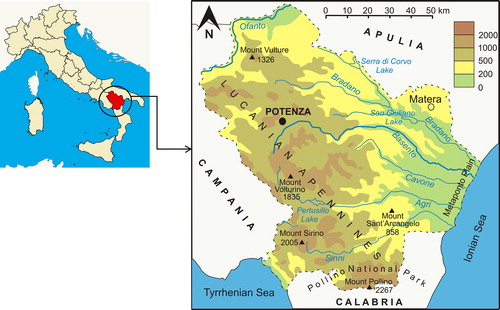
The territory is characterized mostly by mountains and hills, and by plains in a very little portion. In the southern part of the region, crossing the border with the Calabria region, the largest national park in Italy, the Pollino National Park, is present. Among the regional parks the ‘Murgia Materana’, that includes ancient evidences of the human prehistoric presence as well as the Rupestrian Churches, is worthy to be mentioned as it was inscribed in the UNESCO World Heritage Site together with the ‘Sassi of Matera’ (The Sassi and the Park of the Rupestrian Churches of Matera, https://whc.unesco.org/en/list/670, last access 27 June 2018). The Sassi represent the most ancient part of Matera town. They are surrounded by the Gravina stream flowing along the deep natural gorge that strongly marks out the local landscape. The Sassi symbolizes an extraordinary example of a rich historical stratigraphy. In point of fact, stable settlements have been documented in an important way and uninterruptedly on the top of Civita (the first inhabited nucleus) since the II millennium BC and they have grown along the right side of the Gravina stream whereon are still lying the two Sassi: Caveoso and Barisano (Gizzi et al. 2016).
Looking at the northern part of the region, the Pleistocene Vulture volcanic complex is present and, even it is not active, it constitutes a lively field for studies and an attractive touristic site for the presence of two volcanic lakes (Lago Grande and Lago Piccolo).
The plain portion of the region extends towards the south-east areas and the Ionian coast where, due also to the fertility of the soils crossed by the main rivers (Sinni, Agri, Basento, and Bradano rivers flowing into the Ionian sea), most of the agricultural activities are developed.
The orographic setup has influenced the natural vegetation cover accordingly, by crossing from forests, grasses, and pastures mostly located in mountains to less vegetated and dry areas in the central-eastern part of the region up to the Mediterranean scrub, in the coastal zones. In particular, the Pollino massif hosts a wide variety of natural vegetation which testifies the different climatic conditions affecting the territory. In this area, included in the homonymous National Park, the main feature of the natural vegetation is represented by the presence of Pinus leucodermis (from 800 up to 2,000 m above the sea level) which is a testimonial of a biological species which lives only in this portion of the territory.
As regards the human activities, the agriculture is developed mostly along the coastal zones, cultivated by orchards and cereals, and in the northern part where vineyards and olive groves are the dominant cultures in the volcanogenic Vulture basin. The vineyards in Basilicata cover about 4,021 ha, out of which 2,879 in Potenza province and 1,142 in Matera province (Schedario Viticolo – dati Citation2010), and have been recognized by important European and national acknowledgements due to their quality and production area.
By a geological point of view, Basilicata is part of the Southern Apennines which represent a NW-SE oriented segment of an arc-shaped thrust-and-fold belt (Gueguen et al. Citation1998). The geological history of the Southern Apennines is connected with the complex geodynamic evolution of the Mediterranean Sea, reflecting the interaction between the African and the European plates.
The main geologic features that can be identified in Basilicata are: (1) the Apennines stricto sensu, with silico and carbonatic deposits, evaporites, and ophiolitic deposits, Upper Jurassic -Cretaceous to Middle Pliocene; (2) the Bradanic Trough, to the east of the Apennine chain, with Lower Pliocene and Quaternary deposits (gravel, clay and sand); (3) the Apulia foreland with the Murgia Plateau whose western limits outcrop in Basilicata, mostly composed by carbonatic deposits, Lower Cretaceous to Upper Miocene.
Due to its geological features, Basilicata hosts the largest hydrocarbon reservoir in continental Europe, which has been studied since the beginning of the 20th century by many geologists and exploited by oil companies (Lazzari Citation2013).
Basilicata is one of the Italian regions most prone to hydrogeological instability, in which nearly 50% of the towns are classified as exposed at high risk of landslides or floods (e.g. Clarke and Rendell Citation2006; Di Maio et al. Citation2010; Lazzari Citation2011). The area affected by flood risk is 260 km2 wide (2.6% of the whole territory) and mainly includes the hilly areas and the coastal belt, which are exploited in agriculture, the main regional economic source (e.g. Piccarreta et al. Citation2013). Moreover, the nature of cropping terrains coupled with the climate dynamics have brought several inner areas to desertification, due to the widespread forms of land degradation (badlands) including rills, gullies, debris flows and loss of soil fertility (e.g. Piccarreta et al. Citation2006). This is probably due to the type of soil and to the deforestation, necessary to make room for pastures and the growing of cereals.
Besides this, the Basilicata region is considered to be a zone of moderate-high seismic activity. Presently, most of communes fall in medium and high seismic zones (http://zonesismiche.mi.ingv.it/class2004.html, last access, 21 May 2018). The seismic hazard of the region is well testified by numerous strong historical earthquakes (Rovida et al. Citation2016), the last of which occurred on 23 November 1980 (Mw 6.8), causing about 3000 deaths with very heavy damage to residential buildings, cultural heritage, productive, and industrial tissue. Furthermore, the seismic event also caused significant primary and secondary effects on the territory and environment (e.g. Esposito et al. Citation1998; Blumetti et al. Citation2002; Gizzi et al. Citation2012; Gizzi et al. Citation2014). Due to the hazard, studies have also been addressed to the management of the risk, so as to reduce the seismic vulnerability of buildings (e.g. Tilio et al. Citation2012).
From the demographic and socio-economic point of view, the Basilicata region is characterized by a very low population density—less than 55 inhabitants per km2 (http://noi-italia.istat.it/, last access on 27 June 2018)—, showing a sharp decrease in number of inhabitants in the last two decades. As for its industrial setting, Basilicata has a high percentage of micro-enterprises, higher than the national and southern region average, while the percentage of larger firms (between 10 and 19 employees) is slightly below the national average. Most of the micro-enterprises are individual firms whose business is linked to commerce and services. There are a few large international companies in the fields of oil and gas extraction activity (ENI, Total, and Shell), the automotive industry (FIAT) and agri-food (Ferrero and Barilla) (Regione Basilicata Citation2009).
Due to the human activities, the attention towards the environmental quality has been increased during the last decade with a particular focus on soil and air quality of the industrial areas located in Agri and Basento valleys, and Tito Scalo (Caggiano et al. Citation2005; Chianese et al. Citation2006).
With regard to the research and innovation system, Basilicata is characterized by numerous top-tier research centres, such as the University of Basilicata, some institutes of the National Research Council (CNR), the National Agency for New Technologies, Energy and Sustainable Economic Development (ENEA), the Centre for Space Geodesy (CGS) of the Italian Space Agency (ASI), and private consortia aimed at promoting R&D to SMEs.
3. Material and methods
In order to perform the bibliometric investigation, we taken the SCI-EXPANDED and SSCI citation indexes as a reference to extract the suitable articles (including items published as proceeding papers).
With the intention of pulling out the appropriate records from the two databases, we considered some terms to be used to search for topics (titles, abstracts, author keywords, and keyword plus) of the indexed articles. Numerous search terms were selected, spanning from the general words such as Basilicata and Lucania*, to the names of 131 communes (including the main hamlets) of the region, the name of the main rivers, mountains, lakes, and valleys. So as to avoid possible fake results, the abstracts of the articles resulted in the search output were manually analysed each time that a new search string was added to the previous.
The search query built with these terms has allowed to automatically extract the articles from the two databases. Despite the easiness of the approach, well consolidated in bibliometric studies, the fixed query could not be satisfactory as the articles that do not include geographically constraint terms in the topics (e.g. the name of the communes) would not have been caught by the query. In order to increase the chance of building as wide a dataset as possible, we considered additional terms to be included in the query, such as ‘south Italy’, ‘south of Italy’, ‘southern Italy’, and ‘southern Apennine*’. However, with the intention of identifying the articles targeting the Basilicata territory, the use of non-specific terms forced us to check by hand each article, analyzing the full-texts in a quick way. These indirect search criteria allowed to increase the dataset obtained by the automatic extraction by about 30%.
Once the records were selected from the two databases, they were downloaded (June 1, 2018) as plain text. The conventional analysis of the data, such as the publication trend and the subject categories, was made through the MS Excel software. As concerns the country co-authorship and the co-occurrence term networks they were performed through the VOSviewer software (version 1.6.8) that builds distance-based maps (www.vosviewer.com; Waltman et al. Citation2010). Details on this software will be given in the dedicate section (4.2.).
4. Results
4.1. Publication trend, subject categories, and countries
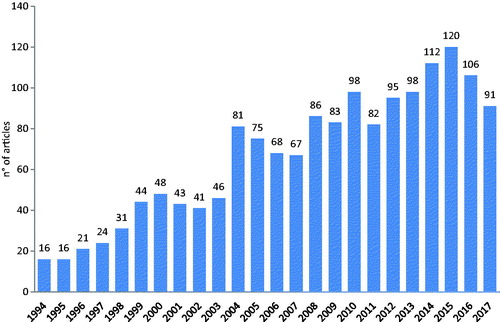
The total number of articles is 1,592. The mean yearly number is equal to about 66. The lowest number of articles was in 1994 (16), the highest in 2015 (120). Until 2003 the annual number of articles was less than 50 with a yearly average of 33. In 2004 the annual number of articles increased quite significantly, counting 81 items. Since 2008 the number of yearly items shows a general increase even if the fluctuations in the trend are not negligible ().
Figure 2. Yearly number of articles having the territory of the Basilicata region (or its portions) in the Topics (titles, abstracts, author keywords, and keyword plus).
The number of Web of Science categories is 115, in the whole reference period (1994–2017). The noteworthy number of categories involved depends on two main aspects: the first confirms the circumstance that Basilicata is an open-air laboratory, useful to attract scientists acting in different research areas; the second is due to the fact that journals where the articles are published can be assigned to multiple categories.
Multidisciplinary Geosciences was the most important category (541 records, 34.0% of the total), followed by Geochemistry and Geophysics (292, 18.3%), Physical Geography (225, 14.1%), and Water Resources (132, 8.3%). Twenty-four are the categories that include 20 articles at least ().
Table 1. Main Web of Science categories mirroring the content of the article database. The table shows the categories with 20 articles at least.
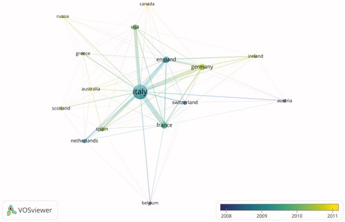
Researchers from fifty-nine countries all around the world authored or co-authored the articles. The most productive countries () were Italy, France, Germany, and England with more than 100 articles. The international collaboration network of the countries that signed at least 10 articles is shown in . In the figure, the nodes identify the countries, the size of nodes is proportional to the total number of articles from each country and the line thickness represents the cooperation link strength between two countries. By analyzing the network, it emerges that Italy collaborated with all top-productive countries (total link strength equal to 425) even if it had more cooperation with France (link strength equal to 88) and Germany (link strength equal to 69).
Figure 3. Countries that authored or co-authored the articles. For each country the number of articles is indicated. For the sake of readability, data for England, Scotland, Wales, and Northern Ireland are grouped as UK. Articles from Taiwan are grouped as China (see also ).
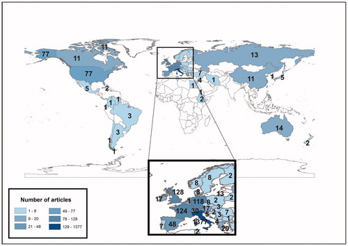
Figure 4. Overlay visualization of the co-authorship of the 16 countries that signed a number of articles equal to or greater than 10 (data on the productivity of all 59 countries are shown in ). The colours identify the average publication year of the articles for each country: we can infer that some countries (e.g. Canada and Russia) take a curtain call in more recent years.
4.2. Co-occurrence term maps and hot issues
The co-occurrence networks are used to give an image of possible relationships between words. In order to build the co-occurrence term map we used the VOSviewer software that considers the text mining technique to identify the noun phrases from titles and/or abstracts. After that, the noun phrases are classified on the basis of a relevance score: high relevance score is assigned when terms co-occurs mainly with a limited set of other noun phrases so showing a more specific meaning in the domain under investigation. In this way, noun phrases with low relevance score are those tend to be too general and meaningless for the domain of interest and therefore, excluded by the analysis. Therefore, VOSviewer grouped the high relevance noun phrases together into clusters to identify possible research topics or subfields. The default option of the software is to select 60% most relevant terms among the noun phrase that occurred 10 times at least (Van Eck and Waltman Citation2011; Van Eck and Waltman Citation2014).
The software produces three typologies of maps: network visualization, overlay visualization, and density visualization. The network visualization shows the items by their label and also by a circle. For each term, the size of the term label and the size of the term circle depends on the weight of the term. Furthermore, the colour of an item is determined by the cluster to which the item belongs. The overlay visualization is the same of the network visualization except that items are coloured in a different way, depending on the user choice. The density visualization highlights the density of an item or a cluster.
To build our co-occurrence term maps, we used the titles and abstracts to extract the noun phrases. After that, we built four co-occurrence maps: the first three maps, presented as network visualizations, concern the analysis over four 8 years long time windows: 1994–2001, 2002–2009, and 2010–2017. These maps make available information about the temporal changes of research fields, identifying their modifications over the years. The fourth map consists of the overlay visualization map regarding the whole time-span covered by this study (1994–2017), to give a general overview about the change of research fields over time.
From a methodological point of view, according to the previous experiences (e.g. Gizzi and Leucci Citation2018), in order to assure the building of maps and clusters having a number of terms suitable to represent the article content, the VOSviewer parameters such as the percentage of most relevant terms, the minimum number of term occurrence to be included in the map, and the cluster resolution were adjusted considering that the elaborations for earlier periods rely on a database made up of a fewer number of articles (). In order to select the significant terms, the option of inserting a thesaurus text file was considered to merge different spellings of the same term and different terms referring to the same concept. Furthermore, words considered too general and not relevant were deleted by hand. That being stated, we stress that the elaborations that will be discussed in the following sections must be considered as strictly correlated to the ‘threshold’ values adopted in the data elaboration ().
Table 2. VOSviewer parameters considered to build the co-occurrence maps (B = Blue; G = Green; R = Red; Y = Yellow; P = Purple).
According to what reported before, the diameter of a circle and the size of labels in the visualizations reflect the number of articles that have the corresponding term in their title or abstract. The terms that co-occur many times (that is the number of articles in which both words occur together is high) tend to be placed close to each other in the map, so that some clusters can be identified. Each of these is marked by some leading terms.
It must be underlined that in order to assure the ‘morphological’ comparison of the maps they were rotated and flipped horizontally and/or vertically. Furthermore, for the sake of readability the maps were graphically edited to add the keyword labels to some elements. Lastly, the visualization scale and the label size variation were adjusted for each map separately, so as the diameter of the circles cannot be used to quantitatively compare the term occurrences between the maps.
4.2.1. 1994–2001 co-occurrence map
The 1994–2001 map presents three main clusters. Adopting a simplified scheme, the first most populated (red) cluster can be associated to the Apennine geology (APG) studies, the second (green) group calls for climate (CLT) researches, the third (blue) bunch hosts articles on seismological aspects (SEISM) ().
Figure 5. Co-occurrence term network in 1994–2001 with the three main clusters of research (by VOSviewer, graphically modified).
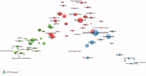
The APG and CLT clusters are of a comparable size (34 items against 30, respectively). The CLT cluster shows words where each of them is quite close to each other, so that one might infer that the field of research is already quite well structured. Density of terms decrease progressively from APG to SEISM cluster, the last showing the lowest number of terms (18).
The APG group, quite well connected with the SEISM group, can be identified by geological, geodynamic, seismotectonic, and geochemical studies of the Southern Apennines. One of the first work regards the structural analysis of the Pliocene-Quaternary terrigenous Sant'Arcangelo and Ofanto basin(s) [32 occurrences] and the study of the geometry of the sediment infill (Hippolyte et al. Citation1994). However, during the entire 8-years period, several works dealt with the investigation of the Lagonegro Basin [6]. In particular, these works are related to the analysis of the remanent magnetization of the Upper Triassic ‘Calcari con Selce’ limestone formation [22] the reconstruction of the tectonic history and the consequent evolution [30] of the Southern Apennine [57] chain, the identification of the basin-carbonate platforms relationship and the investigations about the contractional deformation [24] of the Basin itself (Gialanella et al. Citation1994; Marsella et al. Citation1995; Pescatore et al. Citation1999; Mazzoli et al. Citation2001). The Anzi-Calvello and Sant’Arcangelo basin(s) were also considered in the research. In detail, the tectonic evolution and the stratigraphic-sedimentary analyses were performed (Bonini and Sani Citation2000; Zavala Citation2000). The structure and the evolution of a segment of the Lucanian Apennines, extended from the Pollino to the Agri Valley and the evolution of the erosional landsurfaces of the Campanian-Lucanian Apennines were analysed by Monaco et al. (Citation1998) and Amato and Cinque (Citation1999), respectively. Furthermore, the analysis of the exploration data related to the oil fields in the Agri Valley allowed to analysed the deep structure [47] of the Campanian-Lucanian Arc (Noguera and Rea Citation2000).
In order to date the active faulting and constraint possible model [39] of earthquake sources of the Agri Valley, some studies considered the analysis of fault [27] properties by the acquisition of quantitative data aimed at assessing the structure permeability and the fractal properties of the faults (e.g. Cello Citation2000; Cello et al., Citation2000; Giano et al. Citation2000). The study of the horizontal strain [10] rate field from GPS data and site velocity [11] of the Central-Southern Apennines were also analysed by the researchers (e.g. Serpelloni et al. Citation2001). Further studies involved the analysis of historical and recent seismicity of the Potentino area allowing to identify at least four seismogenic zones (Alessio et al. Citation1995). Moving towards the boundary between the Basilicata and Calabria regions, geological studies considered the seismic potential of the Pollino fault. By paleoseismological trenches, Michetti et al. (Citation1997) identified traces of two historical earthquake(s) [6] with a magnitude 6.5–7.0 so as to infer that the seismic hazard of the area was higher than the Italian seismic catalogue suggested at that time. The Pollino was also one of three Italian areas considered in further research aimed at clarifying whether the Massif is a silent seismogenetic area or the documentary sources missed to record the earthquakes (Valensise and Guidoboni Citation2000).
Several studies also regarded the stress analysis by using borehole breakouts and focal mechanisms of the Southern Italy and the static stress changes imposed by 23 November 1980 earthquake in the Southern Apennines (e.g. Amato and Montone Citation1997; Nostro et al. Citation1997).
In the left-lower portion of the red cluster, close to the green cluster, we can identify a subgroup of terms related to the articles dealing with the chemical composition and the mineralogical–petrographical–physical properties of sample(s) [30], including xenolith garnet(s) [7], sampled at the undersaturated alkaline-potassic to ultrapotassic Mount Vulture strato-volcano rocks. These investigations were made also in view of drawing geodynamic, volcanological, and tectonic deductions (e.g. Marini et al. Citation1994; Melluso et al. Citation1996; Stoppa and Principe Citation1997; Peccerillo Citation1998; Jones et al. Citation2000; Rosatelli et al. Citation2000).
The CLT green cluster is mainly related to the paleoclimate studies performed on Monticchio lake records. The researchers identified environmental and climatic changes during the last glacial period, including the Dansgaard-Oeschger and Heinrich event(s) [6]. This was possible by the use of high-resolution sedimentological, microstratigraphical, geochemical, physical, radiocarbon, pollen, diatom, and plant macrofossil analyses performed on a large number of core samples of the lacustrine sequence (e.g. Watts et al. Citation1996a, Citation1996b; Zolitschka and Negendank 1996; Hajdas et al. Citation1997; Allen et al. Citation1999; Bindi et al. Citation1999; Huntley et al. Citation1999; Nimmergut et al. Citation1999; Ramrath et al. Citation1999; Allen et al. Citation2000). Also the use of geomagnetic records were considered as proxies of climate change until about 100 kyr BP (e.g. Creer and Morris Citation1996; Brandt et al. Citation1999).
The SEISM blue bunch, located at the right side of the map, mirrors studies that can be referred to the analysis of seismic precursors, considering the geoelectrical, seismoacoustic, geochemical and thermal fluctuation(s) [18] (e.g. Cuomo et al. Citation1998; Cuomo et al. Citation2000; Lapenna et al. Citation2000; Italiano et al. Citation2001; Telesca et al. Citation2001;Tramutoli et al. Citation2001).
4.2.2. 2002–2009 co-occurrence map
Analyzing the 2002–2009 map four main clusters can be identified (). The three clusters that were included in the map of the previous time period increased their significance, as we can argue from the number of terms and the word density in each of group. Furthermore, a new bunch of words (AGR-ENV-VEG-LAN) appears in the lower side of the map, identifying studies related to agriculture, environment, vegetation, and land that, however, taken individually do not reach the sizes to constitute independent clusters.
Figure 6. Co-occurrence term network in 2002–2009 with the four main clusters of research (by VOSviewer, graphically modified).
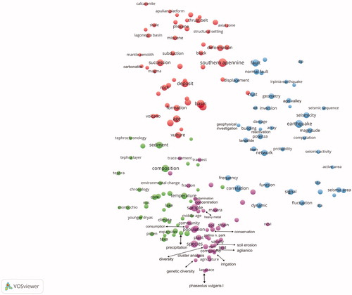
The APG (red) cluster confirms to be the largest cluster of the map (51 items). It gains more terms as respect to the previous time span showing a raise in differentiation of the studies regarding the Southern Apennines. Among the new terms, in the upper-left side of the cluster, shale [11] subtends some geochemistry studies useful, for example, to understand the genesis and the paleoenvironment of shales having different ages (e.g. Di Leo et al. Citation2002; Cavalcante et al. Citation2003). Also the structural setting [10] (upper-right side) seems to be an emerging term, so as such features of the thrust belt [29] or Mount Vulture [36] Volcano were also considered (e.g. Bentivenga et al. Citation2005; Fedi et al. Citation2005; Piedilato and Prosser Citation2005; Schiattarella et al. Citation2005).
Moving the attention to the central-left side of the cluster, mantle xenolith [6] and carbonatite [9] emerge, pointing out that they can be referred to petrographic and geochemistry studies on Vulture rocks with consequent interpretations also in geodynamic (subduction [15]) perspective (e.g. Downes et al. Citation2002; D'Orazio et al. Citation2007).
The other clusters of the map show a comparable size. The new (2nd) purple group, that counts 44 items, shows words that we can further subdivide into some sub-clusters, such as agriculture-food, environmental, vegetation, and land studies (AGR-ENV-VEG-LAN). As a matter of fact, in the lower part of the cluster we find the terms that mainly reproduce the agricultural-food studies. We refer, for example, to the analyses of the red Aglianico [8] wine [13] and those studies related to the scrutiny of aspects linked to the fermentation processes, the compositional causes of the sweet-like off-flavour or the analysis about the effects of heat and/or light on the composition of some volatile compounds (e.g., Romano et al. Citation2003; Lechiancole et al. Citation2006; Tat et al. Citation2007; Cellamare et al. Citation2009; D’Auria et al. Citation2009). Other studies consider the use of spectroscopic techniques to differentiating the Italian wines produced in different regions, comparing the Aglianico wines from Basilicata with those of the neighbouring Campania region (Viggiani and Castiglione Morelli Citation2008). The necessity of the viticulture zoning of the ‘Aglianico del Vulture’ was the subject of further research (Caputo et al. Citation2006).
Research in agriculture include the investigation about biological features, nutritional quality, and antioxidant activity of the common bean (Phaseolus vulgaris L. [7]) landraces [6] (e.g., Piergiovanni and Pignone Citation2003; Heimler et al. Citation2005; Lioi et al. Citation2005). Also the irrigation [9] was a matter to be considered in agriculture by the analysis of the role that can be played by wastewater (e.g. Lopez et al. Citation2006; Palese et al. Citation2009), or the impact of irrigation on cultivations (e.g. Metzidakis et al. Citation2008; Favati et al. Citation2009) and the usefulness of irrigation to mitigate desertification process avoiding the loss of soil productivity (Costantini et al. Citation2009).
In the central-lower part of the cluster we can identify terms that call for vegetation studies. These terms exceed the boundary of the group, as shown by the interpenetration between the purple and green clusters. Pollino National Park [10] was the subject of studies regarding the investigations on structure, environment relationship, biological features of plant [26], and animal populations (e.g. Mura Citation2004; Pandolfi et al. Citation2004; Bellusci et al. Citation2005; Gargano and Bernardo Citation2006).
At the right side of the cluster we find, in a quite isolated position, the word ndvi [8] (Normalized Difference Vegetation Index). As we can see, the word is very close to the blue cluster, so showing a relationship with some of these terms. Really, the connection with the blue cluster is due to the link with detection [14], algorithm [19] and dfa [8] (detrended fluctuation analysis) method, this last was also adopted to examine the seismic precursor data. The Normalized Difference Vegetation Index was used to detect archaeological crop marks and archaeological buried remains (Lasaponara and Masini Citation2006, Citation2007), analyse vegetation [22] phenology, land [11] degradation (e.g. Bonfiglio et al. Citation2002; Lanfredi et al. Citation2003), and fire susceptibility (Lasaponara Citation2005).
As concerns the ENV subgroup, in the upper portion of the bunch, several studies concern the presence and/or the source origin of heavy metal(s) [8] in marine sediments (e.g. Buccolieri et al. Citation2004, Citation2006), atmosphere (e.g. Ragosta et al. Citation2002, Citation2006, Citation2008), soil (e.g. Chianese et al. Citation2006), and plant or animal species (e.g. Caggiano et al. Citation2005; Santoro et al. Citation2009).
Towards the left side of the cluster, we find the join of terms that ‘simulate’ the climate studies (CLT). The green group, that counts 40 terms (4th), shows some new terms such as Younger Dryas [8]. The term indicates one of the most well known examples of abrupt climate change during the shift from the last cold glacial stage to a warmer interglacial state. During this transition, temperatures in the Northern Hemisphere suddenly returned to the near-glacial conditions. This near-glacial period is called Younger Dryas from the flower Dryas octopetala that was common in Europe during this phase. Studies about the Younger Dryas in the sediments of Lago Grande di Monticchio were performed by pollen [12] investigations so showing that there was no evidences at Monticchio of a Younger Dryas-like oscillation during the penultimate deglaciation (e.g. Brauer et al. Citation2007; Allen and Huntley Citation2009). The cluster also refers to articles having the changes in temperature(s) [39] and precipitation(s) [12] during historical times as a focus, also analyzing their consequences (e.g. Lucarini et al. Citation2004; Piccarreta et al. Citation2004; Piccarreta et al. Citation2006; Toreti and Desiato Citation2008).
Observing the map, at the antipode of the green cluster, we find the 3rd cluster (SEISM-MLD) that by 43 terms mirrors the seismological studies and other research fields that do not reach the size useful to build independent clusters. Therefore, the cluster that in the previous time period incorporated seismological (SEISM) studies expands, including also specific seismotectonic investigations (at the border with the APG red cluster) and other research fields that for the sake of brevity we can classify as multidisciplinary (MLD).
At the right-lower side, a number of terms can be referred to investigations on earthquake precursors with special attention to the geoelectrical and natural electromagnetic signals recorded in the seismic areas of Giuliano and Agri Valley analysed by means of the multifractal detrended fluctuation analysis (MF-DFA [8]) (e.g. Telesca et al. Citation2004; Balasco et al. Citation2007). These articles are in line with similar studies referred to the earthquake ‘cluster’ of the 1994–2001 time span. In the central-lower part of the bunch, other terms such as network, seismicity call for the study of data recorded from seismic networks to investigate the wave attenuation in the Southern Apennines (e.g. Bianco et al. Citation2002; Castro et al. Citation2004), infer seismotectonic aspects in the Lucanian Apennines and foredeep (e.g. Frepoli et al. Citation2005; Brozzetti et al. Citation2009; Maggi et al. Citation2009), and analyse the temporal and/or spatial relations between seismicity and human activity in Agri Valley (e.g. Valoroso et al. Citation2009). Furthermore, towards the end of the 2002–2009 period, the ISNet seismic network was in advanced phase of completion. The system was designed to provide real-time or near real-time earthquake alert notification for early-warning applications and post-event rapid evaluation of ground-shaking maps (Weber et al. Citation2007). Other studies refer to 1930 and 1980 Irpinia earthquake(s) [11]. As regards the 1930 earthquake, the articles involve both investigations aimed at clarifying the features of the seismic sources by the use of historical waveforms (Pino et al. Citation2008) and the analysis of damage effects caused by the earthquake in some urban areas, among which Potenza (Gizzi and Masini Citation2007). Considering the 1980 Irpinia seismic event, studies face the analysis of the fault structure, the faulting geometry, the coseismic displacement or the combined analysis of some geophysical, geochemical, and hydrogeological anomalies recorded around the time of the seismic event (Armigliato and Tinti Citation2003; Improta et al. Citation2003; Amoruso et al. Citation2005; Pulinets et al. Citation2007). For both these two events systematic analysis and cataloguing of the environmental effects such as surface faults, ground cracks, slope failures, and liquefactions were performed by, for example, Porfido et al. (Citation2007). The area affected by the 1857 Basilicata earthquake, that struck the Agri Valley [18] and the Diano Valley was also analysed considering, for example, the potential seismogenetic source (e.g. Cello et al. Citation2003; Burrato and Valensise Citation2008) and the site amplification effects (e.g. Gallipoli et al. Citation2003).
In the central-left portion of the cluster, the term building [18] is correlated with earthquake [76] (link strength-LS-equal to 7), damage (LS = 5) [12], and frequency (LS = 3) so showing that the group of terms calls for seismic risk analysis and earthquake engineering studies such as the earthquake loss scenarios (e.g. Dolce et al. Citation2006) or the analysis of fundamental frequencies and damping for buildings in Potenza (Gallipoli et al. Citation2009). Other studies regard the seismic behaviour of base-isolated buildings (e.g. Braga and Laterza Citation2004; Cardone et al. Citation2006) and the investigation about the soil-structure interaction (e.g. Mucciarelli et al. Citation2003; Gallipoli et al. Citation2004). Close to these terms, we can also note landslide [20]. Other terms of the area close to landslide are, for example, geophysical investigation [8], electrical resistivity tomography [11], reactivation [6], and damage [12]. The articles that subtend two or more of these words indicate that geomorphological, geophysical, numerical, topographical, historical-documentary, and dendrochronological methods or techniques as well as approaches based on the artificial intelligence were considered to investigate, monitor the landslides, and manage the hazard in urban areas as well as in cultural heritage sites (e.g. Rizzo Citation2002; Troncone Citation2005; Perrone et al. Citation2004; Caniani et al. Citation2008; Gizzi Citation2008; Guida et al. Citation2008, Naudet et al. Citation2008).
4.2.3. 2010–2017 co-occurrence map and synoptic temporal pattern
The 2010–2017 map shows five main clusters, one more than in the previous time span (). The new yellow cluster concerns the tephrochronology/tephrostratigraphy studies (TEPH).
Figure 7. Co-occurrence term network in 2010–2017 with the five main clusters of research (by VOSviewer, graphically modified).
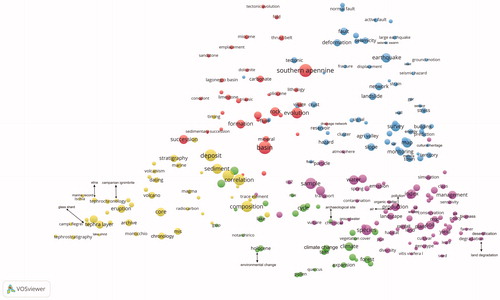
The 1st most populated cluster (purple) is made up of 80 terms and it can be thought of as subdivided in three sub-clusters (AGR-LAN-ENV). In the lower part of the bunch we can identify the sub-group related to the agriculture(-food) studies (AGR) whose words trace the prosecution of the research on both Aglianico Vitis vinifera [new term, with 7 occurrences] and wine from it derived. Several aspects are investigated, such as the ampelographic and pedigree features of the Vitis as well as the nutraceutical properties of the wine (e.g. Alba et al. Citation2011; De Lorenzis et al. Citation2013; De Nisco et al. Citation2013). The agriculture sub-cluster also considers the irrigation issues in relationship with the cultivations and yield(s) [new term, 40] (e.g. Katerji et al. Citation2010; Palese et al. Citation2010; Candido et al. Citation2015).
The central-right side of the cluster refers to the sub-group whose words trace the land as subject (LAN). Some articles deal with land degradation [10], desertification [new, 11], and management [52] issues (e.g. Salvati et al. Citation2011; Basso et al. Citation2012; Salvati et al. Citation2013; Kelly et al. Citation2015). Other words consider the urban sprawl issue for different localities of the Basilicata region (e.g. Amato et al. Citation2015; Di Palma et al. Citation2016).
In the upper-left side of the cluster, it is possible to identify words that trace the environmental studies (ENV). We refer to the research in pollution [new, 16] of river sediment due to metals (e.g. Medici et al. Citation2011), soil pollution in industrial areas (e.g. D’Emilio et al. Citation2010), air pollution (e.g. Caggiano et al. Citation2011; Pavese et al. Citation2012; Trippetta et al. Citation2014), groundwater [new, 10] (and) contamination [10] due to dumpsites (e.g. Caniani et al. Citation2015). Further investigations regarded the dispersion and pollution caused by asbestos fibres (e.g. Beneduce et al. Citation2012) and the pollution of soil and groundwater due to agricultural chemicals and pathogens (e.g. Coppola et al. Citation2014).
Adjacent to the AGR-LAN-ENV cluster we find the 2nd blue cluster (62 items, SEISM-MLD) that growths in complexity as respect to the previous time span.
In the upper part, where seismological studies emerge (SEISM), the investigations on seismic precursors disappear and some new terms including seismic hazard [11], seismic swarm [7], and isnet [ISNet, 9] catch the eye. The acronym ISNet indicates the Irpinia Seismic Network, planned to estimate in real-time the epicentre and magnitude, provide ground-motion parameters, assess the ground shaking expected and study the seismogenetic faults in the Southern Apennines. The network and its technological features as well as the analysis of data recorded from the network were the subject of numerous articles in the 2010–2017 time span (e.g. Emolo et al. Citation2011; Satriano et al. Citation2011; Vassallo et al. Citation2012). Another new term of the cluster is reservoir [27] (lower-left area) that joined with seismicity [32] calls for the research about the induced seismicity caused by wastewater re-injection (e.g. Improta et al. Citation2015; Buttinelli et al. Citation2016) or annual fluctuations of water level in the Pertusillo artificial lake reservoir of Agri Valley (e.g. Stabile et al. Citation2015).
In the central-lower part of the cluster the MLD studies start, among which physical geography studies, engineering field-related investigations, and cultural heritage researches.
Close to reservoir we can also find drainage network [new, 8] that considered jointly with landslide [42] subtends studies regarding the relationships between landslide occurrence and drainage network (e.g. Santangelo et al. Citation2013).
The lower part of the cluster shows other new terms such as SAR [13, new] (Synthetic Aperture Radar) sensor(s) [new, 10] that was considered to study the Montescaglioso landslide (Raspini et al. Citation2015). SAR, jointly with other techniques, was also taken as a tool for the monitoring [42] of the Musumeci bridge in Potenza chief-town (Proto et al. Citation2010; Catapano et al. Citation2012; Fornaro et al. Citation2013; Stabile et al. Citation2013), the investigating of archaeological site(s) [14] (e.g. Chen et al. Citation2015), and the analysis of flood(s) [new, 10] (e.g. D'Addabbo et al. Citation2016). As regards this last, the use of flood maps allowed to identify the flood-prone areas over the Bradano River basin (Manfreda et al. Citation2015).
The term energy calls for energy performance analysis of Matera public and historical building(s) [27] (e.g. Cardinale et al. Citation2013; Rospi et al. Citation2017). However, the term energy [22] is also related to the adjacent purple cluster. This can be argued analysing some articles that deal with the energy consumption in relationship to the agricultural crop(s) [new, 29] (e.g. Cozzi et al. Citation2015; Pergola et al. Citation2017) or availability of biomass [new, 14] (Delivand et al. Citation2015) (right part of the purple cluster).
Cultural heritage [new, 8] is another new compound term that emerges in the lower-right side of the blue cluster. Cultural heritage calls for studies performed on Matera UNESCO site, considering the monitoring approach based on the ICT technology (Gribaudo et al. Citation2017), the conservation state of wall(s) [12] of monuments or building(s) of the Sassi of Matera (e.g. Danese et al. Citation2010; Gizzi et al. 2016). Other research in the cultural heritage field consider the use of the in situ survey(s) [63] for monitoring the heritage by means of gpr [new, 7] (ground-penetrating radar) or low cost technologies (e.g. Masini et al. Citation2010; Sileo et al. Citation2017). Furthermore, the analysis of slope [46] processes and hazard [new, 26] of archaeological site(s) [14] was also considered (e.g. Lazzari and Gioia Citation2017).
The closeness of the MLD sub-cluster to the SEISM-related research (upper portion) is due to multiple factors such as the cause–effect relationship between earthquakes and landslides, the circumstance that these natural hazards can cause damage to building(s) or cultural heritage. Other reason is the sharing of some approaches, methods, and survey techniques to investigate on landslides, earthquakes, and buildings, such as the hazard analysis, the monitoring, the mapping, the use of geophysical survey techniques such as gpr.
The emerging yellow cluster (3rd, TEPH) of tephrocronology-tephrostratigraphy studies is made up of 49 terms.
In the northern part of Basilicata, archaeological and volcanic studies were performed by intertwining and overlapping each other towards important discovers dealing with evidences of the Early Acheulian culture in Western Europe as the oldest Middle Pleistocene human fossil discovered in Italy so far, found and dated in tephra [48] at Notarchirico site, in the Venosa basin (Lefèvre et al. Citation2010). The tephra examined in this area were well preserved in the medium-sized maar lake ‘Lago Grande di Monticchio’, occupying a crater of Mount Vulture. The sediment sequence of the Monticchio lake represents one of the most relevant archive since it provides both eruptive evidence from adjacent volcanic centres and robust chronologies. Here, geochemical, tephrostratigraphy, and chronology studies have been carried out during 2010–2017, by allowing to reconstruct the eruptive history of Vulture and other Italian volcanoes during the late Quaternary, and the physical link to other Holocene archives located in the Central and Eastern Mediterranean (e.g. Lake Ohrid [7]). The chronology of the sediments in Monticchio lake has allowed to provide paleoclimatic records back to 133ka BP, the end of the penultimate Glacial (Wulf et al. Citation2012). The transition from stadial to interstadial conditions at Monticchio is well documented by the distinct lithological changes in the sediments, and this natural archive has contributed to understand the effects caused by the Heinrich stadial H4 and the correlations recorded also in the Eastern Mediterranean area. In this framework, the correlation between the Campanian Ignimbrite tephra layer and the 40–38 ka varved sediments was studied allowing to elaborate considerations on the existence or absence of correlation between the onset of a millennial-scale cold stadial H4 and the occurrence of the Campanian Ignimbrite [9] eruption (Wutke et al. Citation2015). In the Monticchio lake the distal tephra fallout layers from volcanic sources in Central and Southern Italy, which are located between 100 and 540 km away, were indeed found such as from the Campanian Ignimbrite (Campi Flegrei [9]), Monte Epomeo Green Tuff (Ischia Island [7]), and Alban Hills (Roman Province).
The 4th red APG cluster is made up of 36 items. Among the new terms, conodont [new, 10] (lower-left part of the cluster) identifies the use of the minute tooth-like fossil as biostratigraphical constraints of the Lagonegro basin [14] succession at different sites (e.g. Giordano et al. Citation2010). Further studies regard, for example, the investigation of sedimentary and/or tectonic [31] aspects of geological formations or morphological units (Cavalcante et al. Citation2015; Sinisi et al. Citation2016; La Bruna et al. Citation2017).
The 5th green cluster, linked to the yellow one, is made up of 30 items. It has the least number of words and it is mainly related to terms focusing on both paleo/recent climate-environment change and vegetation studies (CLT-VEG).
Many studies consider the pollen [19] records of Lago Grande di Monticchio to perform paleoclimate comparisons and correlations between different sites at national or international scale for the last glacial and interglacial stages (Pini et al. Citation2010; Bogotá et al. Citation2011; Joannin et al. Citation2012; Pickarski et al. Citation2015). As a matter of fact, the sediments of Lago Grande di Monticchio have been cored since 1982 and the relative pollen record are very well-documented (e.g. Watts, Citation1985; Allen and Huntley Citation2009). Other studies refer to a series of investigations about the paleoenvironment changes and climate patterns of specific marine successions (e.g. Marino et al. Citation2015).
Climate [59] analysis of data recorded over the last decades was also performed at regional and local scale in Basilicata to investigate different aspects such as the changes in precipitation and the Urban Heat Island phenomenon (e.g. Longobardi et al. Citation2016; Giorgio et al. Citation2017).
The other group of terms can be identified with different studies such as those on plant physiology or related to the relationship between changes in vegetation and natural/human conditioning factors (e.g. Paletto et al. Citation2014; Rita et al. Citation2014; Colangelo et al. Citation2017; Giarrizzo et al. Citation2017). This group of terms is connected with the left side of the (AGR-LAN-ENV) purple cluster.
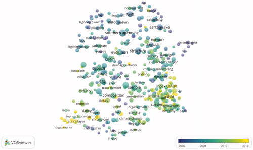
To illustrate the evolution of research areas over time we can also show the terms analysis of the publications, but with time information. To this purpose, shows a co-occurrence term map based on titles and abstracts of the articles in the period 1994–2017. The colour of a term in the overlay visualization indicates the average publication year of the articles in which the term occurs. Terms occurring in recent articles are coloured green and yellow. These terms can be found mainly in the lower part of the overlay visualization where agriculture-food, land, environmental, and vegetation studies (lower-right area of the map), and the tephrochronology-tephrostratigraphy investigations (lower-left) can be identified as ‘new’ research fields. On the contrary, the lower average publication year (blue colour) is related to some ‘mature’ research fields such as the Apennine geology studies and seismological investigations (central-upper part of the map).
Figure 8. Co-occurrence term in overlay visualization (1994–2017). The overlay colour of each circle corresponds to the average publication year of all the articles that include the corresponding word. In this map, the terms with the blue colour represent the research activities with older average publication year and the terms with the yellow colour show the terms with more recent average publication year.
Conclusion
The article has considered the bibliometric analysis of the research outputs concerning the Basilicata region during the 1994–2017 time span. Two databases were considered: the Thomson Reuters’ Science Citation Index Expanded (SCI-EXPANDED) and the Social Sciences Citation Index (SSCI) accessed via the Web of Science Core Collection.
The total number of articles was 1,592 and the number of Web of Science categories involved was 115. Fifty-nine countries all around the world authored or co-authored the articles. Italy, France, Germany, and England were the most productive countries and Italy had collaboration with all top-productive countries, in particular with France and Germany.
The number and the complexity of the research fields increased progressively over time. The first part of the time span investigated has shown the development of three main research fields regarding the Apennine geology, the paleoclimate, and the seismology. The period from 2002 to 2009 was characterized by the ‘entry’ of agriculture, environment, vegetation, and land studies with a growth in diversification of those researches that marked out the second half of the nineties of the last century. Furthermore, the studies of the first decade of 2000s include landslide-flood investigations and other engineering-related and cultural heritage researches. From 2010 until 2017 a well-defined cluster of tephrocronology/tephrostratigraphy studies emerge with a significant increase in diversification of the agriculture/land/environment studies.
The relatively recent age of the agriculture-food/land/environment studies and the progressive evolution of these researches over the last 16 years in Basilicata might be considered a clue that these investigations, taken on the whole, will also significantly engage the scientific community in the next years. Quite similar considerations can be made for the group of earthquake-related studies/hydrogeological instability investigations/cultural heritage researches (SEISM-MLD in the maps). These bibliometric remarks can be strengthen by considering the policy that is going to be accomplished in the Region according to the European Commission for programming 2014-2020. Really, the European Commission requested to all the European regions, as a mandatory requirement for the application of the European Regional Development Fund (ERDF) Operational Program 2014-2020, to adopt the Research and Innovation Smart Specialization Strategy (RIS3) (EU Regulation no. 1303/2013). RIS3 of Basilicata has identified five priorities, among which there are bio-economy (including agri-food), earth observation, and cultural heritage (http://www.pofesr.basilicata.it/fesr2014-20/?page_id=60). On these priorities, the European Regional Development Fund (ERDF) Operational Program 2014-2020 of Basilicata has allocated more than 800 million Eur, most of them to be addressed to the implementation of experimental research and development projects in each priority of RIS3 (http://europa.basilicata.it/fesr/programma/piano-finanziario/).
From the outlook angle, the outcomes of this study can supply a support to scientists that are approaching in some research areas having the territory of the Basilicata region as focus. Furthermore, also due to the presence of numerous and different skilled top-tier research centres within the region, the results summarized in this article can encourage the scientific community to start new research activities by the building of interdisciplinary and transdisciplinary networks of scientists so as to further uphold the international competitiveness of research projects.
However, the readers have to be attentive to the results of this study that, likewise all bibliometric studies, have some constraints. Firstly, the unfeasibility to prepare all-inclusive search queries to search for articles might have left out some relevant articles. In addition, all the findings and discussions included here have to be strictly considered as a result of the content analysis of the two ISI databases taken as a reference that do not index some journals, so that some articles published are out of the investigations performed here. Lastly, the article supplies an overview of the main research fields related to the territory of Basilicata. In order to gain more clues and perform specific analysis, more thorough studies for each research activity are requested.
Captions.docx
Download MS Word (12.1 KB)Acknowledgements
The authors wish to thank two anonymous reviewers for their valuable comments and suggestions that allowed us to improve the overall quality of the article.
Disclosure Statement
No potential conflict of interest was reported by the author(s).
Related Research Data
References
- Alba V, Anaclerio A, Gasparro M, Caputo AR, Montemurro C, Blanco A, Antonacci D. 2011. Ampelographic and molecular characterization of Aglianico accessions (Vitisvinifera L.) collected in Southern-Italy. S Afr J Enol Viticult. 32(2):164–173.
- Alessio G, Esposito E, Gorini A, Porfido S. 1995. Detailed study of the Potentino seismic zone in Southern Apennines, Italy. Tectonophysics. 250(1-3):113–134.
- Allen JRM, Brandt U, Brauer A, Hubberten H-W, Huntley B, Keller J, Kraml M, Mackensen A, Mingram J, Negendank JFW. 1999. Rapid environmental changes in southern Europe during the last glacial period. Nature. 400(6746):740–743.
- Allen JRM, Huntley B. 2009. Last interglacial palaeovegetation, palaeoenvironments and chronology: a new record from Lago Grande di Monticchio, southern Italy. Quat Sci Rev. 28(15-16):1521–1538.
- Allen JRM, Watts WA, Huntley B. 2000. Weichselian palynostratigraphy, palaeovegetation and palaeoenvironment: the record from Lago Grande di Monticchio, Southern Italy. Quat. Int. 73-74:91–110.
- Amato A, Cinque A. 1999. Erosional landsurfaces of the Campano‐Lucano Apennines (S. Italy); Genesis, evolution, and tectonic implications. Tectonophysics. 315(1-4):251–267.
- Amato A, Montone P. 1997. Present-day stress field and active tectonics in southern peninsular Italy. Geophys J Int. 130(2):519–534.
- Amato F, Pontrandolfi P, Murgante B. 2015. Supporting planning activities with the assessment and the prediction of urban sprawl using spatiotemporal analysis. Ecol. Inf. 30:365–378.
- Amoruso A, Crescentini L, Scarpa R. 2005. Faulting geometry for the complex 1980 Campania-Lucania earthquake from levelling data. Geophys J Int. 162(1):156–168.
- Armigliato A, Tinti S. 2003. Influence of topography on coseismic displacements induced by the Friuli 1976 and the Irpinia 1980 earthquakes (Italy) analyzed through a two-dimensional hybrid model. J Geophys Res. 108(B12).
- Balasco M, Lapenna V, Romano G, Siniscalchi A, Telesca L. 2007. Extracting qualitative dynamics in earth's apparent resistivity time series by using the detrended fluctuation analysis. Physica A. 374(1):380–388.
- Basso B, De Simone L, Cammarano D, Martin EC, Margiotta S, Grace PR, Yeh ML, Chou TY. 2012. Evaluating responses to land degradation mitigation measures in Southern Italy. Int J Environ Res. 6(2):367–380.
- Bellusci F, Pellegrino G, Palermo AM, Gargano D, Musacchio A. 2005. Genetic differentiation of the endemic orophyte Campanula pollinensis along an altitudinal gradient. PlantBiosyst. 139(3):349–356.
- Beneduce P, Di Leo P, Giano SI, Schiattarella M. 2012. Quantitative geomorphic analysis of asbestos dispersion and pollution from natural sources: the case-history of the Pollino National Park, southern Italy. Geogr Fis Din Quat. 35:3–12.
- Bentivenga M, Foresi ML, Prestera A, Prosser G, Sabia M. 2005. Structural setting at the front of a thrust and fold belt: the Craco area (Southern Apennines, Italy). Bol Soc Geol It. 124:367–376.
- Bianco F, Del Pezzo E, Castellano M, Ibanez JM, Di Luccio F. 2002. Separation of intrinsic and scattering seismic attenuation in the southern Apennine zone, Italy. Geophys J Int. 150(1):10–22.
- Bindi L, Cellai D, Melluso L, Conticelli S, Morra V, Menchetti S. 1999. Crystal chemistry of clinopyroxene from alkaline undersaturated rocks of the Monte Vulture Volcano, Italy. Lithos. 46(2):259–274.
- Blumetti AM, Esposito E, Ferreli L, Michetti AM, Porfido S, Serva L, Vittori E. 2002. Ground effects of the 1980 Irpinia earthquake revisited: evidence for surface faulting near Muro Lucano. In: Dramis F, Farabollini P, Molin P, editors. Large-scale vertical movements and related gravitational processes, Studi Geol Camerti; Int. Workshop Camerino-Rome, June 21–26, p. 19–27.
- Bogotá RG, Groot MHM, Hooghiemstra H, Lourens LJ, Van der Linden M, Berrio JC. 2011. Rapid climate change from north Andean Lake Fúquene pollen records driven by obliquity: implications for a basin-wide biostratigraphic zonation. Quat Sci Rev. 30(23-24):3321–3337.
- Bonfiglio A, Cuomo V, Lanfredi M, Macchiato M. 2002. Interfacing NOAA/ANHRR NDVI and soil truth maps for monitoring vegetation phenology at a local scale in a heterogeneous landscape of Southern Italy. Int J Remote Sens. 23(20):4181–4195.
- Bonini M, Sani F. 2000. Pliocene–Quaternary transpressional evolution of the Anzi–Calvello and Northern S. Arcangelo basins (Basilicata, Southern Apennines, Italy) as a consequence of deep-seated fault reactivation. Mar Pet Geol. 17(8):909–927.
- Braga F, Laterza M. 2004. Field testing of low-rise base isolated building. Eng. Struct. 26(11):1599–1610.
- Brandt U, Nowaczyk NR, Ramrath A, Brauer A, Mingram J, Wulf S, Negendank JFW. 1999. Palaeomagnetism of holocene and late pleistocene sediments from Lago di Mezzano and Lago Grande di Monticchio (Italy): initial results. Quat Sci Rev. 18(7):961–976.
- Brauer A, Allen JRM, Mingram J, Dulski P, Wulf S, Huntley B. 2007. Evidence for last interglacial chronology and environmental change from southern Europe. Proc Natl Acad Sci USA. 104(2):450–455.
- Brozzetti F, Lavecchia G, Mancini G, Milana G, Cardinali M. 2009. Analysis of the 9 September 1998 Mw 5.6 Mercure earthquake sequence (Southern Apennines, Italy): a multidisciplinary approach. Tectonophysics. 476(1-2):210–225.
- Buccolieri A, Buccolieri G, Cardellicchio N, Dell'Atti A, Di Leo A, Maci A, Petronio BM. 2004. Distribution and speciation of metals in surface sediments of Taranto [corrected] gulf (Ionian Sea, Southern Italy)). Ann Chim. 94(7-8):469–478.
- Buccolieri A, Buccolieri G, Cardellicchio N, Dell'Atti A, Di Leo A, Maci A. 2006. Heavy metals in marine sediments of Taranto Gulf (Ionian Sea, Southern Italy). Mar Chem. 99(1-4):227–235.
- Burrato P, Valensise G. 2008. Rise and fall of a hypothesized seismic gap: source complexity in the Mw 7.0 16 December 1857 Southern Italy Earthquake. Bull Seism Soc Am. 98(1):139–148.
- Buttinelli M, Improta L, Bagh S, Chiarabba C. 2016. Inversion of inherited thrusts by wastewater injection induced seismicity at the Val d’Agri oilfield (Italy). Sci Reports. 6:37165.
- Caggiano R, D’Emilio M, Macchiato M, Ragosta M. 2005. Heavy metals in ryegrass species versus metal concentrations in atmospheric particulate measured in an industrial area of southern Italy. Environ Monit Assess. 102(1-3):67–84.
- Caggiano R, Fiore S, Lettino A, Macchiato M, Sabia S, Trippetta S. 2011. PM2.5 measurements in a Mediterranean site: two typical cases. Atmos Res. 102(1-2):157–166.
- Candido V, Campanelli G, D’Addabbo T, Castronuovo D, Perniola M, Camele I. 2015. Growth and yield promoting effect of artificial mycorrhization on field tomato at different irrigation regimes. Sci Hort. 187:35–43.
- Caniani D, Lioi DS, Mancini IM, Masi S. 2015. Hierarchical classification of groundwater pollution risk of contaminated sites using fuzzy logic: a case study in the Basilicata Region (Italy). Water. 7(12):2013–2036.
- Caniani D, Pascale S, Sdao F, Sole A. 2008. Neural networks and landslide susceptibility: a case study of the urban area of Potenza. Nat Hazards. 45(1):55–72.
- Caputo R, Fiore A, Nuzzo V. 2006. Preliminary results of viticultural zoning of the DOC Aglianico del Vulture production area. Boll Soc Geol Ital. 6:161–167.
- Cardinale N, Rospi G, Stefanizzi P. 2013. Energy and microclimatic performance of Mediterranean vernacular buildings: The Sassi district of Matera and the Trulli district of Alberobello. Build Environ. 59:590–598.
- Cardone D, Dolce M, Ponzo FC. 2006. The behavior of SMA isolation systems based on a full-scale release test. J Earthq Eng. 10(6):815–842.
- Castro RR, Gallipoli MR, Mucciarelli M. 2004. An attenuation study in southern Italy using local and regional earthquakes recorded by seismic network on Basilicata. Ann Geophys. 47(5):1597–1608.
- Catapano I, Crocco L, Morabito AF, Soldovieri F. 2012. Tomographic imaging of holographic GPR data for non-invasive structural assessment: the Musmeci bridge investigation. Nondestruct Test Eval. 27(3):229–237.
- Cavalcante F, Fiore S, Piccarreta G, Tateo F. 2003. Geochemical and mineralogical approaches to assessing provenance and deposition of shales: a case study. Clay Miner. 38(03):383–397.
- Cavalcante F, Prosser G, Agosta F, Belviso C, Corrado G. 2015. Post-depositional history of the Miocene Gorgoglione Formation (southern Apennines, Italy): inferences from mineralogical and structural analyses. Bull Soc Geol Fr. 186: 243–256.
- Cellamare L, D’Auria M, Emanuele L, Racioppi R. 2009. The effect of light on the composition of some volatile compounds in wine: an HS-SPME-GC-MS study. Int J Food Sci Technol. 44(12):2377–2384.
- Cello G. 2000. A quantitative structural approach to the study of active fault zones in the Apennines (Peninsular Italy). J Geodyn. 29(3-5):265–292.
- Cello G, Gambini R, Mazzoli S, Read A, Tondi E, Zucconi V. 2000. Fault zone characteristics and scaling properties of the Val d'Agri Fault System (Southern Apennines, Italy). J Geodyn. 29(3-5):293–307.
- Cello G, Tondi E, Micarelli L, Mattioni L. 2003. Active tectonics and earthquake sources in the epicentral area of the 1857 Basilicata earthquake (Southern Italy). J Geodyn. 36(1-2):37–50.
- Chen F, Masini N, Yang R, Milillo P, Feng D, Lasaponara R. 2015. A space view of radar archaeological marks: first applications of COSMO-SkyMed X-band data. Remote Sens. 7(1):24–50. doi: 10.3390/rs70100024
- Chianese D, D’Emilio M, Bavusi M, Lapenna V, Macchiato M. 2006. Magnetic and ground probing radar measurements for soil pollution mapping in the industrial area of Val Basento (Basilicata Region, Southern Italy): a case study. Environ Geol. 49(3):389–404.
- Clarke ML, Rendell HM. 2006. Hindcasting extreme events: the occurrence and expression of damaging floods and landslides in Southern Italy. Land Degrad Dev. 17(4):365–380.
- Colangelo M, Camarero JJ, Battipaglia G, Borghetti M, De Micco V, Gentilesca T, Ripullone F. 2017. A multi-proxy assessment of dieback causes in a Mediterranean oak species. Tree Physiol. 37(5):617–631.
- Coppola A, Dragonetti G, Comegna A, Zdruli P, Lamaddalena N, Pace S, De Simone L. 2014. Mapping solute deep percolation fluxes at regional scale by integrating a process-based vadose zone model in a Monte Carlo approach. Soil Sci Plant Nutr. 60(1):71–91.
- Costantini EAC, Urbano F, Aramini G, Barbetti R, Bellino F, Bocci M, Bonati G, Fais A, L'Abate G, Loj G. 2009. Rationale and methods for compiling an atlas of desertification in Italy. Land Degrad Dev. 20(3):261–276.
- Cozzi M, Viccaro M, Di Napoli F, Fagarazzi C, Tirinnanzi A, Romano S. 2015. A spatial analysis model to assess the feasibility of short rotation forestry fertigated with urban wastewater: Basilicata region case study. Agric Water Manag. 159:185–196.
- Creer KM, Morris A. 1996. Proxy-climate and geomagnetic palaeointensity records extending backing to ca 75,000 B.P. derived from sediments cored from Lago Grande Di Monticchio, Southern Italy. Quat. Sci. Rev. 15(2-3):167–188.
- Cuomo V, Lapenna V, Macchiato M, Marson I, Paparo G, Patella D, Piscitelli S. 2000. Geoelectrical and seismoacoustic anomalous signals jointly recorded close to an active fault system in Southern Apennines (Italy). Phys Chem Earth Part A Solid Earth Geodesy. 25(3):255–261.
- Cuomo V, Lapenna V, Macchiato M, Serio C, Telesca L. 1998. Linear and nonlinear dynamics in electrical precursory time series: implications for earthquake prediction. Tectonophysics. 287(1-4):279–298.
- D'Addabbo A, Refice A, Pasquariello G, Lovergine FP, Capolongo D, Manfreda S. 2016. A Bayesian network for flood detection combining SAR imagery and ancillary data. IEEE Trans Geosci Remote Sens. 54(6):3612–3625.
- D’Auria M, Emanuele L, Racioppi R. 2009. The effect of heat and light on the composition of some volatile compounds in wine. Foodchemistry. 117(1):9–14.
- D’Emilio M, Caggiano R, Coppola R, Macchiato M, Ragosta M. 2010. Magnetic susceptibility measurements as proxy method to monitor soil pollution: the case study of S. Nicola di Melfi. Environ Monit Assess. 169(1-4):619–630.
- Dalla Via G, Sabadini R, De Natale G, Pingue F. 2005. Lithospheric rheology in southern Italy inferred from postseismic viscoelastic relaxation following the 1980 Irpinia earthquake. J Geophys Res. 110:B06311.
- Danese M, Demšar U, Masini N, Charlton M. 2010. Investigating material decay of historic buildings using visual analytics with multi-temporal infrared thermographic data. Archaeometry. 52(3):482–501.
- De Lorenzis G, Imazio S, Biagini B, Failla O, Scienza A. 2013. Pedigree reconstruction of the Italian grapevine Aglianico (Vitis vinifera L.) from Campania. Mol Biotechnol. 54(2):634–642.
- De Nisco M, Manfra M, Bolognese A, Sofo A, Scopa A, Tenore GC, Pagano F, Milite C, Russo MT. 2013. Nutraceutical properties and polyphenolic profile of berry skin and wine of Vitis vinifera L. (cv. Aglianico) ). Food Chem. 140(4):623–629.
- Delivand MK, Cammerino ARB, Garofalo P, Monteleone M. 2015. Optimal locations of bioenergy facilities, biomass spatial availability, logistics costs and GHG (greenhouse gas) emissions: a case study on electricity productions in South Italy. J Clean Prod. 99:129–139.
- Di Leo P, Dinelli E, Mongelli G, Schiattarella M. 2002. Geology and geochemistry of Jurassic pelagic sediments, Scistisilicei Formation, southern Apennines, Italy. Sediment Geol. 150(3-4):229–246.
- Di Maio C, Vassallo R, Vallario M, Pascale S, Sdao F. 2010. Structure and kinematics of a landslide in a complex clayey formation of the Italian southern Apennines. Eng Geol. 116(3-4):311–322.
- Di Palma F, Amato F, Nolè G, Martellozzo F, Murgante B. 2016. A SMAP supervised classification of landsat images for urban sprawl evaluation. IJGI. 5(7):109.
- Dolce M, Kappos A, Masi A, Penelis G, Vona M. 2006. Vulnerability assessment and earthquake damage scenarios of the building stock of Potenza (southern Italy) using Italian and Greek methodologies. Eng. Struct. 28(3):357–371.
- D'Orazio M, Innocenti F, Tonarini S, Doglioni C. 2007. Carbonatites in a subduction system: the Pleistocene alvikites from Mt. Vulture (southern Italy). Lithos. 98(1-4):313–334.
- Downes H, Kostoula T, Jones AP, Beard AD, Thirlwall MF, Bodinier JL. 2002. Geochemistry and Sr–Nd isotopic compositions of mantle xenoliths from the Monte Vulture carbonatite–melilitite volcano, central southern Italy. Contrib Mineral Petrol. 144(1):78–92.
- Emolo A, Convertito V, Cantore L. 2011. Ground-motion predictive equations for low-magnitude earthquakes in the Campania-Lucania area, southern Italy. J Geophys Eng. 8(1):46–60.
- Esposito E, Gargiulo A, Iaccarino G, Porfido S. 1998. Distribuzione dei fenomeni franosi riattivati dai terremoti dell’Appennino meridionale. Censimento delle frane del terremoto del 1980. In Proceedings of the International Conv. On Prev. Of Hydrogeological Hazards, CNR-IRPI, vol. I, pp. 409–429, Torino.
- Favati F, Lovelli S, Galgano F, Miccolis V, Di Tommaso T, Candido V. 2009. Processing tomato quality as affected by irrigation scheduling. Sci. Hort. 122(4):562–571.
- Fedi M, Ferranti L, Florio G, Giori I, Italiano F. 2005. Understanding the structural setting in the Southern Apennines (Italy): Insight from Gravity Gradient Tensor. Tectonophysics. 397(1-2):21–36.
- Fornaro G, Reale D, Verde S. 2013. Bridge thermal dilation monitoring with millimeter sensitivity via multidimensional SAR imaging. IEEE Geosci Remote Sens Lett. 10(4):677–681.
- Frepoli A, Cinti FR, Amicucci L, Cimini GB, De Gori P, Pierdominici S. 2005. Pattern of seismicity in the lucanian Apennines (Southern Italy) from recording by SAPTEX temporary array. Ann Geophys. 48:1035–1054.
- Gallipoli M, Mucciarelli M, Albarello D, Lapenna V, Schiattarella M, Calvano G. 2003. Hints about site amplification effects comparing macroseismic hazard estimate with microtremor measurements: the Agri valley (Italy) example. J Earthq Eng. 7(1):51–72.
- Gallipoli MR, Mucciarelli M, Castro RR, Monachesi G, Contri P. 2004. Structure, soil-structure response and effects of damage based on observations of horizontal-to-vertical spectral ratio of microtremors. Soil Dyn Earthq Eng. 24(6):487–495.
- Gallipoli MR, Mucciarelli M, Vona M. 2009. Empirical estimate of fundamental frequencies and damping for Italian buildings. Earthq Eng Struct Dyn. 38(8):973–988.
- Gargano D, Bernardo L. 2006. Defining populations structure and environment suitability for the conservation of Pinusleucodermis Antoine in Central Mediterranean areas. Plant Biosyst. 140(3):245–254.
- Gialanella PR, Heller F, Incoronato A. 1994. Rock magnetism of deformed upper Triassic limestones from the Lagonegro Basin (southern Apennines Italy). Geophys Res Lett. 21(24):2665–2668.
- Giano SI, Maschio L, Alessio M, Ferranti L, Improta S, Schiattarella M. 2000. Radiocarbon dating of active faulting in the Agri high valley, southern Italy. J Geodyn. 29(3-5):371–386.
- Giarrizzo E, Burrascano S, Chiti T, De Bello F, Lepš J, Zavattero L, Blasi C. 2017. Re‐visiting historical semi‐natural grasslands in the Apennines to assess patterns of changes in species composition and functional traits. Appl Veg Sci. 20(2):247–258.
- Giordano N, Rigo M, Ciarapica G, Bertinelli A. 2010. New biostratigraphical constraints for the Norian/Rhaetian boundary: data from Lagonegro Basin, Southern Apennines, Italy. Lethaia. 43(4):573–586.
- Giorgio GA, Ragosta M, Telesca V. 2017. Climate variability and industrial-suburban heat environment in a Mediterranean area. Sustainability, 9, 775.
- Gizzi FT. 2008. Identifying geological and geo-technical influences that threaten historical sites: a method to evaluate the usefulness of data already available. J Cult Heritage IX. 9(3):302–310.
- Gizzi FT. 2015. Worldwide trends in research on the San Andreas Fault System. Arab J Geosci. 8(12):10893–10909. doi: 10.1007/s12517-015-1878-4.
- Gizzi FT, Leucci G. 2018. Global research patterns on ground penetrating radar (GPR). Surv Geophys. https://doi.org/10.1007/s10712-018-9475-1
- Gizzi FT, Liberatore D, Masini N, Sileo M, Zotta C, Potenza MR, Scavone M, Sorrentino L. 2014. Building features and safeguard of church towers in Basilicata (Southern Italy). In: Rogerio-Candelera MA, editor. Science, technology and cultural heritage. London: CRC Press; p. 369–374.
- Gizzi FT, Masini N. 2004. Damage scenario of the earthquake on 23 July 1930 in Melfi: the contribution of technical documentation. Ann Geophys. 471641–1663.
- Gizzi FT, Masini N. 2007. Historical earthquakes and damage patterns for Potenza (Basilicata, southern Italy). Ann Geophys. 50(5):599–611.
- Gizzi FT, Potenza MR, Zotta C. 2012. 23 November 1980 Irpinia–Basilicata earthquake (Southern Italy): towards a full knowledge of the seismic effects. Bull Earthq Eng. 10(4):1109–1131.
- Gizzi FT, Sileo M, Biscione M, Danese M, Álvarez de Buergo M. 2015. The conservation state of the Sassi of Matera site (Southern Italy) and its correlation with the environmental conditions analysed through spatial analysis techniques. J Cult Heritage. 17(2016):61–74.
- Gleed A, Marchant D. 2016. Interdisciplinarity. Survey Report for the Global Research Council 2016.
- Gribaudo M, Iacono M, Levis AH. 2017. An IoT based monitoring approach for cultural heritage sites: the Matera case. Concurr Comput Pract Exp. 29(11):e4153.
- Gueguen E, Doglioni C, Fernandez M. 1998. On the post-25 Ma geodynamic evolution of western Mediterranean. Tectonophysics. 298(1-3):259–269.
- Guida D, Pelfini M, Santilli M. 2008. Geomorphological and dendrochronological analyses of a complex landslide in the Southern Apennines. Geogr Ann. 90(3):211–226.
- Hajdas I, Bonani G, Zolitschka B, Brauer A, Negendank J. 1997. 14C Ages of Terrestrial Macrofossils from Lago Grande Di Monticchio (Italy). Radiocarbon. 40(02):803–807.
- Heimler D, Vignolini P, Dini MG, Romani A. 2005. Rapid tests to assess the antioxidant activity of Phaseolus vulgaris L. dry beans. J Agric Food Chem. 53(8):3053–3056.
- Hippolyte JC, Angelier J, Roure F, Casero P. 1994. Piggyback basin development and thrust belt evolution: structural and palaeostress analyses of Plio-Quaternary basins in the Southern Apennines. J Struct Geol. 16(2):159–173.
- Huntley B, Watts WA, Allen JRM, Zolitschka B. 1999. Palaeoclimate, chronology and vegetation history of the WeichselianLateglacial: comparative analysis of data from three cores at Lago Grande di Monticchio, southern Italy. Quat Sci Rev. 18(7):945–960.
- Improta L, Valoroso L, Piccinini D, Chiarabba C. 2015. A detailed analysis of wastewater-induced seismicity in the Val d’Agri oil field (Italy). Geophys Res Lett. 42(8):2682–2690.
- Improta L, Zollo A, Bruno PP, Herrero A, Villani F. 2003. High-resolution seismic tomography across the 1980 (Ms 6.9) Southern Italy earthquake fault scarp. Geophys Res Lett. 30:1494.
- Italiano F, Martelli M, Martinelli G, Nuccio PM, Paternoster M. 2001. Significance of earthquake-related anomalies in fluids of Val D’Agri (southern Italy). Terra Nova. 13(4):249–257.
- Joannin S, Brugiapaglia E, De Beaulieu J-L, Bernardo L, Magny M, Peyron O, Goring S, Vannière B. 2012. Pollen-based reconstruction of Holocene vegetation and climate in southern Italy: the case of Lago Trifoglietti. Clim Past. 8(6):1973–1996.
- Jones AP, Kostoula T, Stoppa F, Woolley AR. 2000. Petrography and mineral chemistry of mantle xenoliths in a carbonate-rich melilitic tuff from Vulture volcano, southern Italy. Min Mag. 64(04):593–613.
- Katerji N, Mastrorilli M, Cherni HE. 2010. Effects of corn deficit irrigation and soil properties on water use efficiency. A 25-year analysis of a Mediterranean environment using the STICS model. Eur J Agron. 32(2):177–185.
- Kelly C, Ferrara A, Wilson GA, Ripullone F, Nole A, Harmer N, Salvati L. 2015. Community resilience and land degradation in forest and shrubland socio-ecological systems: evidence from Gorgoglione, Basilicata, Italy. Land Use Policy. 4611–20.
- Knapczyk A, Francik S, Pedryc N, Hebda T. 2018. Bibliometric analysis of research trends in engineering for rural development. Conference: 17th International Scientific Conference Engineering for Rural DevelopmentAt: Jelgava, Latvia. 700–707. DOI:10.22616/ERDev2018.17.N389
- La Bruna V, Agosta F, Prosser G. 2017. New insights on the structural setting of the Monte Alpi area, Basilicata, Italy. IJG. 136(2):220–237.
- Lanfredi M, Lasaponara R, Simoniello T, Macchiato M. 2003. Multiresolution spatial characterization of land degradation phenomena in Southern Italy from 1985 to 1999 using NOAA-AVHRR NDVI data. Geophys Res Lett. 30:1069–1072.
- Lapenna V, Patella D, Piscitelli S. 2000. Tomographic analysis of self‐potential data in a seismic area of Southern Italy. Ann Geofis. 43:361–373.
- Lasaponara R. 2005. Inter-comparison of AVHRR-based fire susceptibility indicators for the mediterranean ecosystems of southern Italy. Int J Remote Sens. 26(5):853–870.
- Lasaponara R, Masini N. 2006. Identification of archaeological buried remains based on the normalized difference vegetation index (NDVI) from QuickBird satellite data. IEEE Geosci Remote Sens Lett. 3(3):325–328.
- Lasaponara R, Masini N. 2007. Detection of archaeological crop marks by using satellite QuickBird multispectral imagery. J Archaeol Sci. 34(2):214–221.
- Lazzari M. 2011. Note Illustrative Della Carta Inventario Delle Frane Della Basilicata Centroccidentale. Editore Zaccara: Lagonegro; 136 ISBN 978‐88‐95508290 [in Italian]
- Lazzari M. 2013. Cento anni di ricerca petrolifera. L'alta Val d'Agri (Basilicata, Italia meridionale). In: Dijk V, editor. Ricerca, sviluppo ed utilizzo delle fonti fossili: il ruolo del geologo. Atti del 1° Congresso dell'Ordine dei Geologi di Basilicata, 29-76 [in Italian]
- Lazzari M, Gioia D. 2017. UAV images and historical aerial-photos for geomorphological analysis and hillslope evolution of the Uggiano medieval archaeological site (Basilicata, southern Italy). Geomat Nat Hazards Risk. 8(1):104–119.
- Lechiancole T, Blaiotta G, Messina D, Fusco V, Villani F, Salzano G. 2006. Evaluation of intra-specific diversities in Oenococcus oeni through analysis of genomic and expressed DNA. Syst Appl Microbiol. 29(5):375–381.
- Lefèvre D, Raynal JP, Vernet G, Kieffer G, Piperno M. 2010. Tephro-stratigraphy and the age of ancient Southern Italian Acheulean settlements: The sites of Loreto and Notarchirico (Venosa, Basilicata, Italy). Quat Int. 223-224:360–368. https://doi.org/10.1016/j.quaint.2010.02.020
- Lioi L, Piergiovanni AR, Pignone D, Puglisi S, Santantonio M, Sonnante G. 2005. Genetic diversity of some surviving on-farm Italian common bean (Phaseolus vulgaris L.) landraces. Plant Breed. 124(6):576–581.
- Longobardi A, Buttafuoco G, Caloiero T, Coscarelli R. 2016. Spatial and temporal distribution of precipitation in a Mediterranean area (southern Italy). Environ. Earth Sci. 75:1–20.
- Lopez A, Pollice A, Lonigro A, Masi S, Palese AM, Cirelli GL, Toscano A, Passino R. 2006. Agricultural wastewater reuse in Southern Italy. Desalination. 187(1-3):323–334.
- Lucarini V, Nanni T, Speranza A. 2004. Statistics of the seasonal cycle of the 1951–2000 surface temperature records in Italy. Nuovo Cimento (Part C). 27:285–298.
- Maggi C, Frepoli A, Cimini GB, Console R, Chiappini M. 2009. Recent seismicity and crustal stress field in the Lucanian Apennines and surrounding areas (Southern Italy): seismotectonic implications. Tectonophysics. 463(1-4):130–144.
- Manfreda S, Samela C, Gioia A, Consoli GG, Iacobellis V, Giuzio L, Cantisani A, Sole A. 2015. Flood-prone areas assessment using linear binary classifiers based on flood maps obtained from 1D and 2D hydraulic models. Nat Hazards. 79(2):735–754.
- Marini L, Paiotti A, Principe C, Ferrara G, Cioni R. 1994. Isotopic ratio and concentration of sulfur in the undersaturated alkaline magmas of Vulture Volcano (Italy). Bull Volcanol. 56(6-7):487–492.
- Marino M, Bertini A, Ciaranfi N, Aiello G, Barra D, Gallicchio S, Girone A, La Perna R, Lirer F, Maiorano P. 2015. Paleoenvironmental and climatostratigraphic insights for Marine Isotope Stage 19 (Pleistocene) at the MontalbanoJonico succession, South Italy. Quat Int. 383:104–115.
- Marsella E, Bally AW, Cippitelli G, D'Argenio B, Pappone G. 1995. Tectonic history of the Lagonegro Domain and Southern Apennine thrust belt evolution. Tectonophysics. 252(1-4):307–330.
- Marx W, Bornmann L. 2013. The emergence of plate tectonics and the Kuhnian model of a paradigm shift: a bibliometric case study based on the Anna Karenina principle. Scientometrics. 94(2):595–614. doi: 10.1007/s11192-012-0741-6.
- Masini N, Persico R, Rizzo E. 2010. Some examples of GPR prospecting for monitoring of the monumental heritage. J Geophys Eng. 7(2):190–199.
- Mazzoli S, Barkham S, Cello G, Gambini R, Mattioni L, Shiner P, Tondi E. 2001. Reconstruction of continental margin architecture deformed by the contraction of the Lagonegro Basin, southern Apennines, Italy. J. Geol. Soc. Lond. 158(2):309–319.
- Medici L, Bellanova J, Belviso C, Cavalcante F, Lettino A, Ragone PP, Fiore S. 2011. Trace metal speciation in sediments of the Basento River (Italy). Appl Clay Sci. 53(3):414–442.
- Melluso L, Morra V, Di Girolamo P. 1996. The Mt. Vulture volcanic complex (Italy): evidence for distinct parental magmas and for residual melts with melilite. Min Pet. 56(3-4):225–250.
- Metzidakis I, Martinez-Vilela A, Castro Nieto G, Basso B. 2008. Intensive olive orchards on sloping land: good water and pest management are essential. J Environ Manage. 89(2):120–128.
- Michetti AM, Ferreli L, Serva L, Vittori E. 1997. Geological evidence for strong historical earthquakes in an ‘aseismic’ region: the Pollino case (southern Italy). J Geodyn. 24(1-4):67–86.
- Monaco C, Tortorici L, Paltrinieri W. 1998. Structural evolution of the Lucanian Apennines, southern Italy. J. Struct. Geol. 20(5):617–638.
- Mucciarelli M, Gallipoli MR, Ponzo F, Dolce M. 2003. Seismic waves generated by oscillating building: analysis of a release test. Soil Dyn. Earthq. Eng. 23(4):255–262.
- Mura G. 2004. Structure and functioning of the ‘‘egg bank’’ of a fairy shrimp in a temporary pool: Chirocephalusruffoi from Pollino national park (Southern Italy) as a case study. Int Rev Hydrobiol. 89(1):35–50.
- Naudet V, Lazzari M, Perrone A, Loperte A, Piscitelli S, Lapenna V. 2008. Integrated geophysical and geomorphological approach to investigate the snowmelt-triggered landslide of Bosco Piccolo village (Basilicata, southern Italy). Eng Geol. 98(3-4):156–167.
- Nimmergut AP, Allen JRM, Jones VJ, Huntley B, Battarbee RW. 1999. Submillennial environmental fluctuations during marine Oxygen Isotope Stage 2: a comparative analysis of diatom and pollen evidence from Lago Grande di Monticchio, South Italy. J Quat Sci. 14(2):111–123.
- Niu B, Hong S, Yuan J, Peng S, Wang Z, Zhang X. 2014. Global trends in sediment-related research in earth science during 1992-2011: A bibliometric analysis. Scientometrics. 98(1):511–529.
- Noguera AM, Rea G. 2000. Deep structure of the Campanian-Lucanian Arc (Southern Apennine, Italy). Tectonophysics. 324(4):239–265.
- Nostro C, Cocco M, Belardinelli ME. 1997. Static stress changes in extensional regimes: An application to southern Apennines (Italy). Bull Seismol Soc Am. 87234–248.
- Palese AM, Nuzzo V, Favati F, Pietrafesa A, Celano G, Xiloyannis C. 2010. Effects of water deficit on the vegetative response, yield and oil quality of olive trees (Olea europaea L., cvCoratina) grown under intensive cultivation. Sci Hort. 125(3):222–229.
- Palese AM, Pasquale V, Celano G, Figliuolo G, Masi S, Xiloyannis C. 2009. Irrigation of olive groves in southern Italy with treated municipal wastewater: Effects on microbiological quality of soil and fruits. Agric Ecosyst Environ. 129(1-3):43–51.
- Paletto A, De Meo I, Cantiani P, Ferretti F. 2014. Effects of forest management on the amount of deadwood in Mediterranean oak ecosystems. Ann For Sci. 71(7):791–800.
- Pandolfi M, Gaibani G, Tanferna A. 2004. Depicts the number of breeding pairs reliably the status of Peregrine Falcon Falco peregrinus populations?. Ardea. 92:247–251.
- Pavese G, Calvello M, Esposito F. 2012. Black carbon and organic components in the atmosphere of southern Italy: comparing emissions from different sources and production processes of carbonaceous particles. Aerosol Air Qual Res. 12(6):1146–1156.
- Peccerillo A. 1998. Relationships between ultrapotassic and carbonate-rich volcanic rocks in central Italy: petrogenetic implications and geodynamic significance. Lithos. 43(4):267–279.
- Pergola M, Persiani A, Pastore V, Palese AM, Arous A, Celano G. 2017. A comprehensive Life Cycle Assessment (LCA) of three apricot orchard systems located in Metapontino area (Southern Italy). J Clean Prod J. 142(Part 4):4059–4071. https://doi.org/10.1016/j.jclepro.2016.10.030
- Perrone A, Iannuzzi A, Lapenna V, Lorenzo P, Piscitelli S, Rizzo E, Sdao F. 2004. High-resolution electrical imaging of the Varco d'Izzo earthflow (southern Italy). J Appl Geoph. 56(1):17–29.
- Pescatore T, Renda P, Schiattarella M, Tramutoli M. 1999. Stratigraphic and structural relationships between Meso-Cenozoic Lagonegro basin and coeval carbonate platforms in southern Apennines, Italy. Tectonophysics. 315(1-4):269–286.
- Piccarreta M, Capolongo D, Boenzi F. 2004. Trend analysis of precipitation and drought in Basilicata from 1923 to 2000 within a Southern Italy context. Int J Climatol. 24(7):907–922.
- Piccarreta M, Capolongo D, Boenzi F, Bentivenga M. 2006. Implications of decadal changes in precipitation and land use policy to soil erosion in Basilicata, Italy. Catena. 65(2):138–151.
- Piccarreta M, Faulkner H, Bentivenga M, Capolongo D. 2006. The influence of physico-chemical material properties on erosion processes in the badlands of Basilicata, Southern Italy. Geomorphology. 81(3-4):235–251. DOI: 10.1016/j.geomorph.2006.04.010
- Piccarreta M, Pasini A, Capolongo D, Lazzari M. 2013. Changes in daily precipitation extremes in the Mediterranean from 1951 to 2010: the Basilicata region, southern Italy. Int J Climatol. 33(15):3229–3248. DOI 10.1002/joc.3670
- Pickarski N, Kwiecien O, Djamali M, Litt T. 2015. Vegetation and environmental changes during the last interglacial in eastern Anatolia (Turkey): a new high-resolution pollen record from Lake Van. Palaeogeogr Palaeoclimatol Palaeoecol. 435:145–158.
- Piedilato S, Prosser G. 2005. Thrust sequences and evolution of the external sector of a fold and thrust belt: an example from the Southern Apennines (Italy). J Geodyn. 39(4):386–402.
- Piergiovanni AR, Pignone D. 2003. Effect of year-to-year variation and genotype on trypsin inhibitor level in common bean (Phaseolus vulgaris L.) seeds. J Sci Food Agric. 83(5):473–476.
- Pini R, Ravazzi C, Reimer PJ. 2010. The vegetation and climate history of the last glacial cycle in a new pollen record from Lake Fimon (southern Alpine foreland, N‐Italy). Quat Sci Rev. 29(23-24):3115–3137.
- Pino NA, Palombo B, Ventura G, Perniola B, Ferrari G. 2008. Waveform modeling of historical seismograms of the 1930 Irpinia earthquake provides insight on “blind” faulting in Southern Apennines (Italy). J Geophys Res. 113:B05303.
- Porfido S, Esposito E, Guerrieri L, Vittori E, Tranfaglia G, Pece R. 2007. Seismically induced ground effects of the 1805, 1930 and 1980 earthquakes in the Southern Apennines, Italy. Boll Soc Geol Ital. 126:333–346.
- Proto M, Bavusi R, Bernini L, Bigagli M, Bost F, Bourquin LM, Cottineau V, Cuomo P, Della Vecchia M, Dolce J, et al. 2010. Transport infrastructure surveillance and monitoring by electromagnetic sensing: the ISTIMES project. Sensors. 10(12):10620–10639. doi: 10.3390/s101210620.
- Pulinets SA, Biagi P, Tramutoli V, Legen’ka AD, Depuev VK. 2007. Irpinia earthquake 23 November 1980 – lesson from nature revealed by joint data analysis. Ann Geophys. 50(1):61–78.
- Ragosta M, Caggiano R, D’Emilio M, Macchiato M. 2002. Source origin and parameters influencing levels of heavy metals in TSP, in an industrial background area of southern Italy. Atmos Environ. 36(19):3071–3087.
- Ragosta M, Caggiano R, D'Emilio M, Sabia S, Trippetta S, Macchiato M. 2006. PM10 and heavy metal measurements in an industrial area of Southern Italy. Atmos. Res. 81(4):304–319.
- Ragosta M, Caggiano R, Macchiato M, Sabia S, Trippetta S. 2008. Trace elements in daily collected aerosol: level characterization and source identification in a four-year study. Atmos Res. 89(1-2):206–217.
- Ramrath A, Zolitschka B, Wulf S, Negendank JFKW. 1999. Late Pleistocene climate variations as recorded in two Italian maar lakes (Lago di Mezzano, Lago Grande di Monticchio). Quat Sci Rev. 18(7):977–992.
- Raspini F, Ciampalini A, Del Conte S, Lombardi L, Nocentini M, Gigli G, Ferretti A, Casagli C. 2015. Exploitation of amplitude and phase of satellite SAR images for landslide mapping: the case of Montescaglioso (South Italy). Remote Sens. 7(11):14576–14596.
- Regione Basilicata 2009. Programma Operativo Regionale (POR) 2000–2006, (POR) Decisione n. C (2000) 2372 del 22 August 2000 modificata da ultimo con Decisione C (2009) 1112 del 18 August 2009.
- Rita A, Gentilesca T, Ripullone F, Todaro L, Borghetti M. 2014. Differential climate–growth relationships in Abiesalba Mill. and Fagus sylvatica L. in Mediterranean mountain forests. Dendrochronologia. 32(3):220–229.
- Rizzo V. 2002. GPS monitoring and new data on slope movements in the Maratea Valley (Potenza, Basilicata). Phys Chem Earth. 27(36):1535–1544.
- Romano P, Caruso M, Capece A, Lipani G, Paraggio M, Fiore C. 2003. Metabolic diversity of Saccharomyces cerevisiae strains from spontaneously fermented grape musts. World J Microbiol Biotechnol. 19:311–315.
- Rosatelli G, Stoppa F, Jones AP. 2000. Intrusive calcite-carbonatite occurrence from Mt. Vulture volcano southern Italy. Min Mag. 64(04):615–624.
- Rospi G, Cardinale N, Intini F, Negro E. 2017. Analysis of the energy performance strategies of school buildings sitein the Mediterranean climate: a case study the schools of Matera city. Energy Build. 152:52–60.
- Rovida A., Locati M., Camassi R., Lolli B., Gasperini P. (eds) 2016. CPTI15, the 2015 version of the Parametric Catalogue of Italian Earthquakes, Istituto Nazionale di Geofisica e Vulcanologia. doi:http://doi.org/10.6092/INGV.IT-CPTI15
- Salvati L, Bajocco S, Ceccarelli T, Zitti M, Perini L. 2011. Towards a process-based evaluation of land vulnerability to soil degradation in Italy. Ecol. Indicat. 11(5):1216–1227.
- Salvati L, Mancino G, De Zuliani E, Sateriano A, Zitti M, Ferrara A. 2013. An expert system to evaluate environmental sensitivity: a local-scale approach to desertification risk. Appl Ecol Env Res. 11(4):611–627.
- Santangelo M, Gioia D, Cardinali M, Guzzetti F, Schiattarella M. 2013. Interplay between mass movement and fluvial network organization: An example from southern Apennines, Italy. Geomorphology. 188:54–67.
- Santoro A, Blo G, Mastrolitti S, Fagioli F. 2009. Bioaccumulation of heavy metals by aquatic macroinvertebrates along the Basento River in the South of Italy. Water Air Soil Pollut. 201(1-4):19–31.
- Satriano C, Elia L, Martino C, Lancieri M, Zollo A, Iannaccone G. 2011. PRESTo, the earthquake early warning system for southern Italy: concepts, capabilities and future perspectives. Soil Dyn. Earthq. Eng. 31(2):137–153.
- Schedario Viticolo – dati 2010. (SIAN – Sistema Informativo Agricolo Nazionale), https://www.sian.it/portale-sian/mappasito.jsp
- Schiattarella M, Beneduce P, Di Leo P, Giano SI, Giannandrea P, Principe P. 2005. Assetto strutturale ed evoluzione morfotettonica quaternaria del vulcano del Monte Vulture (Appennino lucano). Boll Soc Geol Ital. 124:543–562.
- Serpelloni E, Anzidei M, Baldi P, Casula G, Galvani A, Pesci A, Riguzzi F. 2001. Geodetic deformations in the Central-Southern Apennines (Italy) from repeated GPS surveys. Ann Geofis. 44:627–648.
- Sileo M, Gizzi FT, Masini N. 2017. Low cost monitoring approach for the conservation of frescoes: Thecrypt of St. Francesco d’Assisi in Irsina (Basilicata,Southern Italy). J Cult Heritage. 23:89–99.
- Sinisi R, Petrullo AV, Agosta F, Paternoster M, Belviso C, Grassa F. 2016. Contrasting fault fluids along high-angle faults: a case study from southern Apennines (Italy). Tectonophysics. 690:206–218. http://dx.doi.org/10.1016/j.tecto.2016.07.023
- Stabile TA, Giocoli A, Perrone A, Piscitelli S, Telesca L, Lapenna V. 2015. Relationship between seismicity and water level of the Pertusillo reservoir (southern Italy). Boll Geofis Teor Appl. 56(4):505–517.
- Stabile TA, Perrone A, Gallipoli MR, Ditommaso R, Ponzo FC. 2013. Dynamic survey of the Musmeci bridge by joint application of ground-based microwave radar interferometry and ambient noise standard spectral ratio techniques. IEEE GRSL. 10(4):870–874.
- Stock P, Burton RJF. 2011. Defining terms for integrated (multi-inter-trans-disciplinary) sustainability research. Sustainability. 3(8):1090–1113.
- Stoppa F, Principe C. 1997. Eruption style and petrology of a new carbonatitic suite from the Monte Vulture, Southern Italy: The Monticchio lake formations. J Volcanol Geotherm Res. 78(3-4):251–265.
- Tat L, Comuzzo P, Battistutta F, Zironi R. 2007. Sweet-like off-flavor in Aglianico del Vulture wine: ethyl phenylacetate as the mainly involved compound. J Agric Food Chem. 55(13):5205–5212.
- Telesca L, Colangelo G, Lapenna V, Macchiato M. 2004. Fluctuation dynamics in geoelectrical data: an investigation by using multifractal detrended fluctuation analysis. Phys Lett A. 332(5-6):398–404.
- Telesca L, Cuomo V, Lapenna V, Macchiato M. 2001. A new approach to investigate the correlation between geoelectrical time fluctuations and earthquakes in a seismic area of southern Italy. Geophys Res Lett. 28(23):4375–4378.
- Tilio L, Murgante B, Di Trani F, Vona M, Masi A. 2012. Mitigation of urban vulnerability through a spatial multicriteria approach. Disaster Adv. 5(3):138–143.
- Tomlinson EL, Smith VC, Albert PG, Aydar E, Civetta L, Cioni R, Çubukçu E, Gertisser R, Isaia R, Menzies MA, et al. 2014. The major and trace element glass compositions of the productive Mediterranean volcanic sources: tools for correlating distal tephra layers in and around Europe. Quat Sci Rev. 118:48–66. http://dx.doi.org/10.1016/j.quascirev.2014.10.028
- Toreti A, Desiato F. 2008. Changes in temperature extremes over Italy in the last 44 years. Int J Climatol. 28(6):733–745.
- Tramutoli V, Di Bello G, Pergola N, Piscitelli S. 2001. Robust satellite techniques for remote sensing of seismically active areas. Ann Geofis. 44(2):295–312.
- Trippetta S, Caggiano R, Sabia S. 2014. PM1 measurements at a site close to an oil/gas pre-treatment plant (Agri Valley—southern Italy): a preliminary study. Nat Hazards Earth Syst Sci. 14(9):2337–2346.
- Troncone A. 2005. Numerical analysis of a landslide in soils with strain-softening behaviour. Geotechnique. 55(8):585–596.
- Valensise G, Guidoboni E. 2000. Towards new research strategies: silent seismogenic areas or silent sources? Ann Geofis. 43(4):797–812.
- Valoroso L, Improta L, Chiaraluce L, Di Stefano R, Ferranti L, Govoni A, Chiarabba C. 2009. Active faults and induced seismicity in the Val d’Agri area (Southern Apennines, Italy). Geophys J Int. 178(1):488–502.
- Van Eck NJ, Waltman L. 2011. Text mining and visualization using VOSviewer. ISSI Newslett. 7(3):50–54.
- Van Eck NJ, Waltman L. 2014. Visualizing bibliometric networks. In: Ding Y., Rousseau R., Wolfram D. (eds). Measuring scholarly impact: Methods and practice, pp. 285–320. Springer.
- Vassallo M, Festa G, Bobbio A. 2012. Seismic ambient noise analysis in Southern Italy. Bull Seism Soc Am. 102(2):574–586.
- Viggiani L, Castiglione Morelli MA. 2008. Characterization of wines by nuclear magnetic resonance: a work study on wines from the Basilicata region in Italy. J Agric Food Chem. 56(18):8273–8279.
- Waltman L, Van Eck NJ, Noyons E. 2010. A unified approach to mapping and clustering of bibliometric networks. J Infometr. 4(4):629–635.
- Watts WA, Allen JRM, Huntley B, Fritz SC. 1996a. Vegetation history and climate of the last 15,000 years at Laghi di Monticchio, southern Italy. Quat Sci Rev. 15(2-3):113–132.
- Watts WA, Allen JRM, Huntley B. 1996b. Vegetation history and palaeoclimate of the last glacial period at Lago Grande di Monticchio, southern Italy. Quat Sci Rev. 15(2-3):133–154.
- Watts WA. 1985. A long pollen record from Lago Grande di Monticchio, Southern Italy: a preliminary account. Geol Soc. 142(3):491–499.
- Weber E, Convertito V, Iannaccone G, Zollo A, Bobbio A, Cantore L, Corciulo M, Di Crosta M, Elia L, Martino C, et al. 2007. An advanced seismic network in the southern Apennines (Italy) for seismicity investigations and experimentation with earthquake early warning. Seismol Res Lett. 78(6):622–634.
- Wulf S, Keller J, Paterne M, Mingram J, Lauterbach S, Opitz S, Sottili G, Giaccio B, Albert PG, Satow C, et al. 2012. The 100–133 ka record of Italian explosive volcanism and revised tephrochronology of Lago Grande di Monticchio. Quat Sci Rev. 58:104–123:
- Wutke K, Wulf S, Tomlinson LE, Hardiman M, Dulski P, Luterbacher J, Brauer A. 2015. Geochemical properties and environmental impacts of seven Campanian tephra layers deposited between 40 and 38 ka BP in the varved lake sediments of Lago Grande di Monticchio, southern Italy. Quat Sci Rev. 118:67–83.
- Zavala C. 2000. Stratigraphy and sedimentary history of the Plio-Pleistocene SantʻArcangelo Basin, Southern Apennines, Italy. Riv. Ital Paleontol. Stratigr. 106(3):399–416.
- Zolitschka B, Negendank JFW. 1996. Sedimentology, dating and palaeoclimatic interpretation of a 76.3 ka record from Lago Grande di Monticchio, southern Italy. Quat Sci Rev. 15(2-3):101–112.