
 ?Mathematical formulae have been encoded as MathML and are displayed in this HTML version using MathJax in order to improve their display. Uncheck the box to turn MathJax off. This feature requires Javascript. Click on a formula to zoom.
Abstract
In recent years, natural disasters such as earthquakes, landslides, mudslides, collapses, drought, and extreme temperature occur frequently in Yunnan Jinsha River watershed, causing deterioration of physical environments for human settlements in some areas of the watershed. Although several studies have addressed individual environmental elements in the study area, efforts for integrated analysis of environmental factors and human settlements are still lacking. Therefore, it is important to identify the spatial distribution of physical environments for human settlements to support population distribution planning. This study includes 10 factors (topography, landform, vegetation, elevation, fault, rock, soil, earthquake intensity, temperature, and precipitation) as indicators for the assessment of human settlement suitability based on the analytic hierarchy process and grey correlation methods. Geographic information system functions were used to help understand the spatial distribution of human settlements and the causal factors. This study reveals different spatial units of the watershed suitable for human habitation from the viewpoint of physical environment and provides recommendations for urban planning and siting, land use planning, and disaster mitigation in the watershed.
1. Introduction
The physical environment for human settlements refers to land surface space closely related to human survival activities, which is the material base, means of production and labour object of our human beings’ survival and development (Doxiadis Citation1970a, Zhang et al. Citation2005). To strengthen the study of physical environment for human settlements, the method of evaluating the natural environment comprehensively within the study area can be adapted, which can achieve a suitable site selection for human settlements, raise the environmental carrying capacity and ease the contradiction of the people-land symbiotic system. The river watershed is the inland ecological system with the drainage and its catchment area as basic units. Because of the ecological function integrity and the compatibility of the upstream and downstream, choosing a river watershed as the study area for physical environment for human settlements is beneficial to the overall evaluation and comparative study of the terrain, landform, geology, climate, and vegetation in the study area. The Jinsha River watershed (Yunnan section) lies in the northern part of Yunnan province, which is part of the ‘Fragile ecological function area in Sichuan-Yunnan Dry and Hot Valleys’ in the Chinese 11th five-year plan. Factors threatening human beings’ survival in the area include the vulnerability of the ecological environment, the severe degradation of the ecological system, the frequent occurrence of geological disasters, and the exacerbation of the drought (Chen et al. Citation2008). Studying the physical environment for human settlements in Jinsha River watershed can reveal environmental conditions suitable for human settlements in different spatial units, which can provide a scientific basis for reasonable population distribution, site relocation after disasters, urban land planning, and site selection for large projects.
The 2014 earthquake in Ludian County brought enormous disaster in this region. While many natural disasters are unavoidable, pre-disaster planning and post-disaster response could help reduce disaster damage if evaluations of physical environments for human settlements are used to support decision-making. Apart from earthquakes, landslides, mudslides, collapses and droughts occur frequently in mountainous areas. Unlike earthquakes, these disasters are often affected by vegetation, climate, terrain, landform, and many human activities.
Using geographic information system (GIS) spatial analysis methods in analyzing the physical environment for human settlements has unique advantages. The 3D perspectives can display intuitively the spatial distribution of the geological and ecological environment in the river watershed, which provides a great technology platform. Therefore, choosing a river watershed as the study area and GIS as the technical means, the study of physical environment for human settlements on the basis of evaluation and analysis of geological and ecological environment in different spatial units can reveal the spatial distribution of the suitable physical environment for human settlements objectively. In this study, GIS spatial analysis methods include overlay analysis of vector layers, map algebra of raster layers, and overlay calculation with a comprehensive model. Besides, the geostatistical module in ArcGIS software will also be used to study the spatial distribution of the normalized difference vegetation index (NDVI) in the study area and evaluate the physical environment for human settlements.
Since the studies of human settlements by Doxiadis (Citation1970a, Citation1970b, Citation1975), investigations of physical environment for human settlements have been extensively documented, including perspectives of urban planning, human settlements, geography, and ecology. Remotely sensed images have also been widely used in human settlement analysis (Gamba et al. Citation2008; Lu et al. Citation2008; Li and Gong Citation2016; Esch et al. Citation2017; Chowdhury et al. Citation2018). Wei et al. (Citation2013) used the evaluation index system with slope, aspect, waviness, land-use, and climate to study the suitability of physical environment for human settlements in Shiyang River watershed. Li et al. (Citation2011) used the evaluation index system with terrain, hydrology and vegetation to study the physical environment for human settlements in the areas around the Three Gorges Dam. Gamba et al. (Citation2008, Citation2012) and Zhao et al. (Citation2013) studied the change and suitability of the physical environment for human settlements. Zhao et al. (Citation2018) reviewed China’s rural human settlements in terms of qualitative evaluation, quantitative analysis, and policy implications. In the Jinsha River watershed, although there are many studies on vegetation classification, revegetation, landscape pattern, ecological potential, population dynamics, soil erosion, geological disasters, and other aspects in Jinsha River watershed in recent years (Du et al. Citation2013; Lin et al. Citation2014; Wang et al. Citation2015; Gao et al. Citation2016; Li et al. Citation2018; Peng et al. Citation2018), investigation of a large-scale physical environment for human settlements has not been conducted.
The objective of this study is to evaluate the geological and ecological settlement suitability in the Jinsha River watershed and to provide a scientific basis for the rational use and protection of the ecological environment. The study includes the analysis, assessment and overall evaluation of constituent factors of the physical environment for human settlements, including terrain, geology, landform, altitude, climate, and vegetation.
2. Study area and data
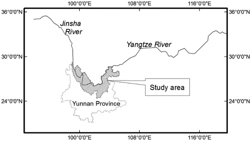
Yunnan Jinsha River watershed is located between 24°30′ and 29°15′ N, 98°40′ and 105°15′ (), with 49 counties and a total area of 110,883 km2. The river watershed belongs to the low-latitude, high-altitude subtropical climate zone, which can be divided into three types: dry-hot valleys, dry-warm valleys, and subtropical valleys, depending on the factors such as the atmospheric circulation system, the influence of the mountains on the movement of the monsoon, the foehn effect, and the local wind current systems. The formation of the try-hot valleys was explained in detail by Zhang (Citation1992) and Ma and McConchie (Citation2001). With complex geological structure in the river watershed, there are mainly faults and folds. The strata in the area are well exposed and there are strata of almost all ages. The valley area is mainly composed of the pre-Devonian metamorphic rocks, including schist, Quartz marble and metaphoric basic igneous rocks. In addition, Carboniferous, Permian, Triassic, Jurassic sedimentary and igneous rocks are also exposed while tertiary and Quaternary strata are rarely scattered in the area. As for soil, there are a total of 7 soil classes, 14 subclasses, and 16 soil types in the whole river watershed. The main soil types are red soil, yellow soil, yellow-brown soil, brown soil, dark brown soil, brown coniferous forest soil, torrid red soil, cinnamon soil, purple soil, lime soil, swamp soil, alpine meadow soil, alpine frozen soil, and paddy soil. Among them, the red soil is the most widespread type of soil in the river watershed.
Figure 1. Study area.
Because of the complex terrain and geological conditions, the watershed includes very complex and diverse forest vegetation types. There are 70 forest vegetation types within the river watershed (Wu Citation1987), and the warm coniferous forest takes the largest area of forest, including Yunnan pine and Huashan pine, which together takes 28.60% of the area. Moreover, the unique geographical location and geological history of the Jinsha River watershed also created valley vegetation types and unique dry-hot valley vegetation that are peculiar in southwestern China (Yang Citation2006).
The data collected for the study include terrain, geology, soil, rainfall, temperature and seismic intensity, and remotely sensed images of Jinsha River watershed. The scale for terrain and geological maps is 1:10 million. The datasets are processed in ArcGIS software to form layers of different factors. The remote sensing data used is Landsat-5 Thematic Mapper (TM) acquired in May 2009. The entire study area contains a total of 12 Landsat-5 TM images. ERDAS IMAGINE software is used to process these images. A spatial database is then established in ArcGIS software environment, including the spatial data and the attributive data. The spatial database is divided into the basic layers and thematic layers. Basic layers store all single feature data while thematic layers store data that are calculated, counted, and analyzed with the data in basic layers and other forms, such as slope and aspect derived from digital elevation models (DEM), NDVI map calculated from Landsat TM images, and rock types and faults extracted from geological maps.
3. Methods
3.1. Evaluate factors of physical environment for human settlements
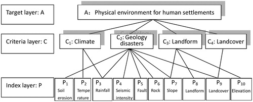
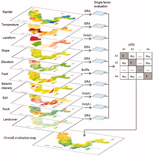
Climate, landform, geology disasters, and land-over were selected as evaluation factors of physical environment for human settlements in Jinsha watershed due to the following reasons: (1) the area has complex terrain and great altitude variations; (2) geological disasters such as landslides, mudslides and earthquakes occur in the area frequently; (3) there are significant regional variations in rainfall and temperature; and (4) the degree of surface cover in the upstream, midstream and downstream has a poor continuity. Climate factors include rainfall (average annual precipitation) and temperature; topographical factors include landform, slope and elevation; geological factors include earthquakes (seismic intensity), faults, soil erosion and rock types; and the land cover factor includes degree of vegetation cover ().
Figure 2. Evaluation index system for physical environments of human settlements.
3.2. Evaluation method
For evaluation of the single factors, there are mainly two methods, namely grey correlation method for evaluations of quantitative factors, and Delphi (expert scoring) method for the qualitative factors. Among them, the rock type and landform belong to the qualitative factors, which were evaluated using Delphi method in this study. Rainfall, temperature, soil erosion, seismic intensity, slope, elevation, and vegetation cover degree were evaluated using grey correlation degree.
Grey correlation analysis is mainly used for analyzing the dynamic relationships between various factors in order to find the system of the main factor, and has been used in many studies (Fang et al. Citation2017; Yuan et al. Citation2017; Sun et al. Citation2018). Grey correlation degree was calculated as:
(1)
(1)
where
x(k) is between 0 and 1, which is a dimensionless value representing the correlation degree between the evaluation value and optimal value of factor k in raster i;
C*(k) represents the optimal value of the kth evaluation factor;
C’i(k) represents the property value of the kth evaluation factor of the ith grid;
minimink|C*(k) − C’i(k)| is the two-stage minimum differential;
maximaxk|C*(k) − C’i(k)| is the two-stage maximum differential;
R is the resolution coefficient, whose value is 0.5 in this study.
In this study, different index systems have complex constitution and are under mutual restraint. Fault, rock type and slope together make up the upper index system of landslides and mudslides. Vegetation cover degree acts as the role of geological disasters, as well as the constituent of vegetation. Rainfall, as a climatic factor, is conducive to the physical environment for human settlements in an arid river watershed. But it is the inducing factor of many geological disasters, which is unfavourable. The index system of physical environment for human settlements in the study area can be analyzed using the analytical hierarchy process (AHP). More recent references on AHP can be found in Ivanco et al. (Citation2017), Oliva et al. (Citation2017), Ahmed and Kilic (Citation2018), and Ho and Ma (Citation2018), among others.
Based on raster data with a cell size of 300 m by 300 m, the GIS spatial overlay function is used to calculate the combination of the weights for individual single-factor layers calculated by AHP. The mathematical model used is:
(2)
(2)
where
i is the number of raster;
K is the number of evaluation factor;
n is the total number of the evaluation factors;
Siis the score of physical environment for human settlements of ith raster cell;
Wk is the kth weighting factor (determined by AHP);
x(k) represents the correlation degree between the kth evaluation factor of the ith raster and its optimal value.
3.3. Single factor evaluation
The factors of rainfall, temperature, slope, elevation, vegetation cover degree, soil and seismic intensity are quantitative factors. Grey correlation method (Formula (1)) was employed for evaluation of these factors.
Most parts of the Jinsha River watershed are arid, and rainfall has become the development limiting factor in some areas in the river watershed. Therefore, the grey correlation value can be calculated by the principle that more rainfall is beneficial to the physical environment for human settlements in the river watershed.
The average in the river watershed in the recent decade is about 15 °C. In most parts, the average temperature is at 10–18 °C for many years. Some relevant studies indicate that the optimum temperature for human survival is 18–22 °C (Refinetti and Menaker Citation1992). Therefore, the intermediate value 20 °C was identified as the optimum temperature. The evaluation map for temperature factor of physical environment for human settlements can be calculated by the grey correlation method.
Smaller slopes are more suitable for human habitation and development. Meanwhile, slope is a key factor in controlling geological disasters such as landslides, mudslides and collapses. Therefore, the grey correlation formula can be used to calculate the actual slope value for physical environment of human settlements.
The topographic in the study area has a high relief. The highest elevation is 5596 m while the lowest is 267 m. Due to the thin oxygen, difficulty of human activities, biological scarcity and low primary productivity, the evaluation map for elevation factor of physical environment for human settlements can be calculated from the DEM following the principle that higher elevation is not beneficial to human habitation.
Vegetation is the material base for human life. Vegetation is also closely related to the occurrence of geological disasters. Therefore, the higher degree of vegetation cover is beneficial to human habitation. With the use of vegetation index NDVI and grey correlation method, the evaluation map for vegetation factor of physical environment for human settlements can be calculated.
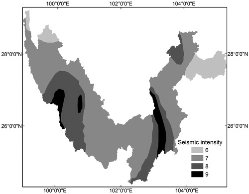
Yunnan Jinsha River watershed is in an earthquake-prone area. According to the historical records, there are 16 earthquakes with a magnitude of 5 or higher in the study area. Thus, earthquake became one of the limiting factors of physical environment for human settlements. Seismic intensity is an important indicator of area seismic safety. If seismic fortification intensity is higher, the greater the degree of earthquake-prone and destruction are. According to the seismic intensity zoning made by China Earthquake Administration, the area has a seismic intensity of 6–9 (). The evaluation of seismic intensity can be carried out using the grey correlation method.
Figure 3. Spatial pattern of seismic intensity in Jinsha River watershed (Yunnan part) (adapted from the China Earthquake Administration).
Physical properties of soils are an important factor controlling the mudslides and soil erosion in a certain area. The soil erodibility factor K is an important physical property of soil, with its values reflecting how easily soil is splashed, peeled and handled by rainfall erosion force. If the value of K is greater, the soil erosive resistance is worse. There are mainly methods to calculate k value of soil. Taking the available basic data of the study area and the operability of calculation in consideration, the method in EPIC (Erosion Productivity Impact Calculator) model by Sharpley and Williams (Citation1990) was used to calculate the value of K through the use of soil organic matter and soil mechanical composition. In this study, the soil particle size within the river watershed is divided to sand, silt and clay to calculate the soil erodibility factor K within the river watershed (). Then, the evaluation map for soil factor of physical environment for human settlements can be calculated by grey correlation method on the basis of the distribution of K in the river watershed.
Table 1. Soil properties and K values in Jinsha river watershed (Yunnan part).
Table 2. Geological hazard susceptibility of different rock types.
Qualitative factors like fault, earthquake, rocks and landforms can be scored using Delphi method.
Faults can cause common geological disasters, and should be avoided whenever possible in built-up areas. Faults are densely distributed in the study area. From the largest to the smallest, there are deep-large fault, great fault and small fault. The size of the fault and the buffer distance are chosen as the principles for scoring. Three different kinds of faults are scored in different levels according to the buffer distance. The point-deducting principle is used for calculating scores. The closer the fault, the more points are deducted. The higher level of the fault, the more points are deducted, and the lowest score is zero. In areas where several fault buffer zones intersect, the point deduction should be accumulated (the minimum is 0). The evaluation map for fault factor of physical environment for human settlements is shown in .
Figure 4. Fault evaluation for human settlements (higher values are more suitable for human settlement).
Rock type is one of the controlling factors of geological disasters like landslides, mudslides and collapse. Different rock types have different rock properties, which lead to different geological disaster prone degrees. In this study, Delphi method was used to score the damage that landslides, mudslides and collapse can cause. With scores of all experts averaged, the result was 0.3 for landslides, 0.5 for mudslides and 0.2 for collapse. Then, the priority of contribution to different kinds of geological disasters for different rock types and combinations of different rock types were determined. Experts’ priority statistics was calculated by weighted average. The calculation method for comprehensive ranking of each rock type is:
(3)
i is the number of disaster type (from 1 to 3);
W is comprehensive prone degree ordering of geological disaster of different rock types;
wi is the weight of the ith disaster type;
ri is the ordering of a certain type of rock in the ith geological disaster.
The results of the evaluation are shown in .
The impact of landform on the physical environment for human settlements lies in two aspects. The first is the direct impact on human habitation. The complex terrain, mountainous steep-slope areas make the physical environment for human settlements deteriorated, along with the decreasing of arable land, deterioration of production conditions and restriction of some construction sites. The second is that landform is closely related to geological disasters. Steep terrain can cause a variety of regional geological disasters like landslides, mudslides and collapse. From upstream to downstream in the river watershed, landform changes significantly. The upstream has three kinds of landforms: alpine canyon, karst plateau canyon, and middle mountain wide valley lake basin. In middle and upper sections of the river watershed, hilly plateau is the main landform. The downstream reaches are middle mountain hilly canyon and karst middle mountain canyon. Using the Delphi method for single factor evaluation of landform, the result of different landforms from best to worst is: hilly plateau area (1.0), the plateau lake basin area (0.72), the middle mountain wide valley lake basin area (0.71), the hilly plateau canyon area (0.56), the plateau canyon area (0.56), the hilly canyon area (0.46), the middle mountain karst canyon area (0.39), and the alpine canyon (0.26).
3.4. Overall evaluation
According to the weights calculated by AHP, the above single factor evaluation maps can be combined. The AHP method is to decompose the problem into different constituent elements and form a multi-level structural analysis model according to the aggregated combination of interrelated factors of different levels. Eventually the system analysis boils down to the determination of relative importance weight that the bottom relative to the top (the overall objective). AHP in overall evaluation of physical environment for human settlements can be divided into following four steps.
3.4.1. Building the judgment matrix
In AHP, it is necessary to form a value-featured judgment matrix in order to quantify the decision-making. According to Saaty (Citation1980) 1–9 scale method, the judgment matrix reflecting index system of physical environment for human settlements is constructed on the basis of the evaluation index system frame () and the consultation with experts. The judgment matrix A–C constructed with criteria layers like overall objective of physical environment for human settlements (A), climate (C1), geological disasters (C2), terrain and landform (C3), and vegetation (C4) is showed in .
Table 3. AHP judgment matrix of physical environment for human settlements.
The judgment matrix C1–P constructed with climatic factors (C1), the average annual temperature (P2) and the average annual rainfall (P3) is showed as .
Table 4. AHP judgment matrix of climatic factors.
The judgment C3–P matrix constructed with geological disasters element (C3), soil erodibility (P1), the average annual rainfall (P3), the seismic intensity (P4), fault (P5), rock type (P6), slope (P7) and vegetation cove degree (P9) is showed as .
Table 5. AHP judgment matrix of geological disasters element.
3.4.2. Hierarchical arrangement and consistency check
Hierarchical single arrangement refers to the calculation the relative importance ranking value (W) that every level (except the total target layer) of factor relative to the previous level. Consistency check means calculating consistency index and using the average random consistency index to calculate consistency ratio (CR). When CR is smaller than 0.1, the result of hierarchical single arrangement is considered to have a satisfactory consistency (Saaty Citation1980).
After doing hierarchical single arrangement and consistency check of A–C matrix, C1–P matrix, C2–P matrix and C3–P matrix between the objectives and the criteria layer (the CR of 4 matrices are 0.011, 0.001, 0.018 and 0.008), the sorting result is obtained for each factor (weights, ). The CRs of all matrices are all smaller than 0.1, the result of hierarchical single arrangement of every matrix is considered to have a satisfactory consistency.
Table 6. Hierarchical total arrangement.
The results of hierarchical total arrangement of the overall objective that soil (P1), the average annual temperature (P2), the average annual rainfall (P3), earthquakes (P4), fault (P5), rock type (P6), slope (P7), landform (P8), vegetation (P9), elevation (P10), etc. these single factors relative to the physical environment for human settlements are shown in . According to the consistency check of hierarchical total arrangement, the calculated CR is 0.014, which means a satisfactory consistency.
From the calculation results, the factor of the highest weight is slope, which shows the importance of slope to physical environment for human settlements in the Jinsha river watershed that has undulating terrain and mountain canyons. The factor of the second highest weight is vegetation cover degree. It is not only an important controlling factor of many geological disasters, but the important indicator of the primary productivity necessary for human survival as well.
3.4.4. Factors overlay analysis
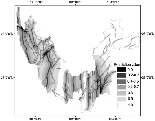
Finally, the comprehensive calculation of all single factors can be done with ArcGIS according to the above weights calculated by hierarchical analysis method and the comprehensive evaluation model (Formula (2)). Then, the overall evaluation map of physical environment for human settlements in Jinsha river watershed can be produced by factors overlay analysis in ArcGIS ().
Figure 5. Factor overlay analysis of physical environment for human settlements in Jinsha river watershed (Yunnan section, China).
4. Results and discussion
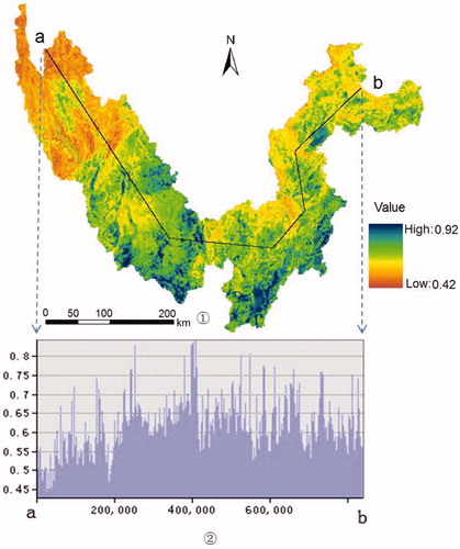
From the result of the overall evaluation of physical environment for human settlements in Yunnan Jinsha river watershed, the maximum score is 0.92 while the minimum is 0.42, the average of which is 0.64. In general, the scores on the spatial distribution are presented as: midstream > downstream > upstream.
In order to analyze the spatial distribution of the scores of physical environment for human settlements within the Yunnan Jinsha river watershed more clearly, the 3D analysis function of ArcGIS was used for profile analysis on the basis of route a–b along the longitudinal direction of the river watershed (:①). Then, the profile map of the comprehensive scoring of physical environment for human settlements is shown in :②. It can be seen that the scores in the upstream are very low, and the scores are in decreasing trend from the upstream to the downstream.
Figure 6. Comprehensive evaluation result and its profile map of physical environment for human settlements in Jinsha river watershed.
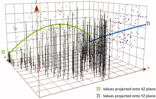
In addition, 3D trend analysis of the evaluation result was carried out in order to more clearly grasp the spatial distribution of the evaluation results. On the basis of the evaluation raster map, 171 raster points were randomly selected in the space and converted to a point file. The 3D trend analysis map () was produced using the ArcGIS Geostatistical Analyst module. From the projected trendline in the XZ plane (the line m in ), the evaluation value increases from west to east. The evaluation value reaches the maximum in the middle. And then to the east, the value decreases. The general trend is: middle > eastern > western. From the projected trendline in the YZ plane (the line n in ), the evaluation value decreases sharply from south to north, namely the southern areas are higher than the northern.
Figure 7. 3D-spatial trend analysis of the result about physical environment for human settlements in Jinsha river watershed. (In the figure, the positive direction of axis x refers to the East, the positive direction of axis y refers to the North and axis z refers to the evaluation value. Line m refers to the planar projection value of the evaluation value in the plane XZ and line n refers to the planar projection value of the evaluation value in the plane YZ.)
To sum up, the best area of physical environments for human settlements appears at the southern part of the central section. From south to north, the quality of the geological and ecological environment declines. From upstream to downstream (from west to east), the quality becomes better at first and further becomes worse. This is a comprehensive reflection of landform, geology, vegetation and climate. Due to the steep slope, the higher elevation, the intensive faults and low temperatures, the upstream of the Jinsha river watershed becomes the area with the worst geological and ecological environment. The downstream of the river watershed has lower elevation, fewer faults and almost no large faults. Due to the relatively low vegetation cover degree in some areas, the steep terrain and the dominating karst landform, the downstream area also becomes poor in geological and ecological environment. Most parts of the midstream of the river watershed have relatively flat terrain. Plateau lake basin and hilly plateau are main landforms in this area and the climate is mild. In general, the midstream is the best area for human settlements in the river watershed.
In addition to the general trend, there are obvious differences in physical environment for human settlements in different river watersheds sections. Due to the high seismic intensity, the distribution of deep-large faults, the weak rock properties (mudstone and siltstone mainly), a few parts of the midstream area become poor in the physical environment for human settlements evaluation. The area of Shangri-La County in the upstream has the relative flat terrain so that it has a relatively good physical environment for human settlements in comparison to the general poor situation of the upstream area. Some areas in the middle and upper reaches of the river watershed have relatively flat terrains. However, due to the influence of dry and hot valley climate, the low vegetation cover degree, the high temperature of the average years, and the low rainfall and in the highly seismic fortified area, the areas in the middle and upper reaches of the river watershed have a low evaluation score and become poor in the physical environment for human settlements evaluation. Moreover, some areas in the middle and lower reaches of the river watershed (Dongchuan District and its surrounding areas) become poor in the physical environment for human settlements of the midstream area due to the distribution of large faults (Xiaojiang fault), the weak rock properties, the high seismic fortification intensity, and the poor vegetation cover degree.
5. Conclusions
Yunnan Jinsha river watershed has complex terrain and frequent occurrence of geological disasters like landslides, mudslides, collapses and earthquakes. The landforms of the upstream and downstream area have various features. The spatial distribution difference of factors like rainfall, temperature, landcover and soil erodibility is obvious. Therefore, the leading factors that affect the physical environment for human settlements in Yunnan Jinsha river watershed were determined as climate, geological disasters, landform and landcover.
From the evaluation results of physical environment for human settlements in Yunnan Jinsha river watershed, the suitability degree of the physical environment for human settlements is as follows: midstream > downstream > upstream. The spatial distribution of physical environment for human settlements within the river watershed is a comprehensive reflection of geology, landform, vegetation and climate. The upstream area belongs to the alpine canyon area, and with the intensive faults and high elevation, its physical environment for human settlements is poor. The downstream area mostly belongs to the middle mountain karst canyon area. Because of the severely damaged vegetation, the physical environment is in the middle level. The midstream area belongs to the hilly plateau and the plateau lake basin area, whose terrain is relatively flat. It becomes relatively good in geological and ecological environment. But because of the high seismic fortified intensity, the distribution of deep-large faults and the weak rock properties, in some parts of the midstream area, there are also a few areas of poor physical environment for human settlements.
In this study, the evaluation methods of physical environment for human settlements include GIS, remote sensing, spatial statistics, AHP, and the grey correlation method. Especially, the overlay analysis, 3D perspective and spatial patterns analysis of GIS provide a good technical support for the intuitive display of the evaluation and spatial distribution of the physical environment. The study shows that the method is efficient and accurate.
From the results of the evaluation, the physical environment of the upstream area, the downstream area and a few areas (like Dongchuan) in midstream are fragile. The population of the upstream area is small. But because of lying in the upstream area, the ecological negative effects produced by human activities can easily have an impact on the whole river watershed. Therefore, the current population density should be retained, large-scale anthropogenic disturbance work should be reduced, and the protection of vegetation should be enhanced. Most parts of the midstream area have good physical environment for human settlements. Although its overall population is quite concentrated, the population of some counties (like Xuanwei and Malong) is relatively small and there is still huge space to be used. Therefore, the local ecological environment should be protected and these counties should be determined as the refuge areas or the relocation destinations in the events of geological disasters. There are also some areas (like Dongchuan and Huize) in the midstream that have relatively weak physical environment for human settlements and large population density. The protection of these areas should be strengthened and the appropriate refuge and resettlement work should be done. Most downstream areas of the Jinsha River watershed have steep terrains, fragmented landforms, sparse vegetation, and high population density. It is recommended that the area be classified as an ecological protection area.
The research methods and index systems could be extended to the study of physical environment for human settlements in other river watersheds with complex terrain (such as alpine canyons with complex geological conditions and the frequent occurrence of earthquakes). The study also provides a scientific basis for pre-disaster planning and post-disaster response, and site selection of large projects.
| Abbreviations | ||
| AHP | = | Analytical Hierarchy Process |
| CR | = | Consistency Ratio |
| DEM | = | Digital Elevation Model |
| EPIC | = | Erosion Productivity Impact Calculator |
| GIS | = | Geographic Information System |
| NDVI | = | Normalized Difference Vegetation Index |
| TM | = | Thematic Mapper |
Disclosure statement
No potential conflict of interest was reported by the authors.
Additional information
Funding
Related Research Data
References
- Ahmed F, Kilic K. 2018. Fuzzy analytic hierarchy process: a performance analysis of various algorithms. Fuzzy Sets Syst. doi: 10.1016/j.fss.2018.08.009.
- Chen SS, Zhang OY, Chen ZF, Peng WB. 2008. Variations of runoff and sediment load of the Jinsha river. Adv Water Sci. 19(4):475–482.
- Chowdhury PKR, Bhaduri BL, McKee JJ. 2018. Estimating urban areas: new insights from very high-resolution human settlement data. Remote Sens Appl: Soc Environ. 10:93–103.
- Doxiadis CA. 1970a. Ekistics, the science of human settlements. Science. 170(3956):393–404.
- Doxiadis CA. 1970b. Man’s movement and his settlements? Int J Environ Stud. 1(1–4):19–30.
- Doxiadis CA. 1975. Action for human settlements. Ekistics. 40(241):405–448.
- Du J, Shi C, Zhang C. 2013. Modeling and analysis of effects of precipitation and vegetation coverage on runoff and sediment yield in Jinsha River Basin. Water Sci Eng. 6(1):44–58.
- Esch T, Heldens W, Hirner A, Keil M, Marconcini M, Roth A, Zeidler J, Dech S, Strano E. 2017. Breaking new ground in mapping human settlements from space – the Global Urban Footprint. ISPRS J Photogram Remote Sens. 134:30–42.
- Fang S, Yao X, Zhang J, Han M. 2017. Grey correlation analysis on travel modes and their influence factors. Procedia Eng. 174:347–352.
- Gamba P, Stilla U, Juergens C, Maktav D. 2012. Foreword to the special issue on human settlement monitoring using multiple earth observation data. IEEE J Sel Top Appl Earth Obs Remote Sens. 5(4):1071–1075.
- Gamba P, Tupin F, Weng QH. 2008. Introduction to the issue on remote sensing of human settlements: status and challenges. IEEE J Sel Top Appl Earth Obs Remote Sens. 1(2):82–86.
- Gao JG, Wu X, Zhang YL, Liu LS, Wang ZF, Yao ZJ. 2016. Ecological function regionalization in the lower Jinsha River Basin using analytic hierarchy process method. Acta Ecol Sin. 36(1):134–147.
- Ho W, Ma X. 2018. The state-of-the-art integrations and applications of the analytic hierarchy process. Eur J Oper Res. 267(2):399–414.
- Ivanco M, Hou G, Michaeli J. 2017. Sensitivity analysis method to address user disparities in the analytic hierarchy process. Expert Syst Appl. 90:111–126.
- Li D, Lu X, Yang X, Chen L, Lin L. 2018. Sediment load responses to climate variation and cascade reservoirs in the Yangtze River: a case study of the Jinsha River. Geomorphology. 322: 41–52. doi: 10.1016/j.geomorph.2018.08.038.
- Li X, Gong P. 2016. An “exclusion-inclusion” framework for extracting human settlements in rapidly developing regions of China from Landsat images. Remote Sens Environ. 186:286–296.
- Li YC, Liu CX, Zhang H, Gao X. 2011. Evaluation on the human settlements environment suitability in the Three Gorges Reservoir Area of Chongqing based on RS and GIS. J Geogr Sci. 21(2):346–358.
- Lin Y, Cui P, Ge Y, Chen C, Wang D, Wu C, Li J, Yu W, Zhang G, Lin H. 2014. The succession characteristics of soil erosion during different vegetation succession stages in dry-hot river valley of Jinsha River, upper reaches of Yangtze River. Ecol Eng. 62:13–26.
- Lu D, Tian H, Zhou G, Ge H. 2008. Regional mapping of human settlements in southeastern China with multisensor remotely sensed data. Remote Sens Environ. 112(9):3668–3679.
- Ma HC, McConchie JA. 2001. The dry-hot valleys and forestation in southwest China. J For Res. 12(1):35–39.
- Oliva G, Setola G, Scala A. 2017. Sparse and distributed analytic hierarchy process. Automatica. 85:211–220.
- Peng YZ, Fan JR, Yu J, Zhu X. 2018. Spatial and temporal distribution of rainfall erosivity in Jinsha River Basin. Bull Soil Land Water Conserv. 38(2):8–13.
- Refinetti R, Menaker M. 1992. The circadian rhythm of body temperature. Physiol Behav. 51(3):613–637.
- Saaty TL. 1980. The analytic hierarchy process. New York: McGraw-Hill.
- Sharpley AN, Williams JR. 1990. EPIC erosion/productivity impact calculator: 1. Model documentation. Washington, DC: USA Government Printing Office. USA Department of Agriculture Technical Bulletin No. 1768.
- Sun G, Guan X, Yi X, Zhou Z. 2018. Grey relational analysis between hesitant fuzzy sets with applications to pattern recognition. Expert Syst Appl. 92:521–532.
- Wang K, Chen N, Tong D, Wang K, Gong J. 2015. Optimizing the configuration of streamflow stations based on coverage maximization: a case study of the Jinsha River Basin. J Hydrol. 527:172–183.
- Wei W, Shi P, Zhou J, Feng H, Wang X, Wang X. 2013. Environmental suitability evaluation for human settlements in an arid inland river basin: a case study of the Shiyang River Basin. J Geogr Sci. 23(2):331–343.
- Wu ZY. 1987. The vegetation of Yunnan. Beijing: China Science Press.
- Yang SH. 2006. Ecological protection of watershed ecosystem and its digital management – a case study of Jinsha river basin in Yunnan, China. Beijing: China Science Press.
- Yuan Z, Wu L, Yuan Z, Li H. 2017. Shape optimization of welded plate heat exchangers based on grey correlation theory. Appl Therm Eng. 123:761–769.
- Zhang Q, Zhu C, Liu CL, Jiang T. 2005. Environmental change and its impacts on human settlement in the Yangtze Delta. CATENA. 60(3):267–277.
- Zhang R. 1992. Publication series of the scientific survey on Qingzang Plateau: dry valley in the Hengduan Mountainous Area. Beijing: Science Press; p. 10–60.
- Zhao J, Xu M, Lu SL, Cao CX. 2013. Human settlement evaluation in mountain areas based on remote sensing, GIS and ecological niche modeling. J Mt Sci. 10(3):378–387.
- Zhao X, Sun H, Chen B, Xia X, Li P. 2018. China’s rural human settlements: qualitative evaluation, quantitative analysis and policy implications. Ecol Indic. doi: 10.1016/j.ecolind.2018.01.006.