
 ?Mathematical formulae have been encoded as MathML and are displayed in this HTML version using MathJax in order to improve their display. Uncheck the box to turn MathJax off. This feature requires Javascript. Click on a formula to zoom.
ABSTRACT
With the development of new methods and the tremendous progress in transducer technology, the observations and researches have become more and more stereoscopic and full-scale. In order to build the multi-source data fusion system propping up the computations, such as process evolution prediction, structure discovery and association analysis, the digital modelling of the natural entity needs to be carried out, which would help build the corresponding digital entity. In this study, the concepts and models in geoscience are introduced, and the issues overlooked in the digital modelling theories are discussed. On this basis, a unified conceptual model and its pseudo-representation (BPRModel) are built. Furthermore, the application of the model is illustrated under the research of specific natural entity, that is to say, the Earth’s magnetosphere.
1. Introduction
With the rapid progress and tremendous applications of the digitised, intelligent and networked transducer technology, the observations of natural entity in geosciences, space sciences and other related fields have become more and more full-scale, stereoscopic and refined. As a result, enormous scientific data is generated, and the research and computing focusing on natural entity have entered a new era of being multi-sourced and multi-layered. The natural entity that has been discussed in this paper is defined as an object with its evolving process or related events in the real world. The most intrinsic characteristic of the natural entity is that it has three attributive entities, namely the spatial entity, the temporal entity and the element entity. The objects that do not hold this characteristic are not discussed in the scope of the current paper.
Natural entity computing refers to retrieval, visualisation and analysis of the attributive information. It also involves the evolutionary analysis of the processes and the prediction of the development of various events. These computations are performed on the digital entity. It has become one of the key challenges in the research of natural entity computing to develop the digital entity supporting the fusion of multi-source and multi-layered observation data and realise the fusion system for multi-source data, thus propping up the computations, such as process evolution prediction, structure discovery and association analysis.
The geo-entities proposed in geoscience have the spatial, temporal and element attributes. The three attributes and their relations are of great importance in the study of geosciences. We hold the opinion that the concept of natural entity includes, but is not limited to, that of geo-entity. Geoscientists have proposed several models for the digitalisation of geo-entities. In general, the process of digital modelling can be classified into three different levels, namely the conceptual modelling, the logical modelling and the physical modelling (Conceptual, logical and physical data model). These are the levels of abstractions of the three attributive entities of natural entity as well as the relations between them. The conceptual modelling is the first-level abstraction, which defines the entities and relations using mathematical notations, figures and unified modelling language (UML). For example, the PGOModel (Kjenstad Citation2006) uses the UML class to represent entities and the UML class relations to represent relationships between them. The logical modelling normalises the conceptual model into data structures, such as the object-oriented spatial-temporal data model (Gong Citation1997) and the point-set topological model (Egenhofer and Franzosa Citation1991). The physical modelling depicts the representation and the access methods of the data, which concerns the specific computer and data management systems. It is difficult and usually unnecessary to build a unified representation for the physical modelling level. Due to this reason, we will not discuss the models in detail in this paper. The digital modelling in geosciences are built for practical applications. For example, the point-set topological model is built specifically to define the spatial topological relations, while the PGOModel is a unified model to represent the relations between the element entity and the spatial-temporal entity. These models are usually focused on one kind of relations, lack universality and generality, hence fail to build a theoretical framework with concepts and methodologies from the perspective of complete process of digital modelling.
In this paper, the concept of natural entity is proposed, and a unified conceptual design of digital modelling is constructed. Using the UML, a pseudo-representation model called the Basic Pseudo-Representation Model (BPRModel) is built. On this basis, the BPRModel is applied to Earth’s magnetosphere, which is considered as the specific natural entity and the point of research in the current work.
The purpose of this paper is to offer a conceptual and theoretical framework to clarify and integrate the concepts of natural entity and its digital modelling, so that it could help build the digital modelling on the physical level when a certain entity is considered. The corresponding digital entity, which is constructed using the guidance of the conceptual model and the proposed BPRModel, builds the foundations for natural entity computing including data fusion.
2. Conceptual model of the digital modelling
2.1. Formalisation of the natural entity
The formalisation of natural entity essentially includes the formalisation of spatial entity, the temporal entity, and the element entity.
One of the most common ways to formalise the spatial and temporal entities is discretisation. The results of the formalisation consist of spatial cells, temporal cells and their inherent relations.
There are generally three ways to formalise the spatial entity, the point discretisation, the subdivision and the vector method. Sampling (Goodchild and Frank Citation1992) is a typical case of point discretisation. The spatial cells are points, whereas the inherent relations are the spatial adjacencies between these sampled points. Triangulated irregular network (TIN) (Tsai and Victor Citation1993, Chang Citation2014) and tetrahedron network (TEN) (Pilouk et al. Citation1994) are two other formalisation methods involving point discretisation, and were proposed for irregular planes and solids. Based upon sampled points, TIN and TEN formalise the spatial entity into triangles and tetrahedrons, respectively. In this case, the spatial cells are points, lines, triangles and tetrahedrons, whereas the inherent relations are the spatial topological relations.
Subdivision is the second formalisation method for the spatial entities, and recursively discretizes the spatial entity into a series of hierarchical cells in a uniform and predictable manner. The resulting fine cells may be assigned to coarse cells as children, and have the same dimensionality with their parent cells in the parametric space. For example, the raster model (Goodchild Citation1992, Chang Citation2014), the discrete global grid systems (DGGS) (Sahr et al. Citation2003, Mahdavi-Amiri et al. Citation2015, Zhao et al. Citation2016), the three dimensional (3D) space grids, such as the sphere degenerated octree gird (SDOG) (Wu and Yu Citation2009), the extended octree (e-Octree) (Cao Citation2012), and the Yin-Yang grid (Kageyama and Sato Citation2004) are the subdivision models for planes, the surface of the Earth, and the 3D Earth sphere, respectively. The formalisation results of these models are composed of different types of spatial grids as spatial cells, while the hierarchical relations and the adjacencies among the grids are treated as their inherent relations.
Vector method is the third formalisation method (Chang Citation2014). The vector method discretizes the spatial entity into a combination of cells that have the same or lower dimensionality with the spatial entity. In general, the inherent relations among these spatial cells are represented by the spatial topological relations.
The temporal entity discussed in the current paper is taken as a 1D entity in the parametric space. The formalisation methods include equal-interval time discretisation (Kang et al. Citation2017) and flexible-interval time discretisation (Allen Citation1983, Peuquet and Duan Citation1995, Shu et al. Citation1997). The formalisation takes time-points and time-intervals as the temporal cells, while the inherent relations between them are usually referred to as the temporal ordering relations (Peuquet and Duan Citation1995, Kang et al. Citation2017) and temporal topological relations (Allen Citation1983, Hong. et al. Citation1997).
Moreover, in consideration of the correspondence between the spatial and temporal entities, a spatial cell and a temporal cell can be paired as a coupled spatial-temporal cell. The inherent relations among the coupled spatial-temporal cells mainly include the spatial-temporal adjacency (Kang et al. Citation2017) and the spatial-temporal topological relations (Claramunt and Jiang Citation2001, Xue and Su Citation2008).
The spatial and temporal entities are collectively called the spatial-temporal domain of the natural entity. The coupled spatial-temporal cells are also regarded as the cells of the spatial-temporal domain. The formalisation of the element entity refers to the construction of mapping relations between the element entity and the spatial-temporal domain. The formalisation results are the mapping relations. According to the intrinsic characteristics, the formalisation can be divided into two categories, namely the field-based formalisation and the object-based formalisation. The two formalisation categories are analogous to the field-based and object-based views in geoscience, respectively (Cova and Goodchild Citation2002).
2.2. Formal representations
The formalisation results correspond to the formalisation methods, whereas the formal representations vary with the intrinsic characteristics of the results. The most commonly used representations are encodings, relational tables, UML, and mathematical functions.
Encodings are one of the most widely used formal representations. Most of the cells are represented by encodings, including the cells of the subdivision formalisation, the points, lines, and the polygons of the vector formalisation method. The spatial relations, such as the hierarchical relations and adjacency can be represented by encodings. This can significantly simplify the computations of the relations.
Relational tables are of great popularity in representing the topological relations, including spatial topology, temporal topology, and spatial-temporal topology. Moreover, the mapping from spatial-temporal domain to the value space of the element entity is usually represented by tables.
UML is an important formal representation, widely used in the object-oriented models, such as object-oriented spatial data models (Chang Citation2014) and object-oriented spatial-temporal data models (Gong Citation1997). The UML classes are often used as representations of cells, while the relations are represented by the UML class relations.
2.3. Conceptual model
Based upon the summarisation and induction of the abovementioned models, a conceptual model for the digital modelling of the natural entities is proposed, as shown in .
Figure 1. The conceptual model of the digital modelling.
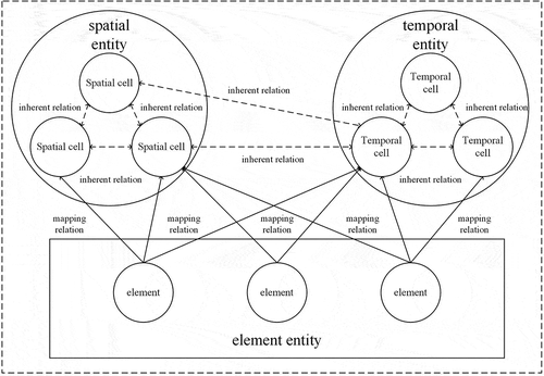
The conceptual model is an intuitive illustration of the digital modelling. The process includes two steps, namely the formalisation of natural entity and the formal representations of the formalisation results. There are basically two types of cells, namely the spatial cells and the temporal cells. Furthermore, there are two types of pivotal relations, namely the inherent relations between the spatial and temporal cells, and the mapping relations between the element entity and the spatial-temporal domain. Formal representations of these results include encodings, relational tables, and UML.
3. A unified formal representation model
3.1. Literature review of pseudo-representation models
The models mentioned above represent the digital modelling of one or more specific natural entities, proposing idiographic formalisation methods as well as the corresponding representation models. Apparently, these representation models have one-to-one relation with the digital modelling of one specific natural entity. For example, not all of the mapping relations between all kinds of elements and the spatial-temporal domain can be represented using one single specific mathematical function.
In the field of geoscience, many scholars have tried to extract unified forms of digital modelling through pseudo-representation models. Mathematical notations, relational tables and UML are the three commonly used methods to build pseudo-representations. summarises the typical models used in geosciences and their representation forms. It is clear that some of the models are aimed at supporting the computations of spatial and temporal relations, such as the point-set model (Egenhofer and Franzosa Citation1991) for spatial topological relations and the temporal interval model (Allen Citation1983) for events’ temporal topological relations. Therefore, these models emphasise on representing the inherent relations between the spatial and temporal cells. On the other hand, models such as the geo-atom model (Goodchild et al. Citation2007) and PGOModel (Kjenstad Citation2006) are focused on unifying the field-view and object-view of geoscience. These models mainly focus on representing the mapping relations, and ignore the spatial and temporal cells as well as the inherent relations.
Table 1. The typical pseudo-representation models
Compared with other formal representation forms, UML has a natural association with the object-oriented programming languages. In the following sections, a pseudo-representation model, called the basic pseudo-representation model (BPRModel) that is based on the complete process of digital modelling is proposed. The BPRModel is also listed in for comparison purposes.
3.2. Basic Pseudo-Representation Model (BPRModel)
shows the BPRModel, in which UML classes represent the cells, whereas the UML class relations, such as composition and dependency represent the pivotal relations.
Figure 2. The unified basic pseudo-representation model (BPRModel) of the digital modelling.
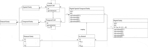
A natural entity, denoted as NE, consists of a spatial entity (SE), a temporal entity (TE) and an element entity (EE). In the current work, a mathematical set has been used to represent NE such that:. The element entity includes K types of elements, which can be represented as
. Furthermore,
represents the
element and has Q dimensions collected in a vector, so that:
, where Q is a variable that changes with k, and is denoted by:
. For example, if
(the symbol ‘
’ means ‘belongs to’) represents the geomagnetic intensity, it is then a vector of dimensions
, which means that:
, with each dimension to be a projection of the magnetic field:
. Particularly, if
represents a scalar element, (for example temperature), then
. Additionally,
is a scalar, given by:
.
In the BPRModel, the spatial cell is represented by a UML class. The ‘self-UMLRelation’ of the spatial cell class represents a possible discretisation of the cells, enabling hierarchical structures of the instances. In addition, is a descriptor representing an arbitrary spatial cell. Meanwhile,
denotes the operations defined on the spatial cell class, such as the calculation of the area of a cell. The representations of the operations are beyond the scope of current paper. Therefore, the specific formal representations are not defined for the operations provided hereinafter. More focus is laid on the formal representations of the formalisation results. Definitions concerning the temporal cell class are similar to those of the spatial cell class.
is a descriptor of the temporal cell class, representing an arbitrary temporal cell. Similarly,
denotes the coupled spatial-temporal cell class. In this paper, an ordered pair of a spatial cell and a temporal cell has been used to represent a coupled spatial-temporal cell, which can be represented as:
.
The inherent relations among the spatial cells are represented by a set.
As far as we know, there are four types of spatial relations, namely the topological relation (), the ordering relation (
), the metrics relation (
) and the spatial adjacency (
) (Egenhofer et al. Citation1999).
The inherent relations between the temporal cells generally include temporal ordering and temporal topology.
Moreover, represents the relations between the coupled spatial-temporal cells, which mainly consist of the spatial-temporal adjacency and spatial-temporal topological relations, which are denoted by
and
, respectively.
The digital entities are also represented by UML classes. The digital spatial entity is the digital object of the spatial entity. It should include all the cell representations denoted by SU, as well as the organisation of the cells implemented by representing one of the inherent relations of that is denoted by
. The definitions of the digital temporal entity are similar. All the coupled spatial-temporal cells are denoted as STU, where
, and the symbol ‘
’ stands for Cartesian product.
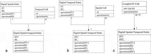
shows three ways to reconstruct the digital spatial-temporal entity (DSTE). The first way to reconstruct the is to first construct the digital spatial entity, and then pair
to the digital spatial entity (see )). A classic model for this construction method is the sequential snapshots model (Langran Citation1992). The second way, as shown in ), is to reconstruct the digital temporal entity by the representation of
and
. The digital spatial-temporal entity is constructed by pairing
to the digital temporal entity, whereas a typical model is the ESTDM (Peuquet and Duan Citation1995). The third method, as shown in ), is to reconstruct directly with the coupled spatial-temporal cells,
, through one of the inherent relations between the spatial-temporal cells,
. A typical model is the HTM-ST model (Kang et al. Citation2017), which involves building the digital spatial-temporal entity by representing the spatial-temporal cells and their adjacency with encodings.
Figure 3. (a). The reconstruction of the digital spatial-temporal entity based on space. This method is to build the digital spatial entity and pair all of the N temporal cells with the digital spatial entity. b). The reconstruction of the digital spatial-temporal entity based on time. This method is to build the digital temporal entity and pair all of the M spatial cells with the digital temporal entity. (c). The reconstruction of the digital spatial-temporal entity with coupled spatial-temporal cells by representing the inherent relations between them.
In the BPRModel, these three classes of digital spatial-temporal entities are unified in one form, which is the parent class of the three, shown as Figure 4. employs the same method that is used for the reconstruction procedure.
indicates that the reconstruction procedure was space-based, as shown by ). When
, the time-based method, as shown in ), is used. When
, the spatial-temporal-based method, as shown in ), is used.
The formalisation of the element entity is usually achieved by building the mapping relations between the elements and the spatial-temporal domain through a procedure that is called the element mapping. This paper uses the vector to represent the values of
in a specific spatial-temporal domain. As mentioned before,
is a vector with Q dimensions. Therefore,
denotes the value of the
dimension of the
element (
). In particular, if
is a scalar element,
is a scalar with
. The element mapping procedure is a relation represented by EquationEquation (5)
(5)
(5) .
As stated in Section 2.1, the formalisation of the mapping relations are divided into two categories, namely the field-based formalisation and the object-based formalisation. The field-based formalisation builds the mapping from the whole spatial-temporal domain to the value space of the element, while the object-based formalisation builds the mapping from a subset of the spatial-temporal domain. Therefore, in EquationEquation (5)(5)
(5) , if
is object-based,
.
The mapping relations represented as EquationEquation (5)(5)
(5) are represented in the condition connecting the value of the element to one stu in the spatial-temporal domain. However, the processes must often be understood in terms of interactions. For example, the demographic distributions are related to migrants between two or more spatial-temporal cells. Therefore, while EquationEquation (5)
(5)
(5) can also be written as EquationEquation (6)
(6)
(6) , the interactions can be represented as EquationEquation (7)
(7)
(7) .
In EquationEquations (5)(5)
(5) , (Equation6
(6)
(6) ) and (Equation7
(7)
(7) ),
is considered a mapping relation between the digital spatial-temporal entity to one of the elements of the element entity. Therefore, it is a function from the spatial-temporal domain, which is a subset of the P-dimensional parameter space
, to a Q-dimensional value space. The function is normally non-surjective (Weisstein Citation2004: Topic ‘Surjection’) and non-injective (Weisstein Citation2004: Topic ‘Injection’).
The definitions and representations in the BPRModel are supposed to be explicit and determinate. However, it is easy to find examples of vagueness. First of all, the mapping relations are often concerned with vagueness. For example, the mapping relation between the spatial-temporal domain of a mountain and the ‘whether it is the peak’ element will need to be studied with fuzzy set methods (Fisher et al. Citation2007) for the vagueness. Moreover, the spatial entity and the temporal entity can be uncertain (e.g. in case of wildfires). It is the case of natural entities with indeterminate boundaries (Burrough and Frank Citation1996). The locations defined by coordinates are regarded as an element of EE, whereas the indeterminate boundaries is a special case of a vague mapping relation from the to the value space of the location. The mapping f is a membership function that gives the degree of membership of the location as stu.
The BPRModel includes the representations of the spatial and temporal cells and the two pivotal relations between the spatial, the temporal and the element entity. Therefore, it is implied that the BPRModel is a unified and complete model for the digital modelling of the natural entities.
4. Application of the BPRModel to study the magnetosphere
The research on the magnetosphere are of great interest in the field of space science. The magnetosphere is a well-defined natural entity, particularly when the extent of the spatial entity and the temporal entity are confined in a specific research scenario. The BPRModel can be applied to the magnetosphere as shown by the results presented in .
Table 2. Representations of the magnetosphere
In this paper, the spatial entity is defined as the region surrounded by three surfaces, namely a sphere of , a cylinder of radius 10
, and the plane
. Here,
is the Earth radius, and X is the axis from the Earth core to the sun. Furthermore, the temporal entity is determined by the specific researches. One such example is the four-year time span from 1 January 2013 to 31 December 2016.
For the studies on the distribution of particles in the magnetosphere, the element entity mainly includes the magnetic field intensity and the particle flux. If we consider a bunch of specific particles, the element entity also includes the pitch angles and the velocity of these particles. Therefore, consider , such that:
. Here,
represents the magnetic field intensity, and
. Furthermore,
represents the particle flux of a certain type of particles, denoted by
. The formalisation for
and
is field-based, with every cell of the spatial-temporal domain mapping to the element’s value space. On the other hand,
represents the pitch angles of this bunch of particles under research, while
is the velocity. Therefore,
and
. The mapping relations between these two elements and the spatial-temporal domain are built by mapping from a subset of the spatial-temporal domain, which is related to the bunch of particles’ current states, to the corresponding value space.
The application form of the BPRModel for the magnetic field, as defined above, is presented in . The spatial-temporal units (stu) are represented by in , which is computable once the formalisation and representation methods of the spatial entity and the temporal entity are determined. Therefore, the inherent relations
can also be represented by
and its computations. In order to unify the two types of mapping relations, is designed as column-based, and the mapping relations are represented by the relations between the columns and the row keys, as denoted by
.
5. Discussion and future outlook
In order to support the computations, such as the data fusion, the retrieval and visualisation, the digital entity needs to be constructed so as to be processable by the computers. Considering the features of the natural entities, the digital modelling of the natural entity, namely the construction of the digital entity, includes the formalisation of the natural entity and the formal representations of the formalisation results. In this paper, the concepts and the data models of geo-entities are inspected and extended. A unified conceptual model and a pseudo-representation mode (BPRModel) are constructed. Moreover, we discussed the application of BPRModel by taking the Earth’s magnetosphere as the specific natural entity.
There are still a few issues, which need to be stressed. First is the definition of the spatial entity. In this paper, the spatial entity only refers to the extent and geometry of the natural entity, while the location described by coordinates is considered as a single element of the element entity. Secondly, the spatial-temporal variations are not discussed in the current paper. According to the definitions and features of the natural entities, the spatial-temporal variations can be divided into four types, namely the stationary, the extent variations, the entity value variations and the extent and entity value variations. With different types, the preferable method chosen for the reconstruction of the spatial-temporal digital modelling may be different. If the changes of the geometry and the extent are considered (the features of the spatial entity change with time), the reconstruction of the digital spatial-temporal entity based on time may be a preferable candidate for digital modelling. Moreover, if the changes are rapid and drastic (for example, hurricanes, or real-time systems such as moving objects), the reconstruction based on the coupled spatial-temporal cells may be a better choice. With slow and gentle changes, such as the seasonal expansion of a lake, the reconstruction based on either the space or time may be easier to process.
With regards to the future works, there are still certain issues that need to be addressed. Firstly, all the operations are not specifically represented, as stated in Section 3.2. The representations of the operations are one of the footstones for computing the natural entity. For example, once the methods of the formalisation and the formal representations are determined for the Earth’s magnetosphere, the data interpolation and averaging operations can be constructed so as to implement the pixel-level data fusion with multi-resolution data of the same dimension from different satellites that are presented in . However, these operations are not represented in detail in the conceptual model and the BPRModel. The focus of our future work will be on the unified representations of operations. Secondly, the data modelling on the physical level is not discussed in this paper. The forms of the physical data modelling are closely related to the operating systems and the data management systems. At present, it does not seem necessary to build unified theoretical models on the physical modelling level. We are working on building the digital entity of the Earth’s magnetosphere (the ‘digital Earth’s magnetosphere’) with the Ubuntu system and HBase database to support the natural entity computing, such as data fusion of multi-source, multi-structured data, particle motion analysis and the forecasting of relativistic electron flux.
Acknowledgements
We thank the National Space Science Data Center (NSSDC) for providing data resources and test platform. We also would like to thank the Space Science Data Fusion Computing Platform of the Public Technology Service Center of the National Space Science Center for providing computing services. We would also like to express our gratitude to EditSprings (https://www.editsprings.com/) for the expert linguistic services provided.
Correction Statement
This article has been republished with minor changes. These changes do not impact the academic content of the article.
Additional information
Funding
References
- Allen, J.F., 1983. Maintaining Knowledge about Temporal Intervals. Readings in Qualitative Reasoning about Physical Systems, 26 (11), 361–372.
- Burrough, P.A. and Frank, A.U., 1996. Geographic objects with indeterminate boundaries. London: Taylor & Francis Ltd.
- Cao, X., 2012. Research on Earth sphere shell space grid theory and algorithms. Thesis (PhD). Zhengzhou: The PLA Information Engineering University.
- Chang, K.-T., 2014. Introduction to geographic information systems. 7th. New York: McGraw-Hill Higher Education.
- Claramunt, C. and Jiang, B., 2001. An integrated representation of spatial and temporal relationships between evolving regions. Journal of Geographical Systems, 3 (4), 411–428. doi:https://doi.org/10.1007/s101090100066.
- Conceptual, logical and physical data model [online]. Hong Kong, Visual Paradigm. Available from: https://www.visual-paradigm.com/support/documents/vpuserguide/3563/3564/85378_conceptual,l.html [Accessed 20 September 2019]
- Cova, T.J. and Goodchild, M.F., 2002. Extending geographical representation to include fields of spatial objects. International Journal of Geographical Information Science, 16 (6), 509–532. doi:https://doi.org/10.1080/13658810210137040.
- Egenhofer, M.J., et al. 1999. Progress in computational methods for representing geographical concepts. International Journal of Geographical Information Science, 13 (8), 775–796. doi:https://doi.org/10.1080/136588199241012.
- Egenhofer, M.J. and Franzosa, R.D., 1991. Point-set topological spatial relations. International Journal of Geographical Information Systems, 5 (2), 161–174. doi:https://doi.org/10.1080/02693799108927841.
- Fisher, P., et al., 2007. Higher order vagueness in geographical information: empirical geographical population of type n fuzzy sets. GeoInformatica, 11 (3), 311–330.
- Gong, J., 1997. An object-oriented spatio-temporal data model in GIS. Acta Geodaetica et Cartographica Sinica, 26 (4), 289–298.
- Goodchild, M.F., 1992. Geographical data modelling. Computers & Graphics, 18 (4), 401–408.
- Goodchild, M.F., Yuan, M., and Cova, T.J., 2007. Towards a general theory of geographic representation in GIS. International Journal of Geographical Information Science, 21 (3), 239–260. doi:https://doi.org/10.1080/13658810600965271.
- Hong., S., et al., 1997. Definition of spatio-temporal topological relationships and description of temporal topological relationships. Acta Geodaetica et Cartographica Sinica, 26 (4), 299–306.
- Kageyama, A. and Sato, T., 2004. The ‘Yin-Yang Grid’: an overset grid in spherical geometry. Geochemistry, Geophysics, Geosystems, 5 (9). doi:https://doi.org/10.1029/2004GC000734.
- Kang, D., et al., 2017. HTM-ST: A data model supporting spatio-temporal coupled computation for solar-terrestrial system. Journal of Geo-Information Science, 19 (6), 735–743.
- Kjenstad, K., 2006. On the integration of object-based models and field-based models in GIS. International Journal of Geographical Information Science, 20 (5), 491–509. doi:https://doi.org/10.1080/13658810600607329.
- Langran, G., 1992. Time in geographic information systems. London: Taylor & Francis Ltd.
- Liu, Y., et al. 2008. Towards a general field model and its order in GIS. International Journal of Geographical Information Science, 22 (6), 623–643. doi:https://doi.org/10.1080/13658810701587727.
- Mahdavi-Amiri, A., Alderson, T., and Samavati, F., 2015. A survey of digital earth. Computers & Graphics, 53, 95–117. doi:https://doi.org/10.1016/j.cag.2015.08.005
- Peuquet, D.J. and Duan, N., 1995. An event-based spatiotemporal data model (ESTDM) for temporal analysis of geographical data. International Journal of Geographical Information Systems, 9 (1), 7–24. doi:https://doi.org/10.1080/02693799508902022.
- Pilouk, M., Tempfli, K., and Molenaar, M., 1994. A tetrahedron-based 3D vector data model for geoinformation. In: M. Molenaar and S. de Hoop ed. AGDM’94 Spatial data modelling and query languages for 2D and 3D applications, Publ. Geodesy – New Series No. 40. Neth. Geodetic Comm., Delft, 129–140.
- Sahr, K., et al., 2003. Geodesic Discrete Global Grid Systems. Cartography and Geographic Information Science, 30 (2), 121–134.
- Tsai, V.J.D., 1993. Delaunay triangulations in TIN creation: an overview and linear time algorithm. International Journal of Geographical Information Systems, 7 (6), 501–524. doi:https://doi.org/10.1080/02693799308901979.
- Weisstein, E.W. 2004. Domain [online]. Champaign, Wolfram MathWorld. Available from: https://mathworld.wolfram.com/Domain.html [Accessed 20 September 2019]
- Worboys, M.F., 1994. A unified model for spatial and temporal information. Computer Journal, 37 (1), 26–34. doi:https://doi.org/10.1093/comjnl/37.1.26.
- Wu, L. and Yu, J., 2009. Global 3D-grid based on sphere degenerated octree and its distortion features. Geography and Geo-Information Science, 25 (1), 1–4.
- Xie, H., Wu, B., and Zhao, Z., 2013. A novel organization method of massive point cloud. Remote Sensing Information, 28 (6), 26–32.
- Xue, C. and Su, F., 2008. Research on spatio-temporal topologies based on Cartesian operations. Computer Engineering and Applications, 44 (21), 20–24.
- Zhao, X., et al., 2016. Overview of the research progress in the earth tessellation grid. Acta Geodaetica et Cartographica Sinica, 45 (S1), 1–14.