
ABSTRACT
Ian McHarg’s 1969 book, Design with Nature, was grounded in earlier good practice, especially the European vision of fitting cities into the regional landscape and carrying thorough surveys before planning commenced. The book emerged in the wake of publications that worried about the ability of the earth to support expanding populations and their growing impact on the environment. McHarg argued that ecological design should follow planning based on detailed site information. Although McHarg advised many urban authorities in the USA and other countries, especially in Africa, Asia and Europe, and his ideas had influenced some British new towns, they had little attention in the planning of Milton Keynes, England’s largest new urban settlement, where the initial geological surveys were inadequate, but a successful large tree-planting program has created a “city in the forest.” McHarg was however closely involved in planning the Nigerian Capital city, Abuja, but his sound master plan was ill-equipped to provide for a nation undergoing post-conflict rebuilding and a local population more concerned with access to land than ecological planning. Nonetheless, McHarg helped us to promote, protect, and preserve urban green spaces. Although teams from different disciplines now work well together, the integrated thinking advocated by McHarg remains sometimes in short supply in local practice.
Introduction
Ian McHarg’s book, Design with Nature, published in 1969 was timely, in that it surfed successfully on a new wave of enthusiasm for attention to the environment spurred on by the establishment of the Environment Protection Agency in the USA and the creation of new departments or institutes for environmental science and natural resources management in the expanding universities of the western world. It skillfully synthesized much long-established good planning and nature conservation practice to demonstrate how an ecological approach to landscape planning and urban design could make better human settlements and thus support both nature and human welfare. In this essay, I attempt to show how that synthesis was grounded in earlier good practice and how its ideals were partially interpreted and applied in the fifty years since 1969. I shall use examples from the planning of new cities and towns and from the re-use of former industrial, brownfield sites, particularly in Africa, Asia, Australia and Europe.
Influences on planning: seminal works
Legacy of nineteenth century pioneers
After the sudden, dramatic upsurge of concentrated industrial growth in the late eighteenth and early nineteenth centuries, the owners of the large textile mills and the new iron and steel factories began to be concerned about the health of their workers. Worried by absenteeism and sickness among the workforce, they joined others in seeking to improve public health.
Outbreaks of cholera cause great alarm, affecting whole communities, not just those living in the worst housing. Public health became a major issue for some of the new municipal councils and adequate housing conditions and public water supplies were given much greater attention. One of the responses to the need to improve public health was to design and plan healthier urban environments, with both better housing and attractive greenspaces for healthy open-air recreation (for example see Chapter 3 of Ashworth Citation1954).
A few industrialists built new settlements for their workers. One of the earliest was Saltaire, near Bradford in England where Titus Salt built a huge factory employing 3000 workers and then over 20 years to 1871 developed a town with innovative public health facilities, good housing, public buildings and a park. Although the residential density was high, over 400 persons per hectare, the living conditions and accessible amenities were far better than in the newly built tightly packed streets of the average industrial town. Other industrialists founded the model towns of Bournville and Port Sunlight for their workers
Other cities, notably Derby and Birkenhead in the UK, pioneered public city parks open to all and offering a range of leisure activities. From such city parks, especially those designed by Paxton in the UK (Taylor Citation1995) and Olmsted in the USA (Beveridge and Rocheleau Citation1998), evolved the garden city movement, exemplified by Ebenezer Howard’s developments at Welwyn and Letchworth in the UK (Mumford Citation1961), leading, among other outcomes to capital city designs from Canberra, Australia to Abuja, Nigeria and Putrajaya, Malaysia. These cities of suburbs with individual house plots and a garden to every house created new urban habitat mosaics (Loram et al. Citation2008) with diverse habitats for many organisms, producing novel combinations of species in emerging ecosystems (Kowarik Citation2011).
Howard’s book, Garden Cities of Tomorrow, contained little that was outstandingly original (Ashworth Citation1954) but, like McHarg’s Design with Nature, it arrived at a time when people were ready for ideas on how to improve urban living. In 1899 the Garden City Association was formed to discuss Howard’s project for a new city of 30,000 people. By 1903 an estate at Letchworth had been purchased and work started on the first garden city. However, the industrialists continued to be active. New Earswick, near York, was commissioned by Joseph Rowntree, a Quaker chocolate manufacturer, as a direct result of Howard’s 1902 book, Garden Cities of Tomorrow (Knox Citation1987). At Hull, James Reckitt, whose company made household products such as laundry starch and blue bags for whitening laundry, sponsored the Hull Garden village built in 1907, having built 30 improved houses for his staff 20 years earlier (Pietrusiak Citation2004).
UK garden suburbs: the influence of the Hampstead garden suburb
The Hull scheme was paralleled by private developments where people formed associations or companies to create new garden suburbs. In 1905, a scheme for an orderly new suburb close to Hampstead Heath immediately north of London was planned to work with nature: “We aim at preserving natural beauty. Our object is so to lay out the ground that every tree may be kept, hedgerows duly considered, and the foreground of the distant view preserved, if not as open fields, yet as a gardened district, the buildings kept in harmony with the surroundings” (Ashworth Citation1954, 160–1). A private Act of Parliament was obtained in 1906 and the development proceeded. It influenced developments elsewhere, 52 garden suburbs had been completed or were in progress in the UK by 1914 (Hall Citation2002).
At the same time, the idea of the garden city received much attention in Germany. A German Garden city Association was founded in 1902. Hellerau, Germany’s first garden city was built in 1909. Landmark modernistic public housing projects in Berlin such as the ufeisensiedlung Britx and the Siedlung Onkel Toms Hutte (both constructed in the 1920s) were inspired by the garden city Movement (Lachmund Citation2013). Also, in the 1920s, garden city developments such as the Cité Forest-Vert in Forest and Cité Diongre in Molenbeek were built in Belgium (Lambrechts Citation2000).
Designing with nature in Canberra after 1909
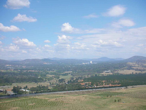
Such garden city concepts influenced Walter Burley Griffin and Marion Mahony Griffin’s design of Australia’s Federal Capital, Canberra. C.R. Scrivener, the surveyor for the site of the new capital, was instructed in 1909 that “the capital should be a beautiful city, occupying a commanding position with extensive views, and embracing distinctive features” (Fizhardinge Citation1954). One of the principal aims in developing the capital as a garden city was to re-establish forest cover on the surrounding hills. Native species were allowed to regenerate on Mount Majura, and were planted (mainly various eucalyptus species) on Mount Mugga and Mount Russell, while conifers were planted on Mount Stromlo (Pryor Citation1954). The city was to be fitted into a striking landscape and that landscape managed so that the hills remained wooded 100 years after it was planned (). The eminent Australian Geographer, Griffith Taylor, studied the topography in 1908, made geological surveys, helping the survey before the plan. He later commented that Canberra was planned according to the best expert principles (Taylor Citation1953).
Figure 1. The Woden Valley area of Canberra showing suburbs hidden by trees surrounded by wooded hills (Photo: Ian Douglas)
Grand schemes: the city beautiful movement in the USA
The first decade of the twentieth century saw both the garden city movement and the larger scale grand city beautiful movement. The city beautiful concept focused on grand boulevards, big vistas, and dominant buildings. This holistic, multipurpose approach to urban planning was applied by Burnham in the redevelopment of the Mall in Washington DC, in plans for Cleveland and San Francisco, but had its greatest impact in Chicago. Even though by the time of the Great Depression in 1929, it became apparent that the city beautiful approach was improving the physical city without addressing serious social and economic issues affecting everyday city life, it continued to affect international views on how to design a great city, especially federal capital cities in large countries (Hall Citation2002). In due course this grand city beautiful view influenced how Ian McHarg saw the possibilities for the federal capital of Nigeria.
At this time the tools of urban planning were being sharpened. Technology made new approaches possible. From the late 19th century, Charles Eliot used a series of overlays to assess how Boston’s left-over land could be developed into a green infrastructure network for the city (Steinitz Citation2008). Around 1910, a colleague of Frederick Law Olmsted, Warren H. Manning took advantage of the availability of electricity to use to use light tables (drawing tables with translucent glass tops illuminated from below) to simplify the tracing of maps of land information and to make overlays to explain ground characteristics for a development and conservation plan for Billerica, Massachusetts (Steinitz Citation2008). These were practical applications of the ecological inspirations for urban planning and design that had been advocated particularly by the biologist, Patrick Geddes, who argued that the development of human communities involved essentially biological problems whose solutions began with a diagnosis of the complex interactions between people, their environments and their activities. Geddes expressed this in terms of place, work and folk. These elements could all be broken down into sets of data, displayed on maps produced as the result of a survey (Osborne and Rose Citation2004).
This survey of the earth science, ecological, land use, and social characteristics of an area became the starting point for strategic and local development planning. By the 1940s, when the Greater London Plan (Abercrombie Citation1944) was prepared, a new school of planners had adopted the idea of the essential preliminary survey and that a plan should be based on scientific principles, finding the most suitable use of each piece of land and then reconciling this with other existing interests (Escritt Citation1943; Ashworth Citation1954). Escritt’s book (Citation1943) is regarded by many as an elegant statement of the fundamental propositions and principles of town and country planning. It tells readers how to make overlays and how to use them to analyze the landscape for particular purposes. The techniques are simple and effective. In 1947, the Labour government took control of planning and quickly implemented an efficient planning system that rebuilt war-damaged cities and created the UK New Towns (Steinitz Citation2008).
In Germany, Reichow (Citation1948) saw that landscape features such as landform configuration, water or vegetation were meant to guide the shape of urban form and to be integrated into a holistic city organism (Lachmund Citation2013). The Kollektivplan, the first master plan for the reconstruction of Berlin after World War II, was explicitly based on city-landscape principles. Designed in 1945–6, it envisioned a radically restructured city of dispersed modernist buildings, clustered into homogeneous neighbor hoods, with wide highway and large green spaces. While the plan ignored the existing historical development, it fitted the city into the regional landscape as dictated by the Spree River and the geomorphology of the river’s basin (Lachmund Citation2013).
Abercrombie (Citation1959) claimed that “no adequate planning scheme can be prepared for a place unless there has been some sort of survey.” His range of topics for the survey () helps to draw attention to the interrelationships between activities and the limitations imposed by environmental factors.
Table 1. List of proposed topics for a preliminary planning survey (adapted from Abercrombie Citation1959)
Many of the basic survey ideas were embedded in the practice of land evaluation. Shortly after the end of the Second World War, the Australian Commonwealth Scientific and Industrial Research Organization (CSIRO) began a series of broad scale integrated land surveys in northern Australia. With the large areas to be covered speed was essential. A technique was devised of using interdisciplinary teams (geologist, geomorphologist, pedologist, plant ecologist), relying heavily on aerial photograph interpretation. These teams surveyed about 125,000 km2 each year mapping (generally at 1:1,000,000) and the members together delimited and described land systems defined as recurring patterns of topography, soils and vegetation (Christian and Stewart Citation1964). Within 15 years the nature and distribution of land types were described in much of the northern part of arid Australia (Perry Citation1977). Urban land suitability mapping was developed by the New South Wales Soil Conservation and was used to guide the planning of residential subdivisions according to landform and drainage characteristics: designing with nature (Hannam and Hicks Citation1980).
Looking back on the development of suburbia in the first half to the twentieth century, Mumford saw elements of designing with nature in the way architects and planners were more scientific and rational than their predecessors (Mumford Citation1961). Abercrombie (Citation1959) emphasized the importance of design in which the claims of natural and artificial promptings are duly respected. Such design considers not only the building, but the uniformity or contrast between natural features and human additions, the siting of buildings, the planting of vegetation and the application of engineering skills. Doxiadis (Citation1968) saw nature as one of a group of five Ekistic elements (along with anthropos (people as individuals), society, shells (buildings) and networks (roads, utilities, transportation, communications and administrative boundaries) in his vision of human settlements as complex social, organic, biological individuals, but not as the same type of organism as those created by nature. McLoughlin (Citation1969) emphasized the need for planners to appreciate the processes of change in the human environment, the underlying reasons for them, their manner of accomplishment, the complex web of interactions between human groups and the need for foresight and guiding change.
The basic principles of designing with nature were thus established and endorsed. Perhaps it was easier to accept them in Europe than in the USA, partly because of the huge desire to build better countries after the social distress of the nineteen thirties and the destruction of the 1939–45 war and the quality of life possible in garden suburbs, monotonous as some them might appear. Clearance of the worst industrial slums was also a major target in the nineteen fifties. People wanted change: not all of them were happy with its results (see for example the convoluted results of post 1945 rehousing and relocation in Manchester, UK in Rodgers Citation1986).
To achieve such concern for landscape protection and good design in America required a bigger jolt. Minds began to be turned by a succession of ideas and well-written books that warned, alarmed and informed people of the need to care for their environment, the fate of the earth and the human population. Lest people think that environmental concern began in the late nineteen sixties, Bennett’s (Citation1939) Soil Conservation, Vogt’s (Citation1948) Road to Survival, and Osborn’s (Citation1948) Our Plundered Planet all took a global view of resource consumption and damage to ecosystems. Osborn and Vogt brought ecological ideas to large popular audiences fifteen years before Rachel Carson’s warning in Silent Spring about the “contamination of man’s total environment” with chemicals (Robertson Citation2012). Their warnings about overpopulation, overconsumption, and environmental degradation pioneered ideas of sustainability that challenged the growth-based economic models then reshaping both American and global landscapes. Perhaps no one brought the themes of Osborn and Vogt together in a more influential way than Paul Ehrlich, author of The Population Bomb (Citation1968), recognizing that population growth and resource depletion had to be managed to achieve greater sustainability: the current (2019) focus of the United Nations Sustainable Development goals, particularly the following:
Goal 1. End poverty in all its forms everywhere
Goal 2. End hunger, achieve food security and improved nutrition and promote sustainable agriculture
Goal 3. Ensure healthy lives and promote well-being for all at all ages
Goal 4. Ensure inclusive and equitable quality education and promote lifelong learning opportunities for all
Goal 5. Achieve gender equality and empower all women and girls
Goal 11. Make cities and human settlements inclusive, safe, resilient and sustainable
These ideas now run through the thinking of most environmental scientists, landscape designers and urban planners. They had a long gestation. Over the decades many people summarized the current state of the art and made new syntheses. Following the publication of insightful books such as Carson’s (Citation1962) Silent Spring and Crowe’s (Citation1956) Tomorrow’s Landscape the scale of the human impact on the environment became increasingly evident and the clamor for political action grew. Crowe (Citation1962) argued that our conception of ecology should include the new complexes that we are creating with our inventions and the human population: an urban ecology. She also said that we must understand ourselves and the civilization for which we are trying to build an environment.
The three years 1969–72 saw major changes in the magnitude of public concern and government action (). This was the context into which McHarg’s book was delivered. People were receptive to new ideas and examples of environmental good practice. It was right book at the right time.
Table 2. Significant Environmental events 1969–72
Like McHarg, McLoughlin (Citation1969) saw Patrick Geddes as an inspiration for planners and stressed the ecological dimensions of urban development and urban activities. He admitted that some would argue that he was making an organic analogy, but recognized that others saw that Geddes was looking at what nature teaches us about human organization and the interdependence of humans, plants and animals in the urban system, or indeed anywhere on earth.
McHarg constantly emphasized the concept of Natural Process: “if growth responds to natural process, it will be clearly visible in the pattern and distribution of development, and, indeed, in its density” (McHarg Citation1969). He and his colleagues understood the relationships among landscape, engineering, ecology, geology and development. They thought that natural processes can guide development. They also argued that several plans should be made for any site and then be compared to help decide which is best. For McHarg, ecological design followed planning and required an intrinsically suitable location, appropriate materials and forms.
At this time, new enthusiasms for using earth-science information in urban planning arose as part of a wider recognition for the need to have good ecological, geological and ground engineering information for successful urban development. The US Geological Survey produced examples of its use of landform, geology, surface materials, sub-crop, slope stability, hydrology and land capability in the planning of new urban area such as Franconia Virginia (Robinson and Speiker Citation1978). The resources survey of Bahrain (Brunsden, Doornkamp, and Jones Citation1979) demonstrated the value of such mapping in planning an expanding city in an arid region, particularly the importance on understanding slope stability and ephemeral drainage lines.
McHarg’s legacy internationally: planned towns and capital cities
McHarg and his colleagues advised many urban authorities in the US and around the world. In the 1950’s he was part of a team planning the new towns around Glasgow, Scotland (Warnop Citation1986). One of his assignments was to look for a good site for a new town east of Glasgow. He found that an outstanding hill., with a south-easterly aspect would provide a wonderful opportunity to build a prominent and different type of new town. He had a special admiration for the monumental city, shown later in his work on Washington, but already in his notes on this site he made comparisons with the sites of Athens, Greece and Edinburgh, Scotland. The town eventually built, Cumbernauld, did indeed have monumental structures, but some would have called them “brutalist” (Gold Citation2006). This was the time when Le Corbusier was in fashion and concrete tower blocks for social housing were being built by local authorities. McHarg’s sketches of what would be possible at the Cumbernauld site indicated he thought large buildings would be appropriate for that site (Wightman Citation2014).
In complete topographic contrast, one of his most successful projects was at Woodlands, north of Houston in Texas, a planned community that remains well forested up to the present day. Its site differed greatly from the high relief of places like Cumbernauld in Scotland or Abuja in Nigeria where McHarg envisaged cities on or between hills. Here the floodplains of rivers need careful treatment, with space for water being essential (McHarg Citation1996). It is generally accepted in all writing about urban greening and urban forestry that McHarg’s type of landscape ecological principles should be employed as a key part of the design process (Bell et al. Citation2005). There are thus contrasts in three things that McHarg emphasised: the deigning with nature (the fitting of buildings into the existing landscape and leaving space for water and nature); the siting of cities to take advantage of prominent landforms and thus add to built monumentalism (as potentially in Cumbernauld and operationally in Abuja); and building cities fit for the people of the locality. All three concepts influence his work at different locations and times. To examine how far those influences have extended and how well it they have worked, I will look at some newly planned cities, beginning with Milton Keynes in the UK and mining towns in arid regions, and subsequently at the contrasting motivations in the designs for new capital cities.
Milton Keynes: avoiding the mistakes of the earlier UK new towns?
McHarg’s ideas did not permeate far enough into the planning of England’s largest new urban settlement, Milton Keynes, built approximately halfway between Birmingham and London on the country’s busiest main railway line. The location for the new city was chosen on economic, political and social grounds. Anxious to avoid some of the perceived mistakes in the planning of the earlier post-1945 new town in the UK, the Corporation set in place grid roads running between districts, a system of independent cycle/pedestrian paths, known as the Redway system, and intensive planting, lakes and parkland. The radical grid plan was inspired by Melvin Webber who thought that telecommunications meant that the old idea of a city as a concentric cluster was out of date and that cities that enabled people to travel around them readily would be the thing of the future (Webber Citation1963). At a time when barely half of all British households owned a car, it was an audacious vision, and although Milton Keynes became the town that many planners loved to hate, most of its citizens praise the quality of life there. The plan took note of some natural assets by enabling the gravel deposits in the River Ouzel valley to be worked before development started; recognizing the need to allow brick clay working for the existing industry in the area; and devising a solution for storm water drainage (Architects’ Journal Citation1969).
However, there was not the detailed consideration of the environment in to which the new town was being put. An example is provided by the lack of earth-science mapping of the type advocated by Robinson and Speiker (Citation1978) prior to setting out the plan. The new town site was designated in 1965. The geological survey was started in 1961, but the bulk of the work was undertaken after the designation of the new town, with a draft map being published in 1968 (Horton, Shephard Thorn, and Thurrell Citation1974). Fairly extensive pilot studies were carried out, albeit started at a late stage, perhaps too late to influence planning (Cratchley and Denness Citation1972). Information from the whole investigation has been presented on an engineering geological base map accompanied by a series of overlays, a table of measured geotechnical properties and interpreted behavioral characteristics, and a detailed explanatory report which includes adequate baseline geological information to avoid the hazards posed by the characteristics of the site. Base maps on a 1:25,000 scale were available for the complete area and at 1:10,000 for presentation of more detailed data on the superficial deposits of the Ouzel Valley. Advice was given on the existence of running sands, laminated lake sediments and their probable effects on the excavation of the main drainage channel, on conditions along alternative trunk sewer routes, and of problems of differential settlement on glacial till Cratchley and Denness (Citation1972).
Cratchley and Denness (Citation1972) also pointed out that engineering geological evaluation had seldom been used in the general planning and detailed siting of existing new towns, and in particular they have remarked on the late stage at which it was started at Milton Keynes. Thirty years later it was recognized that the Milton Keynes engineering geological mapping project had provided valuable experience and lessons for future similar studies. Importantly, the study enabled the Engineering Geology Unit of the British Geological Survey to develop the principles on which later engineering geological maps were produced and highlighted the need for good subsurface data.
By 1974, the case was being made by leading geologists and engineers for the increased use of engineering geological maps and plans in urban situations by planners and others concerned with urban development. In future, they foresaw that the appropriate government agencies may require mandatory maps and plans to be produced for certain types of planning and development. (Dearman and Fookes Citation1974).
The design of Milton Keynes took inspiration from towns in the Netherlands that adopted a naturalistic approach to landscaping, using native species in housing areas. The chief architect and Planner of the city, Derek Walker reputedly said that Milton Keynes would be “greener than the countryside around it.” The aim was to lose the city in a re-created forest (Walker Citation1981). The Development Corporation’s foresters planted millions of trees from its own nursery and by 2006 the urban area has 20 million trees. It was provided with designed nature, rather than being designed with nature. Good landscape design led to the creation of a new environment, modifying former farmland and clay pits to create woodlands, wetlands and parks. The plan left 40 per cent green space within the city, and two valleys as linear parks with lakes to hold floodwater – a water-management system which looks far-sighted in an era of climate change. 10 years after the first new residents moved into Milton Keynes, respondents to a survey were generally positive about the “countryside” and the footpaths and trees in their new environment ( and ). They enjoyed using the landscaped, winding, Redway paths for both leisure and purposeful journeys (Bishop Citation1986). Eventually the greenspaces were handed over to The Parks Trust, an independent, self-financing charity in Milton Keynes, which is endowed with a portfolio of commercial properties, the income from which pays for the upkeep of the green spaces, a citywide maintenance model which has attracted international attention.
Figure 2. Milton Keynes: runners using a redway passing under a road bridge (Photo courtesy of The Parks Trust, Milton Keynes)
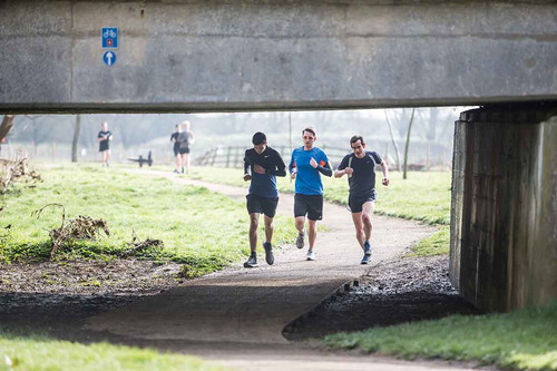
Figure 3. Milton Keynes: features in a park connected to the redway system (Photo courtesy of The Parks Trust, Milton Keynes)
While Milton Keynes could be considered a success in terms of an ill-defined “sustainability:” with considerable of biomass and urban wildlife and excellent cycling facilities, its design as built does not “sustain” local shops or other services as well as it should; it does not support public transport use, but fosters a car-dependent way of life (Edwards Citation2001). In a way, it is an example of creative conservation: putting nature into the city rather than working with pre-existing nature.
Planning of desert cities
Fitting new urban settlements into arid landscapes also requires the use of McHarg’s methods of ecological suitability analysis of land use through analysis of ecology, earth science, systems science, environmental science and detailed mapping (now employing GIS) (Mahmoud and El-Saye Citation2011). In planning mining towns in arid regions, while water is a priority concern, attention has to be given to the setting, to landscaping in harmony with the surroundings, to use of native species in greenspaces, and to the visual and social cohesiveness of the urban settlement (Calderbank Green Citation1982). The town of Shay Gap and Marandoo in the Pilbara region of Western Australia both show indirect applications of McHarg’s ideas, having both been well fitted into the site and making adaptions to the harsh environment. However, in the case of Nhulunbuy at the remote Australian Gove Peninsula former aluminum smelter location, good site investigation and ecological design failed because Nhulunbuy was designed to provide a middle-class suburban standard of living with an “equivalent quality to project builder’s homes in southern capitals” and a climate controlled environment that did not respond to the surrounding tropical context at all (Robertson Citation2016).
Construction of the town occurred before the 1976 Aboriginal Land Rights (Northern Territory) Act and the needs of the local people were not adequately considered. The Act allowed some local communities to receive mining royalties and the Gumatj and Rirratjingu Aboriginal Corporations subsequently led two major building initiatives resulting housing and community buildings which were environmentally responsive and supportive of local people (Robertson Citation2016). This type of situation where plans are developed with thorough site investigation and a good degree of designing with nature but later are found not to meet community needs recurs in several locations. McHarg (Citation1969) fully recognized that the task of planning is to maintain and enhance the conditions providing for health and well-being. Just as Australian planners recognized that mining town development could not be left to mining engineers, McHarg frequently emphasized that “Planning for the human environment must be more encompassing than the narrow role now employed in city planning and, indeed, by ecological planners.” The lessons from small desert towns may also have be to learnt and applied those whose aim to design new garden cities and planned capital cities with nature.
The garden city models of new capital cities
Many modern new capital cities and national administrative centers follow the garden city model. Whether they had the detailed survey and layers of information that Ian McHarg advocated is unclear. However, many, like Canberra, retain natural woodland and have artificial lakes and associated wetlands.
When Brasilia was being planned in 1956, the Commission for Planning, Building and Moving the Federal Capital made available data about the Federal district including soils, climate, groundwater, surface, land capability for agriculture, some in the form of overlays (Hall Citation2002). At the time, city planning and design was dominated by architectural considerations. Planners were often poorly aware of the social, cultural and economic implications of their responsibilities.
Abuja, Nigeria
McHarg was involved in planning the new Nigerian Federal Capital Abuja, working in 1978 on the site evaluation and selection and the technical review. In June 1977, the Federal capital development Authority of Nigeria commissioned the International Planning Association (IPA) consisting of three US firms, including McHarg’s company, WRMT, produce a Master Plan for the new Federal Capital (Morris Citation2009). WRMT created a distinctive identity for the city through site selection and detailed design of the Central Area, which contains the national Government Center, national cultural institutions, and the central business district. WRMT was chosen by the Nigerian government partly because of their work in Washington D.C.
The preliminary survey using ecological planning tools, Report No. 2: Site Evaluation and Site Selection (Citation1968), which was led by McHarg, was crucial in deciding how Abuja would be formed (Morris Citation2009). The Gwagwa Plains within the Federal Capital Territory were chosen as the location of Abuja because of their ecology, the dominant park savanna vegetation being seen as ideal for a Capital City landscape. Riverine complex and rainforest provided opportunities for natural erosion control, buffer zone, and limited timber and fuel. The IPA determined that the best way to ensure the future sustainability of the city was to preserve the existing stream valleys with the Aso Rock, a 400 meters high prominent monolith with a peak height of 936 meters above sea level, as the focal point in the city layout, following McHarg’s ecological planning principles. It flanks the city in a similar way the Parthenon overlooks Athens.
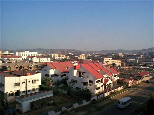
Although Aso Rock is imposing and beautiful, before Abuja’s creation it held little meaning to the average Nigerian. McHarg’s choice of Aso Rock as a symbol of the capital was a preservation tactic. While Aso Rock lies within the city boundary, the terrain around it is unsuitable for building. Altogether 32% of the land in Abuja was kept for open space and parks, a great contrast to land use in most African cities. However, the master plan foresaw a population of 1.5 million but by 2009 there were 6 million people living in Abuja and adjacent urban settlements. The implantation of the master plan, which envisaged the building of one residential area and then another, ran into problems with a promise that all citizens could be stakeholders with access to land in the federal capital (Wuyep Citation2009). The original villagers on the site were relocated to other areas and into housing with which they were unfamiliar (). Many sold those dwellings and eventually technically became squatters on their own land, as their fathers’ lands had been sold to others. The complex land tenure situation and the great growth in population, coupled with many political changes and shifts in government priorities, has made the realization of the plan difficult (Morris Citation2009).
Figure 4. Abuja: housing below the protected surrounding hills, illustrating both the planning goal of fitting the city into the landscape and domestic buildings that may not be ideal for the African environment (photo Ian Douglas)
Critics claim that McHarg used his ecological planning principles to import an ideology that is foreign to most Nigerians. Therefore, the very notion that Abuja’s master plan should fit within their larger body of work implies a bias for western planning and a disregard to how Nigerians live (Tobin Citation2017). The physically sound master plan, created through ecological planning, was ill-equipped to provide for a nation undergoing post-conflict rebuilding, rapid population growth and complex land tenure difficulties.
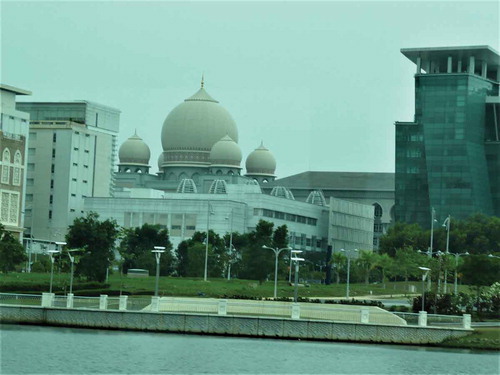
Putrajaya, Malaysia’s new administrative capital
The planning of Putrajaya emphasized the physical aspects, such as landform, vegetation, visual quality and water bodies. The thinking behind its design had the objective of creating a balance between physical development and human development in terms of spiritual and noble universal values for the sustainable progress of the country (Omar Citation2004). The doctrine has given rise to new emphasis on planning practice and it sets out guidelines in physical planning terms. Putrajaya is a plan driven city based on two underlying concepts, the city in the garden and the intelligent city. However, its emphasis on environmental conservation, on attractive landscape and on equitable access to open greenspaces contains many elements of designing with nature. The adoption of these concepts to guide its physical development was aimed at a balanced and sustainable development, environmentally socially, as well as economically. The Integration of metropolitan parks such as Taman wetlands and botanical garden with other urban and pocket parks will function as green lung for the city. In line with the garden city concept, more than a third of the total area (37.6%: 1,722 ha) is kept as open space. Despite applying concepts from New Urbanism’s emphasis on dense building and walkability Putrajaya is still relatively low density; it is a long, hot walk to get anywhere; and there are no shade trees provided for pedestrian movement (Qureshi and Ho Citation2011).
The layout of the core area resembles a formal axis punctuated with nodal features and identifiable precincts. The peripheral area of Putrajaya is mostly residential, with a projected total of 67,000 housing units catering for residents of various income levels. The residential concept of Putrajaya aims to nurture a sense of identity among the community through the establishment of neighborhood focal points, public realm and landscaping (). However, although Putrajaya’s administration talks about the walkable city as part of its sustainability goals, the suburbs and road lay outs lack the pedestrian friendliness that the Redway paths and cycle routes have created in Milton Keynes. Whether Putrajaya has created a truly habitable environment for people remains to be demonstrated (Lee et al. Citation2006).
Figure 5. Putrajaya: Government buildings with integrated landscaping by the lake in the administrative center (photo Ian Douglas)
Naypyidaw, Myanmar’s security conscious federal capital
The geographical terrain of the city comprises green fields along the Ngalaik canal and steep slopes with small hills surrounded by the Pegu Yoma range to the west. The mixture of river plains and mountains covered by green forests is an excellent geographical location which offers every advantage of beauty and peace that a city-builder could desire. Although there are grid-like streets, especially in residential-commercial areas, the general layout of the city follows the contours of the land, especially in the area where the government buildings have been constructed (Seekins Citation2009). The government has artificially transformed the landscape of Naypyidaw into a beautiful and magnificent capital by grouping bureaucratic buildings, and constructing new roads, roundabouts and shopping complexes and digging many artificial lakes. However, the heart of Myanmar’s bureaucracy, in northern Naypyidaw, is akin to a suburban office park. Fifty-one identical two-story office buildings housing the staff of thirty-six ministries are each perched at the end of individual driveways branching from a six-lane highway that winds through rolling hills covered in dense vegetation (Dulyapak Citation2009, Citation2011; Pardee Citation2017).
This compartmentalized city appears to be determined to hold the state at arm’s length from its citizens. Separated by kilometers of golf courses, lush jungle, and rice paddies, these enclaves appear less as a cohesive city and more as a series of figures on a blank map, bound together only by a network of modern motorways. Although worthy of architectural attention and analysis, further investigation of Naypyidaw reveals a dense web of narrative and security parameters working in tandem to produce an authoritarian ecosystem. One commentator declared “Burma’s new capital is ‘dictatorship by cartography’” (Ford Citation2014).
Contrasts in capital objectives and achievements
Abuja, Putrajaya and Naypyidaw all show good elements of site selection and planning. The grandeur of major avenues or malls is present with prominent seats of government, but the political dimensions are also starkly evident, particularly in Naypyidaw. Although it is always likely than a capital city will have a social gulf between the powerful governing elite and the residents who had always lived in and around the chosen site or the low-income workers engaged in service industries supporting government activities, such gulfs are often particularly marked where different tribal and ethnic groups are involved. In Abuja, the housing and land tenure crises caused by a far faster population growth than the master plan anticipated has led to dissatisfaction and disruption. In Putrajaya sustainable urban development was intended, but plans for walking and cycling have failed, due to the wide separation of facilities, homes and workplaces. In Naypyidaw, the government’s obsession with security has made urban mobility and social integration extremely difficult. They illustrate that no matter how good the ecological planning and designing with nature may be, planned cities may not always work.
Designing with nature in modern cities
Designing with nature has become a key tenet of some forms of urban design. However, sometimes the value of the designing is not always fully recognized and made use of by the occupants of the dwellings in the new settlement or subdivision. The key to capturing the wellbeing benefits of vegetation is to have frequent green spaces interwoven into the city, including private gardens, communal gardens and well-overlooked public spaces between blocks, located where people really need them and frequent them. Beauty really matters. Any development that most people find esthetically acceptable may fail to maximize the wellbeing of residents. For many, the issue is whether the beauty is totally newly created, with the site initially cleared and subsequent post-construction development of gardens and street trees, open spaces and artificial wet lands (perhaps expected in a garden city), or whether the beauty comes from, at least in part, retaining as much of the original natural (or former rural) landscape as possible by fitting the development into the landscape and preserving some natural or remnant woodlands and wetlands (designing with nature).
There is a major question about desirable density and housing form. McHarg’s ideals seem to favor low density, but today there is pressure for higher densities and spaces between blocks that may favor greater community interaction. But in a century where more time is spent on electronic social media than meeting people face to face, we need to question how far urban design should continue to emphasize the advantages of urbanity and suburbanity, of space and of connectivity. Nevertheless, the garden city concept is still advocated in some quarters. The UK Government announced a new Garden Communities Programme for “vibrant, mixed use, communities where people can live, work, and play for generations to come – communities which view themselves as the conservation areas of the future” (Ministry of Housing and Local Government Citation2018). The prospectus refers back to Ebenezeer Howard’s ideals, but the communities so far announced are located on the peripheries of existing urban areas.
The mapping advocated by McHarg is still needed to provide the comprehensive knowledge of the urban system required to establish clear guidance and targets, especially the links between socioeconomic driving forces, the functioning of the urban system and its environmental performance (Pauleit and Duhme Citation2000). GIS has transformed the mapping exercises and makes rapid revision to account for changes in land use and land cover possible. However, there is a temptation simply to map from previous data bases and satellite imagery without walking over the ground and noticing what is happening in detail. Field survey remains an important preparatory step in land use planning.
Twenty-first century perspectives on McHarg’s legacy
McHarg’s vision of the nature of urban areas consistently advocated single family housing with large house plots. For example, in his plan for Medford, New Jersey, single- family residences on lots of over 0.4 ha were considered the best type of new residential development (Cohen Citation2003). Although changed in later decades, the Medford project was possibly one of the greatest achievements of the team of staff and students he led at the Center for Ecological Research in Planning and Design, University of Pennsylvania In his autobiography, McHarg (Citation1996) said that “it became the bible for the township and remains so to this day.” It affected the creation of the Pinelands Preserve, was a model for the 1990 New Jersey State Plan, and was employed as the basis for many other studies (McHarg Citation1974).
Throughout Design with Nature, McHarg (Citation1969) advocated the spacious countryside and its scenic qualities over denser, urban living. In the early 21st century, most cities have a shortage of new land for housing and competition for space for urban food growing and for nature and recreation. Many argue for greater compaction of living space to permit greater provision of public parkland and open space. Some ask whether urban expansion (“sprawl”) should continue to be restricted in order to preserve rural landscapes, even when these are factory-farmed as a form of virtual monoculture, maintained by massive application of artificial chemicals (Haughton Citation2007).
McHarg’s designs in his 1969 book often were for new urban settlements to be fitted into the countryside. Yet some of the interpretations of his ideas would be better described as “retrofit with nature;” reintroducing nature into existing towns and cities. One example cited by Asian writers is the way in Utrecht and Delft in the Netherlands, nature-imitating features (logs, stones, wild roses) were landscaped around office and housing blocks (Wong and Yuen Citation2011). Naturalistic gardens and parks have become increasingly familiar to urban people in Europe.
While the ecological principles and methods of McHarg’s system are admirable, the allocation of future land uses has to be made on more criteria other than land capability alone. Thus, some of McHarg’s diagrams of possible settlements appear utopian or seems imposed. In the end, all allocations are made with respect to human values, not with respect to natural values, even though people cannot afford to ignore nature if they are to secure their own human values (Gold Citation1974). As the cities discussed earlier demonstrate, the question is whose human values; the government’s, the land owner’s, the local communities’, the landscape and planning professional’s, or the developer’s?
Urban designers need to be aware of the many different approaches diverse people have to urban areas and their environment. Moudon (Citation1992) lists nine areas of concentration that encompass research that is of value in urban design (). They indicate the possible existence of silos of landscape knowledge with McHarg being a pioneer and leader of the nature-ecology area. However, the reality is that we now know that the landscape architect has to be an artist, a designer and a planner working in a holistic discipline applying urban ecology in its widest sense (Weller and Fleming Citation2016).
Table 3. Areas of concentration in urban design (after Moudon Citation1992)
Another commentary on McHarg’s influence considers whether he always wanted to restore some kind of pre-existing nature by restoring ecological functions by using native flora and fauna as the authentic nature to restore in the city (Herrington Citation2010). Although now the subject of fervent debate in countries such as Australia and New Zealand (Meurk Citation2011), the advent on novel ecosystems (Hobbs et al. Citation2006) embracing invasive species and introduced plants, creates new urban opportunities. However, it may lead to biotic homogenization that threatens to reduce the biological uniqueness of local ecosystems (McKinney Citation2002).
Most people perceive nature in the urban landscape filters created by concepts that prejudge its ecological and cultural value. People often use convenient local open spaces that may not be rich in biodiversity and contain a mix of native and exotic species because such places ae convenient accessible and familiar. Different groups may use such places for different purposes at different times of the day. Each individual finds value there, but the values differ for social and cultural reasons.
Since McHarg (Citation1969) wrote, the discourse about urban nature has changed. In the 1970s there was still a dominant view that nature was something to conquer, command and control., but increasingly urban nature is now seen as something generally friendly, familiar and yet sometimes fantastic, such as deer in city streets, flocks of parakeets flying overhead and seagulls massing around uncovered landfill material. Perhaps a key indicator how well the ideas advocated by McHarg have been accepted and become normal is the urban discourse is a diagram of principles of city design in the April 2019 edition of National Geographic (p.22) which states: “Ecology: the future city is designed around natural features and forces, protecting wildlife habitat and natural resources. Based on a unified vision for the region, the city is compact and dense to limit impacts on the ecosystem.” The first sentence is pure McHarg. The second is perhaps counter to his general view of the garden city approach to residential developments.
In urban environmental and ecological matters, we now see the convergence of the sciences in action (Watson Citation2016). Teams of diverse professionals from the ecological and sciences, engineers, architects, planners and landscape designers, artists, social scientists and economists all working together to achieve resilient, sustainable, liveable cities the work for people and nature in harmony are now operating in the way McHarg argued they should (McHarg Citation1988). These teams have to engage with communities and politicians to ensure that planning policies and government subsidies support such approaches to urban development and go beyond piecemeal actions, such as requiring sustainable urban drainage (‘best practices’) without requiring permeable pavements for parking lots and preventing unnecessary paving of front gardens (“yards”) and managing storm sewer overflows. The integrated thinking advocated by McHarg is sometimes in short supply in local practice.
Disclosure statement
No potential conflict of interest was reported by the author.
Related Research Data
References
- Abercrombie, P. 1944. Greater London Plan. London: University of London Press.
- Abercrombie, P. 1959. Town and Country Planning. 3rd ed. London: Oxford University Press.
- Architects’ Journal. 1969. “AJ Archive: Milton Keynes Planning Study.” Accessed 27 March 2019. https://www.architectsjournal.co.uk/news/culture/aj-archive-milton-keynes-planning-study-1969/10016661.article
- Ashworth, W. 1954. The Genesis of Modern British Town Planning. London: Routledge &Kegan Paul.
- Bell, S., D. Blom, M. Rautamäki, C. Castel-Branco, A. Simson, and I. A. Olsen. 2005. “Design of Urban Forests.” In Urban Forests and Trees: A Reference Book, edited by C. C. Konijnendijk, K. Nilsson, T. B. Randrup, and J. Schipperijn, 149–186. Berlin: Springer.
- Bennet, H. H. 1939. Soil Conservation. New York: McGraw-Hill.
- Beveridge, C. E., and P. Rocheleau. 1998. Frederick Law Olmsted: Designing the American Landscape. New York: Universe Publishing.
- Bishop, J. 1986. Milton Keynes – the Best of Both Worlds? Public and Professional Views of a New City (occasional Paper 24). Bristol: University of Bristol, School of Advanced Urban Studies.
- Brunsden, D., J. Doornkamp, and D. K. C. Jones. 1979. “The Bahrain Surface Materials Resources Survey and Its Application to Regional Planning.” The Geographical Journal 145 (1): 1–35. doi:10.2307/633073.
- Calderbank Green, H. 1982. “Town Design in the Arid Pilbara of Western Australia.” In Desert Planning: International Lessons, edited by G. Golany, 15–30. London: Architectural Press.
- Carson, R. 1962. Silent Spring. New York: Houghton Mifflin.
- Christian, C. S., and G. A. Stewart. 1964. “Methodology of Integrated Surveys.” Conference on Principles and Methods of Integrated Aerial Survey Studies of Natural Resources for Potential Development. Paris: U.N.E.S.C.O.
- Cohen, W. J. 2003. “A Critical Assessment of Ian McHarg’s Human Ecological Planning Curriculum at the University of Pennsylvania.” Publicly Accessible Penn Dissertations. 3087. https://repository.upenn.edu/edissertations/3087
- Cratchley, C. R., and B. Denness. 1972. “Engineering Geology in Urban Planning with an Example from the New City of Milton Keynes.” International Geological Congress, 24th Session, Montreal. Section 13 Proceedings:13–22.
- Crowe, S. 1956. Tomorrow’s Landscape. London: Architectural Press.
- Crowe, S. 1962. “Civilization and Landscape.” Journal of the Royal Society of Arts 110 (5066): 93–102.
- Dearman, W. R., and P. G. Fookes. 1974. “Engineering Geological Mapping for Civil Engineering Practice in the United Kingdom.” Quarterly Journal of Engineering Geology and Hydrogeology 7: 223–256. doi:10.1144/GSL.QJEG.1974.007.03.01.
- Doxiadis, C. 1968. Ekistics: an Introduction to the Science of Human Settlements. New York: Oxford University Press.
- Dulyapak, P. 2009. Naypyidaw the New Capital of Burma. Bangkok: White Lotus.
- Dulyapak, P. 2011. “Myanmar’s New Capital City of Naypyidaw.” In Engineering Earth, edited by S. Brunn, 1021–1044. Dordrecht: Springer.
- Edwards, M. 2001. “City Design: What Went Wrong at Milton Keynes?” Journal of Urban Design 6 (1): 73–82. doi:10.1080/13574800120032905.
- Ehrlich, P. 1968. The Population Bomb. New York: Buccaneer Books.
- Escritt, L. B. 1943. Regional Planning: an Outline of the Scientific Data Relating to Planning in Great Britain. London: Allen & Unwin.
- Fizhardinge, L. F. 1954. “In Search of a Capital City.” In Canberra: a Nation’s Capital, edited by H. L. White, 3–13. London: Angus & Robertson.
- Ford, M. 2014. “A Dictator’s Guide to Urban Design.” Accessed 26 March 2019. https://www.880cities.org/images/resource/park-space-arti/a-dictators-guide-to-urban-design.pdf
- Gold, A. J. 1974. “Design with Nature: A Critique.” Journal of the American Institute of Planners 40 (4): 284–286. doi:10.1080/01944367408977481.
- Gold, J. R. 2006. “The Making of a Megastructure: Architectural Modernism, Town Planning and Cumbernauld’s Central Area, 1955–75.” Planning Perspectives 21: 109–131. doi:10.1080/02665430600555255.
- Hall, P. 2002. Cities of Tomorrow. Third ed. Blackwell: Oxford.
- Hannam, I. D., and R. W. Hicks. 1980. “Soil Conservation and Urban Land Use Planning.” Journal of the Soil Conservation Service of NSW 36: 134–145.
- Haughton, G. 2007. “In Pursuit of the Sustainable City.” In Scaling Urban Environmental Challenges, edited by P. J. Marcotullio and G. McGranahan, 274–290. London: Earthscan.
- Herrington, S. 2010. “The Nature of Ian McHarg’s Science.” Landscape Journal 29: 1–10. doi:10.3368/lj.29.1.1.
- Hobbs, R. J., S. Srico, J. Aronson, J. S. Baron, P. Bridgewater, V. A. Cramer, P. R. Epstein, et al. 2006. “Novel Ecosystems: Theoretical and Management Aspects of the New Ecological World Order.” Global Ecology and Biogeography 15 (1): 1–7. doi:10.1111/j.1466-822X.2006.00212.x.
- Horton, A., E. R. Shephard Thorn, and R. G. Thurrell. 1974. “The Geology of the New Town of Milton Keynes: Explanation of 1:25,000 Special Geological Sheet SP83 with Parts of SP73, 74, 84, 93 and 94”. Report of the Institute of Geological Sciences, No. 74/16.
- Knox, P. 1987. Urban Social Geography: An Introduction. 2nd ed. Harlow: Longman.
- Kowarik, I. 2011. “Novel Urban Ecosystems, Biodiversity and Conservation.” Environmental Pollution 159 (8–9): 1974–1983. doi:10.1016/j.envpol.2011.02.022.
- Lachmund, J. 2013. Greening Berlin: the Co-production of Science, Politics and Urban Nature. Cambridge MA: MIT Press.
- Lambrechts, A. 2000. “Les Cités Jardins en Belgique.” Ciudades 6: 57–74.
- Lee, L. M., A. Aldrin, S. F. Tan, B. Nurwati, and S. H. Ahmad. 2006. “How We Failed to Plan for Habitability.” Planning Malaysia: Journal of the Malaysian Institute of Planners 4: 1–21.
- Loram, A., K. Thompson, P. H. Warren, and K. J. Gaston. 2008. “Urban Domestic Gardens (XII): the Richness and Composition of the Flora in Five UK Cities.” Journal of Vegetation Science 19 (3): 321–330. doi:10.3170/2008-8-18373.
- Mahmoud, A. H. A., and M. A. El-Saye. 2011. “Development of Sustainable Urban Green Areas in Egyptian New Cities: the Case of El-Sadat City.” Landscape and Urban Planning 101: 157–170. doi:10.1016/j.landurbplan.2011.02.008.
- McHarg, I. 1968. “Ecology for The Evolution of Planning and Design.” VIa 1: 44–67.
- McHarg, I. 1969. Design with Nature. Garden City NY: Doubleday.
- McHarg, I. 1974. “Introduction.” In Medford: Performance Requirements for the Maintenance of Social Values Represented by the Natural Environment of Medford Township, edited by N. Juneja, 3. Philadelphia: Center for Ecological Research in Planning and Design, University of Pennsylvania.
- McHarg, I. 1988. “Ian McHarg on City Planning.” Berkeley Planning Journal 3 (2): 34–54.
- McHarg, I. 1996. A Quest for Life: an Autobiography. London: Wiley.
- McKinney, M. L. 2002. “Urbanization, Biodiversity, and Conservation.” Bioscience 52 (10): 883–889. doi:10.1641/0006-3568(2002)052[0883:UBAC]2.0.CO;2.
- McLoughlin, J. B. 1969. Urban and Regional Planning: a Systems Approach. London: Faber.
- Meurk, C. D. 2011. “Recombinant Ecology of Urban Areas: Characterisation, Context and Creativity.” In The Routledge Handbook of Urban Ecology, edited by I. Douglas, D. Goode, M. E. Houck, and R. S. Wang, 198–220. London: Routledge.
- Ministry of Housing and Local Government. 2018. Garden Communities. London: Ministry.
- Morris, E. S. 2009. “Abuja Plans for the Environment and Development: Reviewing the Master Plan for Abuja, Nigeria 1977–2003.” Human Ecology: The Commonwealth Human Ecology Council Journal 21/22: 20–23.
- Moudon, A. 1992. “A Catholic Approach to Organizing What Urban Designers Should Know.” Journal of Planning Literature 6 (4): 331–349. doi:10.1177/088541229200600401.
- Mumford, L. 1961. The City in History: Its Origins, Its Transformations, and Its Prospects. London: Secker and Warburg.
- Omar, D. B. 2004. “The Total Planning Doctrine and Putrajaya Development.” In The Sustainable City III, edited by N. Marchettini, C. A. Brebbia, E. Tiezz, and L. C. Wadhwa, 81–90. Southampton: WIT Press.
- Osborn, F. 1948. Our Plundered Planet. London: Faber and Faber.
- Osborne, T., and R. Rose. 2004. “Spatial Phenomenotechnics: Making Space with Charles Booth and Patrick Geddes.” Environment and Planning D: Society and Space 22: 209–228. doi:10.1068/d325t.
- Pardee, G. 2017. “Auspicious Urbanisms: Security and Propaganda in Myanmar’s New Capital.” Avery Review 24. Accessed 04 March 2019. http://averyreview.com/issues/24/auspicious-urbanism
- Pauleit, S., and F. Duhme. 2000. “Assessing the Environmental Performance of Land Cover Types for Urban Planning.” Landscape and Urban Planning 52: 1–20. doi:10.1016/S0169-2046(00)00109-2.
- Perry, R. A. 1977. “The Evaluation and Exploitation of Semi-arid Lands: Australian Experience.” Philosophical Transactions of the Royal Society London. B 278: 493–505. doi:10.1098/rstb.1977.0057.
- Pietrusiak, P. 2004. “The Local Philanthropy of the Reckitt Family, with Particular Reference to Hull Garden Village.” Quaker Studies 8 (2): 141–171. http://digitalcommons.georgefox.edu/quakerstudies/vol8/iss2/4
- Pryor, L. D. 1954. “Landscape Development.” In Canberra: a Nation’s Capital, edited by H. L. White, 221–223. London: Angus & Robertson.
- Qureshi, S., and C. S. Ho. 2011. “Towards Putrajaya Green City 2025: Implementing Neighbourhood Walkability in Putrajaya.” Paper 1-7-4 Presented at the 2011 APSA Congress, Seattle. Accessed 25 March 2019. http://asialeds.org/sites/default/files/resource/file/Towards-Putrajaya-Green-City-2025-Implementing-Neighbourhood-Walkability-In-Putrajaya.pdf
- Reichow, H. B. 1948. Organische Stadtbaukunst: Von der Großstadt zur Stadtlandschaft. Berlin: Westermann.
- Robertson, H. 2016. “All that Glitters Is Not Gold: the Effect of Mining Activities and Royalties on the Built Environment of Remote North East Arnhem Land.” Proceedings of the Society of Architectural Historians, Australia and New Zealand:33, Gold, edited by A. M. Brennan and P. Goad, 578–590.
- Robertson, T. 2012. “Total War and the Total Environment: Fairfield Osborn, William Vogt, and the Birth of Global Ecology.” Environmental History 17 (2): 336–364. doi:10.1093/envhis/ems020.
- Robinson, G. D., and A. M. Speiker, eds. 1978. “’Nature to Be Commanded….’: Earthscience Maps Applied to Land and Water Management.” US Geological Survey Professional Paper 950.
- Rodgers, B. 1986. “Manchester: Metropolitan Planning by Collaboration and Consent; or Civic Hope Frustrated.” In Regional Cities in the U.K. 1890–1980, edited by G. Gordon, 41–58. London: Harper & Row.
- Seekins, D. M. 2009. “’Runaway Chickens’ and Myanmar Identity.” City 13 (1): 63–70. doi:10.1080/13604810902726202.
- Steiner, F., Thompson, G. and A. Carbonell,eds. 2016. Nature & Cities. Cambridge, MA: Lincoln Institute of Land Policy.
- Steinitz, C. 2008. “Landscape Planning: A Brief History of Influential Ideas.” Journal of Landscape Architecture 3 (1): 68–74. doi:10.1080/18626033.2008.9723397.
- Taylor, G. 1953. “Urban Geography.” In Geography in the Twentieth Century, edited by G. Taylor, 500–527. London: Methuen.
- Taylor, H. A. 1995. “Urban Public Parks, 1840–1900: Design and Meaning.” Garden History 23 (2): 201–221. doi:10.2307/1587078.
- Tobin, T. 2017. “Nationalism Can’t Be Built: The Story of Abuja’s Creation,” Thesis, Georgetown University https://repository.library.georgetown.edu/bitstream/handle/10822/1043703/Tobin_HIST409_Thesis.pdf?sequence=1
- Vogt, W. 1948. Road to Survival. New York: William Sloan.
- Walker, D. 1981. The Architecture and Planning of Milton Keynes. London: Architectural Press.
- Warnop, U. 1986. “Glasgow/Clydeside: a Century of Metropolitan Evolution.” In Regional Cities in the U.K. 1890–1980, edited by G. Gordon, 82–98. London: Harper & Row.
- Watson, P. 2016. Convergence. London: Simon and Schuster.
- Webber, M. M. 1963. “Order in Diversity: Community without Propinquity.” In Cities and Space, edited by L. Wingo, 25–54. Baltimore, MD: Johns Hopkins Press.
- Weller, R., and B. Fleming. 2016. “Has Landscape Architecture Failed? Reflections on the Occasion of LAF’s 50th Anniversary.” Landscape Architecture Foundation News Blog, March 21, 2016. Accessed 31 March 2019. https://www.lafoundation.org/news/2016/03/has-landscape-architecture-failed
- Wightman, A. 2014. “Ian McHarg 1920–2001.” Land Matters. the blog and website of Andy Wightman. Accessed 3 August 2019. http://www.andywightman.com/archives/3437
- Wong, T.-C., and B. Yuen. 2011. “Understanding the Origins and Evolution of Eco-City Development: an Introduction.” In Ecocity Planning: Policies, Practice and Design, edited by T.-C. Wong and B. Yuen, 1–14. Dordrecht: Springer.
- Wuyep, M. L. 2009. “Resettlement Issues in Abuja Vis À Vis Local and Squatter Settlements.” Human Ecology: The Commonwealth Human Ecology Council Journal 21/22: 18–19.