
ABSTRACT
Introduction
Understanding complex urban eco-hydrological processes through models is an important approach in sponge city construction. However, the research on this has not kept pace with the urgent need for sustainable development of urban water resources, which makes the current construction efficiencies unsatisfactory.
Outcomes
This review highlights the importance of establishing a multi-scale urban distributed eco-hydrological model by analyzing the connotations of sponge city construction. Hydrological models that can be configured for sponge city construction were selected. Traditional models have limitations in coupling ecological and hydrological processes, multi-scale and landscape-based simulations, refined simulations, and computational efficiency. By contrast, cellular automaton has a discrete data structure in space, time, and states, is capable of bottom-up computing, and provides a new conceptual framework for simulating complex urban eco-hydrological processes.
Discussion and Conclusion
Future model development may focus on the conduction of multi-scale simulation systems, the simulation of coupled urban eco-hydrological processes, the quantification of eco-hydrological responses to land cover composition, spatial configuration and low impact development practices, and improving simulation accuracy.
Introduction
Owing to the extensive prevalence of urban sprawl in recent decades, urban waterlogging and unreasonable utilization of water resources in China have become increasingly prominent problems (Lv and Zhao, Citation2013; Wang Citation2015; Xie Citation2020). To effectively prevent or mitigate urban flooding and runoff pollution, improve urban ecosystem functions, and realize sustainable water cycles, Ministry of Housing and Urban-Rural Development in China released Sponge City Development Technical Guideline: Low Impact Development (Citation2014). The guideline clearly indicated that a sponge city is a city with the function of sponges; it has high resilience in adapting to environmental changes and responding to natural disasters because it can absorb, store, seep, and purify water during rains and release and utilize the stored water when needed. Sponge city construction follows the principle of ecological priority and maintains or restores a city’s benign hydrological cycle by building a low impact development (LID) system to ensure the sustainable development of urban ecosystems (Che et al. Citation2015; Wu et al. Citation2020).
Some engineering practices for constructing sponge city or LID system have been conducted since 2014 (Yu et al. Citation2015; Ahiablame and Shakya Citation2016). The related studies focus on the effects of green infrastructure on flooding (O’Brien et al. Citation2017) and the approaches to water resource management (Chidammodzi and Muhandiki Citation2017). However, the basic mechanical and theoretical research is still seriously lagging behind the urgent requirements for sponge city construction and storm water management under the rapid urbanization (Pan Citation2018). The internal mechanisms of hydrological processes as well as the mutual feedback relationships between hydrological processes and landscape patterns must be understood to ensure that the most feasible solution for urbanization-related problems is found. The hydrological model is critical in understanding the key elements and main relationships of the water cycle, simplifying complex hydrological processes, and generating the quantitative expressions of internal mechanisms (Fletcher, Andrieu, and Hamel Citation2013). It is also the basis for exploring the relationship between hydrological processes and landscape patterns and evaluating, optimizing, and predicting sponge city construction practices (Cai Citation2016). Therefore, to ensure optimal sponge city construction, scientific and reasonable hydrological models are needed to simulate the water cycle processes of urban areas and explore urban hydrological responses to landscape pattern changes.
Given that the water cycle system in a sponge city must be a synthetic system, the simulation of water fluxes should consider not only the hydrological processes but also the ecological processes. Also, an urban landscape is intrinsically an ecological system, and thus ecological processes are essential to reveal the responses of water fluxes to landscape patterns. Therefore, it is very important to involve more ecological processes in hydrological models for sponge city construction. However, most studies used storm water models that neglect or greatly simplify ecological processes (Deng et al. Citation2018), and in some models the ecological processes are considered only for LID facilities (Li et al. Citation2020). Some studies applied land surface models to urban water management by estimating the eco-hydrological effects of different land covers (Xie et al. Citation2020). Although some models have been developed to simulate energy and water budget in the urban environment by describing plant physiological and biophysical characteristics (Meili et al. Citation2020), there is still a great gap in understanding urban eco-hydrological processes and applying eco-hydrological models for sponge city construction.
This review explores the problems that might be ignored in hydrological models and analyzes the connotations of sponge city construction. Then, the special requirements for the eco-hydrological model for sponge city construction are identified and usable models are determined. Finally, the future development of urban eco-hydrological models for sponge city construction is summarized and analyzed.
Modeling requirements for sponge city construction
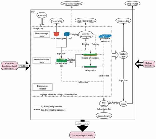
Hydrological models that can assist in sponge city construction have special requirements for simulating and processing. For the final objective of developing an eco-hydrological model, it is essential to establish a strategy of multi-scale simulation of eco-hydrological processes based on refinement consideration ().
Figure 1. Modeling requirements for sponge city construction.
Eco-hydrological model
The direct goal of sponge city construction is to effectively reduce the impact of rainstorms (especially flash floods) on a city by constructing LID facilities and ensuring effective urban storm water management. In contrast to the previous approach of “rapid removal and end concentration,” the approach of “slow discharge and release and dispersed sources” is adopted in sponge city construction, in which a comprehensive application of seepage, retention, storage, drainage, and utilization approaches is adopted (). Moreover, many studies have shown that the changes resulting from urbanization in canopy interception, evapotranspiration (Grimmond and Oke Citation1991; Salvadore, Bronders, and Batelaan Citation2015), infiltration (Zhou et al. Citation2010; Jacobson Citation2011; Wang et al. Citation2011), and depression (Tholin and Keifer Citation1960; Marsalek et al. Citation2007) have substantial impacts on surface runoff and pipe network runoff (Berthier et al. Citation2006; Rodriguez, Andrieu, and Morena Citation2008). Therefore, in addition to drainage and depression-related hydrological processes, it is also necessary to simulate eco-hydrological processes such as canopy interception, evapotranspiration, and infiltration (), which are more closely related to seepage, retention, and storage. All these processes directly affect the design, implementation, and evaluation of the corresponding construction measures.
The long-term goal of sponge city construction is that a city can “adapt flexibly” to environmental changes and natural disasters (Qiu Citation2015). This means that sponge city construction should develop or improve urban ecosystem services and ensure the sustainable management of water resources. Understanding the complexity and long-term nature of the water cycle and coupling the long-term and continuous eco-hydrological processes in urban areas is the scientific basis for achieving this goal ().
In summary, to complete both the direct and long-term goals of sponge city construction, a renewed interdisciplinary approach is required to understand the way urban ecosystems operate and to develop coupled urban eco-hydrological models describing both transient runoff processes and continuous water cycle budgets ().
Multi-scale and landscape-based model
Sponge city construction creates a multi-scale and landscape-based water ecological infrastructure (Qiu, Citation2015; Che et al. Citation2015; He et al. Citation2019). Eco-hydrological processes can shape landscape patterns, which in turn can affect water movement and storage and produce different hydrological responses (Ferguson Citation1992; Gao et al. Citation2018). This pattern-process relationship is scale-dependent (Salvadore, Bronders, and Batelaan Citation2015). An important strategy to reveal pattern-process-scale relationships requires identifying the multi-scale patterns of an urban landscape (for example, from points to locals to sub-catchments or catchments to landscapes), establishing a multi-level hierarchical simulation system of eco-hydrological processes, and ultimately exploring the mutual feedback between these processes and landscape patterns within and among different hierarchical levels ().
Refined simulation
The sponge city construction focuses on the land cover composition and spatial configuration of local areas. Urban areas are characterized by complex and fragmented land covers, small catchment sizes, inconspicuous boundaries of adjacent catchments, and varied micro-topographic changes (Xu and Zhao, Citation2016; Liu et al. Citation2017). All these characteristics make a refined simulation become an essential basis (). This specialized simulation can be considered from two perspectives. The first concerns the refinement of the topography and land cover information. During a rainstorm process, even if both given surfaces are pervious or impervious, their temporal variations in surface runoff may differ considerably (Wan and Yang Citation2007). Thus, simply distinguishing pervious from impervious surfaces is not sufficient, and classifying more refined land cover types is suggested. The second perspective regards the fine division of basic hydrological response units (HRUs). Traditional distributed or semi-distributed hydrological models usually use catchments as basic HRUs; however, these are not sufficient for refined simulation (Arnold and Fohrer Citation2005). In contrast, grid-based units can thoroughly describe the spatial heterogeneity of urban land cover and should meet the requirements for fine division (Rodriguez, Andrieu, and Morena Citation2008; Jacobson Citation2011).
Hydrological models for sponge city construction
Traditional hydrological models
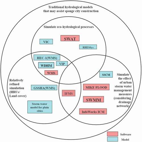
Based on the above requirement analysis, we found multiple hydrological models that may assist sponge city construction from those currently widely used or having local validations. These suitable models can be categorized into storm water management models and eco-hydrological models according to the simulated processes ().
Figure 2. Traditional hydrological models that may assist sponge city construction.
Storm water management models
Storm water management models are mainly used to simulate regional rainfall runoff, and the simulated results can be used as the basis for storm water management ().
Table 1. Storm water management models
The storm water management model (SWMM) is the most extensively studied and widely used urban storm water management model (Tsihrintzis and Hamid Citation2015). It classifies land cover types into pervious and impervious surfaces and simulates the surface runoff within catchments as well as the one-dimensional flow movement in pipe networks (Rossman and Huber Citation2016). SWMM also includes LID and runoff water quality modules. SWMM has been widely used to simulate the water accumulation and drainage effect under different rainstorms and runoff processes under different rainfall characteristics and land covers in China, and its accuracy and reliability have been verified (Liu et al. Citation2006; Cong et al. Citation2006; Zhao et al. Citation2008; Chen, Zhang, and Wu Citation2014; Luo et al. Citation2020). However, SWMM neglects some critical ecological processes (such as canopy interception) that may greatly influence surface runoff during rains, and simplifies (even neglects at many situations) the simulation of evapotranspiration that may greatly influence surface runoff after rains. It uses catchments as the basic simulation units and ignores the spatial heterogeneity of land surface within the catchments that may influence water flows. It considers the impact of change of land cover composition (such as pervious area ratio) on surface runoff, while the impact of land cover configuration is not fully explored.
Both InfoWorks ICM (integrated catchment management) and MIKE FLOOD are comprehensive simulation systems commonly used in urban storm water management. They construct a hydraulic model for urban drainage to simulate the interaction between the drainage network and rivers; based on this simulation, a risk assessment of urban waterlogging disasters and a further assessment of the drainage and storage capacity of drainage networks may be made (Sun et al. Citation2006; Tan Citation2007; Patro et al. Citation2009; Li Citation2014). Like SWMM, these systems also use catchments as the basic HRUs and simply classify the land cover types according to their permeability or storm water management measures (e.g., LID and BMPs (best management practices)).
WMS (watershed modeling system) is a type of watershed-oriented comprehensive simulation system that included the grid-based continuous hydrological model HEC-1 (hydraulic engineering center hydrologic modeling system) and distributed hydrological model GSSHA (gridded surface subsurface hydrologic analysis). It differs in multiple land cover types and simulates surface runoff based on grids. WMS is also widely used in watershed planning and runoff forecasting (Downer and Ogden Citation2004; Cline, Molinas, and Julien Citation2010; Han, Jianming, and Shuigen Citation2014). However, it does not consider pipe flow and storm water management measures (such as LID), which are important for sponge city construction.
In addition to the aforementioned international software programs, China has independently developed a series of hydrological and hydraulic coupling models for storm water management. The storm pipeline simulation calculation model (SSCM) is the first complete model for rainfall-runoff calculation and design in China and is mainly used in urban storm water control and storm water pollution prevention (Cen, Zhan, and Hong Citation1993). SSCM includes modules for rainstorms, surface runoff generation and routing, flow in pipe networks, and drainage network design. A storm water model for plain cities (especially in China) is established, including four modules: runoff generation, overland flow, flow in pipe networks, and river routing. The simulation of runoff generation considers land cover and hydraulic conditions and thus has a relatively higher accuracy (Xu Citation1998). The integrated urban flood modeling system (IFMS), a domestic flood analysis software, was specially developed for urban flood disasters by integrating a 1D drainage network model and a 2D surface hydraulic model (Yu et al. Citation2018). The Wenyuhe River distributed hydrological model (WDHM), a distributed hydrological model considering different land cover types, describes eco-hydrological processes such as vegetation interception, soil infiltration, surface runoff, and river routing (Tang et al. Citation2005). However, it was initially established for the Wenyu River basin in Beijing; thus, WDHM must be calibrated and validated before being applied to other basins (Tang and Peng, 2009). These self-developed models can simulate urban storm runoff, and some may be run on grids. However, all these models do not include storm water management measures and their effects on runoff processes.
Coupled eco-hydrological models
The water cycle is an extremely complex and continuous process. Eco-hydrological models, based on the water cycle and water-energy balance of the “soil-plant-atmosphere continuum” (SPAC) system, can explain and describe this complex process to a certain extent (Philip and Forecasting Citation1969). This is essential information in guiding sponge city construction.
According to the coupled mechanism, eco-hydrological models can be divided into three categories. The first is a hydrological model that is coupled with ecological processes. For example, the variable infiltration capacity (VIC) model compensates for traditional hydrological models in describing the energy fluxes and estimating the momentum exchanges of water, heat, and carbon dioxide in an SPAC system (Rodriguez and Tomasella Citation2015). However, it cannot simulate plant growth processes in detail. In contrast, the soil and water assessment tool (SWAT) can simulate plant growth processes, although it only utilizes a fixed plant growth model (Jia and Wen Citation2005). The second approach includes ecological models that are coupled with hydrological processes. For example, the Regional Hydro-ecological Simulation System (RHESSys) is based on carbon flux and water flux; however, it cannot fully reflect the impact of ecological processes on hydrological processes (Morán-Tejeda et al. Citation2014). The third method is the biphasic coupling model. An example is the vegetation interface processes (VIP) model, which is based on energy balance and the water, carbon, and nitrogen cycles (Mo, Liu, and Lin Citation2012).
Clearly, current eco-hydrological model research is still in the exploratory stage. The main barrier to its development is the inconsistency of the scale between ecological processes and hydrological processes. Generally, reparameterization or lumping approaches are adopted to upscale fine ecological processes, but these are accompanied by losses or unsolicited modifications of information. Moreover, most eco-hydrological models are for natural watersheds that do not fully account for human activities, which is a critical requirement for analyzing urban areas (Lei Citation2011; He and Frank Citation2018).
In summary, the aforementioned traditional models have strengths and weaknesses in sponge city construction. First, most models are run at one scale (such as catchment or grid). The lack of multi-scale simulation makes it impossible to derive the relationships between eco-hydrological processes and landscape patterns across different scales, which is one of the scientific bases for sponge city construction. Next, storm water management models focus on the hydraulic processes of drainage and weaken the flow generation processes, and few consider the interactions between ecological and hydrological processes. Eco-hydrological models do account for these interactions; however, their coupling mechanisms are deficient and upscaling remains difficult. Moreover, these eco-hydrological models are mostly oriented to natural watersheds, which have considerably different characteristics from urban catchments or watersheds. Additionally, catchments or sub-catchments are often used as basic HRUs in both models. In storm water management models, land cover types are mostly simplified into pervious and impervious surfaces. Simulations for these artificially homogenized land surfaces cannot reflect the internal flow connectivity, which is closely associated with the fine composition and configuration of land covers. Finally, given the biophysically based nonlinear eco-hydrological mechanisms and numerical simulations inherent in these models, it is difficult to improve the computational efficiency. Thus, the contradiction between the simulation accuracy and computational efficiency is highly prominent, especially when the study area is broad and the spatial or temporal grain is fine. These shortcomings of the traditional hydrological models have limited their application to sponge city construction.
Hydrological models based on cellular automaton
Cellular automaton (CA) can provide a simulation framework that establishes simple local transition rules and adopts them in each local area so that the complex dynamical evolution process over an entire system can be simulated. These rules may depend on the states of a cell and its neighbors and their local interactions at the previous time step. CA has been introduced to hydrology field to improve the structures and ideas of traditional models, and it may represent a valid alternative to classic biophysically based methods and empirical approaches (Chase Citation1992; Favis-Mortlock Citation1998; Rinaldi et al. Citation2007; Ma, Zhou, and Guo Citation2009). The bottom-up simulation approach of CA provides a useful framework for developing multi-scale and landscape-based models. Based on fine cell units, CA has a discrete data structure in time and space, which makes it efficient in refining simulations. Finally, CA provides a parallel computing approach, which is more efficient than classic differential equation methods for modeling complex hydrological and hydraulic processes (Wolfram Citation1984; Mendicino, Pedace, and Senatore Citation2015).
However, some issues must be concerned when using CA for real landscapes with specific environments and requirements. The selection of flow direction is one of the issues. The simplest single-flow-direction (SFD) algorithms, such as D8 (O’Callaghan and Mark Citation1984) and ρ8 (Fairfield and Leymarie Citation1991), assume that all the flow within a cell is transferred to one downstream adjacent cell. Since SFD only considers the elevation difference and ignores the water volume within the cell, it cannot reflect the flow interaction between cells and cannot capture the dynamic variation in runoff (Shao et al. Citation2015). In contrast, the multiple-flow-direction (MFD) algorithm considers multiple possible downstream adjacent cells and performs more accurately than SFD, especially for small-scale watersheds (Zhan, Qin, and Zhu Citation2012). Notably, whichever algorithm is selected, the definition of the cell neighborhood (such as 4 or 8 neighborhoods) may greatly affect the simulated values, and thus, a comparative study is also needed to determine the most suitable neighborhood in a real landscape (Erskine et al. Citation2006).
Another issue regards the selection of time step. Given that the CA model is usually run at a high spatial resolution, it is especially critical to adapt the time step to simultaneously achieve a high simulation accuracy and high computational efficiency (Mendicino, Pedace, and Senatore Citation2015). As the cell size decreases, the corresponding water surface slope may become larger, so the simulated discharges will be overestimated when not considering the inertial effect of fluxes that may reduce the water fluxes between cells in gradually varying shallow water flows (Guidolin et al. Citation2016). This problem can be alleviated by reducing the time step. However, reducing the time step may cause an exponential reduction in computational efficiency (Hunter et al. Citation2006). For this problem, modifying formulations for the water flux in the CA model may be a solution. For example, Bates et al. (Citation2010) introduced the inertial term in the De Saint Venant equations into a 2D flood inundation model, which maintains the overall accuracy of the results, while reducing the run time by the use of a great and stable time step. Dottori and Todini (Citation2011) implemented the local adaptive time step algorithm within the CA model to make the time step contain locally given values that are significantly smaller than those in the rest of the computational area, which can increase the computational efficiency by 25%–70% without a loss in accuracy compared with global adaptive time step methods.
Most importantly, to process complex phenomena or real landscapes, it is often necessary to expand classic CA models to allow more complicated cell space structures and real transitions rules. CA models used for constructing a sponge city require necessary expansion or integration and the structure of CA makes it susceptible to expansion and integration. There are some examples of these adaptions. First, the classic CA models use uniform cells as basic units. By contrast, in the expanded models, polygonal grids with irregular sizes and shapes that represent actual micro spatial entities (such as land cover patches or geographical units) can be used as basic units. Next, the classic CA rules are mostly characterized by local interactions, from which the entire system is directly scaled up without any intermediate level(s). However, in a real landscape, the states of a cell are also affected by factors or processes at scales broader than the neighborhood. These effects are usually limited within a patch or geographical unit with a homogeneous land cover, landform, or LID practice. Hence, multi-layer neighborhoods and a CA-based multi-scale simulation system is required to exhibit eco-hydrological processes at multiple scales and their gradually upscaling relationships from cells and neighbors to a patch or geographical unit and a subsequent sub-catchment. Moreover, the classic CA assumes that the transition rules are homogeneous for all cells. For a large region, unique rules may be set for different sub-landscapes owing to, for example, unique driving factors, especially landscape patterns and land-use policies closely associated with human activities. Lastly, CA has the property of self-organization, which suggests that it can provide an efficient approach to develop an agent-based CA (Arai and Basuki Citation2012). Cell water moves like an agent growing in biological behavior with interactions among neighboring cell waters and interactions between cell water and the surrounding environment.
Prospects of urban eco-hydrological models
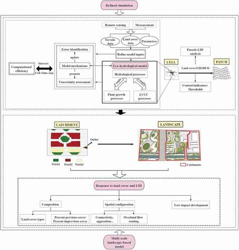
Under the simulation framework that CA models provide, the critical concerns include what processes and what pattern-process relationships are adopted at certain spatial scales for sponge city construction ().
Figure 3. Framework of eco-hydrological model for sponge city construction.
Multi-scale simulation
Considering the multi-scale nature of sponge city construction, it is necessary to construct a multi-scale spatial hierarchical structure from cells or locals to patches (such as different land covers, LIDs, and depressions) to sub-catchments or catchments to landscapes (). Based on this hierarchical structure, a multi-scale eco-hydrological simulation system may be constructed to simulate discrete eco-hydrological processes at different scales and the mutual feedback between the eco-hydrological processes and spatial patterns at corresponding scales. Pattern-process relationships across different scales may also be explored. This simulation system may effectively address scale inconsistency by linking fine-scale ecological processes (such as rainfall interception of tree canopy) with board-scale hydrological processes (such as surface runoff). It is conducive to naturally upscaling eco-hydrological processes when building connections among cells, patches, or sub-catchments. For example, the surface flow among cells exactly reflects the hydrological process at the patch scale; the flow among patches exactly reflects the process at the catchment scale.
However, relevant multi-scale studies are not yet sufficiently thorough. The most common studies are to partition a large watershed into multiple catchments and then further multiple sub-catchments, and simulate the eco-hydrological processes at different hierarchical levels (Shao et al. Citation2019; Li and Zhao, Citation2017). Noh et al. (Citation2019) summarized and captured the runoff process at different scales based on the basic high-resolution simulation results from a high-resolution hydrodynamic model. Sidle et al. (Citation2017) developed a multi-scale nested simulation approach, in which eco-hydrological processes at different scales (such as canopy interception and infiltration at a site and evapotranspiration at a plot) are firstly monitored, and then are simulated at their respective optimal scales, further they are linked by upscaling and downscaling. Although there are just a few examples of multi-scale studies, they provide critical heuristics to the future development of eco-hydrological simulation.
When constructing a grid-based multi-scale simulation system, an appropriate grid size (spatial grain) and time step (temporal grain) must be selected (). If the grid size or the time step is too small, the simulation efficiency is low; if they are too large, the error from the analytical solution of the kinematic wave equation describing flow movement is substantial. Generally, the broader the grid, the more the micro-topography information is masked and the flatter the terrain is, resulting in a reduction in the simulated flow rate, total runoff, and peak discharge (Fread Citation1985; Chow, Maidment, and Mays Citation1988; Hessel Citation2005; Vivoni et al. Citation2005). The larger the time step, the more the instantaneous dynamic information of rainfall is masked and the rainfall intensity is averaged, thereby resulting in a decrease in peak discharge; however, this may have a minimal effect on the total runoff. Studies have shown that there may be a threshold for the effect of the time step on the runoff process. When this threshold is exceeded, both the peak discharge and total discharge decrease, and the simulation error increases accordingly (Hessel Citation2005).
The determination of the optimal spatial scale to simulate the relationship between certain ecological or hydrological processes and spatial patterns is also a key issue. The pattern-process relationship can only be correctly revealed at an appropriate scale (Allen and Starr Citation1982; O’ Neil, Citation1986; Wu Citation2004). Determining the spatial scale(s) with significant correlation after analyzing the relationships between ecological or hydrological processes and spatial patterns at each scale is an effective means. Peng et al. (Citation2020) proposed a single-scale coherence rate index and analyzed the priority scale using a multi-factor attribution analysis for urban land surface temperature. This method is also applicable to eco-hydrological research. Before doing this, the critical characteristic scales (or intrinsic scales) at which the phenomena of spatial patterns or ecological or hydrological processes occur are supposed to be identified first. Multi-scale analysis methods in landscape ecology can provide such an approach, including wavelet analysis and scale variance analysis (Moellering and Tobler Citation1972; Wu Citation2007; Zhang and Zhang Citation2011) for an eco-hydrological process and landscape metric scalograms (Zhang and Li Citation2013) for land cover patches or LID facilities.
Simulation of urban eco-hydrological processes
The key to the urban eco-hydrological model is to address the coupling of hydrological processes and vegetation growth and the impact of land-use/cover change (LUCC) on hydrological processes ().
Hydrological processes are closely related to the ecological processes of vegetation (Mcclain et al. Citation2014; Sela, Svoray, and Assouline Citation2015). However, vegetation is generally regarded as a static influencing factor in a hydrological model, as either empirical parameters are used to generalize the effect or remote sensing products are utilized to exhibit the spatial variation in vegetation density (e.g., normalized difference vegetative index and leaf area index) at certain times. Most temperate vegetation growth and soil properties have obvious seasonal variations and thus produce seasonal effects on eco-hydrological processes, such as the interception of tree canopy and land surface litter, soil water flow, and soil-surface-atmosphere fluxes. Vegetation growth, in turn, responds to dynamic soil water availability, which is the outcome of the hydrological cycle. This suggests a renewed understanding of the mutual relationships between hydrological processes and vegetation dynamics.
LUCC is the most direct embodiment of human activities. Through changing land surface conditions, LUCC has become the most direct human driving factor affecting urban eco-hydrological processes. However, characterizations of the impacts of LUCC are generally based on the assumption that the land surface conditions are fixed within a certain simulation period (Maheepala, Takyi and Perera Citation2001; Li and Ye, Citation2007). This assumption is a compromise regarding the lack of dynamic land cover information. The time interval of the current land cover data is mostly 5 or 10 years, which therefore cannot reflect the LUCC within a certain 5 or 10 years. When using this data, it is nearly impossible to improve the simulation accuracy, especially for local flash floods. The usual solution is to obtain land cover data with a temporal resolution higher than the general 5 or 10 years. However, the optimal resolution is not equal to the high resolution. The optimal temporal resolution depends on the temporal extent of study associated with the study objective (Zhang Citation2006). The inconsistency between temporal resolution and extent can significantly reduce simulation accuracy. For example, in the temperate areas, if the temporal extent covers the entire flooding period (e.g., from June to August) or certain flooding period when most plants are in their growing peak with relatively stable growing dynamics and thus relatively stable absorbing water and transpiration dynamics, land over data for any period during the growing season may meet the requirement for simulation accuracy (Jin and Jin, Citation2018). If the temporal extent goes through one year from spring to winter, land cover data during both the growing and non-growing seasons is needed because land covers (especially deciduous vegetation) have great differences in different seasons (Rudorf, Melack, and Bates Citation2014). If the temporal extent goes across multiple years, land cover data during the growing seasons within each year may be needed to exhibit the possible great interannual variation in vegetation types and growing conditions (Cuo et al. Citation2008). Only if the temporal extent goes across decades, land cover data over the years (e.g., 5 or 10 years) may be used to exhibit the possible great variation in land covers from urban planning or vegetation succession (Omer et al. Citation2017). The long-term sponge city construction inevitably accompanies with continuous urban development. To formulate construction schemes that can coincide with future urban development, it is usually necessary to couple LUCC prediction models with hydrological models.
Eco-hydrological responses to composition and spatial configuration change of urban land cover
Composition of land cover refers to various land cover types and the areal proportion of each type. Spatial configuration of land cover refers to the spatial distribution characteristics of patches composed of adjacent units with the same land cover type. Land cover composition and spatial configuration determine the storage, exchange, and movement of water flow (Baldwin et al. Citation2004; Kearns et al. Citation2005; Shi, Lei, and Li et al. Citation2013). Some ecologists and landscape planners believe that land cover composition has a significant impact on surface runoff processes (DeFries and Eshleman Citation2004; Glavan, Pintar, and Volk Citation2013), whereas others believe that land cover configuration is more important for improving the hydrological service function of a catchment (Ziegler et al. Citation2007; Shi et al. Citation2013). Given the lack of quantification of how and to what extent the land cover composition and configuration affect eco-hydrological processes, this information cannot be used to provide scientific advice and formulate effective evaluations of sponge city construction and management (Zhou, Wu, and Peng Citation2012; Wang, Liu, and Zhao Citation2014; Su et al. Citation2014; Elledge and Thornton Citation2017).
Eco-hydrological responses to composition change of land cover
Urban eco-hydrological processes are highly sensitive to changes in the permeability of land surfaces, regardless of rainfall characteristics (Endreny and Thomas Citation2009). In many models, urban land surfaces are often classified as pervious and impervious types, and the eco-hydrological responses of land covers with different permeabilities are estimated (Kang, Park, and Singh Citation1998; Tucci Citation2001; Tao and Jiang, Citation2019). However, this division usually cannot be used to distinguish the eco-hydrological processes for different land covers, and thus, the results cannot be accurately applied to construction practices. Some models classify land cover types as green spaces, construction land, roads, and water bodies (Zhu Citation2007; Feng, Fu, and Li Citation2015); however, this is far from sufficient. For example, woodlands, grasslands, and shrubs have substantial differences in many eco-hydrological processes such as canopy interception, root water absorption, transpiration, and evaporation; common asphalt roads and brick roads have highly different infiltration capacities and flow resistances (Axel, Daniel, and Gerd Citation2002). The different eco-hydrological responses caused by different land covers are a particularly critical basis for sponge city construction ().
Previous studies have been mostly concerned with the impact of urbanization (i.e., the transition from less to more impervious covers) on eco-hydrological processes; they have focused mostly on impervious covers and their hydrological responses, with much less attention paid to pervious covers and their responses (Law, Cappiella, and Novotney Citation2009). In contrast, sponge city construction concentrates on ecological restoration (i.e., the transition from less to more pervious covers). The minimum percent pervious cover (PPC) that should be retained or restored to effectively alleviate urban storm floods must be quantitatively determined (). The minimum PPC is a critical threshold that varies with rainfall levels and landscape patterns; thus, it must be determined separately under different conditions. When the PPC is lower than this threshold, the increase in pervious area has a significant impact on hydrological processes such as surface runoff, while when PPC is higher than this threshold, the hydrological response of pervious area change is not as obvious. Zhang et al. (Citation2018) conducted a study in a high-density urban area surrounding the North Moat in Beijing, China, and found that 30%–40% may have been the critical threshold for PPC to affect the surface runoff of some sub-catchments. When PPC was less than 30%–40%, surface runoff decreased more rapidly with an increase in PPC. Given that PPC reaching a minimum threshold may be one of the most efficient measures to control storm flooding in highly urbanized and constrained areas, this metric deserves considerable attention in a model.
Eco-hydrological responses to spatial configuration change of land cover
Except for PPC or percent impervious cover (PIC) and their thresholds, the spatial configurations of different land cover patches also have an important impact on the eco-hydrological processes in urban areas (). When reflecting the relationship between urbanization and hydrological changes, certain non-spatial indicators are usually used to quantify urbanization, such as population density, road density, urban land-use area, and green space area (Jacobson Citation2011). In the past decade, some studies have addressed the spatial configuration of pervious or impervious patches, among which landscape metrics are often used. Except for area-related metrics such as the mean patch size of impervious patches and the largest patch index of green patches (Alberti et al. Citation2007; Zhang et al. Citation2015, Citation2018), the metrics associated with connectivity, fragmentation, aggregation or dispersion of pervious or impervious patches are also often used (Hattermann et al. Citation2004; Mejia and Moglen Citation2009, Mejia and Moglen Citation2010 LinkManagerBM_REF_1ejhVsKT; Luo, Zhang, and Yan Citation2011; Zhang et al. Citation2015, Citation2018). Some studies have shown that these metrics can significantly affect the urban eco-hydrological processes. Increasing the area of pervious patches in a catchment as well as their aggregation, connectivity, or proximity, or reducing their dispersion, can significantly weaken surface runoff. Conversely, performing these actions to impervious patches can significantly enhance rain (especially rainstorm) runoff. However, all these findings have resulted from the correlation analysis between the modeled processes and metrics estimated separately; the future research should determine how to involve landscape metrics and their effects in an eco-hydrological model ().
In addition to landscape metrics, some spatial statistical methods can also be used to identify other spatial configuration characteristics of patches. For example, lacunarity analysis and fractal analysis can be used to identify the spatial distribution of different patch types, such as randomness, clustering, regularity, or fractal structures; join count analysis can be used to analyze the positive or negative spatial association of a certain patch type. Although there are explicit spatial configuration indicators, their effects on urban eco-hydrological processes are still implicit. In addition, similar to landscape metrics, including these indicators and their effects in an eco-hydrological model is also a challenge.
Shuster et al. (Citation2005) and Roy and Shuster (Citation2010) defined effective impervious areas (EIAs) as the area of impervious cover that is hydraulically (directly) connected to the drainage system. A large EIA can drastically increase runoff volume, flow rate, peak flow, and flood frequency. Spatial organizations of overland flow routings may differ between pervious or impervious surfaces and outlets (). For example, Zhang et al. (Citation2018) defined four flow routings based on those in the SWMM. For the direct flows from a pervious surface to an outlet (PERV) or the flows from an impervious surface over a pervious surface to an outlet (IMPERV-PERV), the flow connectivity is low, whereas for the direct flows from an impervious surface to an outlet (IMPERV) or the flows from a pervious surface over an impervious surface to an outlet (PERV-IMPERV), the flow connectivity is high. Studies have shown that when the PPC is small, the runoff of most rainfall (except for extraordinary rainstorms) can be substantially reduced if the overland flow routing changes from IMPERV or PERV-IMPERV to IMPERV-PERV. This means that it is feasible to ensure that a catchment can stringently control floods by changing overland flow routings, even if the pervious area is small. As it is affected by the spatial heterogeneity of micro-topography and land cover, the overland flow routing within a catchment may be complex and varied. A key issue is how to extract these flow routings’ commonness and distinguish their differences to ensure appropriate classifications in the modeling process. The classification depends on the permutation and combination of types of micro-topography and land cover and their spatial arrangements. There might be quite a few flow routings based on the number of pervious and impervious patches and their arrangements on a continuously declining slope, let alone on a rugged slope. In addition, the discretization of sub-catchments as limited by terrain and land cover type data will also affect the determination of flow routings and the estimations of their effects on hydrological processes.
Eco-hydrological responses to low impact development practice
LID practice is the most practical measure for sponge city construction. According to different regulation purposes, there are different LID types, including water storage measures (e.g., rain barrels, green roofs and pervious pavements) and water collection measures (e.g., rain gardens, sunken green spaces, and bio-retention cells) (). Appropriate LIDs can only be selected under different construction conditions after the runoff reduction effects of different LID types and their spatial arrangements are quantified.
The method of scenario simulation is often used to analyze the runoff reduction effects of different LID types, a single LID type using different materials, and combinations of different LIDs (Hakimdavar et al. Citation2014; Hu, Ren, and Pei Citation2015; Huang, Wang, and Zhang Citation2017; Peng et al. Citation2018). However, relevant analyses are still limited. We therefore must quantify the runoff reduction effects of different LIDs (including individuals and combinations) in all scenarios, systematically summarize the control indicators and thresholds that may affect eco-hydrological processes (), and build a complete technology and theoretical system for the corresponding modeling (Sun Citation2011).
Some models (e.g., SWMM) have addressed the runoff reduction effects of different LID types and the impact of rainfall characteristics (such as rainfall, rainfall duration, and rainfall peak) on LID practices, whereas less attention has been provided to the spatial arrangement of LIDs (Qin, Li, and Fu Citation2013; Li et al. Citation2018). The area of a single LID is limited (0–40 hm2), and thus multiple single or combined LIDs are often utilized (Shen, Zhang and Xu Citation2018). This requires setting scenarios with different spatial arrangements to analyze the runoff reduction effects of the spatial locations and spatial distribution of multiple single LIDs and the spatial organization and flow routing of combined LIDs. However, the related research and models on this subject are deficient.
Different land cover types may have unique eco-hydrological processes, and thus the LIDs that can be applied to certain land covers may differ (Tang, Li, and Qin Citation2010; Wang, Liu, and Zhao Citation2014). The crux is to correlate LIDs with land cover in the early stage of planning and construction with the aid of models. An effective approach is to decompose the urban area into land parcels according to land-use characteristics (e.g., construction land, roads, and green spaces) or functional characteristics (e.g., residential areas, commercial areas, roads, and squares), and then select suitable LIDs based on these parcels through scenario simulation. For example, LID types (such as sunken green spaces, bio-retention cells, and pervious pavements) may surround the construction land and road to ensure local absorption of rainwater and effective reduction of runoff from the impervious surface. LID types (such as infiltration trenches, vegetative swales, and rain gardens) may also be considered in a green space to more effectively ensure the detention, storage, and infiltration of rainwater (Hu, Ren, and PeiGuozhong Citation2015; Shen, Zhang, and Xu Citation2018). For complex land parcels with multiple land covers (such as residential areas), the runoff processes of typical catchments with different land cover combinations may be compared, as the LID type that is planned will depend on both the functional characteristics and land cover composition in these combinations (Li Citation2020). Therefore, an important model development is to add the corresponding parcels-LID analysis module to provide decision-makers with an overall viewpoint of infrastructure construction ().
Accurate simulation
Three improvements are suggested to improve simulation accuracy: refine model inputs, evaluate modeling performance, and improve the computational efficiency of the model ().
First, refining inputs, such as rainfall, terrain, land cover, and catchment data, is a necessary condition for accurate simulations (). It is also critical to match the resolution of the input data with the simulation spatiotemporal scale, although it is easily ignored (Xu Citation2010). However, data in urban areas are relatively scarce, and it is difficult to obtain input data with a high precision and corresponding resolution. Remote sensing technology, especially high-resolution remote sensing, hyperspectral remote sensing, and lidar technology, as well as certain algorithms can provide highly detailed land cover and morphology information that might meet certain data requirements (Wu and Liu, Citation2002).
Second, the aim of model development is to achieve accurate and reliable modeled values. Accurate and reliable results are not equal to deterministic results; in contrast, most are uncertain with a probability distribution. It is very important to perform an uncertainty analysis of the modeled values. However, related research is still lacking in the hydrological field (Pappenberger and Beven Citation2006). The input data from different sources, such as field measurements, remote sensing inversions, and simulations will inevitably have errors and uncertainties (Coon and Reddy Citation2008). Identifying and evaluating error sources and formulating uncertainty assessments of input data are important aspects of uncertainty analyses ().
Except for the input data, the rationality of the assumptions and the authenticity of the simulated processes have the greatest impact on the credibility of the results (). The assumptions of a model can simplify the presentation of a complex urban system and its internal processes, but the premise is the suitability of the assumptions. On the other hand, to ensure that the simulated processes are increasingly realistic, certain assumptions may be replaced with real cases, although this will obviously increase the complexity and reduce the universality of a model. In other words, the authenticity and universality of a model can be adjusted by changing the assumptions. However, related uncertainty analyses are still rare in studies on hydrological or eco-hydrological models (Park Citation2012).
Understanding the biophysical mechanisms of the SPAC system in an urban environment is the basis for determining the authenticity of the simulated processes (). However, limited understanding limits the development of urban eco-hydrological models (Xu Citation2010). It is indispensable to constantly integrate the latest mechanistic findings for future model development.
Finally, the computational efficiency is greatly reduced when refining the input data and complicating the simulated processes to increase simulation accuracy (). Generally, the computational efficiency can be improved by simplifying the calculation processes, such as through enlarging the computational grids (Yu and Lane, Citation2006; Liu et al. Citation2013), replacing the Saint-Venant equation with the motion wave or diffusion wave equations (Zou et al. Citation2015; Li, Citation1998), and estimating the flooded area while ignoring the flow simulation (Li and Ye Citation2007; Chen, Hill, and Urbano Citation2009; Krupka Citation2009; Zhang, Wang, and Zhao Citation2014). Nevertheless, these approaches usually reduce the simulation reliability and may cause partial losses of valid information. Developing models based on the CA framework and parallel computing technology represent an effective approach.
Conclusions
Developing urban eco-hydrological models is an indispensable method to understand complex urban eco-hydrological processes. Understanding these processes may provide an essential scientific basis for ensuring the sustainable development of urban water resources through sponge city construction. To develop an urban eco-hydrological model and apply it to sponge city planning, construction, and management, four crucial issues that must be addressed are summed as follows. The first is the scale issue, including conducting a multi-scale simulation system, identifying the most suitable simulation grain, and determining the spatial scale with a significant correlation between ecological or hydrological processes and spatial patterns. The second is the coupling of ecological processes (especially vegetation growth dynamics and LUCC) and hydrological processes. The third is the relationship between eco-hydrological processes and composition and spatial configuration of land covers. For land cover composition, we suggest subdividing the land cover according to permeability and underlying characteristics and utilizing PPC and its eco-hydrological effects in the model. We also suggest developing additional methods to quantify various spatial configurations of patches, involving spatial configuration indicators and their effects in an eco-hydrological model, distinguishing spatial organization of overland flow routings, and further exploring the combined effects of overland flow routings and PPC on eco-hydrological processes. Furthermore, we suggest systematically simulating the effects of different LIDs, exploring the effects stemming from different spatial arrangements of multiple single LIDs or combined LIDs, and adding the parcels-LID module to correlate the LIDs with their surrounding or internal land-use types or functional areas. The fourth is ensuring an accurate simulation; this is related to refining the input data, addressing the uncertainty of the input data, detailing the assumptions used for simulated processes, updating our understanding of water cycle mechanisms, and improving the computational efficiency.
The improved models should estimate hydrological processes, predict peak discharges of rainstorms, and control flood hazards and thereby assist in sponge city construction. Moreover, they also provide warnings needed to ensure the long-term sustainable management of urban water resources under future climate and land-use changes.
Acknowledgments
This work was supported by the Natural Science Foundation of Beijing Municipality under Grant 8181001; Special Fund for Scientific Research Cooperation between Colleges and Institutes of University of Chinese Academy of Sciences under Grant Y65201NY00.
Finally, we would like to thank Editage (http://www.editage.cn/index.html) for English language editing.
Disclosure statement
No potential conflict of interest was reported by the author(s).
Additional information
Funding
References
- Ahiablame, L., and Shakya, R. 2016. “Modeling Flood Reduction Effects of Low Impact Development at a Watershed Scale.” Journal of Environmental Management 171 (Apr.15): 81–18. doi:https://doi.org/10.1016/j.jenvman.2016.01.036.
- Alberti, M., Booth, D., Hill, K. Coburn, B., et al. 2007. “The Impact of Urban Patterns on Aquatic Ecosystems: An Empirical Analysis in Puget Lowland Sub-basins.” Landscape and Urban Planning 80 (4): 345–361. doi:https://doi.org/10.1016/j.landurbplan.2006.08.001.
- Allen, T. F. H., and Starr, T. B. 1982. Hierarchy: Perspectives for Ecological Complexity. Chicago: University of Chicago Press.
- Arai, K., and Basuki, A. 2012. “Hot Mudflow Disaster that Occurred in Sidoarjo Area, Indonesia and Prediction Model and Simulation Based on Cellular Automata.” Journal of the Japan Society of Photogrammetry and Remote Sensing 49 (3): 149–158. doi:https://doi.org/10.4287/jsprs.49.149.
- Arnold, J. G., and Fohrer, N. 2005. “SWAT2000: Current Capabilities and Research Opportunities in Applied Watershed Modelling.” Hydrological Processes 19 (3): 563–572. doi:https://doi.org/10.1002/hyp.5611.
- Axel, B., Daniel, N., and Gerd, B. 2002. “Effects of Climate and Land‐use Change on Storm Runoff Generation: Present Knowledge and Modelling Capabilities.” Hydrological Processes 16 (2): 509–529. doi:https://doi.org/10.1002/hyp.326.
- Baldwin, D. J. B., Weaver, K., Schnekenburger, F. and Perera, H.A. 2004. “Sensitivity of Landscape Pattern Indices to Input Data Characteristics on Real Landscapes: Implications for Their Use in Natural Disturbance Emulation.” Landscape Ecology 19 (3): 255–271. doi:https://doi.org/10.1023/B:LAND.0000030442.96122.ef.
- Qiu, B.-X. 2015. “Connotation, Approach and Prospect of Sponge City (LID).” Geomatics World, 3: 1–7. (in Chinese). doi:https://doi.org/10.13789/j.cnki.wwe1964.2015.0069.
- Bates, P. D., Horritt, M. S., and Fewtrell, T. J. 2010. “A Simple Inertial Formulation of the Shallow Water Equations for Efficient Two-dimensional Flood Inundation Modelling.” Journal of Hydrology 387 (1–2): 33–45. doi:https://doi.org/10.1016/j.jhydrol.2010.03.027.
- Berthier, E., Dupont, S., Mestayer, P. G. and Andrieu, H. 2006. “Comparison of Two Evapotranspiration Schemes on a Sub-urban Site.” Journal of Hydrology 328 (3–4): 635–646. doi:https://doi.org/10.1016/j.jhydrol.2006.01.007.
- Cai, L.-H. 2016. “Introduction of Hydrological and Hydraulic Models for Sponge City.” Landscape Architecture, (2): 33–43. (in Chinese). doi:https://doi.org/10.14085/j.fjyl.2016.02.0033.11.
- Cen, G.-P., Zhan, D.-J., and Hong, J.-N. 1993. “Calculation Model of Urban Rainwater Pipeline.” China Water and Wastewater, (1): 37–40. (in Chinese). doi:https://doi.org/10.19853/j.zgjsps.1000-4602.1993.01.011.
- Chase, C. G. 1992. “Fluvial Landsculpting and the Fractal Dimension of Topography.” Geomorphology 12 (5): 39–57. doi:https://doi.org/10.1016/0169-555X(92)90057-U.
- Che, S.-Q., Xie, C.-K., Chen, D., Yu, B.-Q. 2015. “Development and Constructive Approaches for Theories and Technologies of Sponge City System.” Chinese Landscape Architecture (in Chinese) 031(6):11–15. doi:https://doi.org/10.3969/j.1000-6664.2015.06.003.
- Chen, J., Hill, A. A., and Urbano, L. D. 2009. “A GIS- Based Model for Urban Flood Inundation.” Journal of Hydrology 373 (1): 184–192. doi:https://doi.org/10.1016/j.jhydrol.2009.04.021.
- Chen, X.-Y., Zhang, N., and Wu, F.-F. 2014. “Impacts of Rainfall and Land Use on Urban Surface Runoff: A Case Study of Area Surrounding the North Moat in Beijing, China.” Journal of Natural Resources (in Chinese) 29 (8): 1391–1402. doi:https://doi.org/10.11849/zrzyxb.2014.08.011.
- Chidammodzi, C. L., and Muhandiki V. S. 2017. “Water Resources Management and Integrated Water Resources Management Implementation in Malawi: Status and Implications for Lake Basin Management.” Lakes and Reservoirs: Research and Management 22 (2): 101–114. doi:https://doi.org/10.1111/lre.12170.
- Chow, V. T., Maidment, D. R., and Mays, L. W. 1988. Applied Hydrology. New York: McGraw-Hill.
- Cline, T. J., Molinas A., and Julien, P. Y. 2010. “An Auto-cad-based Watershed Information System for the Hydrologic Model HEC-1.” Journal of the American Water Resources Association 25 (3): 641–652. doi:https://doi.org/10.1111/j.1752-1688.1989.tb03102.x.
- Cong, X.-Y., Ni, G.-H., Hui, S.-B., Tian, F.-Q., et al. 2006. “Simulation of Storm Waterlogging Value of Urban Interchange Bridges.” Urban Roads Bridges and Flood Control (2): 52–55+152. (in Chinese). doi:https://doi.org/10.16799/j.cnki.csdqyfh.2006.02.018.
- Coon, W. F., and Reddy, J. E. 2008. “Hydrologic and Water-quality Characterization and Modeling of the Onondaga Lake Basin, Onondaga County, New York.” USGS Scientific Investigations Report, 2008-5013 1–85. doi:https://doi.org/10.3133/sir20085013.
- DeFries, R., and Eshleman, K. N. 2004. “Land-use Change and Hydrologic Processes: A Major Focus for the Future.” Hydrological Processes 18 (11): 2183–2186. doi:https://doi.org/10.1002/hyp.5584.
- Deng, S.-H, Zhang, X.-Y., Shao, Z.-Y, Yan, W.-T., et al. 2018. “An Integrated Urban Stormwater Model System Supporting the Whole Life Cycle of Sponge City Construction Programs in China.” Journal of Water and Climate Change 10 (5): 1–15. doi:https://doi.org/10.2166/wcc.2018.197.
- Zhao, D.-Q., Chen, J.-N., Tong, Q.-Y., Wang, H.-Z., et al. 2008. “Study on the Influence of Sub Catchment Division on SWMM Simulation Results.” Environmental Protection (8): 56–59. (in Chinese). doi:https://doi.org/10.3969/j.0253-9705.2008.08.019.
- Dottori, F., and Todini, E. 2011. “Developments of a Flood Inundation Model Based on the Cellular Automata Approach: Testing Different Methods to Improve Model Performance.” Physics and Chemistry of the Earth 36 (7–8): 266–280. doi:https://doi.org/10.1016/j.pce.2011.02.004.
- Downer, C. W., and Ogden, F. L. 2004. “GSSHA: Model to Simulate Diverse Stream Flow Producing Processes.” Journal of Hydrologic Engineering 9 (3): 161–174. doi:https://doi.org/10.1061/(ASCE)1084-0699(2004)9:3(161.
- Elledge, A., and Thornton, C. 2017. “Effect Of Changing Land Use From Virgin Brigalow (Acacia harpophylla) woodland to a crop or pasture system on sediment, nitrogen and phosphorus in runoff over 25 years in subtropical Australia.” Agriculture, Ecosystems & Environment 239: 119–131. doi:https://doi.org/10.1016/j.agee.2016.12.031.
- Endreny, T. A., and Thomas, K. E. 2009. “Improving Estimates of Simulated Runoff Quality and Quantity Using Road-enhanced Land Cover Data.” Journal of Hydrologic Engineering 14 (4): 346–351. doi:https://doi.org/10.1061/(ASCE)1084-0699(2009)14:4(346).
- Erskine, R. H., Green, T. R., Ramirez, J. A., and MacDonald, L. H. 2006. “Comparison of Grid-based Algorithms for Computing Upslope Contributing Area.” Water Resources Research 42 (9): 2006. doi:https://doi.org/10.1029/2005WR004648.
- Fairfield, J., and Leymarie, P. 1991. “Drainage Network from Grid Digital Elevation Models.” Water Resources Research 27 (5): 709–717. doi:https://doi.org/10.1029/90WR02658.
- Favis-Mortlock, D. 1998. “A Self-organizing Dynamic Systems Approach to the Simulation of Rill Initiation and Development on Hillslopes.” Computerand and Geosciences 24 (4): 353–372. doi:https://doi.org/10.1016/S0098-3004(97)00116-7.
- Feng, P., Fu, J., and Li, J.-Z. 2015. “Modelling Analysis of Effects of Underlying Surface Change on Flood Response.” Journal of Tianjin University (Science and Technology) 48 (3): 189–195. (in Chinese). doihttps://doi.org/10.11784/tdxbz201407034.
- Ferguson, B. K. 1992. “Landscape Hydrology, a Component of Landscape Ecology.” Journal of Environmental Systems 21 (3): 193–205. doi:https://doi.org/10.2190/8HLE-91G9-LP0R-XHYG.
- Fletcher, T. D., Andrieu H., and Hamel P. 2013. “Understanding, Management and Modelling of Urban Hydrology and Its Consequences for Receiving Waters: A State of the Art.” Advances in Water Resources 51 (JAN): 261–279. doi:https://doi.org/10.1016/j.advwatres.2012.09.001.
- Fread, D. L. 1985. Hydrological Forecasting. Germany: Wiley.
- Gao, H., Sabo, J.-L., Chen, X., Liu, Z., et al. 2018. “Landscape Heterogeneity and Hydrological Processes: A Review of Landscape-based Hydrological Models.” Landscape Ecology 33 (9): 1461–1480. doi:https://doi.org/10.1007/s10980-018-0690-4.
- Glavan, M., Pintar, M., and Volk, M. 2013. “Land Use Change in a 200-year Period and Its Effect on Blue and Green Water Flow in Two Slovenian Mediterranean Catchments-lessons for the Future.” Hydrological Processes 27 (26): 3964–3980. doi:https://doi.org/10.1002/hyp.9540.
- Grimmond, C. S. B., and Oke, T. R. 1991. “An Evapotranspiration-interception Model for Urban Areas.” Water Resources Research 27 (7): 1739–1755. doi:https://doi.org/10.1029/91WR00557.
- Guidolin, M., Chen, A. S., Ghimire, B., Keedwell, E. C., E. C., Keedwell, et al. 2016. “A Weighted Cellular Automata 2D Inundation Model for Rapid Flood Analysis.” Environmental Modelling and Software 84:378–394. doi:https://doi.org/10.1016/j.envsoft.2016.07.008.
- Hakimdavar, R., Culligan, P. J., Finazzi, M., Barontini, S., et al. 2014. “Scale Dynamics of Extensive Green Roofs: Quantifying the Effect of Drainage Area and Rainfall Characteristics on Observed and Modeled Green Roof Hydrologic Performance.” Ecological Engineering 73 (2014): 494–508. doi:https://doi.org/10.1016/j.ecoleng.2014.09.080.
- Han, S.-W, Zhao, J.-M., Ye, S.-G., and University, C. A. 2014. “Simulation of Rainfall and Runoff in Upstream of Dashihe Basin Based on WMS.” Water Saving Irrigation, : 49–52+57. (in Chinese). doi:https://doi.org/10.3969/j.1007-4929.2014.11.013.
- Hattermann, F., Krysanova, V., Wechsung, F., and Wattenbach, M. 2004. “Integrating Groundwater Dynamics in Regional Hydrological Modelling.” Environmental Modelling and Software 19 (11): 1039–1051. doi:https://doi.org/10.1016/j.envsoft.2003.11.007.
- He, B.-J., Zhu, J., Zhao, D.-X., Gou, J.-D., et al. 2019. “Co-benefits Approach: Opportunities for Implementing Sponge City and Urban Heat Island Mitigation.” Land Use Policy 86:147–157. doi:https://doi.org/10.1016/j.landusepol.2019.05.003.
- He, C.-S., and Frank, W. 2018. “Water Sustainability and Watershed Ecosystem Health.” Ecosystem Health and Sustainability 4 (10): 241–242. doi:https://doi.org/10.1080/20964129.2018.1538666.
- Hessel, R. 2005. “Effects of Grid Cell Size and Time Step Length on Simulation Results of the Limburg Soil Erosion Model (LISEM).” Hydrological Processes 19 (15): 3037–3049. doi:https://doi.org/10.1002/hyp.5815.
- Shen, H.-B, Zhang, S.-H., and Xu, Z.-X. 2018. “LID Facility Allocation and Rainfall-runoff Monitoring for the Future Science & Technology Park in Beijing.” Journal of Hydraulic Engineering 49 (8): 937–944. (in Chinese). doihttps://doi.org/10.13243/j.cnki.slxb.20180269.
- Hu, A.-B., Ren, X.-X., and Pei, G.-Z. 2015. “Simulation of Storm Water Control Effect of LID Municipal Road Based on SWMM.” China Water and Wastewater 31 (23): 151–154. (in Chinese). doihttps://doi.org/10.19853/j.zgjsps.1000-4602.2015.23.033.
- Huang, T.-L., Wang, Y.-P., and Zhang, J.-L. 2017. “Simulation and Evaluation of Low Impact Development of Urban Residential District Based on SWMM and GIS.” Iop Conference 74 (1): 012009. doi:https://doi.org/10.1088/1755-1315/74/1/012009.
- Hunter, N. M., Bates, P. D., Horritt, M. S., and Wilso, M. D. 2006. “Improved Simulation of Flood Flows Using Storage Cell Models.” Water Management 159 (WM1): 9–18. doi:https://doi.org/10.1680/wama.2006.159.1.9.
- Jacobson, C. R. 2011. “Identification and Quantification of the Hydrological Impacts of Imperviousness in Urban Catchments: Areview.” Journal of Environmental Management 92 (6): 1438–1448. doi:https://doi.org/10.1016/j.jenvman.2011.01.018.
- Jin, X., and Jin, Y.-X. 2018. “Impacts of Land Use Data Temporal Resolution on Hydrological Modeling.” Yellow River 40 (9): 5–15. (in Chinese). doihttps://doi.org/10.3969/j.1000-1379.2018.09.002.
- Kang, I. S., Park, J. I., and Singh, V. P. 1998. “Effect of Urbanization on Runoff Characteristics of the On-Cheon Stream Watershed in Pusan, Korea.” Hydrological Processes 12 (2): 351–363. doi:https://doi.org/10.1002/(SICI)1099-1085(199802)12:2<351::AID-HYP569>3.0.CO;2-O.
- Kearns, F. R., Kelly, N. M., Carter, J. L., and Resh, V. H. 2005. “A Method for the Use of Landscape Metrics in Freshwater Research and Management.” Landscape Ecology 20 (1): 113–125. doi:https://doi.org/10.1007/s10980-004-2261-0.
- Krupka, M. 2009. A Rapid Inundation Flood Cell Model for Flood Risk Analysis. Edinburgh, UK: Heriot-Watt University.
- Cuo, L., Lettenmaier, D. P., Mattheussen, B. V., Storck, P., et al. 2008. “Hydrologic Prediction for Urban Watersheds with the Distributed Hydrology–Soil–Vegetation Model.” Hydrological Processes 22 (21): 4205–4213. doi:https://doi.org/10.1002/hyp.7023.
- Law, N. L., Cappiella, K., and Novotney, M. E. 2009. “The Need for Improved Pervious Land Cover Characterization in Urban Watersheds.” Journal of Hydrologic Engineering 14 (4): 305–308. doi:https://doi.org/10.1061/(ASCE)1084-0699(2009)14:4(305.
- Lei, H. 2011. Ecohydrological Processes in a Large Irrigated Area of the North China Plain: Field Observation and Modeling. Beijing: Tsinghua University. (in Chinese).
- Li, B. 2020. Study on Runoff Reduction and Control Effect of Different LID Construction Schemes under Different Rainfall Conditions. Hebei: Hebei University of Engineering. (in Chinese).
- Li, F.-Z., Chen, J.-Q., Engel, B. A., Liu, Y.-Z., et al. 2020. “Assessing the Effectiveness and Cost Efficiency of Green Infrastructure Practices on Surface Runoff Reduction at an Urban Watershed in China.” Water 13 (1): 24. doi:https://doi.org/10.3390/w13010024.
- Li, J. 2014. “Application of Infoworks ICM in Analysis of Urban Drainage System.” China Water and Wastewater 30 (8): 21–24. (in Chinese). doihttps://doi.org/10.19853/j.zgjsps.1000-4602.2014.08.006.
- Li, J., Wu, S., Zhao, X., Yin, W.-C., et al. 2018. “Analysis on the Effect of Rain Type Selection on LID Measures.” Geomatics World 445:21–27. (in Chinese) doi:https://doi.org/10.13789/j.cnki.wwe1964.2018.0097.
- Li, L. 1998. “Inverse Operation of Time-Space and Real -time Flood Forecasting for Dispersive Wave.” Hydrology (6): 1–5. (in Chinese). doi:https://doi.org/10.19797/j.cnki.1000-0852.1998.06.001.
- Li, Y.-Y., and Zhao, W.-M. 2017. “On the Space Planning of Urban Flood Control on a Multi-scale Basis in the Southwest Mountain Cities of China——based on Hydrological Perspective.” Mountain Research 035 (2): 212–220. (in Chinese). doihttps://doi.org/10.16089/j.cnki.1008-2786.000214.
- Li, Z.-H., and Ye, Z.-W. 2007. “Study on Flood Spreading Model of Hongze Lake Based on Cellular Automata”. Journal of Computer Applications (3):718–720. (in Chinese).
- Tang L.-H., Zhang, S.-C., Gao, Z.-Y., Guo, J.-Y., et al. 2005. “Principles and Establishment of WDHM Model in the Upper Basin of Wenyuhe River.” Beijing Water 2:21–23. (in Chinese) doi:https://doi.org/10.3969/j.1673-4637.2005.02.009.
- Liu, J.-H., Mei, C., Xiang, C.-Y., Shao, W.-W., et al. 2017. “Principles of Urban Hydrological Model.” Water Resources and Hydropower Engineering 48 (3): 1–5+13. (in Chinese).
- Liu, J., Guo, L.-H., Zhang, J.-T., and Lv, T. 2006. “Study on Simulation of Drainage and Flooding in Urban Areas of Shanghai Based on Improved SWMM.” China Water and Wastewater 22(21):64–66. (in Chinese) doi:https://doi.org/10.3321/j.1000-4602.2006.21.017.
- Liu, J.-Z., Zhu, A.-X., Liu, Y.-B., Qin, C.-Z., et al. 2013. “Parallelization of a Grid-to-grid Routing Algorithm Based on Grids Layering.” Journal of National University of Defense Technology 351:123–129. (in Chinese) doi:https://doi.org/10.3969/j.1001-2486.2013.01.022.
- Luo, X.-X., Zhang, R., and Yan, D.-H. 2011. “Eco-hydrological Simulation and Regulation of Shuangtaizi Estuarine Wetland.” Journal of Geographical Research 6 (30): 1089–1100. (in Chinese). doihttps://doi.org/10.11821/yj2011060012.
- Luo, Y.-J., Zhang, N.,Li, Q., Wang, X., et al. 2020. “Spatial Analysis of the Effects of Urban Underlying Surface and Rainfall Events on Surface Runoff Based on SWMM: A Case Study of Yanqi Lake Campus of University of Chinese Academy of Sciences.” Journal of University of Chinese Academy of Sciences 371:27–38. (in Chinese). doi:https://doi.org/10.7523/j.2095-6134.2020.01.005.
- Lv, Z.-S., and Zhao, P.-P. “170 Cities are Not Fortified, 340 Cities are Not up to Standard, the First Report on Urban Waterlogging in China: The Risk Is Increasing.” South Weekend, 2013-07-18. http://www.infzm.com/content/92491 (in Chinese)
- Ma, T., Zhou, C.-H., and Guo, Q. 2009. “Modeling of Hillslope Runoff and Soil Erosion at Rainfall Events Using Cellular Automata Approach.” Pedosphere 6 (19): 711–718. doi:https://doi.org/10.1016/S1002-0160(09)60166-1.
- Maheepala, U. K., Takyi, A. K., and Perera, B. J. C. 2001. “Hydrological Data Monitoring for Urban Storm Water Drainage Systems.” Journal of Hydrology 245 (1–4): 32–47. doi:https://doi.org/10.1016/S0022-1694(01)00342-0.
- Marsalek, J., Jiménez, B., Malmquist, P. A., Karamouz, M., et al. 2007. “Urban Water Cycle Processes and Interactions.” Science of Total Environment 78 (137): 214–218. doi:https://doi.org/10.4324/9780203932469.
- Mcclain, M. E., Subalusky, A. L., Anderson, E. P., Dessu, S. B., et al. 2014. “Comparing Flow Regime, Channel Hydraulics, and Biological Communities to Infer Flow–ecology Relationships in the Mara River of Kenya and Tanzania.” International Association of Scientific Hydrology Bulletin 59 (3–4): 801–819. doi:https://doi.org/10.1080/02626667.2013.853121.
- Meili, N., Manoli, G., Burlando, P., Bou-Zeid, E., et al. 2020. “An Urban Ecohydrological Model to Quantify the Effect of Vegetation on Urban Climate and Hydrology (UT&C V1.0).” Geoscientific Model Development 13 (1): 335–362. doi:https://doi.org/10.5194/gmd-13-335-2020.
- Mejia, A. I., and Moglen, G. E. 2009. “Spatial Patterns of Urban Development from Optimization of Flood Peaks and Imperviousness-based Measures.” Journal of Hydrologic Engineering 14 (4): 416–424. doi:https://doi.org/10.1061/(ASCE)1084-0699(2009)14:4(416).
- Mejia, A. I., and Moglen, G. E. 2010. “Impact of the Spatial Distribution of Imperviousness on the Hydrologic Response of an Urbanizing Basin.” Hydrological Processes 24 (23): 3359–3373. doi:https://doi.org/10.1002/hyp.7755.
- Mendicino, G., Pedace, J., and Senatore, A. 2015. “Stability of an Overland Flow Scheme in the Framework of a Fully Coupled Eco-hydrological Model Based on the Macroscopic Cellular Automata Approach.” Communications in Nonlinear Science and Numerical Simulation 21 (1–3): 128–146. doi:https://doi.org/10.1016/j.cnsns.2014.08.021.
- Mo, X.-G., Liu, S.-X., and Lin, Z.-H. 2012. “Evaluation of an Ecosystem Model for a Wheat-maize Double Cropping System over the North China Plain.” Environmental Modelling and Software 32: 61–73. doi:https://doi.org/10.1016/j.envsoft.2011.07.002.
- Moellering, H., and Tobler, W. 1972. “Geographical Variances.” Geographical Analysis 4 (1): 34–64. doi:https://doi.org/10.1111/j.1538-4632.1972.tb00455.x.
- Morán-Tejeda, E., Zabalza, J., Rahman, K., Gago-Silva, A., et al. 2014. “Hydrological Impacts of Climate and Land-use Changes in a Mountain Watershed: Uncertainty Estimation Based on Model Comparison.” Ecohydrology 8 (8): 1396–1416. doi:https://doi.org/10.1002/eco.1590.
- Noh, S., Lee, J. H., Lee, S., and Seo D. J. 2019. “Retrospective Dynamic Inundation Mapping of Hurricane Harvey Flooding in the Houston Metropolitan Area Using High-resolution Modeling and High-performance Computing.” Water 11 (3): 597. doi:https://doi.org/10.3390/w11030597.
- O’ Neill, R. V. 1986. A Hierarchical Concept of Ecosystems. USA: Princeton University Press.
- O’Brien, L., De Vreese, R., Kern, M., Sievanen, T., et al. 2017. “Cultural Ecosystem Benefits of Urban and Peri-urban Green Infrastructure across Different European Countries.” Urban Forestry and Urban Greening 24:236–248. doi:https://doi.org/10.1016/j.ufug.2017.03.002.
- O’Callaghan, J. F., and Mark, D. M. 1984. “The Extraction of Drainage Networks from Digital Elevation Data.” Computer Vision, Graphics, and Image Processing 27 (2): 247. doi:https://doi.org/10.1016/S0734-189X(84)80047-X.
- Omer, A., Wang, W.-G., Basheer, A. K., and Yong, B.2017. “Integrated Assessment of the Impacts of Climate Variability and Anthropogenic Activities on River Runoff: A Case Study in the Hutuo River Basin, China.” Hydrology Research 48 (2): 416–430. doi:https://doi.org/10.2166/nh.2016.229.
- Pan, X.-Y. 2018. Summary of the Research on the Hydrological and Environmental Effects of Sponge City. Research and Practice on Beijing Water Problems. Beijing: Beijing Academy of Science and Technology, 166–173. (in Chinese).
- Pappenberger, F., and Beven, K. J. 2006. “Ignorance Is Bliss: Or Seven Reasons Not to Use Uncertainty Analysis.” Water Resources Research 42 (5): 1–8. doi:https://doi.org/10.1029/2005WR004820.
- Park, I. 2012. Quantifying of Multiple Types of Uncertainty in Physics-based Simulation. USA: Wright State University.
- Patro, S., Chatterjee, C., Mohanty, S., Singh, R., et al. 2009. “FLOOD Inundation Modeling Using MIKE FLOOD and Remote Sensing Data.” Journal of the Indian Society of Remote Sensing 37 (1): 107–118. doi:https://doi.org/10.1007/s12524-009-0002-1.
- Peng, J., Dan, Y.-Z., Qiao, R.-L., Liu, Y., et al. 2020. “How to Quantify the Cooling Effect of Urban Parks? Linking Maximum and Accumulation Perspectives.” Remote Sensing of Environment 252:112–135. doi:https://doi.org/10.1016/j.rse.2020.112135.
- Peng, Z., Ke, J.-Y., Pan, W.-B., Zhan, X., et al. 2018. “Effects of Low-Impact Development on Urban Rainfall Runoff under Different Rainfall Characteristics.” Polish Journal of Environmental Studies 28 (2): 771–783. doi:https://doi.org/10.15244/pjoes/85348.
- Philip, J. R., and Forecasting, H. 1969. “The Soil-plant-atmosphere Continuum in the Hydrological Cycle.” Hydrological Forecasting 92: 3–11.
- Qin, H.-P., Li, Z.-X., and Fu, G. 2013. “The Effects of Low Impact Development on Urban Flooding under Different Rainfall Characteristics.” Journal of Environmental Management 129C: 577–585. doi:https://doi.org/10.1016/j.jenvman.2013.08.026.
- Rinaldi, P. R., Dalponte, D. D., Vénere, M. J., Clausse, A., et al. 2007. “Cellular Automata Algorithm for Simulation of Surface Flows in Large Plains.” Simulation Modelling Practice and Theory 15 (3): 315–327. doi:https://doi.org/10.1016/j.simpat.2006.11.003.
- Rodriguez, D. A., and Tomasella, J. 2015. “On the Ability of Large- Scale Hydrological Models to Simulate Land Use and Land Cover Change Impacts in Amazonian Basins.” Hydrological Sciences Journal 61: 10.
- Rodriguez, F., Andrieu, H., and Morena, F. 2008. “A Distributed Hydrological Model for Urbanized Areas – Model Development and Application to Case Studies.” Journal of Hydrology 351 (3–4): 268–287. doi:https://doi.org/10.1016/j.jhydrol.2007.12.007.
- Rossman, L. A., and Huber, W.C. 2016. Storm Water Management Model References Manual Volume I – Hydrology. EPA/600/R-15/162A. Cincinnati, Ohio: National Risk Management Laboratory, Office of Research and Development, United States Environmental Protection Agency.
- Roy, A. H., and Shuster, W. D. 2010. “Assessing Impervious Surface Connectivity and Applications for Watershed Management1.” Journal of the American Water Resources Association 45 (1): 198–209. doi:https://doi.org/10.1111/j.1752-1688.2008.00271.x.
- Rudorf, F. C. M., Melack, J. M., and Bates, P. D. 2014. “Flooding Dynamics on the Lower Amazon Floodplain: 2. Seasonal and Interannual Hydrological Variability.” Water Resources Research 50 (1): 635–649. doi:https://doi.org/10.1002/2013WR014714.
- Salvadore, E., Bronders, J., and Batelaan, O. 2015. “Hydrological Modelling of Urbanized Catchments: A Review and Future Directions.” Journal of Hydrology 529: 62–81. doi:https://doi.org/10.1016/j.jhydrol.2015.06.028.
- Sela, S., Svoray, T., and Assouline, S. 2015. “The Effect of Soil Surface Sealing on Vegetation Water Uptake along a Dry Climatic Gradient.” Water Resources Research 51 (9): 7452–7466. doi:https://doi.org/10.1002/2015WR017109.
- Shao, Q., Weatherley, D., Huang, L.-B., and Thomas, B. 2015. “RunCA: A Cellular Automata Model for Simulating Surface Runoff at Different Scales.” Journal of Hydrology 529:816–829. doi:https://doi.org/10.1016/j.jhydrol.2015.09.003.
- Shao, Z.-F., Fu, H.-Y., Li, D., Altan, O., et al. 2019. “Remote Sensing Monitoring of Multi-scale Watersheds Impermeability for Urban Hydrological Evaluation.” Remote Sensing of Environment 232. doi:https://doi.org/10.1016/j.rse.2019.111338.
- Shi, Z.-H., Ai, L., Li, X., Huang, X.-D., et al. 2013. “Partial Least-squares Regression for Linking Land-cover Patterns to Soil Erosion and Sediment Yield in Watersheds.” Journal of Hydrology 498:165–176. doi:https://doi.org/10.1016/j.jhydrol.2013.06.031.
- Shuster, W. D., Bonta, J., Thurston, H., Warnemuende, E., et al. 2005. “Impacts of Impervious Surface on Watershed Hydrology: A Review.” Urban Water Journal 2 (4): 263–275. doi:https://doi.org/10.1080/15730620500386529.
- Sidle, R. C., Gomi, T., Loaiza Usuga, J. C., and Jarihani, B. 2017. “Hydrogeomorphic Processes and Scaling Issues in the Continuum from Soil Pedons to Catchments.” Earth-Science Reviews 175:75–96. doi:https://doi.org/10.1016/j.earscirev.2017.10.010.
- Sponge City Development Technical Guideline: Low Impact Development. Jch [2014] 275, 2014 10-22.
- Su, S.-L., Xiao, R.,Li, D.-L., and Hu, Y.-N. 2014. “Impacts of Transportation Routes on Landscape Diversity: A Comparison of Different Route Types and Their Combined Effects.” Environmental Management 53 (3): 636. doi:https://doi.org/10.1007/s00267-013-0214-6.
- Sun, J.-L., Wang, X.-F., Wang, L.,Chen, Y.-Y., et al. 2006. “Research on the Introduction and Development of Key Technologies of Water Resources Real Time Monitoring System.” Pearl River (2). : 20–21+32. doi:https://doi.org/10.3969/j.1001-9235.2006.02.008.
- Sun, Y. 2011. Eco-hydrological Impacts of Urbanization and Low Impact Development. Shanxi: North West Agriculture and Forestry University. (in Chinese).
- Tan, Q. 2007. Application of Drainage Model for Urban Storm Water Quantity Management. Shang Hai: Tongji University. (in Chinese).
- Tang, G.-P., Li, M.-C., and Qin, F. 2010. “Distributed Rainfall-runoff Simulating Based on Cellular Automata for Small Watersheds.” Advances in Water Science 21 (2): 173–178. (in Chinese). doihttps://doi.org/10.14042/j.cnki.32.1309.2010.02.023.
- Tang, L.-H., and Peng G.-L. 2009. “Application of Distributed Hydrological Model in Small Watershed Comprehensive Management Planning.” Soil and Water Conservation in China 3: 34–36. (in Chinese). doi:https://doi.org/10.3969/j.1000-0941.2009.03.013.
- Tao, G.-F., and Jiang, Z.-H. 2019. “Analysis on the Influence of Urban Underlying Surface on Surface Hydrological Cycle Process — A Case Study of Tonghua District.” Journal of Tonghua Normal University 40 (6): 91–96. (in Chinese). doihttps://doi.org/10.13877/j.cnki.cn22-1284.2019.06.022.
- Tholin, A. L., and Keifer, C. J. 1960. “The Hydrology of Urban Runoff.” Transactions of the American Society of Civil Engineers 125 (1): 1308–1379. doi:https://doi.org/10.1061/TACEAT.0007893.
- Tsihrintzis, V. A., and Hamid, R. 2015. “Runoff Quality Prediction from Small Urban Catchments Using SWMM.” Hydrological Processes 12 (2): 311–329. doi:https://doi.org/10.1002/(SICI)1099-1085(199802)12:2<311::AID-HYP579>3.0.CO;2-R.
- Tucci, C. 2001. “Predicting Floods from Urban Development Scenarios: Case Study of the Dilúvio Basin, Porto Alegre, Brazil.” Urban Water 3 (1–2): 113–124. doi:https://doi.org/10.1016/S1462-0758(01)00004-8.
- Vivoni, E. R., Ivanov, V. Y., Bras, R. L., andEntekhabi, D. 2005. “On the Effects of Triangulated Terrain Resolution on Distributed Hydrologic Model Response.” Hydrological Processes 19 (11): 2101–2122. doi:https://doi.org/10.1002/hyp.5671.
- Wan, R.-R., and Yang, G.-S. 2007. “Influence of Land Use/cover Change on Storm runoff—A Case Study of Xitiaoxi River Basin in Upstream of Taihu Lake Watershed.” Chinese Geographical Science 17 (4): 349–356. doi:https://doi.org/10.1007/s11769-007-0349-6.
- Wang, H.-C., Chen, J.-G., Zhang, S.-H., LAI, H.-L., et al. 2011. “Application Status and Comparative Analysis of Urban Storm Water Models.” Water Resources and Hydropower Engineering 4211:10–13. (in Chinese). doi:https://doi.org/10.1002/clc.20818.
- Wang, Q.-S., Liu, X.-M., and Zhao, D.-Q. 2014. “Selection of Low Impact Development Techniques and Analysis of Suitable Construction Area.” China Water and Wastewater 30 (3): 96–100. (in Chinese). doihttps://doi.org/10.19853/j.zgjsps.1000-4602.2014.03.025.
- Wang, R.-J. “154 Cities Have Suffered Heavy Rain Due to Waterlogging This Year.” China Meteorological News, 2015 08-19. https://www.sohu.com/a/28229485_117884 (in Chinese)
- Wolfram, S. 1984. “Computation Theory of Cellular Automata.” Communications in Mathematical Physics 96 (1): 15–57. doi:https://doi.org/10.1007/BF01217347.
- Wu, J.-G. 2004. “Effects of Changing Scale on Landscape Pattern Analysis: Scaling Relations.” Landscape Ecology 19 (2): 125–138. doi:https://doi.org/10.1023/B:LAND.0000021711.40074.ae.
- Wu, J.-G. 2007. Landscape Ecology: Pattern, Process, Scale and Hierarchy (2ed Edition). Beijing: Development of Higher Education Press. (in Chinese).
- Wu, X.-F., and Liu, C.-M. 2002. “Progress in Watershed Hydrological Models.” Progress in Geography 21 (4): 341–348. (in Chinese). doihttps://doi.org/10.11820/dlkxjz.2002.04.007.
- Wu, Y.-G., Robert, E. S., Jiang, N., Miao, M., et al. 2020. “Design with Nature and Eco-city Design.” Ecosystem Health and Sustainability 6 (1): 1. doi:https://doi.org/10.1080/20964129.2020.1781549.
- Xie, Y.-X. “Enlightenment of Flood Disaster in 2020 and Reflection on Urban Waterlogging Prevention Planning. Urban Planning Society of China.” Available via WeChat official account, 2020 11-05. https://mp.weixin.qq.com/s/i1mGqahxFN-yRoVb9MFrVw (in Chinese)
- Xie, Z.-H.,Wang, L.-H., Wang, Y., Liu, B., et al. 2020. “Land Surface Model CAS-LSM: Model Description and Evaluation.” Journal of Advances in Modeling Earth Systems 12 (12): 12. doi:https://doi.org/10.1029/2020ms002339.
- Xu, X.-Y. 1998. “Simulation of Storm Runoff Process for Plain Urban.” Journal of Hydraulic Engineering 29 (8): 34–37. (in Chinese). doihttps://doi.org/10.3321/j.0559-9350.1998.08.008.
- Xu, Z.-X. 2010. “Hydrological Models: Past, Present and Future.” Journal of Beijing Normal University (Natural Science) 46 (3): 278–289. (in Chinese).
- Xu, Z.-X., and Zhao, J. 2016. “Development and Applications of Eco-hydrological Models: Past and Future.” Journal of Hydraulic Engineering 47 (3): 100–108. (in Chinese). doihttps://doi.org/10.13243/j.cnki.slxb.20151160.
- Jia Y.-W., and Wen, H. 2005. Principle and Practice of Distributed Watershed Hydrological Model. Beijing: China Water Power Press. (in Chinese)
- Yu, D., and Lane, S. N. 2006. “Urban Fluvial Flood Modelling Using a Two-dimensional Diffusion-wave Treatment, Part 2: Development of a Sub-grid-scale Treatment.” Hydrological Processes 20 (7): 1567–1583. doi:https://doi.org/10.1002/hyp.5936.
- Yu, H.-J., Ma, J.-M., Zhang, D.-W., andMu. J. 2018. “Application of IFMS Urban Software in Urban Flood Risk Mapping.” China Flood and Drought Management 028 (7): 13–17. (in Chinese). doihttps://doi.org/10.16867/j.1673-9264.2018059.
- Yu, K.-J., Li, D.-H., Yuan, H., Fu, W., et al. 2015. ““Sponge City”: Theory and Practice.” City Planning Review (6): 26–36. ( in Chinese).
- Zhang, L.-J., Qin, C.-Z., and Zhu, A.-X. 2012. “Which Type of Slope Gradient Should Be Used to Determine Flow-partition Proportion in Multiple-flow-direction Algorithms – Tangent or Sine?” Hydrology and Earth System Sciences Discussions 9 (5): 6409–6418. doi:https://doi.org/10.5194/hessd-9-6409-2012.
- Zhang, B., Xie, G.-D., Li, N. Wang, S., et al. 2015. “Effect of Urban Green Space Changes on the Role of Rainwater Runoff Reduction in Beijing, China.” Landscape and Urban Planning 140:8–16. doi:https://doi.org/10.1016/j.landurbplan.2015.03.014.
- Zhang, N., and Li, H. 2013. “Sensitivity and Effectiveness and of Landscape Metric Scalograms in Determining the Characteristic Scale of a Hierarchically Structured Landscape.” Landscape Ecology 28 (2): 343–363. doi:https://doi.org/10.1007/s10980-012-9837-x.
- Zhang, N., Luo, Y.-J., Chen, X.-Y., Li, Q., et al. 2018. “Understanding the Effects of Composition and Configuration of Land Covers on Surface Runoff in a Highly Urbanized Area.” Ecological Engineering 125:11–25. doi:https://doi.org/10.1016/j.ecoleng.2018.10.008.
- Zhang, N., and Zhang, H.-Y. 2011. “Scale Variance Analysis Coupled with Moran’s Scalogram to Identify Hierarchy and Characteristic Scale.” International Journal of Geographical Information Science 25 (9): 1525–1543. doi:https://doi.org/10.1080/13658816.2010.532134.
- Zhang, N. 2006. “Scale Issues in Ecology: Concepts of Scale and Scale Analysis.” Acta Ecologica Sinica 26 (7): 2340–2355. (in Chinese) doihttps://doi.org/10.3321/j.1000-0933.2006.07.038.
- Zhang, S.-H., Wang, T.-W., and Zhao, B.-H. 2014. “Calculation and Visualization of Flood Inundation Based on a Topographic Triangle Network.” Journal of Hydrology 509 (4): 406–415. doi:https://doi.org/10.1016/j.jhydrol.2013.11.060.
- Zhou, T., Wu, J.-G., and Peng, S.-L. 2012. “Assessing the Effects of Landscape Pattern on River Water Quality at Multiple Scales: A Case Study of the Dongjiang River Watershed, China.” Ecological Indicators 23: 166–175. doi:https://doi.org/10.1016/j.ecolind.2012.03.013.
- Zhou, Y.-Y., Wang, Y.-Q., Gold, A. J., and August, P. V. 2010. “Modeling Watershed Rainfall-runoff Relations Using Impervious Surface-area Data with High Spatial Resolution.” Hydrogeology Journal 18 (6): 1413–1423. doi:https://doi.org/10.1007/s10040-010-0618-9.
- Zhu, Y. 2007. Modeling of Rainfall and Runoff Relationship and Estimation of Influence of Land Surface Change on Runoff in Suzhou. Nanjing: Hohai University. (in Chinese)
- Ziegler, A. D., Giambelluca, T. W., Plondke, D., Leisz, S., et al. 2007. “Hydrological Consequences of Landscape Fragmentation in Mountainous Northern Vietnam: Buffering of Hortonian Overland Flow.” Journal of Hydrology 337 (1–2): 52–67. doi:https://doi.org/10.1016/j.jhydrol.2007.01.031.
- Zou, X., Liu, J.-M., Zhang, Y.-J., Yuan, D., et al. 2015. “Calculation of Kinematic Wave for Urban Surface Rainfall Runoff.” Hydrology 35(2):12–16. (in Chinese) doi:https://doi.org/10.3969/j.1001-2486.2013.01.022.