
ABSTRACT
To support the monitoring and reporting processes during implementation of the Sustainable Development Goals, well-developed, commonly recognized Earth observations and geospatial data, methods, innovations, committed professionals, and strong sustainability policies are necessary.
This article informs the readers on the Earth observation and geoinformation developments and innovations, and on the engagement of profession, academy and governance to support implementation of the Sustainable Development Goals in Hungary.
Description, analyses and critical assessments are given on the elements selected from Hungarian sustainable-oriented Earth observation and geospatial novelties: (a) Working Group for Sustainable Development mission and national sustainability-policy, (b) international partnerships, domestic activities and achievements, (c) status of the professional education, (d) spatial databases and services to support implementation of the sustainable development, (e) a case study on the internationally recognized soil geoinformation system, (f) national Earth Observation Information System and perspectives of its applications for monitoring the sustainability.
The article conclusion strongly advises the Hungarian realization of (a) institutionalization of the Earth observation and geospatial tools and capacity for sustainable development, (b) their use in integration with statistical data, (c) establishment of national spatial information infrastructure and (d) development and spreading of the use of big data.
1. Introduction
The world's struggle to protect our planet to remain sustainable cannot be imagined without spatiotemporal monitoring and reporting on circumstances of sustainability.
Well-developed, commonly recognized Earth observations and geospatial data, methods, innovations, committed professionals and strong sustainability strategies and policies are needed for that in the countries and international communities.
This article informs the readers about the Hungarian status of Earth observation (EO) and geospatial data (GI) management, developments and innovations as well as engagement of the stakeholders (sectors of profession, academy and governance) for supporting the implementation of Sustainable Development Goals (SDGs).
Our status review is a compilation of the following elements selected from the Hungarian SDG-oriented eminent EO and GI novelties:
the EO and GI-related Working Group for Sustainable Development (WG4SDG), professional organizations and the national SDG-policy (Chapter 2),
the WG4SDG international partnerships, domestic activities and achievements (Chapter 3),
the analysis of the SDGs related GI and EO education of the country (Chapter 4),
an overview of EO and GI databases and services to support SDGs implementations (Chapter 5),
a case study on our internationally recognized SOIL geo information system (Chapter 5),
the national EO Information System and perspectives of SDG-related EO applications (Chapter 6).
Critical assessment on the Hungarian status of GI and EO-related SDGs operations are drafted.
We conclude that the SDG-related institutionalization of EO/GI tools and capacity, the integrated use of EO/GI data and capabilities with statistical data, the establishment of national spatial information infrastructure as well as the development and spreading of the SDG-related use of big data are the unavoidable tasks to be realized in near future.
From derivative point of view, basically there is no formal interdependence between the above elements. Consequently, connection text between the Chapters is not an aspect in the paper.
2. Working group for sustainable development and professional organizations EO/GI sector and the national sustainability policy in Hungary
2.1. Working group for sustainable development
The targets and indicators of SDGs often have spatial nature. In monitoring and reporting processes the need for spatiotemporal analysis capabilities is imperative. This upgrades the value of GI and EO data infrastructures with interoperable services and interdisciplinary coordination of stakeholders, especially with national statistics.
To activate the EO and GI infrastructures, in February 2017 awareness raising campaign was started at Hungarian level by an ad hoc team of volunteers of the Hungarian Society of Surveying, Mapping and Remote Sensing (MFTTT). Later, for aligning to long-term property of the tasks to be solved and for fulfilling the requirements of formalities in the team activity at domestic and international level, the ad-hoc team status has been changed to an official, permanent one expressed by the MFTTT Executive Committee resolution No. 16/2018 (XII.10.). A Working Group for the Sustainable Development (WG4SDG) of the MFTTT has been formed. More details are given at MFTTT-portal.Footnote1
Mission of the WG4SDG is to:
Inform all the professional sectors of surveying, mapping, GI and EO on their tasks in monitoring and reporting the implementation of SDGs;
Raise awareness each and all stakeholders about the possibilities, importance and statistical approaches of spatiotemporal information in implementation of SDGs;
Communicate to international organizations having SDG-related issues to let them acquainted with the Hungarian status and solutions as well as benefitting Hungary from their priorities, best practices and know-hows.
Based on the above mission, the MFTTT-WG4SDG goals are to:
Promote realization of the domestic integration of spatial data with statistical one’s for monitoring the SDGs implementation procedure;
Propose and initiate WG4SDG cooperation with the institutions and forums operating to facilitate sustainability in Hungary;
Promote systematic use of institutionalized applications of GI/EO for domestic SDGs tasks helping to be transparent, credible and documented during the Hungarian SDGs implementation;
Promote realization of National Spatial Data Infrastructure leading to economical, transparent, comprehensive, credible, interoperable and integrated in solution of the sustainability tasks.
2.2. Hungarian policy on sustainable development
When the EO and GI sector and infrastructure are providing services for monitoring of and reporting on the implementation of SDGs, the sustainability policy, bodies, institutions, forums and financial arrangements play definitive roles. They form a type of framework for any SDGs activities, developments, innovations, researches and cooperation by the EO and GI sector. This is the reason why we should make here introduction about. However, to avoid making this article governmental document, only a short description is formulated in enumerating the framework elements and showing the relationships between them.
Figure 1. Hungarian policy, institutions, forums and financial arrangements of Sustainable Developments (SD) as a framework for EO and GI monitoring and reporting of the status of SDGs
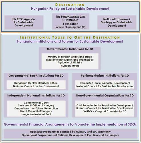
This framework is fully described in the Sustainability Bodies in Hungary publication of the National Council for Sustainable Development, given in Hungarian.Footnote2 However, the reader is advised to study a shorter description in English which is available in the Voluntary Review, Hungary (Report Hu, Citation2018). Another source of information in English is available at the website of MFTTT.Footnote3
2.3. Hungarian GI and EO professional background in service of SDGs
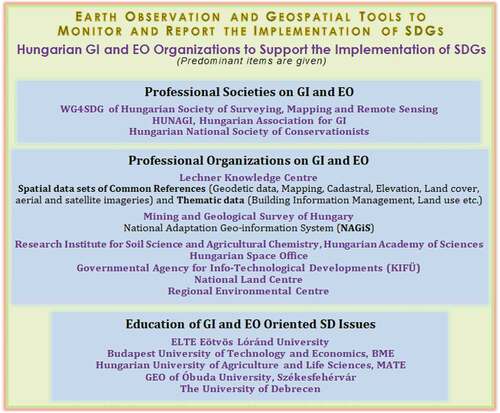
Non-profit civil societies, education organizations and professional organizations (research and development institutes, governmental organizations and enterprises) are outlined in . Their details mainly in connection with their SDGs-oriented data services and actions are discussed in Chapter 5.
Figure 2. Hungarian GI and EO organizations facilitating the sustainability
3. Achievements of the WG4SDG participating in international forums and domestic activities
3.1. Partnership on international level
In the case of MFTTT WG4SDG, the involvement in international activities is twofold:
to leverage information gained from the most authentic sources on advances and best practices in the use of the huge volume of GI/EO data, and the applicable services to support SDGs’ indicator monitoring and reporting, and,
to share the information with the stakeholders (institutional entities and professional communities) regarding data management and Earth observation information infrastructure developments and services. The purpose is to encourage them to engage with and support the implementation of the SDGs of the UN 2030 Agenda for Sustainable Development (IISD SDG, Citation2016).
The engagement of WG4SDG with the communities of acknowledged actors offers the opportunity to evaluate and strengthen our domestic actions, and to support the work of the international community. Feedback and fresh insights will allow Hungary to be aware of trends and to refine our approach.
Although the golden triangle (government, industry and academia) is under the spotlight, special attention will be paid to NGOs, as well as to local governments and citizens. We wish to empower all players to act as local knowledge custodians and accomplished citizen science actors. These tasks will require ongoing concerted actions in capacity building, provided by the higher education institutions, professional societies and an inspired private sector.
3.1.1. Some key actors followed by MFTTT members in the EO/GI for SDGs
3.1.1.1. GEO
Hungary joined Group of Earth Observations (GEO) in 2006 as the 65th member of this intergovernmental organization. Two founding members of WG4SDG served as national GEO correspondents, and one of them was delegated to GEO by FÖMI, the former Institute of Geodesy, Cartography and Remote Sensing, the flagship of EO/GI institution in Hungary providing data, information, services and solutions in land, agriculture and environment domains at that time. Other member of the GEO National Board was delegated to GEO by the Global Spatial Data Infrastructure Association (GSDI) (2006–2018), later by the Hungarian Space Office (HSO), actually the Department of Space Activities at the Ministry of Foreign Affairs and Trade (MFA). The established link and cooperation between the Hungarian GI Community and the GSDI Association was enabled by the European Umbrella Organization of Geographic Information (EUROGI) and by the proactive role of HUNAGI in the mid 90’s (Remetey, Citation2020). This GSDI link provided opportunity to closely follow GEO’s recent 15-year evolution, including its Big Earth Data infrastructure GEOSS, the Global Earth Observation System of Systems (Craglia, Hradec, Nativi, & Santoro, Citation2017).
3.1.1.2. GEO EO4SDG
During 2015–2020, the MFTTT WG4SDG member joined the GEO plenary and ministerial level meetings on behalf GSDI and took part on GEO Common Infrastructure Workshop, the GEO Work Program Symposium and GEO Data and Technology Workshop as well. Associated side events attended include the ESRI Conference on Geographic Information System (GIS) apps for SDGs. In May 2016, the GEO Initiative-18 on Earth Observation for SDGs (EO4SDG) decided to launch the monthly teleconferences among its core experts from NASA, the European Space Agency (ESA), Center for International Earth Science Information Network (CIESIN), National Space Research Institute of Brazil (INPE), National Institute of Statistics and Geography of Mexico (INEGI), as well as special bodies of the United Nations Statistical Division (UNSD) such as the Inter-Agency Expert Group on SDG (IAEG-SDI), Working Group for Geospatial Information (WGGI) and the advisory board on Global Geospatial Information Management (GGIM), inviting acknowledged partners including GSDI, later MFTTT WG4SDG as well. Today, besides UN-GGIM, GEO EO4SDG are serving as key information sources facilitating the awareness raising campaign ‘GI/EO data for SDGs’ in Hungary. Documents elaborated by ESA, Committee on Earth Observing Satellites (CEOS), International Federation of Surveyors (FIG), International Cartographic Association (ICA), International Society of Photogrammetry and Remote Sensing (ISPRS), Committee on Data for Science and Technology of the International Science Council (CODATA), Sustainable Development Services Network (SDSN), Global Partnership for Sustainable Development Data (GPSDD), International Institute on Sustainable Development (IISD) and European Forum of Geography and Statistics (EFGS) are equally beneficial to share best practices and policy issues. The GEO EO4SDG Initiative becomes a focal point for coordination across the GEO community related to EO in service of the accomplishment of SDGs (Kavvada, Citation2018), while ICA emphasizes the role of mapping for SD (ICA, Citation2020).
3.1.1.3. CEOS WGISS
Similarly, the working connection between GSDI and CEOS – the satellite arm of GEO – was established 15 years ago in Budapest via the CEOS Working Group on Information Systems and Services (CEOS WGISS). During the past several years, the liaison reports presented in GSDI-WGISS (and later HSO-WGISS) relations enabled sharing updates on the MFTTT WG4SDG campaign at the plenary meetings hosted by the space and governmental agencies e.g. ESA, NASA, the Russian Space Agency (Roskosmos), United Kingdom Space Agency (UKSA), Geoscience Australia, Institute of Remote Sensing and Digital Earth (RADI, today Aerospace Information Research Institute of the Chinese Academy of Sciences), Space Agency of Japan (JAXA), and the National Oceanographic and Atmospheric Administration (NOAA). These meetings offered excellent opportunities to collect information on lessons learned best practices on EO big data-related solutions in discoverability, accessibility, stewardship and preservation of data, solutions in data architecture, production of analysis-ready data as well as technology exploration, use of cloud services. These plenaries provided insight into the work of the CEOS Ad-Hoc Team on SDG, CEOS Working Group on Capacity Development and CEOS System Engineering Office. The latter is contributing significantly to the availability and support of the CEOS Open Data Cube. CEOS member ESA highlighted the strategic importance of satellite Earth observations in support of the SDGs in a special edition report signed by chairpersons of UN-GGIM and CEOS as well as Director of ESA’s EO Programs (ESA, Citation2018).
3.1.1.4. ISDE
Although the International Society for Digital Earth (ISDE) was established in 2006, the close links with the series of International Symposium on Digital Earth goes back to 2003 via the Hungarian Association for Geoinformation (HUNAGI). After the UN 2030 Agenda for Sustainable Development was adopted by the UN General Assembly in 2015, an awareness raising campaign on SDGs has been started by MFTTT. The emerging issues related to SDGs were addressed also by the International Symposia on Digital Earth and the Digital Earth Summits, both organized by ISDE. The MFTTT WG4SDG presentation ‘Unlock and use EO/Geospatial data for SDGs by empowering stakeholder engagement in a transformed society’ was delivered at the 11th ISDE Symposium in October 2019. Contribution was made by invitation, at and after the virtual workshop discussion on ‘Digital Earth Vision 2030ʹ in July 2020, emphasizing the potentials of Digital Earth technologies to mitigate the coronavirus pandemic. The ISDE connection allows insight of the Digital Twin, the Big Earth Data concept (Guo, Citation2014), the exploitation and use of big data with novel Digital Earth technologies (Guo et al., Citation2017) and sharing solutions as these features and aspects are described in the Manual of Digital Earth (Annoni, Goodchild, & Guo, Citation2019; Guo et al., Citation2020). These tools and practices can accelerate the implementation of global policies such as Paris Climate Agreement, the Sendai Framework and the UN 2030 Agenda for Sustainable Development for the benefit of society, economy and sustainable environment. The Big Earth Data Program of the Chinese Academy of Sciences (CAS) paid special attention to SDGs (CAS, Citation2020).
3.1.1.5. IAG
MFTTT keeps close contact with the International Association of Geodesy (IAG). The Global Geodetic Reference Frame for Sustainable Development (GGRF), which is a realization of the Global Geodetic Reference System (GGRS), was adopted by the UN General Assembly (United Nations, Citation2015). IAG established the integrative Global Geodetic Observing System (GGOS) based on these components providing precise spatiotemporal information, which are fundamental for monitoring progress in accomplishment of the SDGs (United Nations, Citation2015).
3.1.1.6. ISC CODATA
The first link to CODATA (founded by ICSU, the International Council for Science – today ISC after the merge with the International Social Science Council) was established at the 12th CODATA Conference on Open Data and Information for a Changing Planet by delivering a presentation in the ISDE session “Digital Earth in Data-Intensive Era” in Taipei, China, 2012. The next occasion was MFTTT WG4SDG’s participation in discussion on “GI and Sustainable Development” at the 24th InterCarto-InterGIS organized jointly by ICA Working Group on SD/CODATA-Germany in Bonn, July 2018 with active participation of ISDE (Hernandez, Citation2018). Recently, the “Disaster Risk Reduction and SDGs Information Deficits” webinar hosted by CODATA Germany was promoted and participated in February 2021.
3.1.2. Outreach activity of MFTTT WG4SDG at international events
WG4SDG members delivered eleven (11) presentations and provided four (4) interventions at international conferences and meetings, by participation in person. These contributions include CEOS WGISS Meetings (Remetey et al. Citation2018, Remetey et al. Citation2019a; Kristóf et al., Citation2019), 11th ISDE Symposium (Remetey, Citation2019b), GEO Week 2018 Side Event of EO4SDG, , Conference on Cartography & GIS (Zentai, Mihály, Remetey-Fülöpp, & Palya, Citation2018), and Symposium of the German Aerospace Agency on New Perspectives of EO (Remetey et al., Citation2019c).
All presented papers are accessible in the WG4SDG document library on the MFTTT website (MFTTT, Citation2021). A spare document repository is maintained by the Institute of Cartography and Geoinformatics of Eötvös Loránd University (ELTE, Citation2021). Since 2017, updated reports have been submitted yearly to the Coordinating Secretariat of GEO EO4SDG on the activity of MFTTT WG4SDG.
Printed publications describe WG4SDG activities as published by international journals or conference proceedings include papers
dealing with the challenge of raising awareness of stakeholders (Remetey, Citation2017),
emphasizing the role of EO/GI/SDI for SDGs to engage the data custodians (Mihály, Remetey-Fülöpp, & Palya, Citation2017),
introducing the wide range Hungarian geospatial data and services ready to support the UN 2030 Agenda Implementation (Zentai et al., Citation2018),
giving a flashback, how the Hungarian Association for Geoinformation (HUNAGI) paved the way for the partnership of MFTTT with EO4SDG after the GEO XII Plenary in 2016 (Remetey-Fülöpp, Citation2020),
analyzing the role of land administration in the SDG’s success (Zentai, Iván, Mihály, Palya, & Remetey-Fülöpp, Citation2020).
3.1.3. Sharing calls and reports on relevant international events
The MFTTT WG4SDG practice of regular awareness raising and reporting on SDG-related events and opportunities was introduced in 2016 by following closely the activities of CEOS WGISS, GSDI, ISDE, GEO EO4SDG and engaged international campaigns such as Action4SDG or WeAct4SDG. Reports have been disseminated involving over thirty (30) events (RFG Napló, 2015–2021). As a recent example, the community were encouraged to access the learning hub of the UN System Staff College’s Knowledge Center on Big Data and SDGs, the webinars on the European and Open Data Cube Technologies, the Indicator Reporting Information System, and virtual session of the European Association of Remote Sensing Companies’ (EARSC) on leveraging EO services to help countries monitor the SDGs. Information on GEO Data Technology Workshop, GEO XIIth and XIIIth Plenary Meetings, GEO Week 2019 and GEO Surveys were disseminated. In cases when the event was not attended in-person, the contribution has been provided remotely. At the 2nd Nexus Conference on SDGs, the importance of data collaboration and partnership for the interdisciplinary approach of the interlinked multi-node environment of water, energy, food and climate was expressed by WG4SDG in written contribution. EO and geospatial data infrastructures with interoperable sectorial data services provide effective support for monitoring and reporting on indicators of the goals and targets of the UN 2030 Agenda for SD.
Due to the COVID-2019, meetings, workshops and conferences have been transformed to web-based virtual ones. At the 52nd Meeting of the UN Statistical Committee, an IAEG-SDG WGGI side event allowed insight of the three phases of the “SDG Geospatial Roadmap” (UNSD, Citation2021) and potentials of the “EO Toolkit for cities and human settlements” (Kavvada, Citation2021), where contributions are welcomed. Earth observation means here the integrated use of satellite, airborne and ground-based remotely sensed data, coupled with statistical, socio-economic and other relevant information, in a way which supports both the UN 2030 Agenda and the New Urban Agenda.
Recently, the Geospatial Knowledge Infrastructure (GKI) Summit was advocated for attendance. The 2-day webinar organised by the Geospatial Media and Communications group higlighted two themes: “Beyond geospatial: GKI redefining ecosystem” (with topics 4IReady Geospatial Platforms and Services, Data Partnership and Sharing Key to GKI, Integrated Policy Framework) and “Making Geospatial Knowledge Infrastructure a reality” (discussing “Transforming geospatial stakeholder ecosystem; role of standards and interoperability; co-creating Geospatial infrastructure and services; and Evolving business models”). EO-related calls were forwarded to the HUN-EO list, moderated by the Lechner Knowledge Center.
3.1.4. Sharing basic documents, publications and best practices for the domestic communities
Effective awareness-raising needs authentic sources for constructive information to be disseminated, which delivers insights that facilitate understanding and motivates eagerness to engage. The links with GSDI, GEO, CEOS, UN GGIM and scientific societies such as FIG, ICA, ISDE and ISPRS enables Hungary to have direct access to relevant information in real time. A complete listing of about 30 selected publications that range from policy documents to description of best practices, is available in downloadable form at the WG4SDG webpage (MFTTT, Citation2021). Emphasis was given to novel solutions, which support effective spatiotemporal assessment on analysis-ready data.
3.2. Activities on domestic level
The MFTTT’s GI/EO for SDGs campaign, which highlighted opportunities and challenges, was actually inspired by the GEO EO4SDG Initiative together with a paper describing a strategic framework for integrating a global policy agenda into national geospatial capabilities in the context of sustainable development and geospatial information written by UN-GGIM experts (Scott & Rajabifard, Citation2017). Accordingly, members of MFTTT WG4SDG delivered a series of presentations during the campaign as acknowledged and supported by the Executive Committee of MFTTT. In 2020, an awareness raising campaign was prepared to address relevant high-level decision-makers offering partnership in the monitoring and reporting of SDGs indicators as part of interdisciplinary cooperation based on the emerging EO/GI data infrastructure.
3.2.1 Presentations of WG4SDG members on advancements in the EO/GI for SDGs at domestic and cross-border events
About 30 domestic conferences and meetings offered opportunities for MFTTT WG4SDG to share information. These events include the “Day of the European Surveyors and Geoinformatics” (2017–2020), “GISOpen” (2017–2020, 8th Conference and Exhibition on Geoinformatics), Roving Conference of MFTTT and “Fény-Tér-Kép” Conference an Annual forum of experts in remote sensing, image processing, photogrammetry and geoinformatics. As cross-border event, the 18th Conference of the Hungarian Technical Scientific Society of Transylvania should be mentioned.
About 15 WG4SDG presentations were made at these conferences. They are accessible in the WG4SDG document libraries (ELTE TGI, Citation2021; MFTTT, Citation2021).
Two comprehensive MFTTT WG4SDG documents have been published so far in Hungarian by the journal “Geodézia és Kartográfia”:
The first paper referenced the UN 2030 Agenda for Sustainable Development and emphasized the challenge and opportunities Geospatial and EO communities. MFTTT has launched an awareness campaign with the aim to contribute to the implementation of the SDG targets 17.16 and 17.17 by promoting the partnership, cooperation and the engagement of the stakeholders (Mihály, Palya, & Remetey-Fülöpp, Citation2018); and,
The second paper is actually an Executive Summary of a WG4SDG working document focusing on the need of Geospatial/EO infrastructure, integrated with the statistical information to support the SDGs (Mihály, Citation2020; Remetey-Fülöpp, Citation2020).
Social media was used extensively to share information, knowledge, news and opportunities with the Hungarian EO/GI community. About 170 blog posts have been devoted to the topics EO/GI for SDG. These featured shared documents (20%), reports on events (18%), presentations (16%), calls/opportunities (9%), printed publications (6%), communications (4%) and others (27%) (RFG Napló, 2015–2021). Outside MFTTT, communities of HUN-EO and HUNAGI play dominant roles in Internet-based dissemination of GI and EO-related information for their members.
3.3. Communication with policy makers and prime stakeholders
Members of the MFTTT WG4SDG, who have seats on the Scientific Council of Space Research (an advisory board for MFA) had the chance to formulate EO-related recommendations for the national strategy of space research and activities. It is anticipated that the document will be ready for adoption in 2021.
According to the resolution of the MFTTT Executive Committee, the high-level decision makers of SDG-relevant ministries, governmental and non-governmental bodies and forums have been approached in the first Quarter 2021. Signed by MFTTT president Academician J. Ádám and WG4SDG chair Sz. Mihály, the letters introduce the MFTTT Society, the mission goals of its WG4SDG, calling attention on the importance of spatial thinking and role of geospatial data/EO information, both for the implementation of SDGs of the UN 2030 Agenda and the respective Hungarian National Framework Strategy for Sustainable Development. The introduced work done so far includes insights from international know-how and dissemination of information on best practices, as leveraged from accomplished global and regional organizations. The letter emphasized the vast amount and high quality geospatial and EO data available in Hungary, the related emerging infrastructure for geospatial data, and operational EO-based services. These data are most applicable for support of the indicator measurements, monitoring and reporting. This data infrastructure encourages the integration of geospatial data and the national statistical data that will greatly improve both efficiency and efficacy. Hungary, having recognized some weakness and bottlenecks, has made recommendations that formulated in-line with the National Framework Strategy for Sustainable Development to facilitate the successful achievement of the SDGs:
by institutional strengthening development and application of the national spatial data and EO information infrastructure,
by introduction of integrated use of geospatial data with the national statistical ones taking into account the geostatistical dimension of SDGs, the disaggregation by geographic location (Scott, Citation2017).
It was also advocated to invite EO/GI for SDG-related presentations to the “Planet Budapest 2021 Sustainability Expo and Summit” scheduled for 29 November and 5 December 2021. So far 19 governmental institutions and organizations have been approached. The first, proactive feedbacks arrived within days from the Ministry of Innovation and Technology, the Ministry of Foreign Affairs and Trade as well as the Ministry of Agriculture. This action and the related early developments will be reported as “country use case news” at one of the upcoming GEO EO4SDG ExCom teleconferences.
4. Higher education of geoinformation and Earth observation for sustainable development
4.1. General rules of accreditation of higher education programs and departments
The higher education systems in Europe have been undergoing a major transformation in the recent decades. This has been influenced both by national and international developments, i.e. one can observe the rapid expansion of student enrolment, the increasing importance of research and innovation as well as the wider competition and cooperation between higher education institutions. The Bologna process has had a particular impact on curricular reform, with quality assurance and mobility having become one of the major factors behind the changes.
In 2002, Hungary started to adopt the principles of the Bologna process (after signing the declaration in 1999). Governmental decrees introduced a new cycle system and qualifications framework for higher education. New procedures of founding and accrediting bachelor and master programmes were also introduced.
Although Hungary implemented the Bologna process concerning the higher education programmes, these regulations kept national characteristics. The most recent Higher Education Act (2011) regulates the establishment and operation of all Higher Education Institutes (HEIs).
The state-owned HEIs are accountable to, and receive funding from, the relevant ministry, whereas non-state HEIs can be established by churches, business organisations and foundations. All universities are authorised to offer Bachelor and Master programmes, but only programmes which were previously approved by the independent Hungarian Accreditation Committee.
The general outcomes of all approved programmes are regulated in a ministerial decree in accordance with the Dublin descriptors (this decree is updated when it is necessary, but not frequently). This system is less flexible, because the government would like to control the number of students in each programme. Every Hungarian citizen has the right to undertake studies in programmes, whether fully or partially financed, through scholarships granted by the Hungarian state, or tuition full paid. The first diploma, at both the bachelor and master level, can be state financed. This system of higher education programmes is more strictly for bachelor programmes. It is very difficult or nearly impossible to expand the list of BA/BSc programmes. Universities have the right to initiate these programmes. The government intentionally keeps the number of bachelor programmes at a low level, but the education system is more flexible at the master’s level. Still, when initiating a new master programme, the higher education institutions have to first acquire approval from the Hungarian Accreditation Committee and the Ministry. After the successful accreditation process, the programme will be added to the list of available programmes, and all universities manage their accreditation process of programmes at their institution.
4.2. Sustainability in the Hungarian education
The above procedure for accreditation is the main reason why we do not have a special bachelor or master programme on SDGs at this time. Nevertheless, if we check the most recent version of the decree on general outcomes of the university programmes (last released in 2016, but extended with new programmes at the end of 2020), the sustainable development goals are listed as part of the general outcomes in several bachelor programmes (including 15–30 credit modules or subjects):
Food Engineering,
Horticultural Engineering,
Nature Conservation Engineering,
Rural Development Engineering,
Agricultural and Business Digitalization,
Agricultural Water Management and Environmental Technology Engineering,
International Business Economics,
Energy Engineering,
Environmental Engineering,
Earth Science Engineering,
Chemical Engineering,
Nature Conservation Engineering,
Vocational Technical Instructor,
Engineering Management,
Geography,
Environmental Studies.
Due to the much larger number of master programmes, here are only a few of them: Agricultural Economics, International Development, Biotechnology, Environmental Science, and Cartography.
Doctoral programmes are much more flexible and the UN Sustainable Development Goals were implemented soon after their release, so that today, more and more SDG-related subjects were developed and added.
4.3. A planned CHARM-European university master degree programme
Based on the European Council Conclusions of (2017), the Member States, the Council and the European Commission to advance education are encouraging the emergence by 2024 of some twenty European Universities. These are universities across the EU which will enable students to obtain a degree in combining studies from several EU countries and support the international competitiveness of European universities as a result of developing joint education and research programmes and projects. European Universities are transnational alliances that will become the universities of the future, promoting European values and identity, and revolutionising the quality and competitiveness of European higher education. The results of the 2019 call were published in June 2019. Out of 54 applications received, the first 17 European University alliances involving 114 higher education institutions from 24 Member States were selected. 24 additional European University alliances were supported in 2020. In the 2019 call, five Hungarian universities were part of winning associations:
CHARM-EU (Reconciling Humanity with the Planet), Eötvös Loránd University
CIVICA (European University of Social Sciences), Central European University
EDUC (European Digital UniverCity), University of Pécs
EU4Art (Alliance for Common Fine Arts Curriculum), Hungarian University of Fine Arts
EUGLOH (European University Alliance for Global Health), University of Szeged
The CHARM-EU (Challenge-driven, Accessible, Research-based, Mobile European University) is a Consortium between the University of Barcelona (coordinator), Trinity College Dublin, Utrecht University, the University of Montpellier and Eötvös Loránd University Budapest (ELTE). The universities are working on the CHARM European University first inter- and multi-disciplinary programme, a Master in Global Challenges for Sustainability. During the very intensive programme development process, the universities should be able to solve any legal problems.
In Hungary, Eötvös Loránd University continuously inform the ministries and the Hungarian Accreditation Committee on this newly planned programme. Understanding the importance of the European Universities initiative, the ministerial regulations integrated the opportunity of such international joint programmes: the general outcomes of the MSc in Global Challenges for Sustainability will be released soon and will definitely allow ELTE to start this joint programme in September 2021. The MSc is aimed at graduates of any discipline seeking to acquire advanced knowledge of sustainability, by addressing global societal challenges, developing challenge analysis skills, and extending their capabilities to address and develop solutions for complex problems. Delivered full-time over 18 months, the 90 EC Master’s is comprised of 30 EC Preparatory Phase modules on sustainability, social innovation and transdisciplinary research; 30 EC Flexible Phase transdisciplinary modules related to Water, Food or Life and Health; and a 30 EC Capstone on a sustainability challenge in collaboration with extra academic actors (i.e. business, community and society). This overall structure will attract high-quality graduates from diverse relevant backgrounds who intend to work in sustainable policy and communication roles, social innovation and action either within existing companies (intrapreneurship) or via generation of new enterprises (entrepreneurship), and academic research in this area.
The programme already obtained a European accreditation in January 2021, which should be accepted in all EU countries, so the Consortium can start the promotion of the master programme. See https://www.charm-eu.eu/for more details.
4.4. Aspects of SDGs at the Budapest University of Technology and Economics (BME)
The University of Technology and Economics, founded in 1782, is the oldest technical university in Europe. The traditional faculties (Civil Engineering, Mechanical Engineering, Architecture, Chemical Technology and Biotechnology, Electrical Engineering and Informatics) focus on the technical aspects of the given disciplines.
In the 1970s, the education and research staff of BME introduced a “new scientific paradigm” which was called remote sensing and natural resource management. In 1980, Bertalan Farkas, the first Hungarian astronaut was launched into space on Soyuz 36 spacecraft. While in orbit Mr. Farkas conducted experiments in Earth Observation. After returning to the Earth, he joined the research staff of the BME Photogrammetry and Remote Sensing group working to support the Earth Observation applications.
After the 1990 transition two new faculties were founded (Natural Science, Economics and Social Science) to widen the profile of the BME and to focus on the environmental, social and economic factors of the engineering interventions. In the 21st century curricula was refreshed at BME and regular Remote Sensing and Geoinformatics courses were introduced not only for Civil Engineering education. In the first decade the Applied Geoinformatics courses were introduced at the undergraduate level for the Engineering Management and Regional Development students of Economics and Social Science Faculty as well as for the Environmental Engineering students of Chemical Technology and Biotechnology Faculty. All the curricula of these courses were strongly based on EO technology and the availability of open GI information systems World-wide, Europe and Hungary (i.e. optical and radar remote sensing products, EU Copernicus global, regional, local datasets, CORINE, Urban Atlas, SRTM, EU-DEM, OSM).
Environmental, social and economic sustainability were permanently supported, but after the announcement of the UN SDG Agenda, the courses were oriented to support a connection between the UN SDG Goals and the Engineering intervention. In 2019 the Faculty of Architecture started a new MSc specialization course titled “Sustainable Urban Development”, where a course named “Digital Cities” was introduced to the students for the application of EO materials and methods. Altogether there were approximately 500 BSc, MSc, PhD and 30 postgraduate students studying in BME yearly who acquired knowledge and skills about EO applications for sustainable planning. Every year about 60 of these students come from developing countries, so BME supports the provision of capacity building for developing countries in the conduct and use of sustainability research.
The Civil Engineering EO-based education changed the traditional planning methods to environment reflected design technique. The Environmental Engineering EO-based education extended traditional lab oriented, point like in-situ observations to complex environment analysis, impact assessment.
In the frame of Economics Regional Development EO based education we taught the students how to balance the technical, environmental and social domains.
The Architecture programme for Sustainable Urban Development EO based education changed the traditional linear planning methods to complex multidomain analysis and real-time impact assessment.
The Faculty of Electrical Engineering and Informatics founded a new MSc program “Space Engineering” in 2021, focusing for the upstream segment of space activity. Areas of interest include the engineering of space missions, space vehicles and instruments, sensors, actuators, mechanisms, propulsive means, vehicle control, distributed space systems, and systems engineering. This will all be part of the regular education starting in 2022.
This exemplifies how the BME teaching staffs provide the students with professional knowledge and skills to understand the importance of implementation of the SDG solutions.
4.5. EO/GI research activity at the Budapest University of Technology and Economics
The research activity of the BME was traditionally focusing for the downstream space technology. Under the Soviet Regime an INTERCOSMOS research group was working in the field of natural resource management.
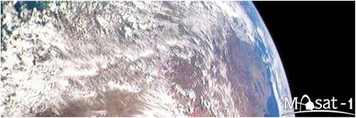
In 2012 the BME joined to the upstream space activity, with the first indigenous Hungarian satellite, “MaSat-1” developed and built by students at the BME supported by the ESA. The 1 U CubeSat-type satellite (sizes 10x10x10 cm, maximum weight 1 kg) was launched into a low Earth orbit on 13 February 2012. The satellite provided telemetric data as well as VGA resolution colour images at the 70 cm amateur radio wavelength (437.345 MHz frequency) received at the tracking centre at BME, Budapest (see ).
Figure 3. The first Masat-1 CubeSat captured photographs from space on 14th of March, 2012
BME managed the “Space Forum” as an umbrella to coordinate and harmonize the department’s space activity and build a bridge between academic researches, production, service applications. The Space Forum coordinated and assisted the following (Kovács, Citation2017):
the integration of human resources, infrastructure capacities and internal knowledge sharing in the field of space technology and space research of BME,
the definition and representation of the directions and key programs of BME space activity,
the formation of research partnerships and industrial cooperation by joint objectives and R + D directions,
external knowledge and technology transfer processes, primarily to strengthen domestic space industry,
in the area of space research and space technologies, the development of education-training for developer supply primarily at the technical University, but at any level of education-training,
the promotion of space activities, raising awareness of its importance,
BME participation at key domestic and international space research and space technology projects and tender applications.
Under the umbrella of the Civil Engineering Faculty a Knowledge Centre for Water Sciences and Disaster Prevention was founded in 2019 to support the water science and disaster prevention applied the EO supported sustainable development.
The BME staff actively worked in the ISPRS Intercomission Working Group III/IVb, in the Remote Sensing Data Quality group. The goal of WG was to assess the current status of scientific development and applied practices, related to Remote Sensing Data Quality and to suggest development plans, researches, activities and projects for the improvements. The main activity of the WG was to support the reliable, wide applications of the remote sensing data sources for non-remote sensing experts (Albrecht, Citation2018; Barsi, Citation2019; Batini, Citation2017).
The Geoscience PhD program of the BME covers a wide range of Earth-related scientific topic. One of them is the Land Use Optimization based on National Spatial Data Infrastructure, focusing the EO based sustainable urban development for Bangladesh (Rahman, Citation2020).
The BME research staffs provide evidence-based solutions, technological workflows and innovations to support the implementation of the SDGs, applied interdisciplinary collaborating knowledge and involved the community. The university continually researches, educates, demonstrates and broadly communicates the importance of SDGs.
4.6. Sustainability in the Educational University Curricula of Landscape Architecture Institute
At the Landscape Architecture Institute of the Hungarian Agricultural and Life Sciences University (MATE) there are subjects that directly focus on issues of sustainability:
Animal feeding and Environment protection,
Sustainable landscape design and planning,
Nature protection,
Water management,
Management of Urban green spaces.
The education in connection with sustainability involves the goals, the targets and the indicators jointly in the SDG-topics of
agriculture, landscape design and management-related issues,
maintaining biodiversity in urban areas,
support urban planning and development
and public participation in environmental and urban decision-making.
There are other departments of the Hungarian Agricultural and Life Sciences University (MATE) which apply the Agenda 2030 on SD in their university curricula focusing particularly on the proper animal and plant management which concerns several SDGs.
As an example, we can mention that in “Animal feeding and Environment protection” subject, where the students learn that special animal diets can positively affect the digestion cycle of cattle and with this special feeding, the nitrogen dioxide, carbon dioxide and phosphorus emissions can be reduced substantially.
A survey of the students at the University made evident that they are very enthusiastic about learning and applying SDG principles. The young generation is greatly concerned about climate change. They are ready to put more effort into environment preservation and air quality control. They also realize that the natural resources of the globe are being depleted and want to see broader usage of renewable energy. The courses that deal with principles of SDG are rather popular and even doctoral students’ research topics deal with ecological settlements (eco-village).
The term “sustainability” has been around for almost a decade in the scientific world, some people may think this topic is outdated. However, it may sound surprising, but students and the younger generation in general is more keen about maintaining sustainable land, agriculture and lifestyle, especially given their future depends on effective implementation of the SDG objectives and goals.
The MATE research agenda to support urban planning and development helps the scientific world to support the transition of the traditional industrious cities into sustainable and liveable areas. Consequently, the following issues must be addressed:
(a) definition of general principles and concepts of urban landscape ecology,
(b) the impact of biotic and abiotic conditions on plant and animal diversity in cities,
(c) the role of urban plant and animal species as indicators of the quality of urban nature,
(d) development of (landscape) ecological models applicable in urban environments,
(e) understanding of urban land use/cover development,
(f) and conservation concepts for urban biodiversity.
The above mentioned criteria are actively addressed in the university curricula. For example, the first criterion is analysed in detail in Animal feeding and Environment course, where proper animal feeding and diet can reduce methane emissions, which are a significant component of greenhouse effect.
The second criterion is addressed in the subject named Management of Urban green spaces. It discusses how the proper selection of urban tree species, which are more resistant to the pollution and heat, and can reduce negative effects of climate change.
5. Overview of the Hungarian EO and GI data services to support implementation of SDGs
In this chapter an overview is given on the major mapping, geoinformation and Earth observation data and services in Hungary as well as on their embedding into the European spatial data infrastructure INSPIRE. As a case study, the Hungarian soil GI system is presented explicitly.
5.1. On the major mapping, geospatial and Earth observation data and services
5.1.1 Professional organizations
The supervisory authority in the field of surveying, mapping, remote sensing, lands and geoinformation is the Department of Land Administration and Geo-information of the Agricultural Ministry (LandGIHU, Citation2018). The major projects in Earth Observation as part of space industry and research is supervised by the Ministry of Foreign Affairs and Trade.
The major sectors having GI and EO capabilities and playing dominant roles in implementation of SDGs are the Water Management, Transportation, Meteorology, Geology and Geophysics, Energy, Soil, Environment Protection and Nature Conservation, Physical planning, etc. Detailed presentation of the respective institutions is out of scope of this paper.
The private sector operates with GI and EO. They can be potentially involved into the implementation of SDGs taking an active part in the target and indicator monitoring and/or reporting. The Cluster of Hungarian Space Industry plays here a special role.
5.1.2 Organizations with dominant roles
There are two professional organizations playing dominant roles in supplying of common reference spatial data and thematic spatial data and basic monitoring GI and EO systems and considerable SDGs applications:
the Lechner Knowledge Centre,Footnote4 a common successor of
the Mining and Geological Survey of HungaryFootnote8 affiliation NAGISFootnote9; Official portal: NAGIS (Citation2018).
5.1.1.1 Lechner knowledge centre
The Lechner Knowledge Centre is handling and supplying the common reference and some thematic spatial data, data for physical planning, remote sensing, EO as well as big data applications for GI analyses of phenomenon being important for SDGs implementation monitoring:
Data and elements of reference systems;
Geographical names;
Administrative boundaries;
Unified National Cadastre cadastre map and immovable property registry;
Topographic maps;
Elevation data, DEM;
Aerial photos and orthoimagery: new and archived, digital, online service;
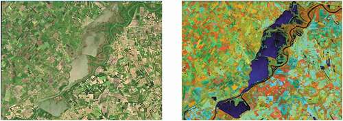
Monitoring of waters and floods, damages to agricultural production by using remote sensing ( is an example of two Sentinel imagery analysis);
Figure 4. Hungarian lake on Tisza River, May 2018, Sentinel-2 satellite imagery in true colour and false-coloured infrared
GIS Register and monitoring of Vineyards;
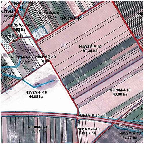
LPIS-Hu, Hungarian Land Parcel Identification System (Csornai, Bognár, Mikus, Wirnhardt, & Mihály, Citation2009), yearly registering and monitoring system to support farmers area-based subsidy, EU Common Agricultural Policy (now operated by National Land Centre); Details of LPIS-Hu see in (FFT.BFKH Portal, Citation2018);
Figure 5. Fragment from the Hungarian Land Parcel Identification System
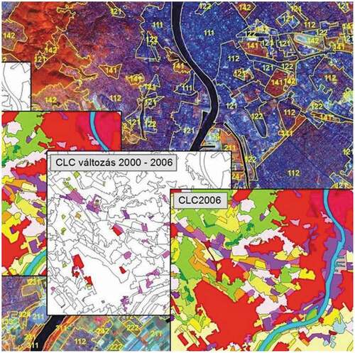
CORINE Land cover databases, reference year 1990 and updates 2000, 2006, 2012 and 2018; shows interpretation of land cover status in 2000 and 2006 (FFT.BFKH Portal, Citation2018);
Figure 6. Comparison of details of CORINE Land Cover status between 2000 and 2006
Building Information Management;
National Regional Development and Country Planning Information System, TEIR;
Electronic support system for regional planning, E-TÉR;
Electronic public utility information system, E-KÖZMŰ;
Web browser Copernicus, etc.
5.1.1.2 Mining and geological survey of Hungary
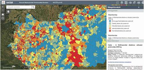
The Geological and Geophysical Institute of Hungary (predecessor of Mining and Geological Survey of Hungary) established the National Adaptation Geo-information System, NAGiS (in Hungarian: NATéRFootnote10) in a project supported by a grant from Iceland, Liechtenstein and Norway. It is a multipurpose geoinformation system that facilitates the policy-making, strategy-building and decision-making processes related to the impact assessment of climate change and founding necessary adaptation measures in Hungary.
A lot of “energy-climate-land-environment-change” type cross relations for very different epochs of tens of years can be expressed for SD analysis. One of them is presented on .
Figure 7. Global change potential of land use till the year 2050 including 5 categories
NAGiS may directly support the implementation, supervision and evaluation of the second National Climate Change Strategy as well as the implementation and evaluation of the Environment and Energy Operative Programme. It is a big data management to provide information for central, territorial and local administration and municipalities for sectorial and territorial planning in the fields of
climate and energy policy,
transport and infrastructure,
development,
agriculture, rural development, forestry,
territorial, municipal, regional planning,
public service management,
tourism, health and life quality,
disaster prevention and management.
The features of the data sets, applications and data services of the above major player of GI/EO support for SDGs implementation will be presented here later.
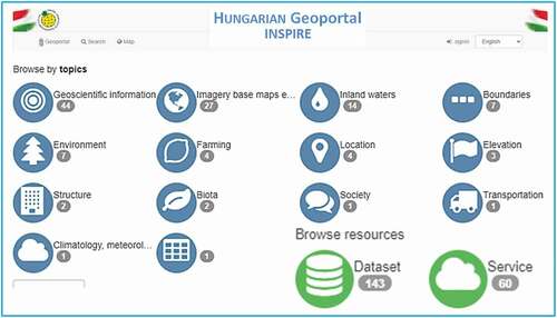
5.2. Impact of INSPIRE in Hungary
The purpose of Directive 2007/2/EC – known as the INSPIRE (Infrastructure for Spatial Information in Europe) Directive – is to lay down general rules aimed at the establishment, management and maintenance of the Infrastructure for Spatial Information in the European Community and of its computerised, Internet-based services, and to establish this infrastructure until 2021 in order to ensure that the enforcement of Community policies, the coordination of the activities that have an impact on the environment, and the management of, and feedback from, the political mechanisms of action are smooth, simple and efficient.
The INSPIRE Directive aims to create a European Union spatial data infrastructure for the purposes of EU environmental policies and policies or activities which may have an impact on the environment. This European Spatial Data Infrastructure will enable the sharing of environmental spatial information among public sector organisations, facilitate public access to spatial information across Europe and assist in policy-making across boundaries.
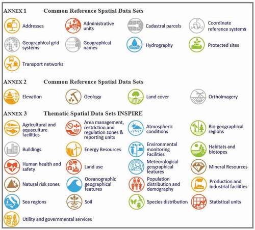
INSPIRE is based on the infrastructures for spatial information established and operated by the Member States of the European Union. The Directive addresses 34 spatial data themes needed for environmental applications – see .
5.2.1. INSPIRE directive*Footnote11
The development and functioning of the information society requires the establishment, processing and use of immeasurable amounts of data. Spatial information is a tool of the information society which plays a crucial role in the improvement of processes and modernisation of services worldwide. The objective of the National Spatial Data Infrastructure (NSDI) is to systematise the tasks of this specific field. The development of the NSDI is especially timely in terms of the necessity to join the INSPIRE programme, i.e. the European spatial data infrastructure action.
A significant proportion of the data generated in the public sphere is data that can be related to spatial location, i.e. spatial data. In Hungary, these spatial data currently belong to more than one ministry or ministerial support institution. The harmonisation of these spatial data is incomplete and cooperation between the databases is a problem; therefore, we must establish the NSDI, one basic element of which is INSPIRE.
Hungary is in the backdrop of implementation of the NSDI and the INSPIRE compared to EU Member States. Currently, Hungary does not have a nationally harmonised NSDI. Each field manages the data within their own scope of action in accordance with the legal requirements but no rule is in force regarding their harmonisation.
Therefore, it needs to establish a standing committee to steer the operation of the NSDI in order to ensure a more efficient use and harmonisation of the national spatial data and spatial information systems and in order to establish the NSDI itself.
With the exception of certain data themes, the Hungarian data policy does not allow free data uses at the moment. This prevents cooperation between the different sectors of the State several times because the funds necessary to pay the data supply service fee are often missing.
Another obstacle is that the land administration sector does not receive funds from the central budget, which forces this sector to cover the costs of operating, maintaining and improving the land administration system from data sales revenues.
The INSPIRE Directive plays an important role in the establishment of the NSDI of Hungary. The creation of a supporting Committee is necessary for the establishment of the NSDI, for the monitoring of its operation and for the related reporting tasks of SDGs. is an abstract of the Hungarian INSPIRE metadata portal.
Figure 9. Hungarian INSPIRE metadata portal. Source: www.inspire.gov.hu
The NSDI is the entirety of the spatial data, spatial information systems and registries managed by the State. The establishment of the NSDI will allow an efficient and coordinated use of the spatial data and spatial information systems by the Government, which is indispensable for ensuring proper decision-preparation, for managing emergency situations, for establishing a better environmental status, for improving the quality of State services and for establishing a better service-providing State, which support of the SDGs. Establishment of the NSDI is necessary on the governmental level with the cooperation of the different Ministries and the Hungarian Central Statistical Office, with the involvement of the academy, the educational institutions, the private sector and the civil society organizations. It needs at the same time implementing a more favourable data policy at the national level.
5.3 Case study: SOIL
5.3.1. SDGs and soils
However, for most SDGs, there is no direct link with soils, certain SDGs focus clearly on the biophysical system, in which soils play a clear role. SDGs 2, 3, 6, 11, 13, 14, and 15 refer to targets, which commend direct consideration of soil resources. Food security (SDGs 2 and 6), food safety (SDG 3), land-based nutrient pollution of the seas (SDG 14), urban development (SDG 11), and sustainability of terrestrial ecosystem services (SDG 15) are all depending on the provision of ecosystem services, where soil properties and functions play a key role to deliver these (Tóth, Hermann, Da Silva, & Montanarella, Citation2018). SDG target 15.3 on land degradation neutrality (LDN) mentions most directly soil in the form, “to combat desertification, restore degraded land and soil, including land affected by desertification, drought and floods, and strive to achieve a land degradation-neutral world”. In addition, soils play an important role in mitigating and adapting to climate change (SDG 13). Further, SDGs 7 and 12 will indirectly rely on the availability of healthy soil resources. Regarding the remaining SDGs, linkages can be found to the sustainable management of soils to some extent (Keesstra et al., Citation2016). As a consequence, to achieve the SDGs, there is an urgent need to assess and monitor the soil properties that impact soil productivity and the soil threats, with an emphasis on soil hydraulic properties, nutrient status, pollution, soil biodiversity, and Soil organic carbon (SOC) changes. An overarching concept of soil has been established by McBratney, Field, and Koch (Citation2014) namely soil security, where security is used for soil in the same sense that it is used widely for food and water.
SDG15.3 aims to achieve LDN, a state whereby the amount and quality of land resources, necessary to support ecosystem functions and services and enhance food security, remains stable or increases within specified temporal and spatial scales and ecosystems. To support these goals, the spatial assessment of land and soil degradation is necessary, which requires adequate information provided by Earth Observation together with reliable ground truth data and advanced GIS tools to elaborate relevant and reliable spatial information to support decision-making (Pásztor, Citation2021).
5.3.2. The renewed national spatial soil data infrastructure in Hungary
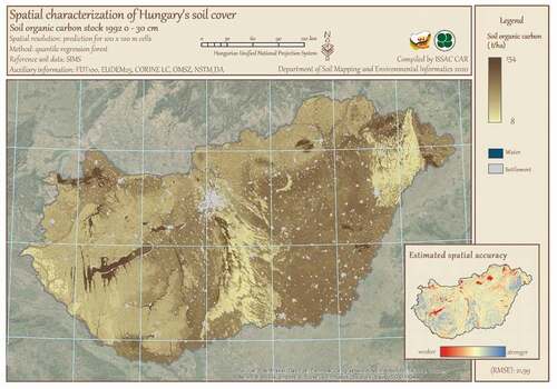
The GlobalSoilMap initiative (Arrouays et al., Citation2014; Sanchez et al., Citation2009) significantly inspired the DOSoReMI.hu (Digital, Optimized, Soil Related Maps and Information in Hungary) project (Pásztor et al., Citation2017), which was started intentionally for the renewal of the national spatial soil data infrastructure in Hungary. The main objectives of the work have been to broaden the possibilities, how demands on spatial soil-related information could be satisfied in Hungary. Primary and specific soil property, soil type and certain tentative functional soil maps were compiled. The set of the applied digital soil mapping techniques has been gradually broadened incorporating and eventually integrating geostatistical, machine learning and GIS tools. Soil property maps have been compiled partly according to GlobalSoilMap.net specifications, partly by slightly or more strictly changing some of their predefined parameters according to the specific demands on the final products. The main result of DOSoReMI.hu is a collection of spatial soil information in the form of unique digital soil map products, which were optimally elaborated for the regionalization of specific soil features. Significant part of them were never mapped before, even nationally with high (~1 ha) spatial resolution (Pásztor et al., Citation2018). Map production was neither formerly supplemented by accuracy assessment. The map products are published on the www.dosoremi.hu website, at the moment only in Hungarian, in two different ways. In the atlas version (), map layouts are collected and published for application as graphical elements with fully open access even for downloading. This map is supplemented with metadata on its compilation as well as an inset map for the expression of local uncertainty.
Figure 10. Layout of a novel, digital soil property map. Source: www.dosoremi.hu
5.3.3. Supporting LDN assessment by soil organic carbon stock mapping
United Nations Convention to Combat Desertification (UNCCD) is the custodian agency for SDG indicator 15.3.1. Information on this indicator has been regularly collected by the UNCCD through its national reporting and review process since 2018, and every four years thereafter (https://knowledge.unccd.int/ldn/ldn-monitoring/sdg-indicator-1531). Strategic objective 1 of UNCCD aims to improve conditions of affected ecosystems, combat desertification/land degradation, promote sustainable land management, and contribute to LDN. The indicator “Proportion of land that is degraded over total land area” (SO1) is compiled from three sub-indicators: “Trends in land cover” (SO1-1), “Trends in land productivity or functioning of the land” (SO1-2), “Trends in carbon stocks above and below ground” (SO1-3). SOC stock can be adopted as the metric of SO1-3, until globally accepted methods for estimating the total terrestrial system carbon stocks will be elaborated. UNCCD provides default data of SOC stock based on global databases; however, country-specific estimation based on higher resolution, more reliable and regionally more appropriate national data is strongly recommended to be replaced with.
Hungarian SOC stock maps were compiled in the framework of DOSoReMI.hu initiative, predicted by proper digital soil mapping (DSM) method (Szatmári et al., Citation2019). Reference soil data were derived from a countrywide monitoring system. The selection of environmental covariates was based on the SCORPAN model (McBratney, Mendonça Santos, & Minasny, Citation2003). The elaborated SOC stock mapping methodology have two components: (1) point support modeling, where SOC stock is computed at the level of soil profile, and (2) spatial modeling (quantile regression forest), where spatial prediction and uncertainty quantification are carried out using the computed SOC stock values (Yigini et al., Citation2018). We analyzed how SOC stock changed between 1998 and 2016. Nationwide SOC stock predictions were compiled for the years 1998, 2010, 2013, and 2016. For the intermediate years, we do not recommend to calculate SOC stock values, because we have no information on the dynamics of change in the intervening years. Based on the 1998 SOC stock prediction, we compiled a SOC stock map for 2018, using only land use conversion factors, according to the default data conversion values. According to the elaborated scheme during the respective period, significant changes cannot be detected; only tendentious SOC stock changes appear. Based on our results, we recommend using spatially predicted layers for all years when data are available, rather than calculating SOC stock change based on land use conversion factors.
6. Utilization of Earth observation data in Hungary a way to big Earth data era
6.1. Innovation: Earth observation information system data infrastructure and services
The groundwork of the “Development of the Earth Observation Information System data infrastructure and services” project was established in 2016. According to the project’s primary orientation, it aims to provide dedicated data downloading, processing, storage, and archiving, using the options provided by the ESA, and to also implement applications and services based on the stored data. The aim to the development of these service is to deploy Earth observation services for national users that can be used to assist in the implementation of official tasks in the field of public administration, the reduction of enterprises’ administrative burdens, the provision of Earth observation data to technical authority systems, as well as value-added data to a profit-oriented entrepreneurial clientele.
The implementation of the project was commenced in 2017, while hardware procurement started in the spring of 2019. The development of the software environment necessary for the operation of the project took place from the fall of 2018 through the fall of 2020. The system is currently in its testing phase, with public operations expected to go live in April 2021.
The project consortium is led by the Kormányzati Informatikai Fejlesztési Ügynökség [Governmental Agency for IT Development]. Consortium partners include Lechner Tudásközpont Nonprofit Kft [Lechner Knowledge Center Non-Profit Limited Liability Company], NISZ Nemzeti Infokommunikációs Zrt [NISZ National Infocommunications Private Limited Company], and the Ministry of Foreign Affairs and Trade. Another seven professional organizations participate in the project implementation as collaborators.
The project’s key priority is to furnish Earth observation remote sensing data to be used in administrative processes. The project has brought about a paradigm shift in the downloading, storage, processing, and provision of such images recorded by Sentinel-1, Sentinel-2, Sentinel-3, and Sentinel-5P that are related to the territory of Hungary: in marked contrast with earlier ad hoc and uncoordinated data usage, it supports alignment with the European Union’s programs via continuous, near real-time (NRT) downloading, recursive storage, processing based on automated processes, and distribution between organizations. In addition to the digitalization of administrative processes, the Earth Observation Information System facilitates Hungary’s preparation for the European Union’s changes in agricultural policy, set to implement in the 2021–2027 period.
In addition to serving administrative purposes, building on the contents of the “Copernicus Space Component – ESA – Hungary Technical Collaborative Arrangement”, concluded between Hungary and ESA in November 2019 for the support of small- and medium-sized enterprises, the storage system developed in the project can be used to store and provide access to the satellite images taken of Hungary earlier as part of the Copernicus program, as well as those to be taken in the future. The images are publicly available free of charge, after a simple registration process.
In order to provide wide-ranging access to the results of the Copernicus program that pertain to the territory of Hungary, the project provides access to the end products generated according to schedule, partly by way of the quality control of the received data, the pre-processing of the optical satellite images, making accessible the results of the polarimetric pre-processing, and through the co-registration of satellite images. With the help of the available processing capacities, we provide real-time access to 10 band combinations and five indices types. Based on the needs of the sectors, automated processes are used to perform both grid-based and vector-based data processing.
6.1.1. Major issues in developing the system
When developing the hardware and software environment, the possibility for flexible expansion is an important aspect, in addition to creating the greatest possible computing capability. When developing the service functionalities, and the software environment on which those services are based, the developer is required to ensure compliance with industrial standards, flexible expandability, and the use of open-source code tools.
In its present configuration, the HPE equipment procured during the course of the project contains a total of 1,128 CPU cores supplemented by 2 TESLA graphics cards with 5,120 CUDA GPU cores each. 8,000 GB of RAM are available for processing and the server system; data storage is geo-redundant and is provided by 2,200 TB of storage space and 4,800 TB of archiving space located at two separate sites. The administrative sub-systems are accessible via the governmental cloud service. All elements of the system can be further expanded as needed
The various end products are a result of automated processing chains. In the interest of supporting administrative procedures and of guaranteeing that the end products can be used as evidence, the algorithms used to create the product are also saved, meaning any earlier products can be recreated at any time.
The system provides a possibility for developing and testing new processing algorithms. Among others, this includes processing supports SNAP Sentinel Toolbox, GDAL libraries, ENVI + IDL, ENVI SARScape, Sen2core and BINGO. The publicly accessible eFöld (eEarth) portal enables searches for Sentinel satellite images of Hungary, as well as the downloading of indices and band combinations created for those in real time. It also allows members of the public to launch administrative procedures using e-forms. Online administrative interfaces and dedicated data transfer channels have been developed for the various stakeholders. The system’s operation is illustrated in .
Figure 11. The theory of the system operation
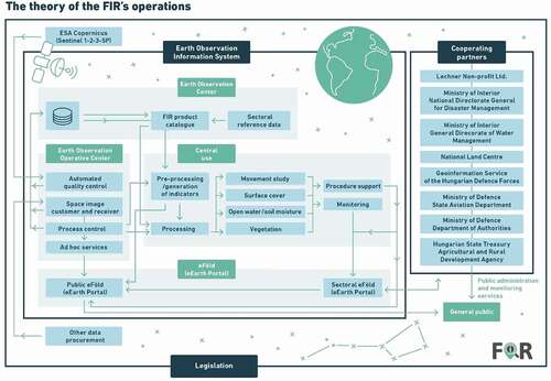
The system will be operated by the Földmegfigyelési Operatív Központ (FOK) [Earth Observation Operative Center]. When developing the FOK, we will create an independent hardware and software environment that can be used to create additional value-added services (such as special processing) based on the end products of the project.
Developing the electronic administrative services, the public administrative services launched with the Earth Observation Information System, has been integrated with the available central governmental IT services (e.g. identification and e-payment services).
6.1.2. Results achieved
The project’s development phase has been successfully completed and now runs as a test system. The system is expected to start a test run available to the public in April 2021.
The most important task to be carried out as part of the project is support of public administrative tasks using remote sensing data; accordingly, the project directly supports 10 administrative processes through the digitalization of procedures and the creation of end products for digitalized processes. This is in addition to the digitalization of ad hoc airspace designation and the aerial remote sensing licensing procedure, support was provided to the forestry (3 processes), the agricultural (2 processes), and the disaster management (3 processes) sectors.
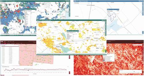
As a result of the cooperation with the sectors realized during project development (in line with the requirements specified by the stakeholders), the system generates a total of approximately fifty different monitoring-type end products. The monitoring-type end products of the forestry sector serve to keep track of weekly and monthly drops in Normalized Difference Vegetation Index (NDVI) and forest use. Polygons delineating areas affected by inland inundation and raster products containing inland inundation statistics will be defined to support flood protection and inland water protection with the use of remote sensing data. In addition to the above, a drought map and grass map will also be created to support the agricultural sector. To assist disaster management in fire prevention, a surface movement study is being carried out involving a method based on fire hazard grids, the detection of past fire areas, and permanent disbursement points in the case of more than 50 prominent water facilities. The monitoring end products are accessible to the administrative actors. Examples are given in .
Figure 12. Some end products obtained from the Earth Observation Information System. Top left: statistics on forest stand map; bottom left: data series of a disbursement point analyzed with Persistent Scatterer Interferometric Synthetic Aperture Radar (PSInSAR); middle: forest using statistics based on NDVI change; top right: statistics on inland excess water map; bottom right: hybrid fire index map
6.2. Status and perspectives of SDG-related EO applications in Hungary
This part of the paper deals with the current status and potential of EO techniques for the assessment and monitoring of UN Sustainable Development Goals from a Hungarian perspective.
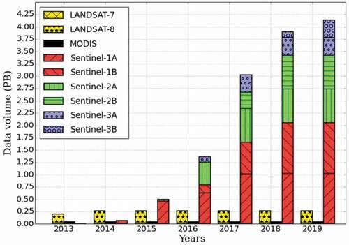
EO plays a crucial and increasingly important role in global environmental monitoring, as satellite constellations carrying EO sensors have been evolving at high pace during the recent decades. To name just two of them, the Landsat series of NASA’s Earth Observation system (NEOFootnote12) has a continuous history of almost five decades, while the Sentinel satellite missions of the European Copernicus programmeFootnote13 have reached an impressive level of maturity and completeness since 2015 (). As a consequence, EO data became globally available and can service the provision of a multitude of environmental indicators ranging from ocean salinity, to land cover dynamics and air quality. Additionally, free and open data policy became the norm in public EO programmes, from the design phase on. This fact, complemented by the evolution of data distribution and processing infrastructures, has led to a significant boom in EO data usage and penetration in different sectors.
Figure 13. EO data volume trends of selected relevant US and European satellite missions from Sudmanns, Lang, and Tiede (Citation2018)
Obviously, the need for global monitoring of a number of environmental indicators has always been a major driving force behind the design and construction of such systems. Hence, the capabilities they enable certainly include monitoring of several SDG indicator groups, carrying the heritage of multi-decadal environmental monitoring programmes, regrouped in a new logical frame.
The European Space Agency has recently published the “Compendium of EO contributions to the SDG Targets and Indicators”, compiled by the ESA-funded EO for SDGs project, in close cooperation with the GEO EO4SDG initiative and the CEOS Ad-Hoc Team on SDGs (ESA, Citation2021). This work synthesizes a large number of previous research and review publications and provides a complete overview on the current situation, possibilities and perspectives of EO in topics related to SDG indicators.
In the present paper, we have selected the domains and indicators with clear links to EO techniques, and concentrated on those directly relevant to Hungary. The status and perspectives of each of these selected indicators are presented below from a Hungarian viewpoint, based on ESA (Citation2021). Indicators we considered relevant are grouped under the corresponding SDGs.
Goal 1. End poverty in all its forms everywhere
Indicator 1.5.2 Direct economic loss attributed to disasters in relation to global gross domestic product (GDP)
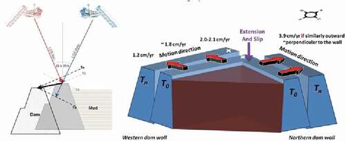
EO can play an important role in damage assessment to infrastructure and productive land uses. For example, SAR interferometry can be applied for the continuous monitoring of features such as dams, reservoirs or buildings (see on the red mud reservoir disaster). One module of the Hungarian Earth Observation Information System (FIR), developed for the Disaster Management authority, is responsible for the continuous Interferometric Synthetic Aperture Radar (IFSAR)-based monitoring of the movements of more than 50 water facilities in Hungary.
Figure 14. Simple three-dimensional illustration of the observed displacements showing the motion and the consequent deformation of the structure at a red mud reservoir in Kolontár, Hungary, by using Permanent Scatterer (PS) interferometry. From Grenerczy and Wegmüller (Citation2013)
Goal 2. End hunger, achieve food security and improved nutrition and promote sustainable agriculture
Indicator 2.3.1 Volume of production per labour unit by classes of farming/pastoral/forestry enterprise size
Although the indicators for these goals are not yet finalised, it can already be stated that EO may support the computation of some of the parameters required to calculate the indicator, complemented with ancillary data from the National Statistics Office. Prediction of biomass production and yield in such production systems is within the scope of EO for over two decades with promising results, especially when combined with modelling, further catalysed by the availability of more frequent and multimodal observations.
Indicator 2.4.1 Proportion of agricultural area under productive and sustainable agriculture
Although household surveys can provide these data, EO has a supporting and controlling role to provide a more global and standardised approach. Environmental parameters that affect larger areas and parameters that cannot be assessed by individual farmers should be in focus here. Long-term processes observed on agricultural land, the appropriate handling and the status of ecological focus areas can also be important EO contributions.
Goal 3. Ensure healthy lives and promote well-being for all at all ages
Indicator 3.9.1 Mortality rate attributed to household and ambient air pollution
Air quality is an important issue in Hungary, causing thousands of premature deaths every year (European Commission, Citation2018). Combining in-situ sensor data, satellite measurements (e.g. Sentinel-5P) and spatially explicit mortality data can provide excellent possibilities for risk assessment and planning of mitigation.
Goal 6. ensure availability and sustainable management of water and sanitation for all
Indicator 6.4.1 Change in water-use efficiency over time
Water management is certainly a crucial issue in Hungary. Extreme water conditions already cause important damage to crops and menace ecosystems, and with climate change ongoing, these events are expected to become increasingly frequent. Often, the same areas are affected by excess water conditions in one period and drought in other periods of the year, sometimes just weeks apart. Moreover, apart from precipitations, most of the surface waters available in the country originate from abroad. Hence, it is of utmost importance to manage water resources in a wise, efficient and sustainable way. EO techniques can support estimations of water use efficiency in agriculture in terms of yield gained per unit of water added. Nevertheless, this also requires the availability of reliable ancillary data and is ideally complemented with analytical and/or artificial intelligence (AI)-based modelling.
Indicator 6.6.1 Change in the extent of water-related ecosystems over time
Sub-indicator 1: spatial extent dynamics
A variety of EO methods enable efficient mapping and monitoring water bodies and surrounding land covers. However, monitoring of vegetated wetland areas such as swamps or water-affected grasslands is still a challenging task, although numerous analytical techniques are being developed. As some of these areas are critical biodiversity hotspots, research interest in these areas should be encouraged. They are already within the scope of Hungarian ecosystem mapping and monitoring developments (Tanács et al., Citation2019). By combining use of EO, in-situ and ancillary geospatial datasets, efficient solutions can be found.
Sub-indicator 2: water quality (lakes/artificial water bodies)
Several indices related to the quality of surface water, especially lakes, can be monitored by EO methods at different spatial resolutions and with different accuracies. Hungarian water authorities are already involved in the governmental EO information system (FIR), but with water quality currently being out of the scope. However, there are initiatives to enlarge the portfolio and to elaborate solutions for operational use of EO techniques for water quality as well.
Sub-indicator 3: water quantity
Water quantity is harder to estimate by EO techniques. However, when combined with hydrological modelling and/or ancillary geospatial data, it can still provide promising results. For example, volumes of inland excess water are estimated in the FIR system by the combined use EO-based detection of inundated areas and digital elevation models.
Goal 11. Make cities and human settlements inclusive, safe, resilient and sustainable
Indicator 11.3.1 Ratio of land consumption rate to population growth rate
EO has been used to monitor urban growth since the 60s. Over European territory, the CORINE and subsequent Copernicus Land Monitoring programmes of the European Union play an important role here, providing detailed data in a consistent time series since 1990. Moreover, Copernicus high-resolution layer (HRL) “Imperviousness” (https://land.copernicus.eu/pan-european/high-resolution-layers/imperviousness) can be directly used for this purpose. Additionally, a new national high-resolution layer (nHRL), still under development, is also available for several years with more detailed content (see ).
Figure 15. Subset from the National High Resolution Land Cover (nHRL) under preparation, provided by R. Pataki. From Kristóf et al. (Citation2019)
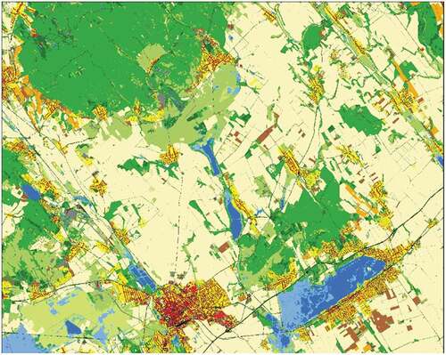
Indicator 11.5.2 Direct economic loss in relation to global GDP, damage to critical infrastructure and number of disruptions to basic services, attributed to disasters
Damage to critical infrastructure and disruption to services can be directly mapped from EO while GDP impact can only be inferred from such visible damage. As mentioned above, the FIR system already has a continuous monitoring module focusing on critical infrastructure, based on corner reflectors and IFSAR methods.
Indicator 11.6.2 Annual mean levels of fine particulate matter (e.g. PM2.5 and PM10) in cities
In Hungary, excess levels of fine particulate matter are unfortunately a serious problem, leading to important effects on human health and the environment, with heating and traffic being the two main sources (European Commission, Citation2018). EO-based methods, e.g. those utilizing Sentinel-5P data for fine particulate matter detection over cities are routine and operational, and can provide timely information over a large extent. They can be used in combination with in-situ measurements from locally deployed air quality sensor networks.
Indicator 11.7.1 Average share of the built-up area of cities that is open space for public use for all, by sex, age and persons with disabilities
EO techniques can easily map open and green spaces within urban areas. However, socioeconomic variables associated with this indicator have to be mapped from independent sources. For example, the Ecosystem Map of Hungary (http://alapterkep.termeszetem.hu/) also integrates some land use and cadastral information for the delineation of such areas and is available as a separate thematic layer. However, combination with other socio-economic factors requires further development.
Goal 15. Protect, restore and promote sustainable use of terrestrial ecosystems, sustainably manage forests, combat desertification, and halt and reverse land degradation and halt biodiversity loss
Indicator 15.1.1 Forest area as a proportion of total land area
Detection of forested areas can be done in a very reliable way from EO. Moreover, status, interventions and damages can also be assessed by using both well-established and newly developed methods. The combination of EO-based products with local reference data can produce reliable change estimates. The FIR system also contains a module for forest monitoring, developed along the specific needs of national forest authorities. The EU-led CORINE and Copernicus Land Monitoring programmes also have pan-European forest-specific high-resolution layers.Footnote14 Additionally, forest inventories and management systems have been digitised and are available over the whole national territory. Issues, however, might arise from different classifications of forested vs. non-forested areas and woodlands among different sectors and disciplines, which require mindful harmonisation of categories and careful integration of data sets.
Sub-indicator a: forest area net change rate
EO techniques are widely and successfully used to map forest cover and its changes, a number of methods exist at different levels of technical complexity and reliability. Copernicus HRL and change layers are available Europe-wide, and the forest monitoring module of FIR also provides relevant thematic output. Besides this, digital forest inventories and spatial data bases related to forest management can yield valuable information. Nevertheless, here again, a clear and easily interpretable definition of categories is a must, especially when it comes to EO-based detection and monitoring.
Sub-indicator b: above-ground biomass stock in forest
Biomass estimation is a mature topic in forest management, but most often based on in-situ measurements. In the last decade, airborne laser scanning and sometimes airborne SAR are also increasingly applied for this purpose. Though EO methodologies exist for estimating biomass and detecting its changes, e.g. SAR tomography, the technology is not fully mature and requires a high level of expertise.
Indicator 15.3.1 Proportion of land that is degraded over total land area, with three sub-indicators capturing trends in land cover, land productivity, and carbon stocks.
Sub-indicator on trends in land cover
EO fully supports calculation of this indicator. Already, the Copernicus Land Monitoring ServiceFootnote15 is providing a multitude of crucial data sets in a consistent time series, including CORINE legacy data and additional high-resolution layers. Moreover, the European Environment Agency is currently elaborating an enhanced system to provide even more detailed and consistent data, mostly based on EO methods. As for national initiatives, the production of a time series of a national high-resolution layer (nHRL), integrating both EO and in-situ data, is ongoing (Kristóf et al., Citation2019). The National Ecosystem Map () is an important contribution as well, related strongly to land cover.Footnote16 FIR system also has promising capabilities in this respect. Altogether, calculation of this indicator has a solid basis both on national and pan-European level.
Figure 16. Ecosystem Map of Hungary.Footnote19 The underlying data set was integrated from a variety of EO and non-EO data sources with a resolution of 20 m over the whole national territory. It will serve as a basis for change detection and monitoring as well as for the assessment of ecosystem services
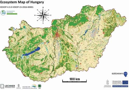
Sub-indicator on trends in land productivity
There is sufficient evidence to suggest that EO could fully support countries in the production of this indicator as land productivity proxies are routinely monitored. However, this also requires the availability of reliable reference data as well as appropriate models. Quantification of ecosystem services also includes elements strongly linked to land productivity. Hence, these activities are interrelated with mapping and assessment of ecosystem services (MAES).Footnote17
Sub-indicator on trends in carbon stocks, above and below ground
Estimation of carbon stocks and monitoring of carbon fluxes have been investigated for multiple decades now. Flux measurements are most often done by recurring to flux towers, such as those involved in FLUXNET.Footnote18 Hungary has multiple sites registered here, with representative towers installed over different vegetative covers. Up-scaling of measurements is often done by applying EO data sets. Carbon stock estimations are regularly done in the frame of national reports to UN bodies. However, challenges remain to trend detection as comparability between different time periods is limited by changes in EO and lack of robust time series.
7. Critical assessment and present SDG status of Hungary
7.1. A case on rating the Hungarian SDG status
Based on a 2019 European SD Report (SDSN & IEEP, Citation2019) and an interdisciplinary overview (KSH, Citation2019) the SDG status of Hungary for the 2018–2019 period examined isn’t excellent. Hungary SDG Performance Index scores 65.1 (21th from the EU 28), and the position is the last third of the EU member countries. shows challenges remaining for 3 goals of SDGs (see yellow), and significant challenges remaining for 13 goals of SDGs (see brown).
Figure 17. SDG Dashboard – 2019 assessment of Hungary (SDSN & IEEP, Citation2019)
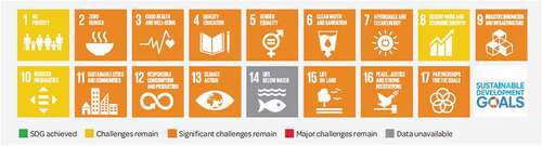
describes the SDGs Hungarian trends. One of the first EU SDG priorities is the “Green Deal”, the Hungarian greening policy supporting the SDGs 2, 6, 7, 12, 13 and 15.
Figure 18. SDG 2019 Trends – Hungary (SDSN & IEEP, Citation2019)
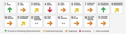
In Hungary the EO technology is the credible framework tool for registering and continuously monitoring the SDGs, land use, infrastructure, pollution, climate change, biodiversity, natural resources, etc., covering almost every important SDG phenomenon. The Covid19 pandemics drastically transformed our world and the everyday way of life. It is a chance to enforce “New normality” after the pandemics, to introduce strong technologies to support the SDGs. Success here requires strong lobby activities to weight efforts in certain sectors in establishing sustainable development transformation for Hungary.
7.2. Hungarian status of GI and EO related operations for SDGs
The WG4SDG volunteers studied the reports on the Hungarian status of SDGs published by the Hungarian Central Statistical Office (in 2007, 2012, 2014, 2016, 2018), the National Committee on SD (in 2013, 2014, 2015–2016 and 2017–2018) and the Voluntary National Review of Hungary on SDGs of the 2030 Agenda presented at the High-level Political Forum (HLPF) of UN (Report Hu, Citation2018). The special standpoint was to examine the stakeholder’s view on using the GI and EO data for monitoring and reporting purposes in SDGs implementation procedure. A position paper has been published in the Hungarian journal Geodézia és Kartográfia summarizing the status of GI/EO utilization for SDGs in our country (Mihály & Remetey-Fülöpp, Citation2020).
As critical assessment on the present status of GI and EO data utilization in Hungary, some evidence-based conclusions of the position paper are as follows:
the GI and EO capacity and expertise are adequate in Hungary, their professionalism makes them capable to support the SDG-policy for wide range of applications,
the different Hungarian spatial data themes are controlled by professionals recognized worldwide,
each section of the spatial data themes is functioning fully comprehensive, internally determined and institutionalized with full country-coverage and
administration of each spatial data theme has been acting for a long time based on their fully arranged policy acts, regulations and rules.
The above listed capabilities don’t facilitate effectively the implementation of SDGs in every case.
Use of spatial data in the implementation procedure politically is not declared by any act. There are deficiencies as follows:
the separately well-functioning spatial data themes are connected only sporadically with common standard interface,
the interoperability between the spatial data theme is not satisfactory,
the data sharing and service policy for them is chaotic and not organic neither in-between relation nor with respect to the national economy,
the separately well-functioning spatial data themes are not connected comprehensively in a spatial data infrastructure,
the common and integrated use of spatial data themes with the statistical data is missing, and
there is incompleteness in legal act acts and rules and technical standards promoting the unification content, format and share of data as well as their fiscal correlative homology.
The incompleteness above is to be recovered for successful and economical implementation of the goals of sustainable development as it is conceived in Chapter 8.
8. Tasks to be accomplished in the future
MFTTT has suggestions based on its experience in awareness-raising actions and status assessment in Hungary. They are aligned with international practices and fully oriented for the interest of successful and economical implementation of the goals of the UN 2030 Agenda and the National Framework Strategy on SD. The professional civil society MFTTT envisages the following tasks to be accomplished in the near future:
MFTTT WG4SDG working in continuous cooperation with the Hungarian governmental institutions, forums and professional societies functioning for sustainability;
promoting a policy in Hungary that declare the GI and EO data and services as the proper and unavoidable tool for transparent, credible and documented monitoring and reporting on implementation of numerous goals of SD;
promoting a policy that defines operation of the national GI/EO data as integrated with the statistical data for implementation of SDGs and other purposes;
promoting the establishment of NSDI which is the only way to provide the interoperability between the data and organizations and which is basic requirement to introduce and operate big data systems of new era;
advancing international relations, in addition to the involvement in ESA-driven EO programs, projects and actions, keeps the already established working links with the EO information systems and services community of CEOS WGISS with important purpose to strengthen the capabilities of FIR and FOK serving the SDG-related tasks;
continuing and deepening the partnership with task force of the GEO’s initiative “EO for SDGs” (EO4SDG) with the aim to share best practices from research and development to applications and from capacity building to exploitation of novel applicable tools to meet the requirements of the big data era; and,
advocating the presence and involvement of the Hungarian academic, innovation and research communities in the work of the ISDE to ensure interdisciplinary collaboration using capable, interoperable infrastructures based on promising technologies and relevant capacity building.
A major task will require forging of links with policy influencers and decision-makers in order to facilitate interagency collaboration, data sharing and integration of GI/EO data with national statistics. The goal is an NSDI as a common platform for spatiotemporal analysis and reporting of phenomena changing in space and time.
9. Conclusions
It can be stated that EO can provide valuable contributions for the calculation of a significant number of SDG indicators. Though often useful in itself, real breakthrough can be achieved in cases where EO techniques are combined with ancillary, in-situ data sets of good quality. For complex indicators, this is essential; for simpler analyses, EO methods can still be corroborated by the inclusion of non-EO data and methods in the analysis. Certainly, availability, abundance and quality of ancillary (non-EO) spatial data sources such as registries, administrative and management data or sensor network measurements have a strong influence on viable results. A well-established spatial data infrastructure (SDI) can catalyse this by providing standardised ways for the discovery and efficient use of relevant spatial data sets. An extremely efficient assessment and monitoring system could be obtained by combining this with the current and projected capabilities of FIR, the Hungarian Earth Observation Information System.
Accomplishing institutionalization of the SDG-related of EO/GI tools and capabilities in the near future is essential, combined with the integrated use of EO/GI data and capabilities with statistical data, and the establishment of national spatial information infrastructure, as well as the development and spreading of the SDG-related use of big data.
We must emphasize the importance of getting over the limits of narrowly conceived professional acts. A driving force for our profession must be the continuous cooperation with the Hungarian governmental and international institutions, forums and professional societies working together for sustainability as well as with the SDG stakeholders interested in using the spatiotemporal resources. These resources are effective and the key elements that will guarantee our EO/GI capability to answer the requirements of fundamental sustainability for Humankind and the Nation. Hungary must promote the ongoing development of sustainability, as it has been formulated in the UN 2030 Agenda and the Hungarian National Framework Strategy on Sustainable Development.
Acknowledgments
The authors gratefully thank Patrick Hogan, NASA Earth Scientist Emeritus for the kind assistance he provided in language editing.
Disclosure Statement
No potential conflict of interest was reported by the author(s).
Additional information
Notes on contributors

Szabolcs Mihály
Szabolcs Mihály
Academic experience: Dipl. Surveyor (Institute of Geodesy, Aerial Surveying and Cartography, Moscow, 1967), Doctor Tech. (Technical University of Budapest, 1982), Candidate of Sciences (Hungarian Academy of Sciences, HAS, 1981). Practical experience: Satellite geodetic techniques and GPS; Elaboration and harmonisation of Hungarian “Digital Base Map” standard; Coordination of national and international R+D projects of GIS. Last positions: Director General, Institute of Geodesy, Cartography and Remote Sensing, Hungary (FÖMI, 1997-2010); Delegate to INSPIRE of EC (2011-2012). Membership: Hungarian Society of Surveying, Mapping and Remote Sensing, MFTTT (President 2007-2011, Vice-president 2011-2015); Geodetic and Geoinformation Scientific Committee, HAS (1985-); Chair of the Hungarian GI Standardization (1995-2012); HUNAGI member; EuroGeographics and FIG Comm. 3 Representative. Recent volunteer position: Leader, WG4SDG Working Group for Sustainable Development at MFTTT. As corresponding author for this article, he is co-editor together with G. Remetey-Fülöpp. He is author of Chapters 1, 2, 5.1 and co-author of Chapters 5, 7, 8 and 9.

Gábor Remetey-Fülöpp
Gábor Remetey-Fülöpp
Academic experience: Dipl. Civil Eng. (1968), Dipl. Automation in Geodesy (1981), Doctor Tech. (1985), all at the Technical University of Budapest. Practical experience: Satellite Image Processing; coordination in Remote Sensing/GI/LIS; Domestic networking in GI; International co-operations in GI/LIS/SDI/EO/Digital Earth and SDGs. Last positions: Chief Counselor (Ministry of Agriculture and Rural Development, FVM, 1986-2007); Secretary-general, (Hungarian Association for Geoinformation, HUNAGI, 1994-2015). Delegated to GEO and CEOS WGISS by GSDI (2006-2018), President, ISPRS Commission VII (1996-2000), Membership: earlier in Subcommittees of HAS on Photogrammetry /Geoinformation; HUNAGI; Executive Committees of UNECE WPLA, EUROGI and ISDE; Board of Directors of GSDI; recently: Hungarian Society of Surveying, Mapping and Remote Sensing WG4SDG; HUNAGI, ISDE, Council of Space Research of MFAT, Delegate in GEO EO4SDG by MFTTT. He is co-editor together with Sz. Mihály. He is author of Chapter 3 and co-author of Chapters 7, 8 and 9.

Dániel Kristóf
Dániel Kristóf
Dániel Kristóf, Ph.D., is the head of Earth Observation Department at Lechner Knowledge Centre, Budapest, Hungary (legal successor of the Institute of Geodesy, Cartography and Remote Sensing - FÖMI). Additionally, he is Hungarian delegate to the Earth Observation Programme Board of the European Space Agency (ESA), mandated by the Ministry of Foreign Affairs and Trade. Previously, he worked as Head of FÖMI’s Geoinformation Department (2010 to 2016) and Geoinformation Group Leader at BFKH-FTFF (2017). Graduated MSc in Environmental Management from Szent István University (Hungary) in 2000, obtained a joint PhD degree in Environmental Science / Remote Sensing from Université Paul Sabatier/CESBIO (France) and Szent István University (Hungary) in 2005. Assistant professor at the Dept. of Geomatics of Szent Istvan University from 2004 to 2007. His research topics include time-series analysis of optical remote sensing data along with the integration and classification of heterogeneous geospatial data sets. He is author of Chapter 6.2.

Anna Czinkóczky
Anna Czinkóczky
Associate professor of MATE.
Academic experience: MSc. in Mathematics and Physics (ELTE Budapest, 1983), Ohio State University, Columbus, OH (USA) Master of Arts in Mathematics, PhD in Informatics (2003, ELTE Budapest). Last positions: Head of Department of Laboratory of Spatial Analysis and Environment at MATE University Hungary. Membership: Hungarian Fuzzy Association, John von Neumann Computer Society, Hungarian Academy of Sciences, Member of Academic board. She is author of Chapter 4.5.
Tamás Palya
Tamás Palya
Graduated Master in Civil Engineering, specialised for Geodesy and GIS in Technical University of Budapest, 1997. Graduated in Civil Engineering, specialised GPS navigation in Technical University of Budapest, 2001. He is currently at Lechner Nonprofit Ltd (formerly was Institute of Geodesy, Cartography and Remote Sensing). He has experiences in numerous national and international R+D projects. He is member of Hungarian INSPIRE expert team. He is Vice-chair of QKEN (Quality Knowledge Expert Network) at EuroGeographics. He is member of WG4SDG at MFTTT. He is author of Chapter 5.2.
László Pásztor
László Pásztor
He has a DSc degree.
He is Director of the Institute for Soil Sciences, Centre for Agricultural Research and Head of Department of Soil Mapping and Environmental Informatics of his Institute. He has more than 25 years of experience in digital soil mapping, spatial soil information systems, spatial environmental modelling and proximal soil sensing. He participated, and in certain cases coordinated the institutional role in national and international research programs and led also numerous national research projects. Most recently, he has been coordinating the Digital, Optimized Soil Related Maps and Information (DOSoReMI) initiative for the renewal of the Hungarian soil spatial data infrastructure. He is author of Chapter 5.3.

Pál Rudan
Pál Rudan
Academic experience: Teacher (Pázmány Péter Catholic University Faculty of Humanities and Social Sciences, 2000), Ph.D. pre-degree certificate in Regional Researches (Pázmány Péter Catholic University Doctoral Faculty of Humanities and Social Sciences School of History, 2006), Postgraduate specialist training in applied geospatial information technology (Budapest University of Technology and Economics, Faculty of Civil Engineering, 2008). Practical experience: Coordination and implementation of various electronic support and process management systems R+D projects, Technical coordination of „Hungarian National Spatial Data infrastructure” project, Technical coordination of „Hungarian Earth Observation System” project. Last positions: Director at Lechner Knowledge Center Nonprofit Company (2009-2015), Technical project leader at „Hungarian National Spatial Data infrastructure” project at Institute of Geodesy, Cartography and Remote Sensing (2015-2017), Technical project leader at „Hungarian Earth Observation System” project at Govemmental Agency for IT Development (2017-). He is author of Chapter 6.1.
György Szabó
György Szabó
Associate Professor at the Department of Photogrammetry and Geoinformatics, Budapest University of Technology and Economics. He graduated in Civil Engineering and received PhD in Geoscience from the Budapest University of Technology and Economics. Beyond his academic work he has more than 30 years’ experience in applied research and development of national and international projects. He is the secretary general of the Hungarian Association for Geoformation (HUNAGI), an active member of the Hungarian Society of Surveying and Mapping, president of GIS commission and the John von Neumann Computer Society. He is author of Chapter 4.4 and 7.1.

László Zentai
László Zentai
Institute of Cartography and Geoinformatics, ELTE Eötvös Loránd University, Budapest.
Academic experience: Master in Cartography (1984), Doctor univ. (1992), PhD degree (1995), Doctor of Science, (Hungarian Academy of Sciences, 2006). Practical experience: Computer cartography, digital atlases, topographic maps, relief representation, topographic and orienteering maps, education and training in cartography. Publications: Over 200 scientific papers, more than 100 maps and atlases. Membership: Former Secratary-General of the International Cartographic Association (2011–2019). Recent positions: Vice President of the ICA (2019–), Vice-Rector of ELTE Eötvös Loránd University (2007–2010; 2017–), Council member of the International Orienteering Federation (2006–), Director of the Institute of Cartography and Geoinformatics (2005–). He is author of Chapters 4.1, 4.2, and 4.3.
Notes
8. https://mbfsz.gov.hu/ and English: https://www.linkedin.com/company/mbfsz/
10. The NAGIS web site link: https://nater.mbfsz.gov.hu/en/node/169 and https://map.mbfsz.gov.hu/nater
References
- Albrecht, F., Blaschke, T., Lang, S., Abdulmuttalib, H., Szabó, G., Barsi, Á., Batini C., Bartsch A., Kugler, Zs., Tiede, D., Huang, G. (2018). Providing Data Quality Information for Remote Sensing Applications. International Archives of Photogrammetry and Remote Sensing, 42(2002), 15–22. . 3.
- Annoni, A., Goodchild, M. F., & Guo, H., Eds.. (2019). Manual of Digital Earth. Sringer. https://doi.org/10.1007/978-981-32-9915-3 in eBook: https://link.springer.com/book/10.1007/978-981-32-9915-3 [Accessed: 28.05.2021
- Arrouays, D., Grundy, M. G., Hartemink, A. E., Hempel, J. W., Heuvelink, G. B. M., Hong, S. Y., … Zhang, G.-L. (2014). GlobalSoilMap: Towards a fine-resolution global grid of soil properties. Advances in Agronomy, 125, 93–134.
- Barsi, Á., Kugler, Z., Juhász, A., Szabó, G., Batini, C., Abdulmuttalib, H., Huang, G., Shen, H. (2019). Remote Sensing Data Quality Model: From data sources to lifecycle phases. International Journal of Image and Data Fusion, 1–30.
- Batini, C., Blaschke, T., Lang, S., Albrecht, F., Abdulmuttalib, H., Barsi, Á., Szabó, G., Kugler, Zs. (2017). Data Quality in Remote Sensing. The International Archives of the Photogrammetry, Remote Sensing and Spatial Information Sciences, Volume XLII-2/W7, 2017ISPRS Geospatial Week 2017, 18–22 September 2017, Wuhan, China.
- CAS, 2020. Big Earth Data in support of the Sustainable Development Goals Big Earth Data Program. Chinese Academy of Science, September2020. pp.1-133.
- Craglia, M., Hradec, J., Nativi, S., & Santoro, M. (2017). Exploring the depths of the global earth observation system of systems. Big Earth Data, 1(1–2), 21–46.
- Csornai, G., Bognár, E., Mikus, G., Wirnhardt, C., & Mihály, S. (2009): Maintenance and Development of the Maintenance and Development of the Hungarian Land Parcel Identification Hungarian Land Parcel Identification. FIG Working Week 2009, Eilat, Israel, [ Accessed: 28.05.2021] https://www.fig.net/resources/proceedings/fig_proceedings/fig2009/ppt/ts05b/ts05b_csornai_etal_ppt_3443.pdf
- ELTE TGI, (2021) WG4SDG document library. http://lazarus.elte.hu/wg4sdg/[ Accessed: 28.05.2021]
- ESA (2018). Satellite Earth Observations in support of the Sustainable Development Goals. http://www.eohandbook.com/sdg [ Accessed: 28.05.2021]
- ESA (2021). Compendium of EO contributions to the SDG Targets and Indicators. [ Online]: https://eo4society.esa.int/wp-content/uploads/2021/01/EO_Compendium-for-SDGs.pdf [ Accessed: 28. 05.2021]
- European Commission (2018). Air quality: Commission takes action to protect citizens from air pollution [Online]: https://ec.europa.eu/commission/presscorner/detail/en/IP_18_3450. [ Accessed: 28.05.2021]
- FFT.BFKH Portal (2018). Portal of the Department of Geodesy, Remote Sensing and Land Offices, under the Government Office of the Capital City Budapest, http://www.ftf.bfkh.gov.hu/portal_en/index.php/organization [ Accessed: 28.05.2021]
- Grenerczy, G., & Wegmüller, U. (2013). Deformation analysis of a burst red mud reservoir using combined descending and ascending pass ENVISAT ASAR data. Natural Hazards, 65(3), 2205–2214.
- Guo, H. (2014). Digital Earth: Big Earth Data. Editorial International Journal of Digital Earth, 7(1), 1–2.
- Guo H., Goodchild M.F., Annoni A. (eds).(2020). Manual of Digital Earth. Springer, Singapore.. https://doi.org/10.1007/978-981-32-9915-3_1 Accessed: 28.05.2021
- Guo, H., Liu, Z., Jiang, H., Wang, C., Liu, J., & Liang, D. (2017). Big earth data: A new challenge and opportunity for digital earth’s development. International Journal of Digital Earth, 10(1), 1–12.
- Hernandez, M. (2018): Digital Earth in Support of the UN Sustainable Development Goals. Handout of the Interdisciplinary Conference on Geoinformation and Sustainable Development. Bonn, 24-28 July, 2018. p 30.
- ICA. (2020). Mapping for a Sustainable World. Kraak M.J., Roth, R.E., Ricker, B., Kagawa, A. & Le Sourd, G. 2020. New York, NY (USA): The United Nations.
- IISD SDG (2016). Sustainable Development Goal 17 Partnership for the goals. Retrieved from https://sdg.iisd.org/sdgs/goal-17-partnerships-for-the-goals/[ Accessed: 28.05.2021]
- Kavvada, A. (2018). EO4SDG: Earth Observations in Service of the 2030 Agenda for Sustainable Development. In: ESA (2018). Satellite Earth Observations in support of the Sustainable Development Goals. http://www.eohandbook.com/sdg [Accessed: 20.05.2021]
- Kavvada, A. (2021). The Earth Observations Toolkit for Sustainable Cities and Human Settlements: Overview and progress to date https://eo-toolkit-guo-un-habitat.opendata.arcgis.com/datasets/eo-toolkit-overview-document-02-2021 [ Accessed: 24. 05.2021]
- Keesstra, S. D., Bouma, K. J., Wallinga, J., Tittonell, P., Smith, P., Cerdà, A., … Fresco, L. O. (2016). The significance of soils and soil science towards realization of the United Nations Sustainable Development Goals. SOIL, 2(2), 111–128.
- Kovács, K. (2017). Space Activity at BME. Budapest: MANT.
- Kristóf, D., Petrik, O., Pataki, R., Lehoczki, R., Belényesi, M., Friedl, Z., … Mikus, G. (2019): Combined use of EO imagery and in situ data for country-wide land cover mapping and monitoring for various applications in Hungary: Status and perspectives. Proceedings of the ESA Living Planet Symposium, Milan, Italy, May 13–17, 2019
- KSH. (2019). Indicators of the Sustainable Development Goals in Hungary. 2018. (Written in Hungarian: A fenntartható fejlődés indikátorai Magyarországon, 2018). Budapest: Author. 2019. http://www.ksh.hu/docs/hun/xftp/idoszaki/fenntartfejl/fenntartfejl18.pdf [Accessed: 28.05.2021], information https://www.ksh.hu/?lang=en
- LandGIHU (2018). Official Portal of the Hungarian Land and Geoinformation Administration, http://www.foldhivatal.hu/ or in English: http://en.foldhivatal.hu/ [ Accessed 28.05.2021]
- McBratney, A., Field, D. J., & Koch, A. (2014). The dimensions of soil security. Geoderma, 213, 203–213. Accessed: 28.05.2021
- McBratney, A. B., Mendonça Santos, M. L., & Minasny, B. (2003). On digital soil mapping. Geoderma, Vol. 117, 3–52. https://doi.org/https://doi.org/10.1016/S0016-7061(03)00223-4. ISBN 6129351321
- MFTTT (2021), WG4SDG document library. https://www.mfttt.hu/mftttportal/index.php/mfttt-wg4sdg/a-munkacsoport-anyagai [ Accessed: 28. 05.2021].
- Mihály, S., Palya, T., & Remetey-Fülöpp, G. (2018). Geospatial data for the SDGs (In Hungarian, with extended abstract in English). Geodézia És Kartográfia, 70(3), 13–23. 2018/3 .
- Mihály, S., & Remetey-Fülöpp, G. (2020). Geospatial and Earth Observation infrastructure for the Sustainable Development- An Executive Summary (In Hungarian). Geodézia És Kartográfia, 72, 25–27. 2020/3.
- Mihály, S., Remetey-Fülöpp, G., & Palya, T. (2017). Awareness raising on EO/GI/SDI for SDGS – The case of Hungary. International Scientific Journal: Micro Macro & Mezzo Geo Information, 2017, 7–25. MMM-GI No.9-2017 December
- NAGIS (2018), Official Portal for National Adaptation Geo-information System. https://nater.mbfsz.gov.hu/en/node/161 [ Accessed: 28.05.2021]
- Pásztor, L., Laborczi, A., Takács, K., Szatmári, G., Fodor, N., Illés, G., … Szabó, J. (2017). Chapter 9 - Compilation of Functional Soil Maps for the Support of Spatial Planning and Land Management in Hungary. In P. Pereira, E. C. Brevik, M. Muñoz-Rojas, & B. A. Miller (Eds.), Soil Mapping and Process Modeling for Sustainable Land Use Management (pp. 293–317). Atlanta (GA): Elsevier.
- Pásztor, L., Laborczi, A., Takács, K., Szatmári, G., Bakacsi, Z., Szabó, J., & Illés, G. (2018). DOSoReMI as the national implementation of GlobalSoilMap for the territory of Hungary. In D. Arrouays, I. Savin, J. Leenaars, & A. B. Mcbratney. (Eds..), GlobalSoilMap - Digital Soil Mapping from Country to Globe (Vol. 2018, pp. 6). London: CRC Press. Paper .
- Pásztor, L. (2021). Advanced GIS and RS Applications for Soil and Land Degradation Assessment and Mapping. ISPRS International Journal of Geo-Information, 10(3), 128.
- Rahman, M., & Szabó, G. (2020). National Spatial Data Infrastructure (NSDI) of Bangladesh – Development, Progress and Way Forward, ISPRS Annals of the Photogrammetry. Remote Sensing and Spatial Information Sciences, V-4-2020, 131–138, https://doi.org/https://doi.org/10.5194/isprs-annals-V-4-2020-131-2020,2020.
- Remetey-Fülöpp, G. (2017). The Challenge of Raising Stakeholder Awareness at All Levels. GIM International, 31(9), 6.
- Remetey-Fülöpp, G. (2020). Response to the Challenges: The First Two Decades of a National Gi Association (1994-2015). International Scientific Journal “Micro, Macro & Mezzo Geo Information, 2020. 15, 81–101. UDC: 061:528(439)”1994/2015”
- Remetey-Fülöpp, G., Horvai, F., Zboray, Z., Mihály, S., Palya, T., Zentai, L., … Farkas, P. (2019a): HSO Liaison Report includes update on MFTTT WG4SDG with EO industry and ground segment activities. CEOS WGISS-47 Plenary hosted by NOAA, Silver Spring, April 29 – May 2, 2019. http://ceos.org/document_management/Working_Groups/WGISS/Meetings/WGISS-47/4.%20Thursday%20May%202/2019.05.02_14.40_HSOv2.pptx [ Accessed: 31.05.2021]
- Remetey-Fülöpp, G., Kristóf, D., Mihály, S., Palya, T., Zentai, L., Iván, G., … Zboray, Z. (2018): Hungarian Space Office Liaison Report includes update on MFTTT WG4SDG with EO research and apps activities. CEOS WGISS-46 Plenary hosted by DLR, Oberpfaffenhofen, 22-25 October 2018 https://ceos.org/document_management/Working_Groups/WGISS/Meetings/WGISS-46/1.%20Monday/2018.10.22_17.00_HSOReportv2.pdf [ Accessed: 28.05.2021]
- Remetey-Fülöpp, G., Mihály, S., Palya, T., Zentai, L., Hargitai, P., & Iván, G. (2019b): Unlock and Use EO/Geospatial Data for SDGs by Empowering Stakeholder Engagement in a Transformed Society. In IOP Conference Series: Earth and Environmental Science, Volume 509, 11th International Symposium on Digital Earth (ISDE 11) 24-27 September 2019, Florence, Italy. ( Eds.Nativi, S., Wang, C., Landgraf, G., Liberti, M.A., Mazzetti, P. & Mohamed-Ghouse, Z.S.)
- Remetey-Fülöpp, G., Mihály, S., Palya, T., Zentai, L., Hargitai, P., & Iván, G. (2019c): Promoting the use of EO/GI data and support the related ecosystem development for SDGs DLR Symposium on New Perspectives of Earth Observations. Cologne, 12-13 November 2019. https://www.dialogplattform-erdbeobachtung.de/downloads/cms/Stele8/EO-Symposium_Gabor.Remetey.pdf [ Accessed: 28.05.2021]
- Report Hu (2018): Voluntary National Review of Hungary on the Sustainable Development Goals of the 2030 Agenda. Transformation towards sustainable and resilient societies 2018. Ministry of Foreign Affairs and Trade of Hungary. https://sustainabledevelopment.un.org/content/documents/20137Voluntary_National_Review_of_Hungary_v2.pdf [ Accessed: 28.05.2021]
- RFG Napló (2015-2021): An Earth observation and Geoinformation web diary. https://hunagi8.blogspot.com [ Accessed: 28.05.2021]
- Sanchez, P. A., Ahamed, S., Carré, F., Hartemink, A. E., Hempel, J., Huising, J., … Zhang, G. L. (2009). Digital soil map of the world. Science, 325(5941), 680–681.
- Scott, G. (2017) Disaggregation by geographic location: The geostatistical dimension of the SDGs. 10th Annual Conference European Forum for Geography and Statistics. 2-3 November, 2017 Dublin.
- Scott, G., & Rajabifard, A. (2017). Sustainable development and geospatial information: A strategic framework for integrating a global policy agenda into national geospatial capabilities. Geo-spatial Information Science, 20(2), 59–76.
- SDSN & IEEP. (2019). The 2019 Europe Sustainable Development Report. Sustainable Development Solutions Network and Institute for European Environmental Policy: Paris and Brussels.
- Sudmanns, M., Lang, S., & Tiede, D. (2018). Big Earth Data: From Data to Information. GI_Forum, 1, 184–193. https://doi.org/10.1553/giscience2018_01_s184.
- Szatmári, G., Pirkó, B., Koós, S., Laborczi, A., Bakacsi, Z., Szabó, J., & Pásztor, L. (2019). Spatio-temporal assessment of topsoil organic carbon stock change in Hungary. Soil and Tillage Research, 195, 104410. Accessed: 28.05.2021
- Tanács, E., Belényesi, M., Lehoczki, R., Pataki, R., Petrik, O., Standovár, T., Varga, I. (2019). Országos, nagyfelbontású ökoszisztéma- alaptérkép: Módszertan, validáció és felhasználási lehetőségek. (Country-wide high-resolution ecosystem base map: Methodology, validation and usage possibilities.). Természetvédelmi Közlemények, 25, 34–58. 1216-4585
- Tóth, G., Hermann, T., Da Silva, M. R., & Montanarella, L. (2018). Monitoring soil for sustainable development and land degradation neutrality. Environmental Monitoring and Assessment, 190(2), 57.
- United Nations (2015). A global geodetic reference frame for sustainable development. Resolution adopted by the General Assembly on 26 February 2015. UN General Assembly Sixty-ninth session Agenda item 9 A/RES/69/266 UN
- UNSD (2021): The SDG Geospatial Roadmap. https://unstats.un.org/unsd/statcom/52nd-session/side-events/25Feb-The-SDGs-Geospatial-Roadmap-v2.pdf [ Accessed: 28. 05.2021].
- Yigini, Y., Olmedo, G. F., Reiter, S., Baritz, R., Viatkin, K., & Vargas, R. (2018). Soil Organic Carbon Mapping Cookbook (2nd edition ed.).FAO, Rome, Italy.
- Zentai, L., Iván, G., Mihály, S., Palya, T., & Remetey-Fülöpp, G. (2020): Land Administration as a Key Element in SDG’s Success ICA 7th International Conference on Cartography and GIS, Nessebar.
- Zentai, L., Mihály, S., Remetey-Fülöpp, G., & Palya, T. (2018): Geospatial Data and Services to Support the UN Agenda 2030 Implementation: Hungarian Activities. In Proceedings, 7th International Conference on Cartography and GIS, Vol. 1 and Vol. 2 June 2018 Publisher: Bulgarian Cartographic Association. ( Eds.Bandrova, T. & Konečný, M.) ISBN: 1314-0604.Sozopol, Bulgaria.