
ABSTRACT
Leaders are increasingly calling for improved decision support to manage human and environmental challenges in the 21st Century. The 17 United Nations Sustainable Development Goals (SDGs) provide a framing of these challenges, wherein 169 targets require significant data to be monitored and pursued effectively. However, many targets are still not connected with big Earth data capabilities. In this conceptual paper, the authors sought to answer the question “How are partnerships influencing progress in using big Earth data to address the SDGs?” Using the Pivotal Principles for Digital Earth, we reflect on the geospatial sector’s partnering efforts and opportunities for enhancing the use of big Earth data. We use Australia as a case study to explore partnering for action towards one or more SDGs. We conclude that partnerships are emerging for big Earth data use in addressing the SDGs, but much can still be done to harness the power of partnerships for transformative SDG outcomes. We propose four key enabling priorities: 1) multiple-stakeholder collaboration, 2) regular enactment of the problem-solving cycle, 3) transparent and reliable georeferenced data, and 4) development and preservation of trust. Five “next steps” are outlined for Australia, which can also benefit practitioners and leaders globally in problem-solving for the SDGs.
1. Introduction
The United Nations (UN) sustainable development goals (SDGs) require targeted local action, at-scale, around the globe (Metternicht, Mueller, & Lucas, Citation2020). As concluded by Anna Wellenstein (Director of Land and Spatial, World Bank), “High-quality, timely geospatial information is often overlooked in policymaking, yet is fundamental to achieving inclusive growth and sustainable development” (UN, Citation2018a). The geospatial community has long recognised the responsibility attached to this international stewardship agenda, with seminal papers by Dangermond (Citation2010), Goodchild (Citation2010) and Craglia et al. (Citation2012) providing clear calls to action for geospatial decision-support. Over the last decade, progress in technological advancements has continued to offer extraordinary levels of intelligence, to quantify, analyse and visualise information. Geospatially enabled data can tell us “what” and “where”, which is critical for environmental restoration and community resilience, location by location (Ehlers, Woodgate, Annoni, & Schade, Citation2014; Guo, Goodchild, et al., Citation2020).
The emergent availability of “big Earth data” – i.e. intelligence “at-scale”, provides new frontiers for geospatial information to provide decision-support (Guo et al., Citation2017; Weitz, Carlsen, Nilsson, & Skånberg, Citation2017). This “big Earth data disruption” includes very detailed local appreciation of current and future risks (Guo, Goodchild, et al., Citation2020; Guo, Chen, Sun, Liu, & Liang, Citation2021), and unprecedented opportunities for predicting and evaluating progress over space and time (UNGGIM and GEO, Citation2015; Xu et al., Citation2020). It also includes increasing national and international capacities for computing analytics and storage, visualisation and transmission of data, and remote data extraction and curation of data from a myriad of sources spanning satellites to on-ground and ocean sensors (Anderson, Ryan, Sonntag, Kavvada, & Friedl, Citation2017; Sudmanns et al., Citation2020).
It is timely that the “big Earth data disruption” is occurring at the commencement of the “Decade of Action to deliver the SDGs by 2030”, providing a rapidly expanding range of tools for analysis and decision-support (Guo et al., Citation2021). The suite of 17 SDGs and are complex, with a high degree of interdependencies between the 169 component targets and 231 unique indicators within the targets (UN, Citation2015; UN, Citation2020a). There is an extraordinary amount of data sitting within each of the SDGs that needs to be captured, curated and communicated, including further disaggregation at the level of the indicators, where the data is broken up in relation to factors, such as geography (for example, urban and rural), and elements, such as gender, age, and income groups (Rajabifard, Citation2019). The subsequent volume of data provides many logistical challenges for countries as they work to meet global reporting expectations on their progress, in addition to prioritisation challenges to understand where budgets and resources would be best spent (ICS, Citation2017).
Referring to such logistical and prioritisation challenges, there are urgent calls for partnerships to improve coordinated action for the SDGs (Nilsson, Griggs, & Visbeck, Citation2016; Weitz et al., Citation2017; UN, Citation2018b; UN, Citation2020b), where the term “partnerships” referred to spans any multi-organisational, informal and/or formal, financial and/or in-kind collaboration involving multiple stakeholders, to address sustainable development. More recently, this has included increasing dialogue about using big Earth data to compile improved SDG indicator information (El-Haddadeh, Osmani, Hindi, & Fadlalla, Citation2020; Hassani, Huang, MacFeely, & Entezarian, Citation2021; MacFeely, Citation2019) including taking advantage of big data derived from views from space (Andries, Morse, Murphy, Lynch, & Woolliams, Citation2019).
It is well understood that the SDGs require partnerships; indeed, this was well documented even before the Millennium Development Goals (UN-CSD, Citation2002; Wildridge et al., Citation2004). Within the geospatial sector, the big Earth data disruption has prompted reviews of SDG-related partnership characteristics, to optimise SDG actions and outcomes (GEO, Citation2017; WGIC, Citation2021a). This includes the role of public-private partnerships, and the importance of partnerships in addressing related issues such as artificial intelligence and machine learning (WGIC, Citation2021b). Considering this rapid transition in accuracy and scale of geospatial data, the authors of this paper asked the question “How are partnerships encouraging the use of big Earth data to address the SDGs?”
In the following sections, we present the conceptual paper methodology for exploring the topic, including an extant literature review and a focus on Australia’s engagement with partnerships as an example using expert contributions during a special-session panel session at an international geospatial conference. We then discuss priority action areas for enabling the use of big Earth data going forward. The five next steps proposed have immediate relevance for practitioners and leaders globally, in the global race to address the SDGs this decade.
2. Methodology
For this research, we adopted a qualitative conceptual research approach. The typology of this approach and its new knowledge contribution in a “conceptual research paper” is different from a discussion document, a position paper, or an empirical research paper. A methodological approach to a conceptual paper demands rigour in the framing of the question, and in the clear assimilation and combining of evidence from existing theory and concepts to develop new knowledge that consolidates and builds on existing research and theory (Hirschheim, Citation2008; Jaakkola, Citation2020).
In contrast to other forms of papers that collect, analyse and present new data, a conceptual paper delivers novel insights about existing knowledge, which may also lead to further research questions (Hirschheim, Citation2008; Murungi & Hirschheim, Citation2021). In this way, a conceptual paper promotes broadening of the scope of thinking about a particular problem, contributing new knowledge in the form of synthesised ideas and a new appreciation of the phenomenon (Jaakkola, Citation2020). In addressing “what’s new?”, a conceptual research methodology links work across disciplines and provides multi-level insights into the questions being addressed (Flick, Citation2018).
For this study, the authors undertook a robust process of reflective enquiry into “what’s new” regarding enablers for encouraging big Earth data to inform problem-solving for the SDGs. With reference to the second author’s previous publication on three “Pivotal Principles” for enabling Digital Earth outcomes (Desha, Foresman, Vancheswaran, Reeve, & Hayes, Citation2017), the principles were used as a conceptual framing for addressing the question. We used literature review and a panel-based focus group designed by the first two authors, engaging with experts in the field who were based in Australia and internationally and nationally connected into the geospatial community of practice.
2.1. Conceptual framing of the research
The first two authors of this paper began by defining the “focal phenomenon” (Jaakkola, Citation2020) of an increasing abundance of data alongside calls to urgently address the SDGs. We could observe excellent examples of big Earth data being successfully used around the world for problem-solving and for visualisations to support decision-making, as recently documented in the “Digital Earth Manual” (Guo, Goodchild, et al., Citation2020). We have witnessed and participated in regular calls for partnerships to address the SDGs at the UN and other global agency conferences such as ISDE12, Locate21 and the UN-GGIM 2021 Forum.
Inductively considering differing conceptualizations of this phenomenon, the first two authors were inspired by the Rhyme of the Ancient Mariner (Coleridge, Citation1909) – “Water, water, everywhere, nor any drop to drink” – which prompted the second author to construe a variation of the adage: “Data, data, everywhere, nor any byte to be readily utilised”. This conceptualisation helped us to consider the parallel between the abundance of seawater being unsatisfactory to a thirsty sailor, and the relative ocean of data being unsatisfactory to leaders in need of usable and useful data to address the SDGs. Within this context, the second author brought to the process of enquiry, two publications of direct influence.
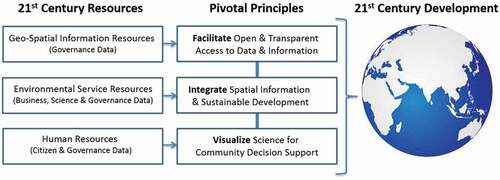
The first was a publication where Desha et al. (Citation2017) proposed that the confluence of technology and social disruptors presents a pivotal moment in history to engage in partnerships that “enable real-time, accelerated and integrated action that can adequately support a ‘future earth’ through transformational solutions”. With Digital Earth data emerging as a transformative opportunity, three pivotal principles are presented for successfully connecting geospatial data to decision-making for sustainable development and good governance: 1) access to open data; 2) grounding in real-world context; and 3) informed visualization for decision support (Desha et al., Citation2017). In this paper, the authors reflect on the availability of geospatial, environmental and human resources and the need to harness their potential for 21st Century development, as shown in .
Figure 1. Three principles for development in the 21st Century (Desha et al., Citation2017)
The second was a publication discussing the application of network theory; “The Chessboard and the Web” (Slaughter, Citation2017). Through an exploration of real-world situations and problem-solving, Slaughter concluded that many complex situations today demand looking not at the potential of individual entities but at the potential arising from their links to one another. Such an approach requires first learning to understand a networks’ composition and their shape, and then building on those connections to enable break-through outcomes.
Considering the complexities of the most recent technological leap within the Digital Earth agenda – i.e. to “big Earth data”, the Pivotal Principles were considered a useful frame of reference that could guide our progress enquiry into how big Earth data is being accessed, contextualised and visualised in problem-solving towards the SDGs. Network theory is also considered a useful context from which to approach mapping and identifying priorities for big Earth data to enable transformed SDG outcomes. We subsequently used this conceptual framing to ask, “How are partnerships influencing progress in using big Earth data to address the SDGs?”
2.2. Extant literature review
An extant literature review enables multi-level insights from the literature relating to expert contributions and other data sources (Flick, Citation2018). Our review of the literature focused on sense-checking the expert panellists’ lived experiences in working towards the SDGs within discourse on “partnerships for sustainable development”. Before and after the expert session we searched for the literature related to how partnerships are being used to enable big Earth data to be used for progressing the SDGs. The initial search focused on varying “AND” and “OR” compositions of the keywords “Digital Earth”, “big Earth data”, “SDG”, “example”, “case study*”, and “partnership*”.
Following the expert panel session, we also looked for additional literature discussing the role of multiple affiliations and connections in making use of geospatial information (big Earth data), and the important role of partnerships in ensuring long-term beneficial data use for decision-support. Subsequently, the full extent of the literature review comprised: 1) understanding the extent of partnerships related to big Earth data, in Australia and internationally; and 2) appreciating the value of partnerships in translating SDG challenges into problem statements that could be addressed with big Earth data.
2.3. Panel provocation with geospatial experts
Expert panel sessions are a valid social science research method that can support exploration of a topic, obtaining multiple perspectives in a sequence of planned contributions and subsequent discussions (Allen, Citation2017). With Australia being an historical leader in geospatial data curation and analytics (Mohamed-Ghouse et al., Citation2020), we envisaged that a panel-based review of Australia’s experiences in translating SDG challenges into geospatial problem-solving would provide a useful reference point for other countries’ multi-sectoral efforts in turning big data and geospatial knowledge into meaningful outcomes for sustainability.
We chose to use a conference expert-panel session to engage with experts from around Australia, who would already be engaging with the pre-eminent conference in the field, Locate21 (March 2021, Brisbane Australia). Using this logistical opportunity, we invited five distinguished panellists from the public and private sectors who were also internationally connected with the geospatial community of practice, to share how our geospatial-sector colleagues around Australia and internationally are engaging with data to support decision-makers in tackling unprecedented challenges and opportunities. Specifically, we sought perspectives on the following two questions:
How has Australia engaged with geospatial technology partnerships, that have improved the use of big Earth data towards the SDGs?
What opportunities or actions exist now for colleagues in your sector to work on building and enhancing existing partnerships for big Earth data to progress the SDGs?
Expert-panellists were invited drawing on the extensive network of the first author and through a network mapping exercise (through LinkedIn and online biographical details) to ensure breadth and depth of experience. Their invitation to participate was based on their substantive experience in the geospatial industry in Australia, and their current role as a senior leader within the private or public sector.
The process of curating the panel session included a one-hour interview by the second author with each panellist prior to the panel session to discuss the main research question and the key knowledge contributions that the panellist would contribute. It then comprised each panellist, creating a 5-minute vignette (summary) of the key points elicited during the pre-panel session interviews. During discussion time during the panel session, participants discussed and co-created several emergent themes, which were then followed-up after the session by email correspondence and online videoconferencing with the panellists and first author, regarding the transcripts and relevance to the research question.
The panel session was conducted live and online as part of the main-stage broadcast parallel session on 30 March 2021 (2.30–3.30pm). Participants posed questions in writing during the session, which were collated by the second author into questions for each speaker, and for a joint panel discussion at the end of the talks. The recording of the session provided a transcript for review and synthesis by the author team. The two panellists, who did not form part of the author's team, were invited to review the draft manuscript for accuracy, and to sense-check the discussions and conclusions. In the writing process all authors took on the role of individual member of the research team, without affiliation. As such, the manuscript reflects the knowledge synthesis of the individuals, drawing on knowledge already in the public domain via searchable websites and journal articles.
2.4. Author team declaration
The co-authors of this paper were prompted by the opportunity of the Locate21 conference (27–30 March 2021, Brisbane Australia), and the five-year anniversary of a previously published paper on using Digital Earth to enable problem-solving, to explore the role of partnerships in enabling big Earth data support problem-solving for the SDGs. In order to connect work across the spectrum of society, we were intentional about the team authorship of the paper, involving multiple sectors. Within this “whole of society approach”, we all took on the role of “citizen” as a dual role alongside our professional affiliation.
Subsequently, we declare multiple roles in the panel session that have been used for analysis. Furthermore, we declare roles within the panel session drawn on for this paper; one of the authors was the moderator, three authors were panellists, and the remaining two panellists provided review comments on the draft. Integrity in the process was addressed by accompanying the panel session with a literature review, and by cross-checking the methods and findings with the full expert panel from the conference panel.
3. Literature review: partnerships and big data for the SDGs
This section presents an exploration of the construct of “partnerships” for sustainable development, and “big Earth data” in the context of the SDGs to underpin our consideration of the research question, “How are partnerships influencing progress in using big Earth data to address the SDGs?” The following paragraphs then apply the discussion of theory to consider ways that partnerships could enhance the use of big Earth data to address the SDGs.
3.1. Partnerships for complex problem-solving
The discussion of the role of partnerships in complex problem-solving is connected to more than three decades of a practitioner and academic knowledge. In 1992, 178 countries began working towards the Millennium Development Goals (UN, Citation2005). In 2015, these commitments were revised through the 2030 Agenda for Sustainable Development (UN, Citation2015) to the United Nations (UN) Sustainable Development Goals (SDGs), with a mission to end poverty, protect the planet and improve the lives and prospects of everyone, everywhere.
According to the UN, a successful sustainable development agenda, “requires partnerships between governments, the private sector and civil society. These inclusive partnerships built upon principles and values, a shared vision, and shared goals that place people and the planet at the centre, are needed at the global, regional, national and local level” (UN, Citation2015). A significant measure of the extent of partnerships is the extent of local, regional and international relationships amongst the 192 countries around the world, in implementing a range of transformative initiatives and partnerships to deliver outcomes that foster sustainability globally. This spans governmental, organisational and individual network connections.
The UN Statistical Commission played a key role when the SDGs were developed. Through this work, a challenge was set for the global statistical and geospatial community, through the Expert Group for the Integration of Statistical and Geospatial Information, to: 1) address the critical importance of making location-enabled socio-economic data available; and 2) provide guidance on the integration of socio-economic data, which has been the domain of statisticians, with more traditional geospatial data that has traditionally been the focus of the geospatial community (UNGGIM, Citation2018).
The first challenge relates to how the data is provided to decision-makers who need to start developing or changing policy, introducing social or other changes to move other dimensions towards the global goals. The criticality of the second challenge is evident in some of the SDG indicators that rely on integration. For example, this could include the number of people with access to open space, access to public transport, access to all-weather roads, which have a real intersection between the geospatial and socio-economic dimensions.
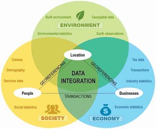
Location is often a common element in many data sets, which enables us to start to think about how we can bring the data sets together. This data integration problem is illustrated in , where location is often the common element, and point where data can be integrated, spanning statistical and administrative, as well as geospatial data sources from across a number of key information domains.
Figure 2. An illustration of the data integration problem facing decision-makers globally including location as the link between society, the economy and the environment. Source: Figure 1 in UN (Citation2019)
3.2. Connecting big Earth data with the SDGs
Within the context of “big Earth data”, progress towards the SDGs is increasingly about successfully translating “why” an SDG is important, into “what” data should be collected/curated and communicating “how” results can meaningfully assist the goal being achieved (ABS, Citation2014). Within the geospatial community, from individual practitioners through to industry and government leaders, there is an inherent appreciation of the value of geographically referenced (georeferenced) data across all of the 17 SDGs, yet connecting “where” into decision-support is still a work in progress in Australia (DFAT, Citation2018; Australian Government, Citation2018a and Citation2018b), and internationally (GPSSD, Citation2019).
COVID-19 heralded major disruption to the SDGs 2030 agenda, with significant derailment of many programs and the reporting on progress of these programs. During such times of turmoil, it is important to continue to track other indicators of resilience in the global capacity to deliver on the SDGs, to ensure that future capabilities are sustained or replenished (Allen et al., Citation2020). In the same year, the “2030 Agenda Partnership Accelerator” initiative published the SDG Partnership Guidebook (Stibbe & Prescott, Citation2020), to help accelerate and scale up effective partnerships in support of the UNSDGs. The guidebook asks the reader to consider the fundamental assumption that, “All of the ideas, people, technologies, institutions and resources that are required to achieve the SDGs are already available, and the task is how do we engage them and combine them in new and transformational ways.”
Working from this assumption, the geospatial community provides a valuable service to all sectors, in supporting the data collection, curation and communication of metrics associated with the SDGs. Common to the statistical and geospatial community is the location/visualisation requirements for data. The geospatial community also provides a mechanism for matching the necessary resources to meet the SDGs, assisting with global delivery of goods and services at the right-time and right-place, for the intended recipients. Towards this end, there is a significant need for the geospatial community to communicate the benefits of using geospatial data to monitor and manage progress towards the SDGs.
Situated as the last in the list of the SDGs, SDG-17 is an important enabler (ICS, Citation2017) with the goal to “Strengthen the means of implementation and revitalize the global partnership for sustainable development”. Nineteen targets provide direction on the types of partnerships deemed conducive to achieving sustainability, through engendering partnerships towards effective collaborative action. These span diverse topics including finance, technology, trade and multi-stakeholder partnerships.
Considering the list of SDG-17 targets with a “big Earth data” lens, eight targets (with their component 11 indicators) appear immediately relevant to needing the expertise of the geospatial community in practice to capture, curate and communicate such data. These are summarised in (full list provided in Attachment 1) including notes on examples of big Earth data contributions that are not yet visible on the UN website for the SDGs, building on the geospatial mapping previously undertaken by Anderson et al. (Citation2017). As shown in column 2, even for SDG-17 Partnerships – a critical enabling goal for the rest of the SDGS – for many indicators, a globally agreed methodology has not been set, and Australia has not yet investigated potential data sources.
Table 1. Targets within SDG-17 with potential geospatial contribution through the listed indicators. Source: Adapted from Anderson et al. (Citation2017) and the Australian Government (n.d.)
3.3. Geospatial Industry partnerships progress
Globally a concerted collaborative effort to define “big Earth data science” (Guo et al., Citation2021) alongside sustained advocacy for the role of EO data (Anderson et al., Citation2017; Andries et al., Citation2019; GEO, Citation2017) has helped to raise awareness of the importance of systematic collection, curation and use of geospatial information for the SDGs. In 2014, the report “A World that Counts” was produced for the UN Secretary-General’s independent Expert Advisory Group on a Data Revolution for Sustainable Development (Morales, Hsu, Poole, Rae, & Rutherford, Citation2014). The report recommended “quick wins” on SDG data to demonstrate capabilities in data collection, curation and communication. It included a call for an SDGs analysis and visualisation platform, and a dashboard on “the state of the world”. In 2017, when the UN Statistics Division convened the first UN “World Data Forum” geospatial information along with Earth Observation (EO) data became an informal theme for many of the sessions contemplating the SDGs.
Global partnership initiatives have been evolving to improve the use of big Earth data to address the SDGs. From the “GEOSS Evolve Initiative” (Nativi, Craglia, & DeLoatch, Citation2018; Nativi, Santoro, Giuliani, & Mazzetti, Citation2020) through to the UN’s Integrated Geospatial Information Framework (IGIF) (UN-GGIM, n.d.) and Global Statistical Geospatial Framework (GSGF) (UN, Citation2019), there has been significant progress in accessing and using geospatial information and knowledge (Guo, Nativi, et al., Citation2020), also highlighted in . A common thread through these initiatives is the presence of expansive collaborations and partnerships to address the complexity of the 169 targets and 232 indicators sitting within the 17 goals (Desha et al., Citation2017; Ehlers et al., Citation2014).
Table 2. Partnership examples for enabling big Earth data for the SDGs (2002–2021)
4. Expert panel session findings
In the following sections, we explore the partnership typology of Australia’s geospatial engagement with big Earth data towards the SDGs. We then present the current context and future partnership engagement opportunities presented by the panel experts, towards increasing the contribution of big Earth data.
4.1. Descriptive summary of panel networks
To ensure sufficient breadth and depth of the panellists to be invited, the first two authors undertook a desk-based network mapping exercise, based on LinkedIn profiles and curriculum vitae details of each panellist. We also undertook a pairing search to see whether listed professional organisations and UN entities were actively engaged with each other (i.e. through co-hosting conferences, projects and publications). These were mapped, together with the profiles of the two moderators, which comprise the full author-team for this paper.
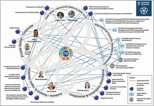
The resultant Partnership Network Model is presented in , which makes use of the venn-diagram structure of the SDG-17 5-petal icon. The diagram documents more than 35 formal geospatially related organisational links between panellists and organisations, visualising the depth and breadth of partnerships integrated within the Australian geospatial sector, across the five domains of: 1) Public Sector (Government spanning National, State and Local); 2) International councils, societies and networks; 3) Professional institutions and associations; 4) Academia – Research and higher education; and 5) the Private Sector (Corporate). These domains all fall within the broader context of “civil society”, of which all panellists are a part. Linkages connecting to civil society groups were not mapped for this project, as the method was limited to information already in the public domain.
On first impressions, the panellists were all Australian citizens, working in Australia. Several characteristics of the Partnership Network Model were subsequently of interest to the author team, in helping to appreciate the partnership typology:
The presence of a number of United Nations entities with multiple links to the panellists.
The strength of geospatial professional organisations.
The multiple affiliations of individuals beyond their core affiliation (i.e. place of employment).
Figure 3. A Partnership Network Model – Australian geospatial community (SDG-17), using the author-team biographic links as examples
4.2. Australia’s experiences in partnerships for big Earth data in support of the SDGs
Within the context presented earlier in this paper, it is widely accepted that Australia is a global leader in capturing, curating and communicating geospatial information to inform the UNSDGs (Mohamed et al., Citation2020). In the following paragraphs, the five storylines of the panellists are synthesised into the narrative of Australia’s partnerships and use of big data towards the SDGs.
4.2.1. Academic context: big Earth data leadership and capacity building
From a higher education provider perspective, Australian academic institutions have been active in enabling wider practice and uptake of big Earth data. This spans measuring, monitoring and comparing, to accurately track performance, and accelerate the journey towards sustainability as summarised in .
Figure 4. A schematic of the higher education sector’s contribution towards informed decision-making for the SDGs
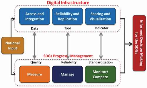
Such endeavours require national input throughout the sub-jurisdictions (state and local levels) to address the integrity of digital infrastructure components and the pragmatics of SDG measurements including data curation and visualisation. Software and hardware can be reasonably readily addressed, but human capabilities take longer.
As an example, at the University of Melbourne for the last two decades the research team has been working to support decision-makers on matters of sustainability importance. With stakeholders ranging from local through to state, national and international colleagues, researchers are passionate about clearly problem-solving in the entirety of the cycle, which is so important. This involves first listening for – then often translating the SDG challenges into geospatial problems, then – sometimes being very creative – working out what data – from space to geospatial – researchers can use and visualise to respond to the problem. Subsequently, embedding sustainability into core operations is the desired end goal, for researchers and for partners. An example of this collaboration is with the World Bank, where, through the “Sustainability and Resilience Project”, researchers created a process for a resilience and maturity index. Such projects are about translating the higher-order frameworks and goals into pragmatic processes for engaging with the SDGs, predicting and modelling success, and monitoring progress.
As a university, it is also very important to be proactive in building capacity for managing, monitoring and measuring sustainability progress across undergraduate and postgraduate curriculum of all types; from engineering through to law, planning, design, tourism and the arts. For example, at the University of Melbourne in 2020 1,200 projects were explored to consider how the SDGs could be better integrated into coursework, lesson by lesson and within assessment. Being able to map and visualise the results for senior leadership is crucial. It is also crucial for the students to be aware of the relevance of their education in this enlightened way. Graduates are then able to promote their expertise and value offer to employers within this context, which helps to shift the very systems we are seeking to support – across the public and private sectors.
4.2.2. International and national partnerships for big data integration
In Australia, the federal government already had a framework called the Statistical Spatial Framework (SSF), which led to Australia’s significant involvement in developing the global tool, known as the “Global Statistical Geospatial Framework”, or “GSGF”, shown in . The diagram informed the UN Statistical Commission’s work on a framework to guide globally consistent geospatial enablement data, and guidance on how to integrate data from the different domains.
Figure 5. Global Statistical Geospatial Framework (UN, Citation2019)
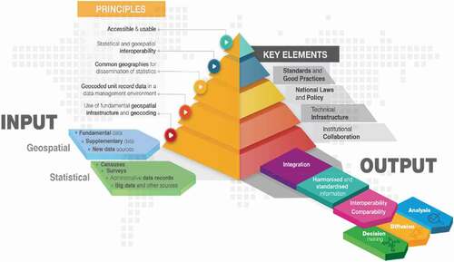
Through the application of the five principles and the supporting elements, the GSGF enables the production of harmonised and standardised geospatial information. The resulting data can then be integrated with a range of other statistical, geospatial and other information, to inform and facilitate data-led decision-making, including and particularly in the SDGs process. The framework has been endorsed by the UN and adopted by many countries and regions around the globe,including Europe, the Americas, and Africa. Subsequently, the Australian national government had both the SSF and the GSGF to ensure good location information available to support monitoring and managing the SDGs agendas around the country.
There are a few elements that we need to think about more in the future, particularly how we use contemporary data analysis and visualisation tools to put this information in the hands of decision-makers to make effective and sustainable decisions. One example is that the Australian Bureau of Statistics (ABS) is increasingly geospatially enabling its data and making the vast majority of it available as open data. Geosciences Australia is also working hard with the states and territories to make an increasingly wide array of geospatial data openly available to feed into this process.
4.2.3. Government perspective on partnerships for big Earth data: Victorian example
Spatial information and technology are providing new ways of thinking about where data could come from and how we can understand what is occurring at a systemic level. As we navigate new areas of thought and policy development, some of the emerging data gaps – and data coordination gaps – can be addressed through geospatial information systems providing intelligence about remote and complex environments, helping us measure what we are doing and achieving. The sense-making potential of the SDGs can be empowering for government. The Victorian context in Australia provides an interesting example of how government and legislative frameworks can enable geospatial data to make a difference, improving reporting and tracking progress on ecologically sustainable development.
There are aspects of the SDGs that are highly relevant to the Victorian Commissioner for Environmental Sustainability’s work. This comes primarily from the pre-prosecuted nature of the SDGs, a common and shared language and agreement internationally. Furthermore, the SDGs provide a framework to better understand what is happening, across systems and within the interconnections.
In Victoria, the Commissioner is appointed under the Commissioner for Environmental Sustainability Act 2003. The Commissioner provides independent advice and prepares a five-yearly State of the Environment report. These key reports include recommendations to the Government which are tabled in the Victorian Parliament and require a formal response. Such a context has enabled the Victorian government to develop actions over a number of years in relation to the SDGs.
In 2018 the Victorian State of the Environment (SoE) report aligned with the SDGs for the first time, reporting against 105 indicators within 52 selected SDG targets (Commissioner for Environmental Sustainability, Citation2018). The report broadly told three stories supported by geospatial data, about people, the built environment and the natural environment. It emphasised the role of science, data and community in decision-making, incorporating social science perspectives, and adopting the SDGs as an operating framework. The recommendations included the use of the SDGs as an organising framework and the importance of using international tools for reporting, as well as investing in spatial data and technologies. Applying the SDGs in this way has enabled the state to better address economic, environmental and social considerations. Using the SDGs as a framework for reporting has allowed additional depth of scientific story-telling, capable of reflecting the diverse views and complexities of the natural environment and the needs of Victorians.
The Framework for the Victorian State of the Environment 2023 Report (Commissioner for Environmental Sustainability, Citation2020) continues this work, committing to the use of geospatial data to explore the context for citizens, the built environment and the natural environment. Work is underway by the Commissioner to develop an understanding of the value for future investments in geospatial information, associated technologies and analytic techniques (including EO), in the statutory reports of this cycle. This includes working to understand current and future technologies, exploring what is on the horizon now and what is on the longer-term horizon, given the rapidly moving boundaries in what is possible and practicable for decision-support. This work will further enhance decision-making supporting ecologically sustainable development, and improve land, forest, marine and inland water management in Victoria.
4.2.4. Private sector corporate and professional perspectives on partnerships
In the private sector, the SDGs are enabling companies from small businesses through to corporations, to recognize that implementing SDGs can be part of their core business (GRI et al., Citation2015). For many companies in the geospatial industry, service work makes up the bulk of commercial work. Within this context, there is the opportunity to ask clients if they can be assisted to deliver on the SDGs, and therein to become an implementation partner. For Australian company Spatial Vision (where the first and fourth authors work), the journey to partner in big Earth data has been continuing over the last 5 years. Based on the range of tools available, the company initially used the SDG Compass (GRI, UNGC, WBSSD, Citation2015) that describes a series of implementation steps, from defining priorities, setting goals to reporting. One particularly interesting aspect was the Value Chain that helps clarify process impacts. Typically, the company responds to procurement requests from the customer, however, there have not yet been explicit procurement requests (tender documents) asking contractors to support clients to deliver on SDGs. The Victorian Government’s Social Procurement Framework is an example of specifying sustainability and social components that tenderers should include in their solutions. The sustainability components are linked to a standard that contributes to several SDGs.
From a professional perspective, Consulting Surveyors National represents approximately 500 businesses around Australia involved in geospatial practices. More than 70% of the membership employs less than 10 people, providing a “small-to-medium enterprise” focus that is experienced in many countries around the world. They are also located around the country in rural, remote and urban contexts, providing a very local voice to the discussion of progress towards the SDGs. Furthermore, the role of surveyors and geospatial professionals is embedded throughout many of the targets and indicators within the 17 SDGs, from flood and fire disaster recovery through to lease-hold arrangements for solar and wind farms, and future resilience through smart design and siting of our built environment and infrastructure assets.
The surveying practitioner community of practice in Australia are increasingly asking how big Earth data is being translated into actions that progress the SDGs. In 2020, the organisation sought to understand its impact on SDGs and the role that member businesses can play, from the work of surveyors in the bush marking up boundaries, to large-scale infrastructure projects. Based on this initial work, a sustainable development of a benchmarking tool is being considered for small-to-medium enterprise business owners and their stakeholders and a “declaration for a sustainable future” manifest for surveying firms is also being considered, taking the SDGs beyond data collection to day-to-day work.
5. Discussion: priorities for leaving no-one, and no-where, behind
The examples from the panel session clearly demonstrate the importance of the problem-solving cycle being enacted, comprising listening to the challenge, translating it into a geospatial problem, then engaging in the problem-solving. This multifaceted environment means that collaboration is essential, otherwise we will not achieve good return on investments of time and resources. This is a multi-institutional collaborative space that has room for all, from our local authorities through to the global United Nations. If we consider the priorities in the context of the Pivotal Principles introduced earlier in the paper – i.e. 1) open data, 2) real-world context and 3) informed visualization for decision support, then we also see clear opportunities for focusing on SDG-17 to foster multi-sectoral geospatial partnerships that can deliver the Digital Earth vision, across local, regional, and international communities and organizations, as discussed below.
5.1. Progress in enabling access to open data for SDGs
There has been significant progress in enabling an evidence-based approach to decision-making for all everywhere, ensuring that data is internationally enabled through agreements and partnerships, and locally contextualised – internationally (Maltais, Weitz, & Persson, Citation2018) and in Australia (Allen et al., Citation2020). However, there is still work to be done on the socio-economic dimensions being addressed in monitoring and reporting. This involves making the data available and enabling it at a location level. Perhaps, considering the GSGF for context and opportunity, the biggest role that the geospatial community can play across the public and private sectors, is to ensure that we have standard ways to geospatially enable our data including statistics, to make sure that the process of using the data is as easy as possible for decision-makers to integrate within their working knowledge of a given problem.
Looking forward in Australia, there are partnership opportunities to ensure that SDG-framed geospatial data is integrated into the delivered package of surveying work to a client. To embed the SDGs as a priority consideration in this process requires each of the five parts of the partnership model (the five petals of the partnership icon) to be engaged:
The public sector must provide a clear message through tender documentation and specifications that the SDGs and their component targets and indicators are important performance measures and drivers for project success.
International councils, societies and networks must provide clear guidance on how the SDGs can be actioned (i.e. through the UN Integrated Geospatial Information Framework (IGIF)) and provide examples of best practice and good practice, for all levels of government to feel confident in embedding SDG language and expectations within procurement and other tendering processes.
The private sector must use the IGIF and other available tools rather than recreating methods, and adopt an appropriate SDG-led sustainability themed proposal creation process.
Professional institutions and associations must ensure that there is a code of practice, charter or equivalent that requires members to uphold SDG-related priorities in their daily practice of their work.
Academia must generate and synthesise research evidence and tools, to support early thinking and conceptualisation of projects, for government directly, and for the private sector to use with government.
In Victoria, the social procurement framework requires contracts to respond to some social and environmental requirements. This could be expanded to support SDGs specifically and could also include an explicit request to contractors that they become an implementation partner if successful.
5.2. Progress in adapting to real world context
During the panel session, the expert panellists described a number of priorities for various parts of the geospatial community to address the SDGs. A common element of these contributions is the need for trust. Through sharing knowledge trust is built at an individual and organisational level. Through increased levels of trust, there are opportunities for better investment of time and resources to problem-solve, working with partners rather than reinventing solutions to problems, and avoiding the duplication of infrastructure investment (redundancy). Furthermore, with increasing disruptions due to climate change impacts (bushfires, cyclones, typhoons and flooding) and COVID-19 the most recent disruption around the world, work alignment between the three principles has become even more urgent over the last 5 years.
Within the UN SDG Report 2020 (UN, Citation2020a), the concluding chapter focused on the need for further data innovation, “in understanding, managing and mitigating the human, social and economic effects of the pandemic. They are also essential for designing short-term responses and accelerated actions to put countries back on track to achieve the SDGs”. In many parts of the world existing data challenges such as a lack of basic health, social and economic data limiting the success of COVID-19 response and recovery. Furthermore, routine data collection and curation is being impacted throughout the global statistical and data system due to the loss of individual personnel to the virus or ancillary services, emergency budget reallocations, and the general deprioritising of data collection such as counts and surveys for safety or other logistical reasons.
The Oceania region’s ability to report is summarised in , which likely reflects both the low COVID-19 exposure, and the benefits of a highly digitised system where geospatial and statistical information are linked.
Figure 6. Summary of global reporting progress on the SDGs during 2020, wherein Australia is part of “Oceania”. Source: UN (Citation2020a)
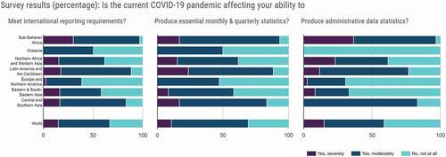
In this context, the discussion of Australian progress towards the SDGs comes at a time when the country – and Oceania region itself have for the most part avoided the extent of COVID-19 rates experienced elsewhere. The country is also benefiting from the development over the last two decades of a highly digitised system where geospatial and statistical information are linked (Mohamed Ghouse et al., Citation2020).
5.3. Progress in visualisation for decision-support
Standard information, decision support tools and visualisation tools are critical to demonstrating their value at a federal level. Using geospatial indicators to document environmental outcomes – while not mainstream yet is becoming increasingly possible to enhance reporting. The SDGs necessitate a broader thinking across economic, social and environmental, wherein geospatial visualisation of key indicators can help decision-makers appreciate the complexity of the systems in pragmatic supportive ways. For example, in Australia, the carriage of the SDGs process is managed by the Department of Foreign Affairs and Trade. There are a range of tools that Australia uses to track progress as a nation and to publish progress on the SDGs (DFAT, Citation2018).
The sense-making power of the SDGs appears to be empowering for government, to point to and reference in governance matters around policy and legislation. The complexity of the mechanics of the goals, indicators and measures can make them appear quite impenetrable at times. The Australian Government data agencies, such as the Australian Bureau of Statistics (ABS) and Geoscience Australia (GA), play a critical role in coordinating and curating data, and perhaps more importantly finding ways to get relevant data into the hands of decision-makers to support policy and other systemic changes in order to make progress on the SDG and sustainable development more broadly. From the overall coordinating, curating perspective, the role of GA is substantial, working through how data in such complex contexts can get into the hands of decision-makers to support policy and other systemic changes.
Notwithstanding the complexity, the goals provide a way for a common understanding of entire systems; indeed, this overarching simplicity speaks strongly to ways of working and ways of thinking. The key principles of the SDGs around partnerships, equity, information flow, technology and policy remain all the more salient as we navigate our current COVID-19 and other climate-related predicaments that we find ourselves in.
5.4. Next steps to enable the SDGs through big Earth data
The SDGs are very ambitious, requiring the enactment of duties by a symphony of government, academia, private sector, professional bodies and business associations, non-government organisations and the community playing together. In the journey to “good data leading to good outcomes for all”, data must be geospatially enabled to tell the stories, to convince actors at all levels to engage in SD, to understand where the gaps are, to take the right action, informed by evidence about “where”.
Within the geospatial community, there is a rapidly emerging and robust set of tools and technologies to present big Earth data in ways that engage with decision-makers – in conversation and in evidence-based problem-solving. The sector’s next steps must prioritise connecting these big Earth data “capture, curation, and communication” opportunities with decision-makers through partnerships:
Foster inter-governmental collaboration between statistics and geospatial departments and their experts: There have already been significant developments in this initiative both within Australia, and by Australian experts internationally. Some outcomes of this have been set in the recently launched Integrated Geospatial Information Framework (IGIF) and in the development of the Global Statistical Geospatial Framework (GSGF). Common to the statistical and geospatial community is the requirement to locate and visualise data. Such a partnership focused framework is transforming the ability of reporting agencies to monitor indicators within the 17 SDGs. This spirit of collaboration and the outputs from it need to become more visible in the business, academic and community sectors.
Enable partnerships to rapidly connect environmental and geospatial datasets for priority issues: There is a significant opportunity for geospatial contributions and decision support in environmental reporting. This includes tenders and bids that can include both geospatial and environmental sectors partnering to problem-solve – including, for example, monitoring the relevant SDG connected to land or the local environment.
Develop a charter for geospatial sector professionals: There is a timely opportunity for the geospatial sector to develop a charter on the impacts of SDGs on individuals and companies, promoting members’ enthusiasm for public good outcomes. Building on the SDG Align work, the charter elements would speak across professional disciplines. Through this charter, geospatial industry professionals spanning practitioners and decision makers could declare their commitment to addressing the SDGs within their daily work.
Promote best business practice: Promoting at project proposal, and project stage, the inclusion of SDGs discussions to consider partnerships required to ensure the best outcomes for the project and the SDGs. From a UNGGIM perspective it would be interesting to explore – and potentially map in a similar Partnership Network Model (), how the partnerships in IGIF have engaged with all geospatial communities (global, regional, national and local levels).
Benchmark performance, educate and monitor: Researching, building and disseminating tools that can be used by industry and government to monitor and improve on their use of the SDGs in the workplace. Tools to measure how firms are tracking could be merged into one “Monitoring SDG-17.7” tool to support benchmarking and measuring key performance indicators (KPIs), and monitoring progress.
6. Conclusions
In this paper, we have used a conceptual paper approach to explore the progress of partnerships in enabling big geospatial data to be used for meaningful problem-solving for the SDGs. We conclude that global progress in partnerships, encouraged by initiatives, such as the “Partnership Accelerator 2030 Agenda for Sustainable Development”, and the freely available “Digital Earth Manual” are connecting more organisations with the geospatial community, which is subsequently increasing the use of big Earth data to address the SDGs. As the public and private sectors address challenges of open data, data accessibility and data interoperability, big Earth data sets are being placed within the reach of smartphones and desktop devices around the world. This transformative shift is underway and accelerating, as discussed in the literature and by experts in the recent Locate21 Panel session. The COVID-19 pandemic in particular has transformed the use of maps by organisations and individuals to monitor things such as viral and variant spread, lockdown conditions, quarantine surveillance, and supplies of personal protective equipment and vaccines.
Australia’s experiences in connecting big Earth data to problem-solving for the SDGs are helpful to consider, regarding how the private and public sector have overcome such open data, accessibility and interoperability issues. The expert panel session provided an opportunity to learn from Australia’s context of innovating through partnerships, to enable open access to high-quality data prior to, during and after disasters.
Australia’s experiences are of potential use to others grappling with how to harness the potential of big Earth data to support decision-making for the SDGs. Using the lens of the Pivotal Principles, this includes four key enabling priorities:
Collaboration involving multiple stakeholders from a diverse cross-section, including individuals with multiple affiliations, to be able to quickly “join the dots” to data-use partnership opportunities.
Regular enactment of the problem-solving cycle and by many, to normalise the process of reaching for big Earth data as a “real-world context” knowledge source to inform decision-making.
Transparent and reliable ways to geospatially tag data, where the geospatial community can find ways to add “location” to existing data sets, significantly improve decision-support.
Development and preservation of trust by sharing open data, wherein multiple stakeholders across the public and private sectors can be assured of data integrity and equity in accessing information at the same time (for example, before, during and after disasters).
This complex task list for enabling big Earth data to support problem-solving requires multiple stakeholders and ongoing collaboration, which are the key ingredients of partnership. SDG-17 provides a reminder for all sectors to work in partnership towards achieving every target, and provides a clear to-do list for the geospatial sector in capturing, curating and communicating data to speak to at least eight of the 19 SDG-17 targets for progress in partnerships for sustainability. We have proposed a Partnerships Network Model to identify gaps and opportunities in connecting experts, leaders and practitioners, which could be used to augment “Tool 1: Stakeholder Mapping” within the SDG Partnership Guidebook.
It is intended that readers will use this paper to understand the opportunities for the geospatial sector to connect with existing partnerships for the SDGs, and to create new partnerships where the value of big Earth data in contributing towards problem-solving for one or more SDGs has not yet been realised. Big Earth data have a critical role to play – potentially in every SDG partnership – for ensuring that no-one, and nowhere, are left behind.
Attachment 1: SDG-17 - Revitalize the global partnership for sustainable development (Relevant items in blue) Source: https://www.refworld.org/docid/57b6e3e44.html
Finance
17.1 Strengthen domestic resource mobilization, including through international support to developing countries, to improve domestic capacity for tax and other revenue collection
17.2 Developed countries to implement fully their official development assistance commitments, including the commitment by many developed countries to achieve the target of 0.7% of ODA/GNI to developing countries and 0.15 to 0.20% of ODA/GNI to least developed countries ODA providers are encouraged to consider setting a target to provide at least 0.20% of ODA/GNI to least developed countries
17.3 Mobilize additional financial resources for developing countries from multiple sources
17.4 Assist developing countries in attaining long-term debt sustainability through coordinated policies aimed at fostering debt financing, debt relief and debt restructuring, as appropriate, and address the external debt of highly indebted poor countries to reduce debt distress
17.5 Adopt and implement investment promotion regimes for least developed countries
Technology
17.6 Enhance North-South, South-South and triangular regional and international cooperation on and access to science, technology and innovation and enhance knowledge sharing on mutually agreed terms, including through improved coordination among existing mechanismsin particular, at the United Nations level, and through a global technology facilitation mechanism
17.7 Promote the development, transfer, dissemination and diffusion of environmentally sound technologies to developing countries on favourable terms, including on concessional and preferential terms, as mutually agreed
17.8 Fully operationalize the technology bank and science, technology and innovation capacity-building mechanism for least developed countries by 2017, and enhance the use of enabling technology, in particular information and communication technology
Capacity building
17.9 Enhance international support for implementing effective and targeted capacity-building in developing countries to support national plans to implement all the sustainable development goals, including through North-South, South-South and triangular cooperation
Trade
17.10 Promote a universal, rules-based, open, non-discriminatory and equitable multilateral trading system under the World Trade Organization, including through the conclusion of negotiations under its Doha Development Agenda
17.11 Significantly increase the exports of developing countriesin particular, with a view to doubling the least developed countries’ share of global exports by 2020
17.12 Realize timely implementation of duty-free and quota-free market access on a lasting basis for all least developed countries, consistent with World Trade Organization decisions, including by ensuring that preferential rules of origin applicable to imports from least developed countries are transparent and simple, and contribute to facilitating market access
Systemic issues
Policy and institutional coherence
17.13 Enhance global macroeconomic stability, including through policy coordination and policy coherence
17.14 Enhance policy coherence for sustainable development
17.15 Respect each country’s policy space and leadership to establish and implement policies for poverty eradication and sustainable development
Multi-stakeholder partnerships
17.16 Enhance the global partnership for sustainable development, complemented by multi-stakeholder partnerships that mobilize and share knowledge, expertise, technology and financial resources, to support the achievement of the sustainable development goals in all countries, in particular-developing countries
17.17 Encourage and promote effective public, public-private, and civil society partnerships, building on the experience and resourcing strategies of partnerships
Data, monitoring and accountability
17.18 By 2020, enhance capacity-building support to developing countries, including for least-developed countries and small island developing States, to increase significantly the availability of high-quality, timely and reliable data disaggregated by income, gender, age, race, ethnicity, migratory status, disability, geographic location and other characteristics relevant in national contexts
17.19 By 2030, build on existing initiatives to develop measurements of progress on sustainable development that complement gross domestic product, and support statistical capacity-building in developing countries
Acknowledgments
The first two authors acknowledge the significant contribution to content by all panellists involved in the special session. Michael Reid and Martin Brady are acknowledged for their insights on the paper drafts, which helped the authors’ team in improving the paper's content. The authors’ team also acknowledge the World Geospatial Information Council, who have partnered with the International Society for Digital Earth through Barbara Ryan co-chairing the Working Group 2: Industry partnerships for Sustainable Development with the second author of this paper.
Data availability statement
This work has no associated data attached.
Disclosure statement
There is no financial interest or benefit that has arisen from direct applications of this research.
Additional information
Funding
Notes on contributors

Zaffar Sadiq Mohamed-Ghouse
Dr Zaffar Sadiq Mohamed-Ghouse is the Executive Director-Consulting at Spatial Vision, Australia. He is also the Vice President of International Society for Digital Earth and has leadership position at the United Nations Global Geospatial Information Management (UNGGIM) Network of Geospatial Societies and Private Sector. Zaffar has contributed to the development of United Nations Integrated Geospatial Information Framework and has implemented it at National and local level. He has been promoting UN SDGs amongst the Geospatial Community in Australia and Overseas. He has over 23+ years of experience in developing strategies for local-national-international government and private organisations, spatial data infrastructure, design, development and management of spatial databases and data models, review data framework policies, develop spatial analyses techniques and technology including GIS applications development for major clients in Australia, New Zealand, Malaysia, Saudi Arabia, United Arab Emirates, Indonesia and India.

Cheryl Desha
Associate Professor Cheryl Desha is the Theme Leader for the ‘Digital Earth and Resilient Infrastructure’ research agenda, Cities Research Institute (CRI) and Engagement Director (Industry) for the School of Engineering and Built Environment, Griffith University (Brisbane, Australia). Cheryl is a Chartered Member of Engineers Australia, and a member of the Surveying and Spatial Sciences Institute (SSSI). She is a Council member of the International Society of Digital Earth (ISDE) where she co-leads Working Group 2 ‘Industry Partnerships’. She is an Advisory Board member of the United Nations Global Geospatial Information Management (UN-GGIM), where she sits on the Disasters and Private Sector Network working groups.

Abbas Rajabifard
Professor Abbas Rajabifard is the Director of the Centre for Spatial Data Infrastructures and Land Administration (CSDILA) at the University of Melbourne. He is also the immediate-past Chair of the United Nations Global Geospatial Information Management (UN-GGIM). He has a strong track record in research and teaching, and academic leadership, and is internationally recognised scholar and engineer in Surveying and Mapping, Land Administration and Urban Systems.

Michelle Blicavs
Michelle Blicavs is the CEO, Association of Consulting Surveyors National. She brings her energy and passion to supporting member organisations and building relationships with stakeholders to ensure the voice of the surveying profession is heard, and the standards of the profession are upheld. She is also a member of the Surveying and Mapping Industry Council and is a Director of the Australian Construction Industry Forum as well as contributing to a number of other business and industry bodies representing surveying.

Graeme Martin
Graeme Martin is the General Manager Operations at Spatial Vision, helping government, utilities and emergency services solve complex challenges through geospatial solutions. With more than 20 years of experience in the private and public sectors, he has been part of the Spatial Vision journey since 2001.
References
- ABS. (2014). Measures of Australia’s progress, Issue 1370.0. Australian Bureau of Statistics. Retrieved from https://www.abs.gov.au/ausstats/[email protected]/mf/1370.0 .
- Allen, C., Reid, M., Thwaites, J., Glover, R., & Kestin, T. (2020). Assessing national progress and priorities for the Sustainable Development Goals (SDGs): Experience from Australia. Sustainability Science, 15(2), 521–538.
- Allen, M. (2017). ‘Panel presentations and discussions’, in The SAGE Encyclopedia of Communication Research Methods, Sage Research Methods, doi: https://doi.org/10.4135/9781483381411.n408 .
- Anderson, K., Ryan, B., Sonntag, W., Kavvada, A., & Friedl, L. (2017). Earth observation in service of the 2030 agenda for sustainable development. Geo-Spatial Information Science, 20(2), 77–96.
- Andries, A., Morse, S., Murphy, R., Lynch, J., & Woolliams, E. (2019). Seeing sustainability from space: Using earth observation data to populate the UN sustainable development goal indicators. Sustainability, 11(18), 5062.
- Australian Government. (2018a). ‘SDG-17 partnerships for the goals’ in Australian government’s reporting platform on the SDG Indicators. https://www.sdgdata.gov.au/goals/partnerships-for-the-goals .
- Australian Government. (2018b). Report on the implementation of the sustainable development goals: Report submitted to the high level political forum on sustainable development. Australian Government, Canberra, https://sustainabledevelopment.un.org/hlpf .
- Coleridge, S. (1909). The Rime of the ancient mariner (6th ed.). London: Robert Riviere & Son Ltd, Turabian.
- Commissioner for Environmental Sustainability. (2018). Victorian state of the environment 2018 report, commissioner for environmental sustainability, https://www.ces.vic.gov.au/reports/state-environment-2018 .
- Commissioner for Environmental Sustainability. (2020). Framework for the Victorian State of the environment 2023 report, Victoria State Government, https://www.ces.vic.gov.au/sites/default/files/CESV_Framework%20Report%202023_FINAL_WEB_OCT.pdf .
- Craglia, M., de Bie, K., Jackson, D., Pesaresi, M., Remetey-Fülöpp, G., Wang, C., … Woodgate, P. (2012). Digital Earth 2020: Towards the vision for the next decade. International Journal of Digital Earth, 5(1), 4–21.
- Dangermond, J. (2010). GeoDesign and GIS – Designing our Futures. In Buhmann, E. et al. (Eds.). In Peer Reviewed Proceedings of Digital Landscape Architecture. Germany: Anhalt University of Applied Science .
- Desha, C., Foresman, T., Vancheswaran, A., Reeve, A., & Hayes, J. (2017). Pivotal principles for Digital Earth development in the twenty-first century. International Journal of Digital Earth, 10(4), 371–385.
- DFAT. (2018). Australia’s report on the implementation of the sustainable development goals, Department of Foreign Affairs and Trade website, https://www.dfat.gov.au/aid/topics/development-issues/2030-agenda/Pages/sustainable-development-goals .
- Ehlers, M., Woodgate, P., Annoni, A., & Schade, S. (2014). Advancing digital earth: Beyond the next generation. International Journal of Digital Earth, 7(1), 3–16.
- El-Haddadeh, R., Osmani, M., Hindi, N., & Fadlalla, A. (2020). Value creation for realising the sustainable development goals: Fostering organisational adoption of big data analytics. Journal of Business Research. doi:https://doi.org/10.1016/j.jbusres.2020.10.066 .
- Flick, U. (2018). An introduction to qualitative research (6th ed.). London: Sage Publications.
- GEO. (2017). Earth observations in support of the 2030 agenda for sustainable development. Japan Aerospace Exploration Agency (JAXA) on behalf of the Group on Earth Observations under the EO4SDG Initiative, https://www.earthobservations.org/documents/publications/201703_geo_eo_for_2030_agenda.pdf.
- Geospatial World website. (2020). https://www.geospatialworld.net/ .
- Goodchild, M. (2010). Towards geodesign: Repurposing cartography and GIS? Cartographic Perspectives, (66), 7–22. doi:https://doi.org/10.14714/CP66.93 .
- GPSSD. (2019). Five-Year strategy 2019-2023, global partnership for sustainable development data. https://www.data4sdgs.org/sites/default/files/2019-01/GPSDD%20Five%20Year%20Strategy_0.pdf .
- GRI, UNGC, WBSSD. (2015). SDG compass, an initiative of the GRI, United Nations Global compact, and the World Business Council on Sustainable Development, www.sdgcompass.org.
- Guo, H., Chen, F., Sun, Z., Liu, J., & Liang, D. (2021). Big Earth data: A practice of sustainability science to achieve the Sustainable Development Goals. Science Bulletin, 66(11), 1050–1053.
- Guo, H., Goodchild, M., & Annoni, A. (Eds.). (2020). Manual of Digital Earth. Singapore: Springer. ISBN 978-981-329-915-3. doi:https://doi.org/10.1007/978-981-32-9915-3.
- Guo, H., Liu, Z., Jiang, H., Wang, C., Liu, J., & Liang, D. (2017). Big Earth data: A new challenge and opportunity for Digital Earth’s development. International Journal of Digital Earth, 10(1), 1–12.
- Guo, H., Nativi, S., Liang, D., Craglia, M., Wang, L., Schade, S., … Annoni, A. (2020). Big Earth data science: An information framework for a sustainable planet. International Journal of Digital Earth, 13(7), 743–767.
- Hassani, H., Huang, X., MacFeely, S., & Entezarian, M. R. (2021). Big Data and the United Nations Sustainable Development Goals (UN SDGs) at a Glance. Big Data and Cognitive Computing, 5(3), 28.
- Hirschheim, R. (2008). Some guidelines for the critical reviewing of conceptual papers. Journal of the Association for Information Systems, 9(8), 432–441.
- ICS. (2017). A guide to SDG Interactions: From science to implementation. Paris: International Council for Science. doi:https://doi.org/10.24948/2017.01.
- Jaakkola, E. (2020). Designing conceptual articles: Four approaches. Official Publication of the Academy of Marketing Science, Rev, 10, 18–26.
- MacFeely, S. (2019). The Big (data) Bang: Opportunities and Challenges for Compiling SDG Indicators. Global Policy, 10(1), 121–133.
- Maltais, A., Weitz, N., & Persson, Å. (2018). SDG-17: Partnerships for the Goals. A Review of Research Needs. Technical annex to the Formas report Forskning för Agenda 2030: Översikt av forskningsbehov och vägar framåt. Stockholm: Stockholm Environment Insitute.
- Metternicht, G., Mueller, N., & Lucas, R. (2020). Chapter 13: Digital Earth for Sustainable Development Goals. In H. Guo, M. Goodchild, & A. Annoni (Eds.), Manual of Digital Earth (pp.443–471). Singapore: Springer. ISBN 978-981-329-915-3. doi:https://doi.org/10.1007/978-981-32-9915-3_13.
- Mohamed Ghouse, Z., Desha, C., & Perez-Mora, L. (2020). Chapter 21: Digital Earth in Australia. In H. Guo, M. Goodchild, & A. Annoni (Eds.), Manual of Digital Earth. Singapore: Springer. doi:https://doi.org/10.1007/978-981-32-9915-3_21 .
- Morales, L. G., Hsu, Y., Poole, J., Rae, B., & Rutherford, I. (2014). A world that counts: Mobilizing the data revolution for sustainable development, Report to the United Nations Secretary-General by the Independent Expert Advisory Group on a Data Revolution for Sustainable Development. https://www.undatarevolution.org/wp-content/uploads/2014/12/A-World-That-Counts2.pdf .
- Murungi, D., & Hirschheim, R. (2021). Theory through argument: Applying argument mapping to facilitate theory building. European Journal of Information Systems, 1(26). doi:https://doi.org/10.1080/0960085X.2020.186952 .
- Nativi, S., Craglia, M., & DeLoatch, I. (2018). GEOSS evolve initiative. GEOS online document. http://ceos.org/document_management/Working_Groups/WGISS/Meetings/WGISS-46/3.%20Wednesday/2018.10.24_15.10_GEOSS%20Evolve-6.pdf .
- Nativi, S., Santoro, M., Giuliani, G., & Mazzetti, P. (2020). Towards a knowledge base to support global change policy goals. International Journal of Digital Earth, 13(2), 188–216.
- Nilsson, M., Griggs, D., & Visbeck, M. (2016). Comment - Policy: Map the interactions between Sustainable Development Goals. Nature, 534(7607), 320–322.
- Rajabifard, A. (Ed.). (2019). Sustainable development goals connectivity dilemma: Land and geospatial information for urban and rural resilience. Boca Raton: CRC Press, Taylor and Francis Group. ISBN 9780367259358.
- Slaughter, A.-M. (2017). The chessboard and the web: Strategies of connection in a networked world. New Haven, Connecticut: Yale Press.
- Stibbe, D., & Prescott, D. (2020). The SDG partnership guidebook, A practical guide to building high impact multi-stakeholder partnerships for the Sustainable Development Goals (first edition), A report by the United Nations Department of Economic and Social Affairs (UN DESA) and The Partnering Initiative (TPI), in collaboration with United Nations Office for Partnerships, UN Global Compact, and the UN Development Coordination Office .
- Sudmanns, M., Tiede, D., Lang, S., Bergstedt, H., Trost, G., Augustin, H., … Blaschke, T. (2020). Big Earth data: Disruptive changes in Earth observation data management and analysis? International Journal of Digital Earth, 13(7), 1–19.
- Tonchovska, R., Standley, V., & De Martino, S. (2012). Knowledge brief: Spatial data infrastructure and INSPIRE, Europe & Central Asia World Bank report, September 2012, Vol 55.
- UN. (2005). Millennium development goals report. New York: Author.
- UN. (2015). Transforming our world: The 2030 Agenda for Sustainable Development A/RES/70/1. https://www.refworld.org/docid/57b6e3e44.html .
- UN. (2018a). Experts launch roadmap to help countries develop, manage, and use vital geospatial data to address development challenges, News Item, Department of Economic and Social Affairs 1 August 2018, New York, https://www.un.org/development/desa/en/news/statistics/global-geospatial-information-management.html.
- UN. (2018b).The Sustainable Development Goals report 2018. United Nations, New York. https://unstats.un.org/sdgs/files/report/2018/TheSustainableDevelopmentGoalsReport2018-EN.pdf .
- UN. (2019). The Global Statistical Geospatial Framework (GSGF), Department of Economic and Social Affairs Statistical Division. https://unstats.un.org/unsd/statcom/51st-session/documents/The_GSGF-E.pdf .
- UN. (2020a) The Sustainable Development Goals Report 2020, Department of Economic and Social Affairs https://unstats.un.org/sdgs/report/2020/ .
- UN. (2020b). Decade of action: 10 years to transform our world. https://www.un.org/sustainabledevelopment/decade-of-action/
- UN-CSD. (2002). CSD guidelines for partnership for sustainable development. Johannesburg, South Africa: United Nations Publication.
- UNGGIM. (2018). Integrated Geospatial Information Framework (IGIF), United Nations Global Geospatial Information Management Integrated Geospatial https://ggim.un.org/igif .
- UNGGIM and GEO. (2015). Unleashing the Power of ‘Where’ to Make the World a Better Place: How Geographic Information Contributes to Achieving the Sustainable Development Goals. http://www.earthobservations.org/documents/meetings/20150422_geo_un_ny/20150422_geo_un_ny_flyer.pdf .
- UNGGIM Europe. (2019a). The integration of statistical and geospatial information — A call for political action in Europe, Eurostat, 12pp.
- UNGGIM Europe. (2019b). The territorial dimension in SDG indicators: Geospatial data analysis and its integration with statistical data, Instituto Nacional de Estatística, Lisboa.
- Weitz, N., Carlsen, H., Nilsson, M., & Skånberg, K. (2017). Towards systemic and contextual priority setting for implementing the 2030 Agenda. Sustainability Science, 13(2), 531–548.
- WGIC. (2021a). Report on public-private geospatial collaborations: Exploring potential partnership models, World Geospatial Industry Council Policy Report: 2021-02, an initiative of the 2030 Agenda Partnership Accelerator, ISBN 978-90-831569-1-0.
- WGIC. (2021b). Geospatial AI/ML (GeoAI) Applications and Policies – A Global Perspective, World Geospatial Industry Council study report: 2021-01, ISBN 978-90-831569-0-3.
- Wildridge, V., Childs, S., Cawthra, L., & Madge, B. (2004, June). How to create successful partnerships-a review of the literature. Health Information & Libraries Journal, 21(Suppl 1), 3–19. PMID: 15186286.
- Xu, Z., Chau, S. N., Chen, X., Zhang, J., Li, Y., Dietz, T., … Liu, J. (2020). Assessing progress towards sustainable development over space and time. Nature, 577(7788), 74–78.