Abstract
This letter explores key variables affecting radiance observed in the middle infrared (MIR) region (3−5 μm) over urban areas. To date, MIR has received little attention in urban remote sensing. Using Moderate Resolution Imaging Spectrometer (MODIS) band 23, which spans 4.02–4.08 μm, we examine (1) the seasonality of MIR, (2) the relationship between MIR radiance and percent impervious surface area (percentage ISA) and (3) sensor view zenith angle (VZA) effects on observed MIR radiance over cities. We find the effects of sensor VZA and percentage ISA to be two important factors influencing MIR radiance in urban areas, which allows settlements to emerge as islands of MIR brightness amidst MIR-dark vegetated landscapes.
1. Introduction
The middle infrared region (MIR) spans wavelengths from 3 to 5 μm on the electromagnetic spectrum, offering multiple atmospheric transmission windows (Boyd and Petitcolin Citation2004). MIR wavelengths are much longer than visible and near infrared light and thus can penetrate anthropogenic haze, smog and light smoke – a distinct advantage in urbanized areas (Kaufman and Remer Citation1994). However, little research has been conducted on the uses of MIR for terrestrial remote sensing (Henebry Citation2006). This dearth may be attributed to the hybrid nature of the MIR – a combination of solar reflection and thermal emission in the same order of magnitude for natural surfaces (Petitcolin and Vermote Citation2002). Principal sensors operating at MIR wavelengths include the NOAA Advanced Very High Resolution Radiometer (AVHRR) first launched in 1978, the Polar Operational Environmental Satellite (POES) series and the Moderate Resolution Imaging Spectrometer (MODIS) on the Aqua and Terra satellites (Boyd and Petitcolin Citation2004).
The MIR has been used for atmospheric remote sensing, such as cloud detection and classification (Cracknell Citation1997). Terrestrial remote sensing using the MIR – channel 3 (3.55–3.93 μm) on the AVHRR – has focused on hotspot detection, including volcano monitoring (Cracknell Citation1997, Cracknell and Boyd Citation2009) and fire detection (Cracknell Citation1997, Petitcolin and Vermote Citation2002). Other applications include detecting deforestation (Tucker et al. Citation1984), biomass burning (Roy Citation1999) and estimation of biophysical forest properties (Lucas et al. Citation2000). An early study investigated the MIR response over just three land-cover categories – forest, agriculture/grasslands and urban areas – noting a distinct urban/rural contrast (Kerber and Schutt Citation1986). MIR channels from AVHRR and MODIS were shown to have potential for sensing ‘dark, dense vegetation’, especially over areas plagued by ‘biomass burning smoke or industrial/urban haze’ (Kaufman and Remer Citation1994). Since the deployment of AVHRR/3 on-board NOAA-15 in 1998, the MIR channel (3B) has been restricted to night-time use for cloud mapping and sea surface temperature measurements (NOAA Citation2013).
The effects of seasonality on MIR radiance observations must be understood before analysing the potential uses of the region for urban remote sensing. Green vegetation is MIR-dark, reflecting less than 5% of insolation (Salisbury and D’Aria Citation1994). This property is caused by internal scattering and absorption of MIR wavelengths by water in plant tissue (Belward Citation1991), leading to low-radiance observations over green vegetation. In contrast, dried vegetation and soils are MIR-bright, reflecting up to one-third of the incident radiation and exhibiting high radiance (Henebry Citation2006). Open water, snow and most clouds also appear MIR-dark and exhibit lower radiance than green vegetation. Concretes, asphalts and other building and paving materials are MIR-grey, much brighter than green vegetation but darker than soils or dried vegetation (Henebry Citation2006). Building, roofing and paving materials comprise impervious surfaces, which are the man-made non-permeable surfaces that characterize urbanized areas (Weng 2008). The presence or absence of green vegetation, dried vegetation, bare soils and snow/ice at the same location are functions of time of year.
Accordingly, it is critical to understand how land surface seasonality affects MIR phenomenology before the potential of the MIR for urban remote sensing can be unlocked.
Directional influences on MIR reflectance have been found to be angle-dependent in AVHRR imagery (Petitcolin et al. Citation2002). We are interested in assessing directional influences in MODIS band 23, which has a longer wavelength (4.05 μm vs. 3.75 μm) but narrower bandwidth (60 nm vs. 380 nm) than AVHRR channel 3. Here, we focus on the influence of sensor view zenith angle (VZA). Since MODIS is a whiskbroom sensor, pixel size is enlarged along the edges of the swath, where sensor VZAs are high (0° < VZA < 64°) (Xiong et al. Citation2009). How does VZA affect the observed radiance? Are the effects predictable?
In the past, most urban area analysis used aerial photography taken in the visible wavelengths (Roberts and Herold Citation2004). Yet, radiometric correction procedures used to improve remote-sensing data at visible wavelengths have been found to be ill-suited for the removal of spatially varying air pollution in urban imagery (Rogan and Chen Citation2004). Most aerosols do not affect MIR radiation through scattering or absorption (Libonati et al. Citation2012). The urban/rural contrast exhibited at MIR wavelengths, combined with the ability to penetrate urban haze and smog, merits the question: could the MIR be used in urban remote sensing when shorter wavelengths fail to detect urban extent due to obscuring air pollution? However, before this question can be addressed, it is appropriate to explore how other aspects of imaging may affect observed MIR radiance: specifically, the seasonal timing of the acquisition and the viewing geometry of the acquisition.
2. Data and methods
We chose to analyse MIR radiance dynamics at two scales: regionally across the Northern Great Plains of the United States and for three urban centres encompassing our study region between 46.5° N, 100.5° W and 38° N, 89° W. Taking an incremental approach to the study of MIR phenomenology, we began with the small urban centre of (1) Sioux Falls (FSD), South Dakota, with a population of ~157,000; (2) Omaha (OMA), Nebraska, with a population of ~410,000 and (3) the Minneapolis-St. Paul metropolitan area (MSP), Minnesota, with a population of ~3.3 million (USCensusBureau Citation2010). The Northern Great Plains is characterized by four distinct climatic seasons, relatively flat terrain and isolated urban centres embedded within a vegetated, agricultural landscape. Future studies will expand to larger cities where haze and smog are more common, including Dallas-Ft. Worth, Texas, Mexico City, Mexico, and Beijing, China.
We selected band 23 in the Aqua-MODIS Level 1B calibrated radiance 1km data set that is distributed through Level 1 and Atmospheric Archive and Distribution System (LAADS): http://ladsweb.nascom.nasa.gov/data/search.html. Aqua-MODIS contains four bands (20–23) within the MIR with band centres at 3.75 μm (band 20), 3.959 μm (bands 21 and 22) and 4.05 μm (band 23). While there has been more research on the 3.75 μm band due to the AVHRR band 3 heritage and continuation in MODIS band 20, the longer wavelengths of band 23 (4.02–4.08 μm) has received scant attention in terrestrial remote sensing. Preliminary results revealed less atmospheric interference in band 23 compared with the other MODIS MIR bands. Thus, we obtained every daytime band 23 acquisition over our study region during 2009–2010.
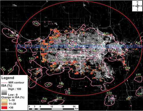
We also used the normalized difference vegetation index (NDVI) multi-date false colour composites from 2010 Landsat 5 Thematic Mapper data and the National Land Cover Data (NLCD) percent impervious surface area (percentage ISA) data from 2001 and 2006 (Fry et al. 2011) to provide finer spatial resolution (30 m) characterisation of the targeted urban landscapes ().
Figure 1. Blue transect across Omaha shown overlaying the 2001 percent impervious surface area (percentage ISA) and 2006 percentage ISA change along with contours derived from MODIS band 23 radiance (W m–2 μm−1 sr−1) on day 215 of 2009 in pink, with radiance values in green.
We selected west-to-east transects across each city that captured a rural-to-urban-to-rural land-use gradient. Transects were composed of 1-km² grid cells that approximated the nominal spatial resolution of the MODIS data. We calculated the moving average of percentage ISA within each grid cell and collected the corresponding MIR radiance values. Viewing geometry data were collected to explore the influence on day-to-day fluctuations in observed MIR radiance. Data were filtered by using the MODIS cloud mask product (MYD35) as well as a VZA threshold of ≤60°. We were then able to explore the relationship between MIR radiance and percentage ISA as a function of time of year and of sensor VZA. Solar zenith angle was also analysed and found to demonstrate a positive relationship with radiance; however, this is linked to insolation as a function of time of year.
3. Results
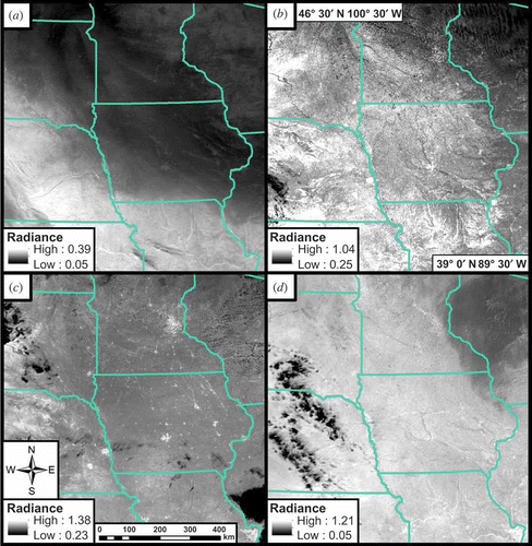
A distinct seasonal progression in MIR radiance is apparent in the Northern Great Plains. This seasonality arises from the interaction of annual cycles of insolation, weather and vegetation (Cracknell and Boyd Citation2009). Seasonal water content, particularly of vegetation, is one of the main influences of seasonality on MIR radiance (Boyd and Duane Citation2001). During the winter months, snow cover greatly influences MIR radiance by lowering it (). Note that the dynamic range of radiance in the snowy January scene () is roughly half to a third of the range of scenes from other seasons (–2(d)). Early in the growing season, MIR radiance is high across much of the region due to expanses of bare soil because agricultural landscapes lack a fully developed plant canopy (). Similar spectral properties between soils, dried vegetation and impervious surfaces make urban detection difficult during this period. As the plant canopy develops and the vegetated fraction approaches a seasonal maximum, the land surface darkens in the MIR (). The resulting contrast between MIR-dark green vegetation and MIR-grey impervious surfaces allows urbanized areas to emerge from the rural matrix of agricultural land uses. As crops mature, dry, and are harvested, the dried vegetation and exposed soils increase MIR radiance across the region (). Consequently, it again becomes more difficult to differentiate between rural and urban landscapes. Other studies of MIR have also noted the temporal variability in MIR radiation, attributed to the reflected component (Boyd and Duane Citation2001).
Figure 2. Seasonal progression of MIR radiance from MODIS band 23 over the Northern Great Plains in 2009. The influences of snow cover (a; 15 January), bare soils and dried vegetation (b; 28 June) (d; 29 September) and the urban/rural contrast (c; 3 August) on observed MIR radiance (W m−2 μm−1 sr−1) are evident. A separate 2% stretch has been applied to each image.
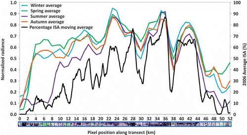
illustrate the influence of seasonality and land use on observed MIR radiance across the Omaha study transect. Normalizing the radiance across the transect reveals a large drop in radiance at the ends of the transect during the summer, but a consistent spatial pattern over areas with high percentage ISA throughout the year ().
Figure 3. Seasonal MIR radiance in 2009 and percentage ISA from 2006 (second y-axis) illustrate the differential variation from green vegetation and impervious surfaces. (Image, below the x-axis) Landsat 5 NDVI false colour composite from 2009 (R = 21 April, G = 26 July, B = 28 September) over Omaha, NE transect showing areas of vegetation that appear green and impervious surfaces that appear in shades of magenta to dark grey. Black areas at left are open waterbodies.
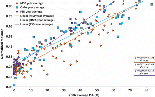
MIR radiance increases with percentage ISA, climaxing at highly built-up sections of central and downtown Omaha (). A similar positive relationship exists between percentage ISA and MIR radiance in each city ().
Figure 4. Normalized yearly average MIR radiance for the three city transects in 2009 vs. percentage ISA from 2006.
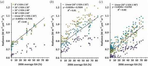
Viewing geometry plays a key role in observed MIR radiance (). Spectral contrasts are higher at lower VZAs. shows that there is a greater inter-pixel variation in MIR radiance in the lower VZAs (yellow: VZA 0°–16° and blue: VZA 16°–32°). The seasonality of MIR radiance is more evident at higher VZAs due to increased vegetation fraction being detected.
Figure 5. Summer 2009 average MIR radiance as a function of average percentage ISA in 2006 grouped by VZA class for (a) Sioux Falls, SD; (b) Omaha, NE; and (c) Minneapolis-St. Paul, MN. Less variation and much lower MIR radiance is exhibited at higher VZAs.
4. Discussion
The influence of sensor VZA on observed MIR radiance arises from changing relative proportions of surface types, especially at coarse spatial resolution in which many scene objects are captured within a single pixel (Boyd and Petitcolin Citation2004). For example, a pixel acquired at nadir (VZA = 0°) will detect MIR reflectance and emittance from the soil surface in croplands, but as the VZA becomes increasingly off-nadir (VZA→60°), less soil surface and more vegetation is observed. A sparser crop canopy may show higher sensitivity to VZA. In tall building districts, the VZA influences MIR dynamics in two ways: (1) emittance from urban canyons and (2) reflectance from varying proportions of sunlit surfaces being sensed.
Likewise, sensor VZA affects the observed land surface temperature (LST) collected by the sensor (Smith et al. Citation1997). Variations of up to 8 K have been found in the temperature of corn canopy surfaces (Lagouarde et al. Citation1995). A study of LST in crop fields found the optimal VZA for corn (maize) canopy to be around 50° from zenith (Smith et al. Citation1997). This crossover point limits errors in LST caused mostly by soil interference (Smith et al. Citation1997); thus, we see in much higher average radiance at lower VZAs and much lower average radiance and less inter-pixel variation in the highest VZA category (48°–64°) due to increased detection of the vegetated land surface. Given the strong influence of VZA on observed MIR radiance, it is necessary to account for VZA in any compositing scheme for MIR imagery. We expect that MIR radiance will be particularly sensitive to VZA as well as view azimuth angle in cities with clusters of tall buildings that compose urban canyons.
The seasonal contrast in the MIR between green vegetation and impervious surfaces as well as the positive relationship between MIR radiance and percentage ISA suggests that the MIR could be used for similar purposes as percentage ISA data, such as urban change detection, albeit at a relatively coarse (~1 km) spatial resolution. Significant inter-annual stability can be seen in this seasonal contrast, which is important for monitoring urbanization over time (Henebry Citation2006). However, annual differences in water content of vegetation and the proportion of exposed soil can also affect year-to-year MIR radiance (Cracknell and Boyd Citation2009) and will contribute to spatio-temporal heterogeneity in MIR radiance.
Limitations of the MIR for urban remote sensing include coarse spatial resolution of MIR data (~1 km) due to the scarcity of MIR photons in both solar and terrestrial radiation fluxes (Henebry Citation2006). Also, difficult physical optics leads to low signal-to-noise ratios in observations. The obscuring effects of dust and certain cloud types limit data collection. Lastly, soils in semiarid to arid environments can appear too bright to enable separation of urbanized settlements from bare soil (Henebry Citation2006).
One vital advantage of the MIR is the ability to penetrate anthropogenic haze, smog and light smoke (Libonati et al. Citation2012). Moreover, there is relatively little attenuation in the MIR from atmospheric water vapour (Boyd and Petitcolin Citation2004, Libonati et al. Citation2012). Combined with the seasonal contrast between vegetated and impervious surfaces, the potential exists for monitoring urban growth, particularly in the developing world and other areas with high rates of air pollution. In the United States alone nearly 160 million people live in counties not compliant with federal air pollution regulations (Watson Citation2004).
Monitoring human settlements using remote sensing is becoming increasingly important in an urbanizing world. Over 50% of the people worldwide now live in urban areas; it is forecast that 70% will live in cities by 2050 (Seto and Shepherd Citation2009). There is a strong demand for enhanced remote-sensing techniques and options for monitoring urban growth (Herold Citation2009). When shorter wavelengths fail to sense urban areas due to obscuring pollutants, MIR imagery may be an option to monitor urban change. We have demonstrated here that both the time of year and the VZA can strongly affect observed MIR radiance of urbanized landscapes; thus, it is important to take into account these factors for urban remote sensing.
Acknowledgements
The authors thank the anonymous reviewers for their help.
Funding
Research was supported in part by a SDSU Honors College Undergraduate Research Grant, the GSCE Center Scholars Programme and NASA grant [NNX12AM89G].
References
- Belward, A.S., 1991, Spectral characteristics of vegetation, soil and water in the visible, near-infrared and middle-infrared wavelengths. In Remote Sensing and Geographical Information Systems for Resource Management in Developing Countries, A.S. Belward and C.R. Valenzuela (Eds.), pp. 31–53 (Dordrecht: Kluwer Academic Publishers).
- Boyd, D.S. and Duane, W.J., 2001, Exploring spatial and temporal variation in middle infrared reflectance (at 3.75 μm) measured from the tropical forests of west Africa. International Journal of Remote Sensing, 22, pp. 1861–1878.
- Boyd, D.S. and Petitcolin, F., 2004, Remote sensing of the terrestrial environment using middle infrared radiation (3.0–5.0 μm). International Journal of Remote Sensing, 25, pp. 3343–3368.
- Cracknell, A.P., 1997, The Advanced Very High Resolution Radiometer: AVHRR (Bristol, PA: Taylor & Francis).
- Cracknell, A.P. and Boyd, D.S., 2009, Interactions of middle infrared (3–5 μm) radiation with the environment. In The SAGE Handbook of Remote Sensing, T. Warner, M. Nellis and G. Foody (Eds.), pp. 51–64 (London: SAGE Publications).
- Fry, J., Xian, G., Jin, S., Dewitz, J., Homer, C., Yang, L., Barnes, C., Herold, N. and Wickham, J., 2011, Completion of the 2006 National Land Cover Database for the conterminous United States. Photogrammetric Engineering & Remote Sensing Journal, 77, pp. 858–864.
- Henebry, G.M., 2006, Mapping human settlements using the mid-IR: advantages, prospects, and limitations. In Urban Remote Sensing, Q. Weng and D. Quattrochi (Eds.), pp. 339–355 (Boca Raton, FL: CRC Press).
- Herold, M., 2009, Some recommendations for global efforts in urban monitoring and assessments from remote sensing. In Global Mapping of Human Settlement, P. Gamba and M. Herold (Eds.), pp. 11–23 (Boca Raton, FL: CRC Press).
- Kaufman, Y.J. and Remer, L.A., 1994, Detection of forests using mid-IR reflectance: an application for aerosol studies. IEEE Transactions on Geoscience and Remote Sensing, 32, pp. 672–683.
- Kerber, A. and Schutt, J., 1986, Utility of AVHRR channels 3 and 4 in land-cover mapping. Photogrammetric Engineering and Remote Sensing, 52, pp. 1877–1883.
- LAADS, 2010, MYD021KM Level 1B Calibrated Radiances (Greenbelt, MD: Goddard Space Flight Center).
- Lagouarde, J., Kerr, Y. and Brunet, Y., 1995, An experimental study of angular effects on surface temperature for various plant canopies and bare soils. Agricultural and Forest Meteorology, 77, pp. 167–190.
- Libonati, R., Dacamara, C.C., Pereira, J.M.C. and Peres, L.F., 2012, Retrieving middle-infrared reflectance using physical and empirical approaches: implications for burned area monitoring. IEEE Transactions on Geoscience and Remote Sensing, 50, pp. 281–294.
- LPDAAC, 2010, Landsat 5 Thematic Mapper (South Dakota: USGS EROS Data Center).
- Lucas, R., Honzak, M., Curran, P., Foody, G.M. and Nguele, D., 2000, Characterizing tropical forest regeneration in Cameroon using NOAA AVHRR data. International Journal of Remote Sensing, 21, pp. 2831–2854.
- NOAA, 2013, Advanced Very High Resolution Radiometer-AVHRR. Available online at: http://noaasis.noaa.gov/NOAASIS/ml/avhrr.html (accessed 13 May 2013).
- Petitcolin, F., Nerry, F. and Stoll, M.-P., 2002, Mapping directional emissivity at 3.7 μm using a simple model of bi-directional reflectivity. International Journal of Remote Sensing, 23, pp. 3443–3472.
- Petitcolin, F. and Vermote, E., 2002, Land surface reflectance, emissivity and temperature from MODIS middle and thermal infrared data. Remote Sensing of Environment, 83, pp. 112–134.
- Roberts, D.A. and Herold, M., 2004, Imaging spectrometry of urban materials. Infrared Spectroscopy in Geochemistry, Exploration and Remote Sensing, Mineral Association of Canada, Short Course Series, 33, pp.155–181.
- Rogan, J. and Chen, D., 2004, Remote sensing technology for mapping and monitoring land-cover and land-use change. Progress in Planning, 61, pp. 301–325.
- Roy, D.P., 1999, Multi-temporal active-fire based burn scar detection algorithm. International Journal of Remote Sensing, 20, pp. 1031–1038.
- Salisbury, J.W. and D’aria, D.M., 1994, Emissivity of terrestrial materials in the 3–5 μm atmospheric window. Remote Sensing of Environment, 47, pp. 345–361.
- Seto, K.C., and Shepard J.M., 2009, Global urban land-use trends and climate impacts. Current Opinion in Environmental Sustainability, 1, pp. 89–95.
- Smith, J.A., Chauhan, N.S., Schmugge, T.J. and Ballard, J.R., 1997, Remote sensing of land surface temperature: the directional viewing effect. IEEE Transactions on Geoscience and Remote Sensing, 35, pp. 972–974.
- Tucker, C.J., Holben, B.N. and Goff, T.E., 1984, Intensive forest clearing in Rondonia, Brazil, as detected by satellite remote sensing. Remote Sensing of Environment, 15, pp. 255–261.
- US Census Bureau, 2010, 2010 Census (Washington, DC: Department of Commerce).
- Watson, T., 2004, EPA: half of USA breathing illegal levels of smog. Available online at: http://usatoday30.usatoday.com/weather/news/2004-04-15-air-quality-ap_x.htm (accessed 20 December 2012).
- Xiong, X., Wenny, B.N., Wu, A., Barnes, W.L. and Salomonson, V.V., 2009, Aqua MODIS thermal emissive band on-orbit calibration, characterization, and performance. IEEE Transactions on Geoscience and Remote Sensing, 47, pp. 803–814.