Abstract
In this paper, we developed empirical relationships between crown closure and Landsat Thematic Mapper (TM) and IKONOS spectral response in a forest ecosystem in Turkey. The linear relationships between the crown closure and satellite images were examined and for that the normalized difference vegetation index (NDVI) was generated for correlation analysis. Satellite images were georeferenced with respect to corresponding forest stand type maps for the same area. The digital numbers (DNs) in all bands were positively correlated with the crown closure in Landsat-7 ETM image. Regarding the Landsat ETM+, the DN of NIR band (band 4) had the highest correlation coefficient value with the crown closure (r = 0.715), and the DN of blue band (band 1) had the lowest correlation value with the crown closure (r = 0.373) and explains 51.1% and 13.9% of data variability, respectively, in Landsat-7 ETM image. In IKONOS image, the DNs in three bands (red, green and NIR) were positively correlated with the crown closure at the level of r = 0.385, r = 0.359 and r = 0.829, respectively. The NIR band of the Landsat-7-ETM + image showed the highest correlation with the NDVI (r = 0.886) and the red band had the lowest correlation with the NDVI (r = 0.419), while the IKONOS image showed that the NIR band had the highest correlation with the NDVI (r = 0.781) and the green band resulted in the lowest correlation with the NDVI (r = 0.367). Results also indicated that the relationships between the crown closure and the NDVIs of Landsat-7 ETM and IKONOS were positively correlated with r = 0.794 and r = 0.871, respectively.
Introduction
Applications of remote sensing in forest resources are presented in four categories that include classification of land use/forest cover, estimation of forest inventory parameters, detection of forest change over time, and provision of data to forest modeling (Franklin Citation2001). Remote sensing applications also play a vital role in meeting information needs for ecosystem-based forest management planning activities (Franklin Citation2001). On the other hand, many forest inventory variables such as crown closure, age, leaf area index, and stand development stages are critical factors for building many climate, economic, and ecological models (Liang Citation2004). In this context, remote sensing data provides us with a powerful means to monitor the spatial and temporal structure and function of forest ecosystems.
Forest stands are discriminated by differences in species composition, development stages and crown closure in Turkey. Crown closure is defined as the percentage of forest canopy projected to a horizontal plane over a unit ground area, and becomes a very important parameter in developing forest, ecological, hydrological, and climate models (Xu et al. Citation2003). However, its measurement in the field is difficult, time-consuming, and expensive (Pu et al. Citation2003; Xu et al. Citation2003). Remote sensing is an alternative way to field measurements in accurate crown closure estimation, because satellite remotely sensed data has supplied large-coverage forest information for low cost (Franklin et al. Citation2003).
The objective of this study is to investigate the relationship between crown closure and normalized difference vegetation index (NDVI) using two satellite remote sensing data, Landsat Thematic Mapper (TM) and IKONOS. As reference data, we used forest stand type maps digitized from the forest management plans. The major objective is to compare performances of Landsat and IKONOS images for extracting stand crown closure using NDVI.
Materials and methods
Study area
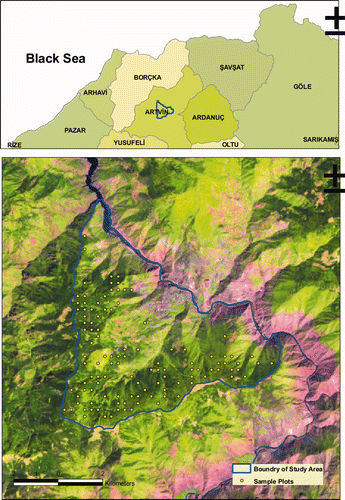
The research area of Artvin-Merkez State Forest Enterprise covers Genya Mountain forests within the management district of Artvin-Merkez State Forest Enterprise, between 41°32′00″–41°07′30″ north latitudes and 41°32′00″–41°53′00″ east longitudes, an area within the Eastern Black Sea region of Turkey (). The study area covers 5232 ha. Elevation ranges from 750 to 2047 m with an average of 1430 m. The study area situates on a steep topographic surface (characterized by a high steep and rough terrain area), with a slope ranging from 32% to 90%, with an average of 65%. The winters are mild and wet, and the summers are relatively cool and dry. Mean annual temperature is 6.6°C and the precipitation is 1157 mm. Main soil types are sandy clay loam, clay loam, and sandy loam. The study area is covered with the mixed stands of spruce (Picea orientalis) and beech (Fagus orientalis), and pure stands of spruce (Picea orientalis).
Figure 1. Map of the study area.
Acquisition of remotely sensed data
The data used in this study involve medium (Landsat-7 ETM satellite image, acquired on 10 July 2000) and high resolution (IKONOS satellite image, acquired on 10 July 2004) satellite data and 112 sampling points. When the satellite images were taken, the weather conditions were quite good and there was no cloud area on the satellite images. Additionally, forest stand type map at 1:25000 scale for 2002 forest cover type map was used to determine the crown closure classes. The forest stand map was derived from interpreting aerial photographs, high resolution satellite images, and field survey. These maps’ data were digitized and processed using a geographic information system (ArcInfo v9.0) with a maximum root mean square (RMS) error of 15 m. Spatial database consists of stand types, which is characterizing crown closure, stand age, and development stages. Forest stand maps were produced in raster format by Forest Management Teams in Turkey.
Image processing
First of all, subsets of satellite images were orthorectified using 1:25000 scale topographical maps with UTM projection zone 37 (ED 50 datum) using the first order nearest neighbor rules. A total of ground control points (20 ground point for Landsat-7 ETM+ and 30 ground point for IKONOS) were used to register the images subset with the rectification error of less than 1 pixel. The images were analyzed through image-to-image registration technique with rectification errors of less than 0.5 pixel with Erdas Imagine 9.1™ software.
Normalized difference vegetation index (NDVI)
Different vegetation indices from remotely sensed data have been proposed and widely used in various applications of forestry. NDVI is the one of the earliest vegetation indices that has been used in estimation of biophysical variables for forest ecosystems (Liang Citation2004). The NDVI ratio is calculated by dividing the difference in the near infrared (NIR) and red color bands by the sum of the NIR and red bands for each individual pixel in the image as follows:
Here, NIR is the reflectance of the near-infrared bands, and RED is the reflectance of red the band.
Results
Crown closure prediction by single band
For each individual of the 112 sample pixels, we exposed the DNs from the six bands of the Landsat-7 ETM image including the blue, green, red, NIR and two middle infrared spectral ranges, and the four bands of the IKONOS image including the blue, green, red and NIR. Linear relationships between bands and crown closure values as to each satellite images can be shown from the scatter plots (, 3). The correlation coefficient (r), R-squared (R2), and residual standard errors (RSE) are reported in and . The DNs in all bands are positively correlated with the crown closure. However, the DN of NIR band (band 4) has the highest correlation with crown closure (r = 0.715) and the DN of blue band (band 1) has the lowest correlation with crown closure (r = 0.373) and explains 51.1% and 13.9% of data variability, respectively, in Landsat-7 ETM image. In IKONOS image, the DNs in three bands (red, green and NIR) are positively correlated with crown closure r = 0.385, r = 0.359 and r = 0.829, respectively. The NIR band has a high positive correlation with crown closure. The R2 value indicates that 69% of the variance in percent crown closure is explained by the regression on IKONOS 4 response. There is little relationship in blue band of IKONOS image.
Figure 2. Scatter plots of crown closure (%) against DN of each ETM image band.
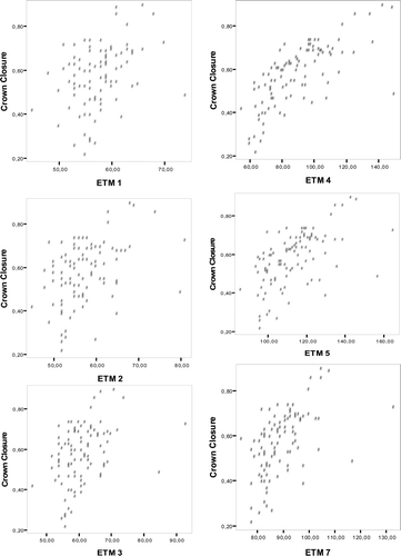
Table 1. Statistical analysis between single bands with crown closure in Landsat ETM image.
Table 2. Statistical analysis between single bands with crown closure in IKONOS image.
Vegetation index (NDVI) relationships by single band
In this study, the correlation analysis with NDVI and DN values was made from Landsat-7 ETM and IKONOS satellite images (, ). Linear relationships between bands and NDVI values in both satellite images can be seen from the scatter plots (, 5). The NIR band has a high correlation with the NDVI (r = 0.886) and the red band has a low correlation with the NDVI (r = 0.419) in Landsat-7 ETM image. In IKONOS image, the NIR band has a high correlation with the NDVI (r = 0.781) and the green band has a low correlation with the NDVI (r = 0.367).
Figure 3. Scatter plots of crown closure (%) against DN of each IKONOS image band.
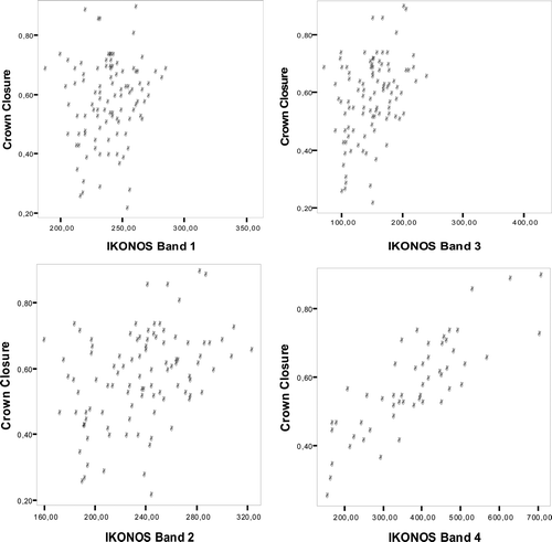
Figure 4. Scatter plots of NDVI against DN of each ETM image band.
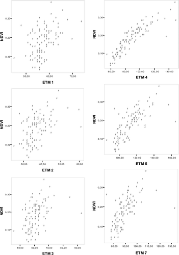
Figure 5. Scatter plots of NDVI against DN of each IKONOS image band.
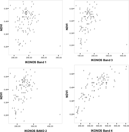
Table 3. Correlation analysis between NDVI and digital number values in ETM image.
For the same land use and land cover classes, the ETM + NDVI values range between 0.419 and 0.886, and IKONOS NDVI values range between 0.135 and 0.610.
Crown closure and NDVI relationships
In addition, the relationships between crown closure and NDVI obtained from Landsat-7 ETM and IKONOS satellite images were evaluated (). The linear relationships between crown closure and NDVI values obtained from both satellite images can be seen from the scatter plots (). Results indicate that the relationships between crown closure and NDVIs of Landsat-7 ETM and IKONOS were positively correlated r = 0.794 and r = 0.871, respectively. The R2 values indicate that 63% and 76% of the variance in percent crown closure is explained by the regression on NDVI and IKONOS images response, respectively.
Figure 6. Scatter plots of crown closure against NDVI obtained from Landsat and IKONOS images.
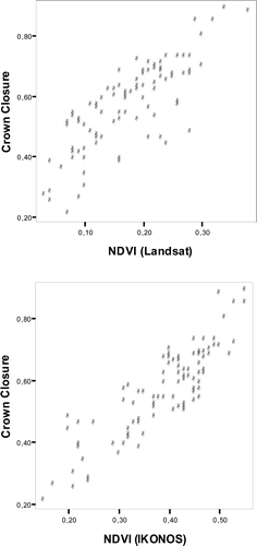
Table 4. Correlation analysis between NDVI and digital number values in IKONOS image.
Table 5. Correlation analysis between NDVI (Landsat)-NDVI (IKONOS) and crown closure.
Discussion
In this paper, we first developed empirical relationships between crown closure and the two different sensors: Landsat TM and IKONOS spectral response for a forest ecosystem, Turkey. Second, the correlation analysis with NDVI and DN values was conducted in Landsat-7 ETM and IKONOS satellite images. Finally, we investigated the relationship between crown closure and NDVI using two satellite remote sensing data.
Linear relationships between bands and crown closure values in both satellite images showed that the DNs in all bands are positively correlated with the crown closure in Landsat-7 ETM image. In IKONOS image, the DNs in three bands (red, green and NIR) are positively correlated with crown closure and there was no relationships with blue band. In both Landsat and IKONOS satellite images, the NIR band has a high correlation with the NDVI, r = 0.886 and r = 0.781, respectively.
These results are quite comparable to similar other research results. Butera (Citation1986) tested the correlation of crown closure with the signal response of individual Thematic Mapper Simulator (TMS) bands for selected forest sites in the San Juan National Forest, Colorado. He found that the correlations were all negative, with the strongest coefficients occurring for TMS bands, 1, 5, and 7 (0.764, 0.807, and 0.763, respectively). The correlation between crown closure and TMS band 4 (r = 0.142) was the lowest. Xu et al. (Citation2003) examined the linear relationship between crown closure and digital values of each band of the TM image in Tulare County, California. TM band 3 (red band) had the highest correlation with crown closure (r = −0.828) and explained 68.7% of data variability. However, the DN of the NIR band (band 4) has a low correlation with crown closure (r = 0.222). Danson (Citation1987) found a poor relationship between SPOT HRV NIR reflectance and forest crown closure in a forest consisting of Corsican pine (Pinus nigra var. maritime) stands in England. On the other hand, Franklin and McDermid (Citation1993) found a significant relationship (R2 = 0.45) between SPOT HRV measured reflectance and lodgepole pine stands in Alberta.
The results of this study also prove that the higher spatial resolution of the IKONOS contributed to the wider range in NDVI values when compared to the lower spatial resolution of Landsat ETM+. In a similar study, Thenkabail (2010) shows that ETM+NDVI values range between −0.21 to 0.46 and IKONOS NDVI range between −0.07 and 0.64; a very minor difference of 0.03 in the dynamic ranges of two sensors.
Results also indicated that the relationships between crown closure and NDVIs of Landsat-7 ETM and IKONOS were positively correlated with r = 0.794 and r = 0.871, respectively. In a similar study, Zeng et al. (Citation2008) used the low spatial resolution MODIS data in two different years. After a correlation analysis, they found that NDVI shows the highest linear correlation with the crown closure in the Three Gorges region of China for both 2002 (r = 0.61) and 2004 (r = 0.57). Based on the 25 sample sites, validations show that this method yields similar accuracies for both years (R2 = 0.614 and RMSE = 0.060 in 2002; R2 = 0.631 and RMSE = 0.052 in 2004).
Conclusion
Remote sensing has been a valuable source of information in mapping and monitoring forest activities and forest ecosystem structure over the past several decades. Depending on the need for increased amounts and quality of information about forest ecosystems, remote sensing technology will continue to improve and be critical in the future (Franklin Citation2001). Detecting and understanding forest ecosystem dynamics are increasingly important for the sustainable management of natural resources and, especially, of forest resources. Thus, it is important that both the composition and configuration of forest ecosystems should be quantitatively evaluated using remotely sensed data for effective forest ecosystem management in a changing world.
References
- Butera , MK . 1986 . A correlation analysis and regression analysis of percent canopy closure versus TMS spectral response for selected forest sites in the San Juan National Forest, Colorado . IEEE T Geosc Remote , 24 ( 1 ) : 122 – 129 .
- Danson , FM . 1987 . Preliminary evaluation of the relationships between SPOT-1 HRV data and forest stand parameters . Int J Remote Sens , 8(10) : 1571 – 1575 .
- Franklin , SE . 2001 . Remote sensing for sustainable forest management , 407 Boca Raton , FL : Lewis Publishers .
- Franklin , SE , Hall , RJ , Smith , L and Gerylo , GR . 2003 . Discrimination of conifer height, age and crown closure classes using Landsat-5 TM imagery in the Canadian Northwest Territories . Int J Remote Sens , 24 ( 9 ) : 1823 – 1834 .
- Franklin , SE and McDermid , M . 1993 . Empirical relations between digital SPOT HRV and casi imagery and lodgepole pine (Pinus contorta) forest stand parameters . Int J Remote Sens , 14(12) : 2331 – 2348 .
- Liang , S . 2004 . Quantitative remote sensing of land surfaces , 534 Hoboken (NJ) : John Wiley & Sons Inc .
- Pu , R , Xu , B and Gong , P . 2003 . Oakwood crown closure estimation by unmixing Landsat TM data . Int J Remote Sens , 24 ( 22 ) : 4433 – 4445 .
- Thenkabail , PS. 2010 . Inter-sensor relationships between IKIONOS and Landsat-7 ETM + NDVI data in three ecoregions of Africa . Int J Remote Sens , 25 ( 2 ) : 389 – 408 .
- Xu , B , Gong , P and Pu , R . 2003 . Crown closure estimation of oak savannah in a dry season with Landsat TM imagery: comparison of various indices through correlation analysis . Int J Remote Sens , 24 ( 9 ) : 1811 – 1822 .
- Zeng , Y , Schaepman , ME , Wu , B , Bruin , S and Clevers , GPV . 2008 . “ Change detection of forest crown closure using an inverted geometric-optical model and scaling ” . In The International Archives of the Photogrammetry, Remote Sensing and Spatial Information Sciences , Edited by: Chen , J , Jiang , J and van Genderen , J . 6 Göttingen , , Germany : Copernicus Publications/ISPRS . Part B7