
Abstract
The primary objective of this study was to ascertain, through analysis of accessibility and development potential, which activity centres should be prioritised to support decentralisation of jobs, encourage better integration of transport and land use and ultimately aid the evaluation of a more compact, consolidation and connected city. In doing so, this study evaluated and compared the existing accessibility of different geographic units across the city, including the 34 activity centres identified by the Government of Australia, by the two most frequently use transport modes, namely – public transport and car. The analysis of this study has two parts. Firstly, an isochrone-based measure of accessibility was used for an accessibility modelling across the Perth Metropolitan Area in Western Australia. Secondly, using six node-place based indicators, this paper also endeavoured to prioritise the geographic units that are already better served by public transport, as indicated by the accessibility analysis. Multi-criteria weighed scoring method was applied to calculate a score out of 100 for each of the geographic units. The results of this analysis could help to identify activity centre(s) and other areas in Perth, if any, with higher potentials of being a Transit Oriented Development (TOD) supportive activity centre.
Highlights
| • | Existing accessibility of the activity centres and potential areas was assessed. | ||||
| • | Prioritisation of the areas with higher public transport accessibility was determined. | ||||
| • | Isochrone-based measures of accessibility were used for the accessibility modelling. | ||||
| • | A multi-criteria weighted scoring method was applied to the node-place indicators for the prioritisation. | ||||
| • | Dominance of Perth Central Business District and surroundings as highly public transport accessible areas. | ||||
| • | There are certain areas across the Perth with better potentials to be activity centres. | ||||
1. Introduction
The concept of accessibility has been around for long in the transport research arena and has also been used in a broad variety of applications, including access to health care services (Cimaroli, Páez, Newbold, & Heddle, Citation2012; Horner & Mascarenhas, Citation2007), social exclusion (Bocarejo & Oviedo, Citation2012; Preston & Raje, Citation2007; Scott & Horner, Citation2008) and food deserts (Bertrand, Therien, & Cloutier, Citation2008; Páez, Mercado, Farber, Morency, & Roorda, Citation2010b). The concept gained such popularity due to the fact that it provides a consolidated measure of the interrelation between land use and transport systems (Cascetta, Cartenì, & Montanino, Citation2016; Dong, Ben-Akiva, Bowman, & Walker, Citation2006; Morris, Dumble, & Wigan, Citation1979; Wang, Monzon, & Ciommo, Citation2015). The community of planning and transport practitioners agree that accessibility is a ‘measure of spatial separation of human activities’ (Morris et al., Citation1979, p. 91). Specifically, it denotes the ease of reaching facilities required by individuals to perform their daily activities with a choice of travel (Dong et al., Citation2006; Geurs & van Wee, Citation2004; Handy & Niemeier, Citation1997; Kitamura, Akiyama, Yamamoto, & Golob, Citation2001; Kwan & Weber, Citation2003; Scott and Horner, Citation2008). Since accessibility is a function of land uses and transport systems connecting the land uses, it was previously used to evaluate and compare the performance of transport projects to identify areas that are currently under-provided (Horner & Mascarenhas, Citation2007; Kwan, Citation1998; Morris et al., Citation1979). In many cases around the world, measures of accessibility became an important tool in developing policies for urban and regional planning (Páez, Scott, & Morency, Citation2012) and, thus is being used as a fundamental basis for dialogue between transport authorities and actors in the supply of transport services that would eventually improve the accessibility through the development of transport networks (Cascetta et al., Citation2016; Halden, Citation2002; Wang et al., Citation2015).
The accessibility measures evolved in time and there are numerous classifications (Curtis & Scheurer, Citation2010; Dong et al., Citation2006; Geurs & van Wee, Citation2004; Handy & Niemeier, Citation1997; Miller, Citation1991; Páez, Citation2004; Páez, Mercado, Farber, Morency, & Roorda, Citation2010a; Páez, Moniruzzaman, Bourbonnais, & Morency, Citation2013; Páez et al., Citation2010b, 2012; Rietveld & Bruinsma, Citation1998). Handy and Niemeier (Citation1997) summarised the accessibility measures in three categories, namely – isochrone or cumulative opportunity, gravity-based, and utility-based (See for more details: Handy & Niemeier, Citation1997). These measures are capable of providing insights into the accessibility of particular facilities (e.g. hospital) or zones (e.g. Census Tracks) or individuals.
Using the concept of time-geography (e.g. space-time prism), researchers (Kim & Kwan, Citation2003; Kwan, Citation1998, 1999; Kwan, Murray, O’Kelly, & Tiefelsdorf, Citation2003; Levinson, Citation1998; Miller, Citation1991, 1999) introduced another measure of accessibility which they term the space-time measure of accessibility. The space-time accessibility measure uses individual’s location (space) and activity sequence (time) as constraints to limit activity participations by the individual. Dong et al. (Citation2006) introduced an ‘activity-based’ measure of accessibility which is actually an improved version of the utility-based measure where they incorporated the concept of activity sequencing in calculating accessibility. More specifically, instead of considering discrete trips made by individuals, the activity-based measure accounts for all activities performed by an individual throughout a day and the sequencing of those activities. It also considers trip chaining for the trips made the individual. As such, activity-based measures are more rigorous than discrete measures.
There are however trade-offs between data requirements and ease of communicating the results for policy-making (Handy & Clifton, Citation2001). For instance, the simplest isochrone-based measure requires fewer data for calculations and is more easily communicated to the general public, although it ignores individual’s activity scheduling. Conversely, the complex space-time prism-based measure demands sophisticated data and is harder to understand but it is richer and more realistic. The current paper therefore applies a simple isochrone-based measure in calculating the accessibility of activity centres (to be defined in the following paragraph). This measure of accessibility was widely used in the past for identifying spatial differences, for highlighting places with good access or places that may need interventions to increase their accessibility (Lopez, Gutierrez, & Gomez, Citation2008; Moniruzzaman & Páez, Citation2012; O’Sullivan, Morrison, & Shearer, Citation2000; Raja, Ma, & Yadav, Citation2008; Straatemeier, Citation2008; Straatemeier & Bertolini, Citation2008; Wang & Luo, Citation2005).
In the urban studies literature, an activity centre is defined as an area with higher concentrations of employment than the concentration in its surrounding areas (Casello & Smith, Citation2006). The Government of Western Australia identified 34 activity centres across the Perth Metropolitan Area. They also promoted Transit Oriented Development (TOD) across the city where activity centres would be well-connected by public transport infrastructure, with the future goal to improve the growth of the activity centres by means of urban regeneration and densification of existing built-up areas, which they referred as a ‘Network City’ (State of Western Australia, Citation2010). In doing so, the state planning document outlines a spatial planning framework and strategic plan based on transforming the linear development into a more compact and connected development of the city, with particular emphasis on the activity centres, with good coverage of public transport services (State of Western Australia, Citation2010). This however prompts a research question how the state government would select activity centres in different phases of their development. Specifically, the planning document neglects highlighting which activity centres have higher TOD potential and therefore should be prioritised for future development. Furthermore, it is also important to identify if there are any other areas across the city that have better potentials for TOD however the planning document did not identify them as activity centres.
Therefore, the primary objective of this study was to ascertain, through analysis of accessibility and development potential, which activity centres should be prioritised to support decentralisation of jobs, encourage better integration of transport and land use and ultimately aid the evaluation of a more compact, consolidation and connected city. In doing so, this study evaluated and compared the existing accessibility of different geographic units across the city, including the 34 activity centres, by the two most frequently use transport modes, namely – car and public transport. Furthermore, using six node-place based indicators (Bertolini, Citation1999), this paper also identified the geographic units that are already better served by public transport, as indicated by the accessibility analysis. The results of this analysis could help to highlight areas with higher potentials of being a TOD supportive activity centre.
2. Literature review
2.1. Analysis of accessibility
Substantial scholarly work has demonstrated the role of transport accessibility in enhancing the functionality and sustainability of urban structures, increasing liveability and quality of life of the citizens (Beimborn, Greenwald, & Jin, Citation2003; Burns & Golob, Citation1976; Curtis, Citation2008; Horner, Citation2004; Kitamura et al., Citation2001; Kwan & Weber, Citation2008; Lau & Chiu, Citation2003). The main idea is that meeting mobility needs by offering highly accessible areas to the urban residents will provide them with opportunities to participate in community activities, reduce their need for excessive travel to reach the facilities they need, which will have beneficial effects by reducing transport negative externalities (e.g. travel costs, congestion, and environmental effects) (Beimborn et al., Citation2003; Curtis, Citation2008; Geurs & van Wee, Citation2004; Handy & Niemeier, Citation1997; Horner & Murray, Citation2002; Horner & O’Kelly, Citation2007).
Whereas the above studies report international experiences, several studies focused on accessibility modelling across Australian cities (Curtis, Citation2008; Curtis & Scheurer, Citation2010; Espada & Luk, Citation2011; Kelly et al., Citation2013; Yigitcanlar, Sipe, Evans, & Pitot, Citation2007). Geographic Information Systems (GIS)-based tools, such as Spatial Network Analysis for Multimodal Urban Transport Systems (SNAMUTS) (Curtis & Scheurer, Citation2010) and Land Use and Public Transport Accessibility Indexing (LUPTAI) (Yigitcanlar et al., Citation2007) were developed to calculate accessibility in Perth, Western Australia and Gold Coast, Queensland, respectively. The LUPTAI tool modelled the accessibility by walking and/or public transport using isochrone measure and, on the other hand, the SNAMUTS is based on multimodal transport systems and uses numerous indicators (e.g. network connectivity, 30 min catchment areas) in developing their composite accessibility measure. However, these vectors of metrics do not incorporate congestion nor account for various traffic conditions. Alternatively, their time measures are based on scheduled times of public transport services.
Another multimodal accessibility modelling tool, ARRB Accessibility Metrix (AAM), was developed to compare accessibility between two cities, namely – Melbourne and Perth (Espada & Luk, Citation2011). The AAM is based on a continuous decay function that was used to weigh the opportunities measuring accessibility. The study by Grattan Institute (Kelly et al., Citation2013) used multivariate analysis and isochrone measure to model accessibility across Australia’s four largest cities, namely – Sydney, Melbourne, Brisbane and Perth. Substantial differences were reported in the accessibility maps which is, as they explained, due to the variations in topography and transport network across the cities.
These accessibility studies conducted on different Australian Cities, including Perth (Curtis & Scheurer, Citation2010; Kelly et al., Citation2013; Yigitcanlar et al., Citation2007), focused primarily on measuring accessibility of the residential neighbourhoods (considering the number of jobs as a proxy to opportunity). This paper was, however, intended at measuring accessibility of activity centres where population (the number of residents) was used as a proxy to opportunity provided by the activity centres. In other words, instead of measuring the accessibility of the residential areas to jobs, this study primarily focused on the accessibility of the activity centres to/from residential areas (i.e. to people).
2.2. Node-place model
The node-place model was often employed in the past studies in classifying TOD supportive developments (Bertolini, Citation1999; Chorus & Bertolini, Citation2011; Kamruzzaman, Baker, Washington, & Turrell, Citation2014; Lyu, Bertolini, & Pfeffer, Citation2016; Monajem & Ekram Nosratian, Citation2015; Reusser, Loukopoulos, Stauffacher, & Scholz, Citation2008; Zemp, Stauffacher, Lang, & Scholz, Citation2011). This model characterises urban development from the perspective of nodes (e.g. transport) and places (e.g. land use). However, due to a wide variety of applications, the original node-place model (Bertolini, Citation1999) was adapted based on the available data, purpose, and context of the applications (Lyu et al., Citation2016). There are approximately 100 different indicators used in numerous studies to characterise nodes and places in urban developments across the globe. The node-place models usually enable a multi-criteria analysis employing the indicators and thus classify/evaluate the performance of TODs.
Since the purpose of this study was to identify activity centres with higher potential to be TOD supportive, we discussed only similar studies here. For example, in Brisbane, Queensland, Kamruzzaman et al. (Citation2014) used six quantitative measures of built environment (e.g. net employment density, net residential density, land use mix, intersection density, cul-de-sac density, and public transport accessibility) to classify TODs using cluster analysis. The cluster analysis identified four cluster types, viz. residential TODs, activity centre TODs, potential TODs, and unsuitable TOD locations. Moreover, the number or density of jobs (Atkinson-Palombo & Kuby, Citation2011; Pollack, Gartsman, Boston, Benedict, & Wood, Citation2014; Singh, Fard, Zuidgeest, Brussel, & Maarseveen, Citation2014; Zemp et al., Citation2011) and street intersection density (Shastry, Citation2010; Singh et al., Citation2014) were also utilised in the past studies in classifying and/or evaluating TODs. Floor/built up area ratio (Cervero & Murakami, Citation2009; Song & Deguchi, Citation2013), gross floor area/built up area of development (Cervero & Murakami, Citation2009; Ivan, Boruta, & Horák, Citation2012), and land use mix (Dittmar & Ohland, Citation2003; Singh et al., Citation2014) were also considered. Performance measures pertaining to active modes were also incorporated, for example – length of bike path/number of separate bike paths (Bertolini, Citation1999; Reusser et al., Citation2008).
3. Case study and method
3.1. Case study
Australian capital cities are experiencing an unprecedented growth in their population, for instance – two-thirds of the Australia population in 2009 lived in the capital cities (Australian Bureau of Statistics, Citation2010). Thus, in order to maintain the role of primary population attractor these capital cities are likely to experience even higher population growth in future (Newton, Citation2008). According to the 2056 population projection by Australian Bureau of Statistics (ABS), 72% of all expected growth in population will be captured by the capital cities (Major Cities Unit, Citation2010).
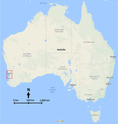
Perth is Australia’s fastest growing capital city facing substantial changes in accommodating the increase in population (Figure ). The 2056 population projection by ABS reported that Perth would be a city of just over 3.3 million people with an expected growth of 104%, the highest growth in Australia, followed by Brisbane of 103% (Australian Bureau of Statistics, Citation2008). Land availability on urban edges and traditional car travel has perpetuated a trend of urban sprawl, with declining level of accessibility. As indicated by Weller, ‘70% of new residential development still occurs at or beyond the boundaries of developed areas’ (Weller, Citation2009, p. 81), with little employment and access to services.
Figure 1. Location of Perth Metropolitan Area in the map of Australia (Source: Google Maps, 2016).
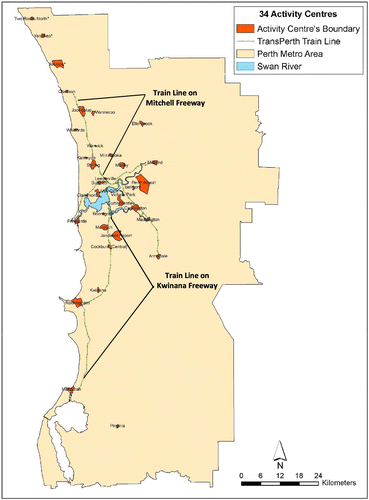
Although planning authorities in Western Australia started to acknowledge and address this issue more than a decade ago, implementation has lagged behind. In support of the implementation of the strategic direction, the Western Australian Government released the State Planning Policy ‘Activity Centres for Perth and Peel’ in 2010, making provision for planning implementation and outlining a performance-based approach for assessing activity centres (State of Western Australia, Citation2010). Figure presents the 34 activity centres (strategic, secondary, and specialised) identified in the government release.
Figure 2. Location of the 34 activity centres across the Perth Metropolitan Area (Source: Md Moniruzzaman).
3.2. Modelling accessibility
In order to measure the accessibility of existing activity centres to people and to identify new potential areas of high accessibility, isochrone-based measure of accessibility was used in this study (Handy & Niemeier, Citation1997). This measure sums the number of opportunities (e.g. number of people/jobs) that are reachable, usually by a car or public transport, within a given cost (e.g. 30 min travel time) within which no difference in accessibility exists. In reality, a cut-off value, for the cost, is selected by the analyst in an arbitrary fashion (Cervigni, Suzuki, Ishii, & Hata, Citation2008; Cinnamon, Schuurman, & Crooks, Citation2008; Gutiérrez & Gómez, Citation1999; O’Kelly & Horner, Citation2003). In this method, the accessibility of a zone represents the number of opportunities that can be reached in a given distance, travel time, or generalised cost from a location, as shown by the following equation:(1)
where wj has a value of 1 for the zones that can be reached within the given ‘budget’ (distance, time, or generalised cost), and 0 otherwise; aj represents the number of opportunities in a zone j.
3.3. Data and assumptions
The accessibility was estimated for both morning (7–9 AM) and evening (4–6 PM) peak periods and by both public transport and car travel. The data for this accessibility calculation were obtained from the Strategic Transport and Evaluation Model (STEM), the Department of Planning in Western Australia uses for land use and travel demand forecasting. The unit of analysis in the STEM is Traffic Analysis Zone (TAZ) and the model used 472 TAZs across the Perth Metropolitan Area. The travel times, through the transport networks, between zones i and j, during the peaks, were used to produce the O-D cost matrices. The travel time by public transport includes both access and egress, in-vehicle journey time from one zone to another, and waiting and transfer times. The numbers of people within the TAZs (as proxy for opportunities) were obtained from the land use forecasting component of the STEM.
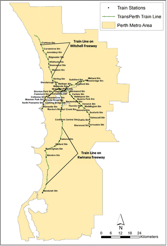
The accessibility modelling was carried out for all the TAZs across the city. To calculate the accessibility for the morning peak, we considered each TAZ as the destination and the accessibility of a TAZ is the number of people that could arrive to the TAZ from other TAZs within a given time budget. Conversely, for the evening peak, each TAZ was considered as the origin and the accessibility of a TAZ is measured as the number of people in other TAZs that are reachable with the time budget. More specifically, the direction of traffic in the morning peak was considered from individuals’ places of residence to activity centres and, in contrast, it was from activity centres to places of residence in the evening peak. The resulting continuous accessibility surface, at the TAZ level, was overlaid with the three different geographic units across the city and a weighted average of the area covered was used to estimate the accessibility of those geographic units. The geographic units include the activity centres’ notional boundaries as defined by the state’s Department of Planning, 2 km circular buffer around the centroid of the activity centres, and 2 km buffer around the 68 local train stations across the Perth Metropolitan Area. Figure shows the location of the train stations. The 2 km buffers around the activity centres and stations were decided based on the understanding that it is a reasonable bicycling distance, as suggested in the Handbook of sustainable Travel (Handy, Citation2013) and therefore the activity centres could be easily accessed by active transport.
Figure 3. Location of the 68 train stations across the Perth Metropolitan Area (Source: Md Moniruzzaman).
One important decision was required in regard to the cut-off value to be used for the isochrone-based measure of accessibility. Instead of arbitrarily assuming a threshold, such as 30 min by car or public transport, we investigated the average time commuters spent in their travel to work by different modes of transport using the latest available travel survey data in the city – the Perth and Regions Travel Survey (PARTS) 2007. An analysis of the PARTS data revealed that, on average, people spend 45 min for a one-way trip by public transport and therefore this average value was used as the cut-off value for our accessibility modelling. A similar approach was also used in the past by Moniruzzaman and Páez (Citation2012). Moreover, to ensure a direct comparability, the same time was used for modelling the accessibility by car. Finally, for easier interpretation, the unit of the calculated accessibility was changed from an absolute population value to a relative value (i.e. percentage of the total population in the city, which was 1,822,093 in 2011 as per the STEM).
3.4. Using node-place models for prioritisation
The prioritisation was conducted only for the geographic units with better public transport accessibility, based on the average of the morning and afternoon peak travel times. Good accessibility by public transport was the primary reason for this first step of filtering towards this prioritisation process. Since there is no clear definition of low/high accessibility in the existing studies, we considered a value of 10% as our cut-off point. Therefore, any unit with average public transport accessibility higher than 10%, comparable to the employment attracted to the CBD area, was considered a suitable candidate and selected for prioritisation analysis.
Six node-place related indicators (Table ) were used for this prioritisation process. Although land use mix was initially considered as one of the indicators, it was not included in the final analysis, because of its high correlation with the built-up area densities. Similarly, there were high correlations between population and labour pool densities, and road and intersection densities. Therefore, population density, land use mix, and road density were excluded from the list of indicators. These node-place indicators were extracted for the selected geographic units from different geographic layers using ArcGIS 10.3 (ESRI, Citation2014).
Table 1. Urban form and built environment indicators and their weighted score.
The indicators were divided into their deciles and each indicator was assigned a score out of 10 based on the deciles of the indicators. For instance, if the employment density of a geographic unit fell within the 6th decile for the indicator, it was allocated a value of 6 out of 10 for that indicator. Furthermore, we weighed the individual scores based on the relevance of the indicators for this particular study. For instance, the most importance feature of an activity centre, based on the definition, is the number of jobs and number of working age people in the centre. Therefore, employment density and labour pull density received higher weights compared to other indicators. For an easier comparison, we weighed all the six indicators in such a way that each geographic unit is scored out of 100 (see Table ) and ranked them based on the aggregated score.
4. Results and discussion
These results of accessibility modelling and prioritisation process are described in the sub-sections 4.1 and 4.2.
4.1. Transport accessibility
Table shows the public transport and car travel accessibility for the 34 activity centres (10 strategic metropolitan, 19 secondary, and five specialised) in Perth Metropolitan Area. As indicated, the accessibility of the centres is presented as percentage of total metropolitan population that can reach the centres (AM peak) or can reach their home from the centres (PM peak). Table was sorted based on the average accessibility by public transport, considering both morning and afternoon traffic peaks. The results indicate that Leederville has the highest accessibility by public transport, followed by Subiaco, Cannington, Cockburn Central, and Murdoch.
Table 2. Accessibility by public transport and car for the 34 activity centres (% of total population accessible in 45 min).
Given the coverage and frequency of public transport services across the city, 13 centres each ‘attract’ less than 5% of Perth residents by public transport, whereas their average car access is above 42%. The lowest travel access by both car and public transport are recorded for Two Rocks, Yanchep and Pinjarra, centres that are located further North and South of Perth and have low population and employment densities.
The highest car access occurs in Midland and around Perth airport (and the lowest on the North-South ‘corridor’), reflecting the congestion conditions prevalent in Perth and their main location on and around the Mitchell and Kwinana freeways, Mitchell and Kwinana. Low public transport access is also recorded for Perth Airport, Ellenbrook, Karrinyup, and Jandakot, where a combination of reduced supply of public transport services and sparser population are the main determinants.
Table shows the public transport and car accessibility of the 34 activity centres as in Table , however based on a distinct geography i.e. 2 km buffer. Most of the 2 km buffers (from the centre’s centroid) exceed the typical defined boundaries of the activity centres (exception Perth Airport where notational boundaries of the activity centres in Table are based on land use zoning and thus the size of each centre varies substantially. The purpose of estimating the accessibility for the 2 km buffers is to test if accessibility of these units exceeds their corresponding accessibility in Table . If this is the case, it could indicate the need for potential extensions of the notational boundaries defined by the Government of Western Australia.
Table 3. Accessibility by public transport and car for the 2 km buffer of 34 activity centres (% of total population accessible in 45 min).
Compared to Table , the average accessibility by public transit of the 2 km buffers (Table ) fell in Leederville and Cannington and it increased for Subiaco. Notably, the ranking of these top three activity centres in Table is the same as in Table . However, other centres changed their ranking considerably. The accessibility of Victoria Park increased from 7.36% (Table ) to 10.57% (Table ), where its ranking is number 4. This suggests that the activity centre of Victoria Park (considering its land use defined boundary) is surrounded by highly accessible areas that lie within the 2 km buffer around its centroid. This also suggests that people living in this activity centre can easily access to the centre by using active transport modes, such as walking and cycling, as this distance is suitable for the active modes (British Medical Association, Citation1992; Glaister, Burnham, Stevens, & Travers, Citation1998; Handy, Citation2013; The New South Wales Government, Citation2004). On the other hand, there are five activity centres that are not very accessible as centre buffers, because they are surrounded by low accessible areas: Murdoch, Fremantle, Claremont, Stirling, and Curtin/Bentley.
To identify potential areas, not already designated as Activity Centres, but with high transport accessibility by both public transport and car, a separate analysis of the 68 train station precincts (2 km circular buffer centring on the stations) was also carried out. Table shows that the train stations in the centre of Perth have the highest public transport accessibility. All of the top eight station precincts have public transport accessibility above 17% and car accessibility above 58%, which only one activity centre achieves (Leederville). Subiaco station precinct has the highest accessibility among the stations outside the Perth Central Business District (CBD), with similar values to the activity centre.
Table 4. Accessibility by public transport and car of the 68 train station precincts (% of total population accessible in 45 min).
Joondalup is the only station precinct in the Northern train corridor to Butler that is highly accessible by public transport. On the other hand, there are four highly accessible stations on the Mandurah line: Bull Creek, Murdoch, Cockburn Central, and Wellard. There are also few other highly accessible station precincts on the Armadale train line, but not on the Midland line. It is important to note that accessibility by car has not received much attention in the above discussion because of its magnitude and relatively stable values across the Tables through . Compared to the accessibility by public transport, accessibility by car is undoubtedly higher which is not surprising at all for a low-density city like Perth with its heavy reliance on private transport modes.
4.2. Prioritisation of geographic units
Table provides a combined list of all the geographic units that are ‘highly accessible’ (>10%) by public transport. In total, 20 geographic units passed the 10% threshold criterion and were considered for the prioritisation process. A final score out of 100 was calculated for each of the geographic units in Table based on the deciles of the six node-place related indicators and their assigned weights as in Table (individual scores of the indicators were not reported in this paper, for brevity).
Table 5. Combined list of all geographic unit with high public transport accessibility and their prioritisation score (% of total population accessible in 45 min).
Among the 34 activity centres, Subiaco has the highest combined score (88), even higher than Perth CBD (87). Booragoon activity centre came third in the ranking with a score of 78 and Leederville placed number 4 in this weight-based multi-criterion ranking, with a score of 68. The next most accessible activity centres are Joondalup (64) and Stirling (62). On the other hand, among the 2 km activity centre buffers, Leederville ranked number 1 with a score of 90, followed by Subiaco with a score of 80. When the results are compared between activity centres and activity centre buffers, many geographic units have close ranking position (e.g. Subiaco), others have different ranking positions and/or appear only once on the list (e.g. Leederville and Booragoon). For the 2 km station precincts, the list includes only station precincts that did not overlap with the 34 activity centres, nor with activity centre buffers. There are however situations where nearby station precincts may overlap with each other. Many new geographic units (station buffers) were found that have better public transport accessibility than the 34 activity centres or their buffers and these units have potential areas for future development as employment centre. For example, Mount Lawley train station is at the top of this list with a score of 79, followed by Victoria Park (score 65) and Carlisle (score 61).
Despite ignoring active travel (the focus on this research was on travel to and from activity centres by car and public transport) and considering the same characteristics of the population, this study provided rich information in several aspects. We covered a number of node-place characteristics for each of the activity centres and potentially new activity centres, which were then consolidated in Table . As such, the research identified new areas more accessible by public transport than the designated activity centres. By changing the geographic unit to 2 km buffer around the centroid of the activity centres or around the train stations, we found that: Victoria Park and Perth’s train stations in close proximity to the CBD area (Mount Lawley, Wembley, West Leederville, Mount Hawthorn and Glendalough) have high public transport accessibility.
The findings of this research project are in accord with the previous studies summarised in Section 2. Consistent with SNAMUTS (Curtis & Scheurer, Citation2010), AAM (Espada & Luk, Citation2011), and Grattan Institute (Kelly et al., Citation2013), this research confirmed that the CBD area has the highest access by public transport and car, with a radial pattern of decay outwards the fringes. Car accessibility is far better, with most of the metropolitan area being reached in 45 min by car from each activity centre (the reverse also holds, with more than 60% of the population being able to access the activity centres by car in 45 min). Sensitivity analysis (results not presented here for brevity) indicated that the aggregated node-place indicators depend heavily on the bike lane density (.78), followed by built-up area density (.37) and public transport accessibility (.21).
5. Summary and concluding remarks
The objective of this accessibility study was to determine how accessible the activity centres across the Perth Metropolitan Area are by both public transport and car, and to identify which activity centres should be prioritised for development as employment centres in decentralising jobs. The aim of this study was also to identify alternative areas within the city that have high public transport accessibility and have the potentials of being TOD supportive activity centres in future. In order to achieve this objective, the study started with accessibility modelling at the TAZ level across the city. An accessibility measure, isochrone-based, that is easy to communicate and understand, was used for the accessibility modelling in this paper, where percentage of the total metropolitan population was used as proxy for opportunities. Accessibility was modelled separately for both morning and afternoon peak periods by public transport and car. Accessibility was also estimated for the 34 activity centres and their 2 km buffers, and 68 train stations precincts, by overlapping the continuous accessibility surface with the boundaries of the activity centres, their buffers, and station precincts. A weighted average method was used for this calculation.
Consistent with the car-dominant transport across Perth, 13 current activity centres attract less than 5% Perth residents by public transport but have an average car access above 42%. Many activity centres defined by boundaries and by buffer of 2 km around their centroid displayed similar accessibility levels, with few exceptions: Booragoon, Leederville, Cannington, and Murdoch. The accessibility of train stations is high, with the top eight train stations (within or close to the CBD) recording public transport accessibility above 17% and car accessibility above 58%.
To prioritise the centres for future development, the analysis was continued only for the highly public transport accessible (>10% accessibility) geographic units. A multi-criteria weighted scoring method was applied to calculate a score out of 100 for each of the geographic units. Based on the Bertolini’s (Citation1999) node-place models, six indicators were used in the weighted scoring approach. Nonetheless, the weighing of the indicators is solely based on authors’ preference and should be modified according to the purpose of the project. Among the 34 activity centres and the Capital City activity centre, Subiaco has the highest score (88). Subiaco is followed by the Perth CBD (87) and Booragoon (78). Leederville, Joondalup, and Stirling took the fourth, fifth, and sixth position in this score-based ranking, respectively. A 2 km buffer from the centroid of the activity centres was also used to see how the accessibility values change as the geography of the centres is changed. Leederville is at the top of this buffer-based activity centre analysis. Subiaco is also on the list of activity centres based on the 2 km buffers. After removing the overlaps between station precincts and the activity centres, Mount Lawley train station precinct ranked top from the list of all remaining station precincts which is followed by the precincts of the Victoria Park and Carlisle stations.
The analysis confirmed the dominance of CBD and surroundings as highly public transport accessible areas and shows how the radial structure of the train network shapes accessibility maps in Perth. Several activity centres have lower accessibility compared to train stations in the proximity of the CBD, which shows that potentially other locations are suitable for TOD across the city. This study also reiterates the fact that car accessibility is very high compared to the accessibility by public transport across the city. Improvement in the accessibility by public transport is therefore recommended to make it comparable with the car travel. This can be done by better coordination of timetables and, where possible, higher frequency (with benefits in minimising transfer and waiting times), by increasing public transport reliability (mainly buses), and providing better access by active modes and buses towards the train stations. Additionally, the final ranking score results are sensitive to the weighting scheme and giving more prominence to active travel will reinforce the accessibility of the central area of the city.
The effective development of planning policies depends on how the interaction between transport and land use is accounted for in the modelling and evaluation. Based on relevant metrics, easy to interpret, we found that several areas across Perth show potential for development as centres, whereas others seem to be under ‘stress’; the indicators permit a broad comparison of relative access of key destination areas. The analysis is particularly relevant in the context of growing and ageing populations. Ensuring mobility needs without following a car-based trajectory (thus, limiting congestion) requires policy measures that include accessibility.
Disclosure statement
No potential conflict of interest was reported by the authors.
Acknowledgement
The research on which this paper is based was initiated and funded by the RAC of Western Australia (RAC WA) and conducted by the Planning and Transport Research Centre (PATREC). The authors would like to thank Anne Still and Sarah Macaulay of the RAC WA for their leadership and supports. All views expressed in the paper are those of the authors alone.
References
- Atkinson-Palombo, C., & Kuby, M. (2011). The geography of advance transit-oriented development in metropolitan Phoenix, Arizona, 2000–2007. Journal of Transport Geography, 19, 189–199.10.1016/j.jtrangeo.2010.03.014
- Australian Bureau of Statistics. (2008). Projected population growth, capital cities, 2010–2056. In Statistics, A.B.o. (Ed.), Population Projections, Australia, 2006 to 2101. Canberra: Author.
- Australian Bureau of Statistics. (2010). Australian demographic statistics. In Statistics, A.B.o. (Ed.). Canberra: Author.
- Beimborn, E. A., Greenwald, M. J., & Jin, X. (2003). Accessibility, connectivity, and captivity – Impacts on transit choice. Transportation Research Record: Journal of the Transportation Research Board, 1835, 1–9.
- Bertolini, L. (1999). Spatial development patterns and public transport: The application of an analytical model in the Netherlands. Planning Practice & Research, 14, 199–210.10.1080/02697459915724
- Bertrand, L., Therien, F., & Cloutier, M. S. (2008). Measuring and mapping disparities in access to fresh fruits and vegetables in Montreal. Canadian Journal of Public Health-Revue Canadienne de Sante Publique, 99, 6–11.
- Bocarejo, J. P., & Oviedo, D. R. (2012). Transport accessibility and social inequities: A tool for identification of mobility needs and evaluation of transport investments. Journal of Transport Geography, 24, 142–154.10.1016/j.jtrangeo.2011.12.004
- British Medical Association. (1992). Cycling: Towards health and safety. Oxford: Oxford University Press.
- Burns, L. D., & Golob, T. F. (1976). The role of accessibility in basic transportation choice behavior. Transportation, 5, 198.
- Cascetta, E., Cartenì, A., & Montanino, M. (2016). A behavioral model of accessibility based on the number of available opportunities. Journal of Transport Geography, 51, 45–58.10.1016/j.jtrangeo.2015.11.002
- Casello, J., & Smith, T. (2006). Transportation activity centers for urban transportation analysis. Journal of Urban Planning and Development, 132, 247–257.10.1061/(ASCE)0733-9488(2006)132:4(247)
- Cervero, R., & Murakami, J. (2009). Rail and property development in Hong Kong: Experiences and extensions. Urban Studies, 46, 2019–2043.10.1177/0042098009339431
- Cervigni, F., Suzuki, Y., Ishii, T., & Hata, A. (2008). Spatial accessibility to pediatric services. Journal of Community Health, 33, 444–448.10.1007/s10900-008-9112-x
- Chorus, P., & Bertolini, L. (2011). An application of the node place model to explore the spatial development dynamics of station areas in Tokyo. Journal of Transport and Land Use, 4, 45–58.
- Cimaroli, K., Páez, A., Newbold, K., & Heddle, N. (2012). Individual and contextual determinants of blood donation frequency with a focus on clinic accessibility: A case study of Toronto, Canada. Health & Place, 18, 424–433.10.1016/j.healthplace.2011.12.005
- Cinnamon, J., Schuurman, N., & Crooks, V. A. (2008). A method to determine spatial access to specialized palliative care services using GIS. Bmc Health Services Research, 8, 1–11.
- Curtis, C. (2008). Planning for sustainable accessibility: The implementation challenge. Transport Policy, 15, 104–112.10.1016/j.tranpol.2007.10.003
- Curtis, C., & Scheurer, J. (2010). Planning for sustainable accessibility: Developing tools to aid discussion and decision-making. Progress in Planning, 74, 53–106.10.1016/j.progress.2010.05.001
- Dittmar, H., & Ohland, G. (2003). The New Transit Town: Best practices In Transit-Oriented Development (3rd ed.). 272 pages. Washington, DC: Island Press.
- Dong, X. J., Ben-Akiva, M. E., Bowman, J. L., & Walker, J. L. (2006). Moving from trip-based to activity-based measures of accessibility. Transportation Research Part A-Policy and Practice, 40, 163–180.10.1016/j.tra.2005.05.002
- Espada, I., & Luk, J. (2011). Development of an accessibility metric and its application to Melbourne. Road and Transport Research, 20, 55–66.
- ESRI. (2014). ArcGIS Desktop 10.3. Redlands, CA.
- Geurs, K. T., & van Wee, B. (2004). Accessibility evaluation of land-use and transport strategies: Review and research directions. Journal of Transport Geography, 12, 127–140.10.1016/j.jtrangeo.2003.10.005
- Glaister, S., Burnham, J., Stevens, H., & Travers, T. (1998). Transport policy in Britain. London: Palgrave Macmillan.10.1007/978-1-349-27002-6
- Gutiérrez, J., & Gómez, G. (1999). The impact of orbital motorways on intra-metropolitan accessibility: The case of Madrid’s M-40. Journal of Transport Geography, 7, 1–15.10.1016/S0966-6923(98)00029-5
- Halden, D. (2002). Using accessibility measures to integrate land use and transport policy in Edinburgh and the Lothians. Transport Policy, 9, 313–324.10.1016/S0967-070X(02)00017-3
- Handy, S. (2014). Health and Travel. In T. Garling, D. Ettema, & M. Friman (Eds.), Handbook of Sustainable Travel (pp. 199–214). New York: Springer.
- Handy, S., & Clifton, K. (2001). Evaluating neighborhood accessibility: Possibilities and practicalities. Journal of Transportation and Statistics, 4, 67–78.
- Handy, S., & Niemeier, D. (1997). Measuring accessibility: An exploration of issues and alternatives. Environment and Planning A, 29, 1175–1194.10.1068/a291175
- Horner, M. W. (2004). Exploring metropolitan accessibility and urban structure. Urban Geography, 25, 264–284.10.2747/0272-3638.25.3.264
- Horner, M. W., & Mascarenhas, A. K. (2007). analyzing location-based accessibility to dental services: An Ohio case study. Journal of Public Health Dentistry, 67, 113–118.10.1111/jphd.2007.67.issue-2
- Horner, M. W., & Murray, A. T. (2002). Excess commuting and the modifiable areal unit problem. Urban Studies, 39, 131–139.10.1080/00420980220099113
- Horner, M. W., & O’Kelly, M. E. (2007). Is non-work travel excessive? Journal of Transport Geography, 15, 411–416.10.1016/j.jtrangeo.2006.12.003
- Ivan, I., Boruta, T., & Horák, J. (2012). Evaluation of railway surrounding areas: The case of Ostrava city. In J. Longhurst & C. Brebbia (Eds.), Urban Transport XVIII-Urban Transport and the Environment in the 21st Century (pp. 141–152). Southampton, UK: WIT Press.
- Kamruzzaman, M., Baker, D., Washington, S., & Turrell, G. (2014). Advance transit oriented development typology: Case study in Brisbane, Australia. Journal of Transport Geography, 34, 54–70.10.1016/j.jtrangeo.2013.11.002
- Kelly, J.-F., Mares, P., Harrison, C., O’Toole, M., Oberklaid, M., & Hunter, J. (2013). Productive Cities: Opportunity in a changing economy. Melbourne: Grattan Institute.
- Kim, H.-M., & Kwan, M.-P. (2003). Space-time accessibility measures: A geocomputational algorithm with a focus on the feasible opportunity set and possible activity duration. Journal of Geographical Systems, 5, 71–91.10.1007/s101090300104
- Kitamura, R., Akiyama, T., Yamamoto, T., & Golob, T. F. (2001). Accessibility in a metropolis – Toward a better understanding of land use and travel. Land Development and Public Involvement in Transportation – Planning and Administration, 64–75.
- Kwan, M.-P., Murray, A. T., O’Kelly, M. E., & Tiefelsdorf, M. (2003). Recent advances in accessibility research: Representation, methodology and applications. Journal of Geographical Systems, 5, 129–138.10.1007/s101090300107
- Kwan, M. P. (1998). Space-time and integral measures of individual accessibility: A comparative analysis using a point-based framework. Geographical Analysis, 30, 191–216.
- Kwan, M. P. (1999). Gender and individual access to urban opportunities: A study using space-time measures. Professional Geographer, 51, 210–227.
- Kwan, M. P., & Weber, J. (2003). Individual accessibility revisited: Implications for geographical analysis in the twenty-first century. Geographical Analysis, 35, 341–353.10.1111/gean.2003.35.issue-4
- Kwan, M. P., & Weber, J. (2008). Scale and accessibility: Implications for the analysis of land use-travel interaction. Applied Geography, 28, 110–123.10.1016/j.apgeog.2007.07.002
- Lau, J. C. Y., & Chiu, C. C. H. (2003). Accessibility of low-income workers in Hong Kong. Cities, 20, 197–204.10.1016/S0264-2751(03)00013-1
- Levinson, D. M. (1998). Accessibility and the journey to work. Journal of Transport Geography, 6, 11–21.10.1016/S0966-6923(97)00036-7
- Lopez, E., Gutierrez, J., & Gomez, G. (2008). Measuring regional cohesion effects of large-scale transport infrastructure investments: An accessibility approach. European Planning Studies, 16, 277–301.10.1080/09654310701814629
- Lyu, G., Bertolini, L., & Pfeffer, K. (2016). Developing a TOD typology for Beijing metro station areas. Journal of Transport Geography, 55, 40–50.10.1016/j.jtrangeo.2016.07.002
- Major Cities Unit. (2010). State of Australian Cities 2010. Infrastructure Australia. Canberra: Australian Government.
- Miller, H. J. (1991). Modeling accessibility using space-time prism concepts within geographical information-systems. International journal of geographical information systems, 5, 287–301.10.1080/02693799108927856
- Miller, H. J. (1999). Measuring space-time accessibility benefits within transportation networks: Basic theory and computational procedures. Geographical Analysis, 31, 187–212.
- Monajem, S., & Ekram Nosratian, F. (2015). The evaluation of the spatial integration of station areas via the node place model; an application to subway station areas in Tehran. Transportation Research Part D: Transport and Environment, 40, 14–27.10.1016/j.trd.2015.07.009
- Moniruzzaman, M., & Páez, A. (2012). Accessibility to transit, by transit, and mode share: Application of a logistic model with spatial filters. Journal of Transport Geography, 24, 198–205.10.1016/j.jtrangeo.2012.02.006
- Morris, J., Dumble, P., & Wigan, M. (1979). Accessibility indicators for transport planning. Transportation Research Part A: General, 13, 91–109.10.1016/0191-2607(79)90012-8
- Newton, P. (2008). Transitions: Pathways toward sustainable urban development in Australia. Canberra: CSIRO Publishing.
- O’Kelly, M. E., & Horner, M. W. (2003). Aggregate accessibility to population at the county level: U.S. 1940–2000. Journal of Geographical Systems, 5, 5–23.10.1007/s101090300101
- O’Sullivan, D., Morrison, A., & Shearer, J. (2000). Using desktop GIS for the investigation of accessibility by public transport: An isochrone approach. International Journal of Geographical Information Science, 14, 85–104.10.1080/136588100240976
- Páez, A. (2004). Network accessibility and the spatial distribution of economic activity in eastern Asia. Urban Studies, 41, 2211–2230.10.1080/0042098042000268429
- Páez, A., Mercado, R., Farber, S., Morency, C., & Roorda, M. (2010a). Accessibility to health care facilities in Montreal Island: An application of relative accessibility indicators from the perspective of senior and non-senior residents. International Journal of Health Geographics, 9, 1–9.
- Páez, A., Mercado, R. G., Farber, S., Morency, C., & Roorda, M. (2010b). Relative accessibility deprivation indicators for urban settings: Definitions and application to food deserts in Montreal. Urban Studies, 47, 1415–1438.10.1177/0042098009353626
- Páez, A., Moniruzzaman, M., Bourbonnais, L.-P., & Morency, C. (2013). Developing a web-based accessibility calculator prototype for the Greater Montreal Area. Transportation Research Part A: Policy and Practice, 58, 103–115.
- Páez, A., Scott, D. M., & Morency, C. (2012). Measuring accessibility: Positive and normative implementations of various accessibility indicators. Journal of Transport Geography, 25, 141–153.10.1016/j.jtrangeo.2012.03.016
- Pollack, S., Gartsman, A., Boston, M., Benedict, A., & Wood, J. (2014). Rating the performance of station areas for effective and equitable transit oriented development, Transportation Research Board 93rd Annual Meeting (p. 1–16). Washington: DC.
- Preston, J., & Raje, F. (2007). Accessibility, mobility and transport-related social exclusion. Journal of Transport Geography, 15, 151–160.10.1016/j.jtrangeo.2006.05.002
- Raja, S., Ma, C. X., & Yadav, P. (2008). Beyond food deserts: Measuring and mapping racial disparities in neighborhood food environments. Journal of Planning Education and Research, 27, 469–482.10.1177/0739456X08317461
- Reusser, D., Loukopoulos, P., Stauffacher, M., & Scholz, R. (2008). Classifying railway stations for sustainable transitions–balancing node and place functions. Journal of Transport Geography, 16, 191–202.10.1016/j.jtrangeo.2007.05.004
- Rietveld, P., & Bruinsma, F. (1998). Is transport infrastructure effective? Transport infrastructure and accessibility: Impacts on the Space Economy. Berlin: Springer-Verlag.10.1007/978-3-642-72232-5
- Scott, D. M., & Horner, M. W. (2008). Examining the role of urban form in shaping people’s accessibility to opportunities: An exploratory spatial data analysis. Journal of Transport and Land Use, 1, 89–119.
- Shastry, S. (2010). Spatial Assessment of Transit Oriented Development in Ahmedabad, India. Enschede: University of Twente.
- Singh, Y., Fard, P., Zuidgeest, M., Brussel, M., & Maarseveen, M. (2014). Measuring transit oriented development: A spatial multi criteria assessment approach for the City Region Arnhem and Nijmegen. Journal of Transport Geography, 35, 130–143.10.1016/j.jtrangeo.2014.01.014
- Song, J., & Deguchi, A. (2013). Evaluation and typology of railway station areas in a 30 km circumference surrounding Central Tokyo from view of transit-oriented development. Journal of Architecture and Planning, 78, 413–420.10.3130/aija.78.413
- State of Western Australia. (2010). Activity centres for Perth and Peel. Perth, WA: WA Government Printer.
- Straatemeier, T. (2008). How to plan for regional accessibility? Transport Policy, 15, 127–137.10.1016/j.tranpol.2007.10.002
- Straatemeier, T., & Bertolini, L. (2008). Joint accessibility design framework developed with practitioners to integrate land use and transport planning in the Netherlands. Transportation Research Record: Journal of the Transportation Research Board, 1–8.10.3141/2077-01
- The New South Wales Government. (2004). Planning guidelines for walking and cycling. Sydney, NSW: Department of Infrastructure, Planning and Natural Resources.
- Wang, F. H., & Luo, W. (2005). Assessing spatial and nonspatial factors for healthcare access: Towards an integrated approach to defining health professional shortage areas. Health & Place, 11, 131–146.10.1016/j.healthplace.2004.02.003
- Wang, Y., Monzon, A., & Ciommo, F. D. (2015). Assessing the accessibility impact of transport policy by a land-use and transport interaction model – The case of Madrid. Computers, Environment and Urban Systems, 49, 126–135.10.1016/j.compenvurbsys.2014.03.005
- Weller, R. (2009). Boomtown 2050: Scenarios for a rapidly growing city. Crawley: UWA Publisher.
- Yigitcanlar, T., Sipe, N., Evans, R., & Pitot, M. (2007). A GIS-based land use and public transport accessibility indexing model. Australian Planner, 44, 30–37.10.1080/07293682.2007.9982586
- Zemp, S., Stauffacher, M., Lang, D., & Scholz, R. W. (2011). Classifying railway stations for strategic transport and land use planning: Context matters. Journal of Transport Geography, 19, 670–679.10.1016/j.jtrangeo.2010.08.008