
ABSTRACT
Charbhadrasan Upazila in Faridpur District located on right bank of the mighty Padma River has experienced severe bank erosion. This hydro-meteorological disaster (HMD) is continuing at different levels and turns extreme during monsoon period. This study assesses the bank line erosion of Charbhadrasan Upazila since 1988–2013. This upazila is highly susceptible to riverbank erosion due to uneven sand bar formation in the Padma River adjacent to this upazila, channel shifting and loose materials formation. This empirical study is composed of both primary and secondary data. Sixty-six villages of this upazila were eroded through Padma Riverbank erosion at different years beginning from 1988 to 2013. 1988, 1998 and 2004 floods were the most devastating floods in the study area in terms of bank slumping and erosion. Considering this concerning issue, some sorts of possible preventive measures are suggested to protect bank line erosion of Charbhadrasan Upazila. Insignificant preventive measures regarding bank erosion control are present sparsely but are not enough for sustainable bank line protection.
Introduction
Bangladesh is vulnerable to natural disaster. This country faces abnormal flooding and extreme bank erosion every year at a given geographical location (Ghosh & Mahbub, Citation2014; Keya & Harun, Citation2007). Bangladesh has experiences regarding a number of climate-change-induced hydro-meteorological disasters (HMDs) with disastrous consequences. As a result, the people of this country are coping with natural disasters resulting from climate change to mitigate the adverse effects on life and property (Ghosh & Sarker, Citation2021). In addition, a large part of this country is formed from the floodplain and deltaic deposits of the Ganges, Brahmaputra and Meghna (GBM) Rivers along with associated tributaries and distributaries. Therefore, the huge volume and discharge of water from the GBM River systems (Whitehead et al., Citation2015) during the monsoon period cause widespread riverbank erosion in Bangladesh (Rasheed, Citation2008). These river systems are the main causes of the recurrent flood and bank erosion in entire Bangladesh (Elahi, Citation1991; Keya & Harun, Citation2007) and also transfer almost 1.1 billion tons sediment every year (EGIS, Citation2000; Sarker et al., Citation2003). Moreover, riverbank erosion is an unpredictable disaster (Uddin & Basak, Citation2012), natural process and frequent phenomenon in Bangladesh with severe consequences (Tanjinul & Jannatul, Citation2015).
The rate of bank erosion along the three main river systems will be increased due to climate change while being an HMD. This disaster is estimated to be increased by 13% within 2050 and 18% by 2100 (Aktar Citation2015 as cited in Islam & Khatun, Citation2019). In Bangladesh, the rivers cause bank erosion by widening the area and in high frequency due to their unstable character (Elahi, Citation1991). Research predicts that globally 200 million, and about 26 million people of Bangladesh will be displaced due to the effects of global warming issues (Perch-Nielsen et al., Citation2008). For instance, Bangladesh is highly vulnerable to environmental disasters. These disasters caused by climate variability change have both direct and indirect adverse impacts on lives, property, society, livelihood security and the rural economy in Bangladesh (Bhuiyan et al., Citation2017; Brown, Citation2008; BWDB, Citation2005; Uddin & Basak, Citation2012).
shows the total catchment area of the three main GBM River systems of which only 7.4% lies in Bangladesh, but 87% of the total area of Bangladesh is covered by the GBM River systems (Rasheed, Citation2008). The unique physical setting and the climatic characteristics of Bangladesh are greatly responsible for the riverbank erosion and flooding (Elahi, Citation1991), as shown in . Consequently, annual erosion rate of the GBM Rivers has been identified to be almost 9000 hectares by analyzing satellite images with varying proportion of erosion and accretion in different years (Ahmed et al. Citation2001).
Figure 1. Total Catchment Area of the GBM River Systems.
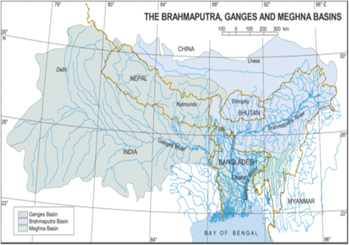
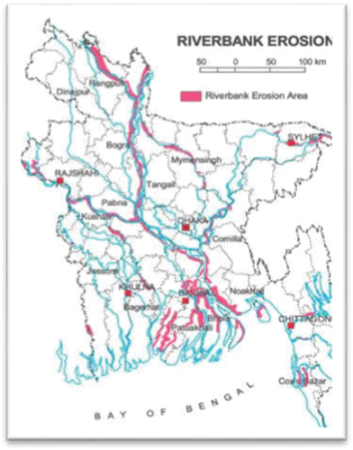
Figure 2. Riverbank-Erosion-Prone Areas in Bangladesh.
Geomorphologically, the mighty Padma River is still young. The channel pattern of this river is known as wandering as a result of multitude of meandering and braided category. The annual mean discharge and the bank full discharge of water from Padma River is 28,000 m3/sec and is about 75,000 m3/sec, respectively (RRI, Citation2001). The river Padma’s hydraulic actions are continuously shifting and transferring the shape of the river course, washing away its loose material and sandy bank intensely. Some sorts of variables (deforestation, huge quantity of rainfall, hydraulic geometry, siltation and channel migration) are highly responsible for eroding the Padma’s bank line (Malak et al., Citation2021; Rashid & Rahman, Citation2021; Uddin & Basak, Citation2012). In Faridpur District, 65 acres land in Decreer Char, 176 acres land in North Channel, 155 acres land in Char Harirampur and 107 acres land were eroded resulting from the bank erosion by the mighty Padma River (Ansari et al., Citation2001). A study has been conducted from Decreer Char Union to Gazirtek Union at Faridpur District, encompassed around 10 kilometers (km) along with the right bank of Padma River. A numerous important government and non-government institutions were destroyed and different homesteads property and agricultural lands were affected by subversive bank erosion of the Padma (RRI, Citation2001). This natural disaster has a long-term impact on lives and livelihood management of riverbank erosion victim households (REVHHs). A good portion of REVHHs have changed their occupation pattern due to loss of employment opportunities (Ghosh, Citation2016: Malak et al., Citation2021). After all, recent research pointed out that the impacts of riverbank erosion on lives and property in Bangladesh are higher than flooding (Rahman et al., Citation2014).
Objectives of the study
The study explores to demonstrate the nature of bank erosion in Charbhadrasan Upazila under Faridpur District along with the Padma River.
The focusing objectives of the study are as follows:
i) Estimating the erosion of spatial areas in the study area; and finally
ii) Illustrating the driving factors of erosion in Charbhadrasan Upazila that is along the bank line of the Padma.
Study area
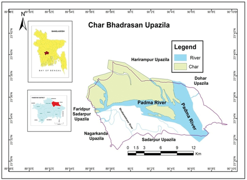
Charbhadrasan Upazila, Faridpur, is a riverbank-erosion-prone area in Bangladesh. Thus, this upazila is selected as the study area to carry on the work of estimating and investigating the causes of riverbank erosion by the Padma River. This river has eroded 10,132 households’ residence in Charbhadrasan Upazila since 1988–2013 and has led to displacement (Ghosh & Mahbub, Citation2014). In the study area, 37.5% displaces/erosion victims changed their occupation in accordance with the erosion of their income sources (Ghosh, Citation2016). In addition, Padma and Bhubaneshwar are the main rivers of Charbhadrasan Upazila as shown in . The collective flow of the Jamuna and Ganges that starts downstream Aricha, Manikgonj District, is known as the Padma River. The flow of this river goes forward southeastward and meets to the Meghna River. The Padma River extends approximately 100 km (CEGIS, Citation2014). The length, width and depth at Mawa, Munshigonj District, and catchment area of Padma River are 155 km, 5.71 km, 18.80 meter (m) and 1163 square kilometers (sq. km), respectively (BWDB, Citation2005). Bhubaneshwar River that is the distributary of Padma River crisscrosses on Charbhadrasan Upazila. The length, width, depth and catchment area of Bhubaneshwar River are 30 km, 20 m, 3 m and 150 sq. km, respectively (BWDB, Citation2005). There is no erosion at the bank of Bhubaneshwar River.
Figure 3. Study Area.
Data sources and methods of the study
This empirical study is based on different primary and secondary data sources. In this regard, the study belongs to primary data obtained by 304 sample surveys (3% REVHHs) and 8 Focus Group Discussions (FGDs). A semi-structured questionnaire is prepared to carry on this household sample survey. Household sample surveys were conducted by applying simple cluster random sampling technique. The secondary data are collected from Bangladesh Bureau of Statistics (BBS), Centre for Environment and Geographic Information Services (CEGIS), Local Government Engineering Department (LGED), Bangladesh Water Development Board (BWDB), River Research Institute (RRI) and different published research papers and documents.
In addition, Statistical Package for Social Sciences (SPSS) 17.0 and ArcGIS 10.1 software were used for data analysis and map production, respectively. For instance, SPSS 17.0 was applied for data processing and descriptive statistical analysis as well. Moreover, ArcGIS 10.1 software was used to digitize base map for delineation study area and to produce its map. Landsat satellite images from 1972 to 2014 of seven different time intervals were gathered from the United States Geological Survey (USGS) Earth Explorer. There was no uniform time interval for the selection of images in order to obtain cloud-free images. Therefore, the maximum and minimum intervals between the two selected images ( and ) are 10 year and 2 year, respectively. These selected images () were used to represent channel pattern of the Padma within Charbhadrasan Upazila and surrounding areas extracted through Erdas Imagine 2010 software. The band combination of the used extracted images is true colour composition (3, 2, 1).
Figure 4. Satellite Images of Study Area since 1972–2014.
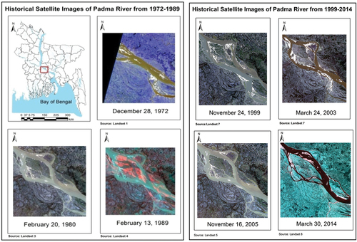
Table 1. Detailed information of the satellite images used in this study.
Results and discussion
Eroded spatial areas
This study records the eroded areas in Charbhadrasan Upazila since 1988–2013. Sixty-six villages are identified as eroded and partly eroded areas as shown in . Almost 50% eroded villages in Charbhadrasan Upazila were lost in 1998 as a result of severe flood. Entire Bangladesh faced a devastating flood in 1998 that inundated 68% of land of Bangladesh (Miah, Citation2004). Moreover, Charbhadrasan Upazila experienced sudden and gradual land erosion. This erosion is still continuing at some erosion-prone mouzas/villages of all unions in this upazila. Bank erosion of Padma becomes severe during flood resulting from huge volume and velocity of water in the meandering characterized river channel. The width of this river does not remain same at the all river course. The width of the river varied from 3.7 to 8.5 km during 1984 and from 2.7 to 10.7 km for the period 1984–93 at downstream of the confluence with the Jamuna at Baruria. The average width of the Padma River remained 5.7 km and 7.1 km in 1984 and 1993, respectively, considering left and right bank erosion rates were 121 m/year and 38 m/year at that years, respectively (EGIS, Citation2000).
Table 2. Eroded Village/Mouza in the study area.
shows erosion of settlement lands and roads from 2004 to 2013 in Charbhadrasan Upazila where maximum lands were eroded in 2004 by devastating flood. Overall, 95.4% erosion victims in the upazila have no own lands for building their houses due to erosion of the Padma River (Ghosh et al., Citation2017 & 2018). Land erosion vulnerability by mighty Padma River in the upazila is presented in .
Table 3. Land erosion of Charbhadrasan Upazila (2004–13).
Table 4. Erosion vulnerability assessment of Charbhadrasan Upazila (2005–13).
shows a numerous driving causes of erosion along right bank line of Padma River channel within Charbhadrasan Upazila and also other areas along the same bank line of this river. Basically, the major causes of bank erosion are fast river current, water pressure (volume of water), flood, char formation, channel shifting. These causes are also percied by local people () regarding bank erosion of the Padma River. Bank erosion occurs severely due to hydraulic action of flood water in river channel (Miah, Citation2004). During flooding, the bank lines become susceptible to erosion due to more energetic hydraulic mechanisms in the channel.
Table 5. Perceived causes of riverbank erosion.
Most of the villages of Charbhadrasan Union were eroded due to Padma River bank erosion in 1998 and 2002–04. The nature of the Padma River is a typical meander river that had maximum amount of erosion in 1995–2000 (Bhuiyan et al., Citation2017). Most of the villages of Char Harirampur Union were eroded in 1988 and 1998. Most of the villages of Gazirtek Union were eroded in 2000–05. Most of the villages of Char Jhaukanda Union were eroded in 1988 and 2009–13 as shown in . Therefore, the flood in 1998 is considered to have caused extreme bank erosion along the Padma bank line in Charbhadrasan Upazila.
Table 6. Most affected year of land erosion.
The bank materials are not uniform along both banks of the river in respect of erodibility. Bank materials at Paturia, from Dhulsunra to Mawa along left bank and at Sureshwar along right bank, consist of cohesive sediment that is less erodible. Other than these areas, bank materials of the Padma River consist of sand and silt, which are highly erodible. When the original flow of the Padma attacks cohesive sediment, the rate of maximum bank erosion is limited within a range of 0–20 m/year. In other places, the rate of maximum erosion is as high as several hundred meters per year (CEGIS, Citation2005).
Every year, the right bank of Padma River is shifting towards the right side (RRI, Citation2001). shows the historical satellite images of Padma River from 1972 to 2014. But the right bank erosion of Padma River is less in 2014 (). The right bank erosion of Padma River was high in 1998–99 and 2002–05 as shown in .
Water discharge during monsoon season is higher than that during other seasons at Baruria station which is situated near upper stream of the study area. Water discharges of August are 88,400 m3/sec and 105,858 m3/sec in 1988 and 1998, respectively, and water discharges of July in 2004 and September in 2010 is 944,352 m3/sec and 77,820.25 m3/sec, respectively (). Bank slumping, undercutting of bank and local scour from turbulence due to obstruction, char formation are the main causes of Padma riverbank erosion. The most affected years of erosion in Charbhadrasan Union, Char Harirampur Union, Gazirtek Union and Char Jhaukanda were 1998 and 2002–04, 1988 and 1998, 2002–05, and 1998, respectively, as shown in .
Table 7. Monthly average water discharge (m3/sec) at Baruria station.
Preventive measures of riverbank erosion
Erosion by stream flow is very common along the Padma River. Erosion control and management is a difficult and expensive task. Most of the local people (92.1%) prefer block embankment to prevent riverbank erosion because of the effectiveness shown in . Some people (21.7%) of the total respondents prefer river dragging to control bank erosion. Another group of people emphasized on channel cutting (40.5%) and tree plantation (29.9%) to protect bank line erosion. Generally, tree plantation along the bank line of river is the primary preventative measure in terms of bank erosion control.
Figure 5. Preventive Measures of Riverbank Erosion.
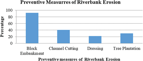
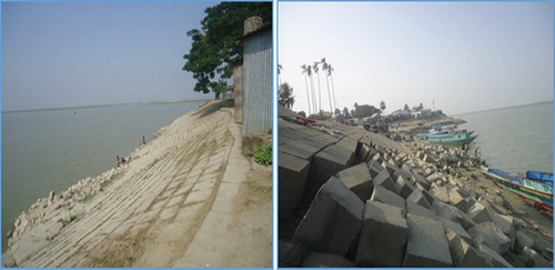
Figure 6. Block Embankment along Bank Line of Padma River in Study Area.
Conclusion
Riverbank erosion is a type of natural disaster that erodes lands and makes people displaced and shelterless. The land in Bangladesh along the GBM River systems is more vulnerable to bank erosion because of discharge of water, turbulence, char formation in the mid-channels and channels’ shifting and meandering character except the mighty Jamuna River. Charbhadrasan Upazila is one of the most affected and vulnerable upazilas in Bangladesh in terms of bank erosion. The people of this upazila became pauperized due to income erosion and being affected by bank erosion. Sixty-six villages in Charbhadrasan Upazila were eroded during 1988–2013 and the people of the villages were becoming marginalized because of the mighty Padma River bank erosion during 1988–2013. Block embankment is highly required to protect the bank line of Charbhadrasan Upazila from devastating bank erosion. This study suggests that channel dressing and monitoring are required to drive the water flow within the main channel of Padma River in order to protect the river bank. Another suggestion of the study depicts that the victim people of this upazila also meet the need of different facilities especially from govrnment to alleviate their poverty for leading happy lives.
Availability of data and materials
The dataset used and/or analyzed during the study is available from author’s field survey and mentioned institutions.
Supplemental Material
Download Zip (40.7 KB)Disclosure statement
No potential conflict of interest was reported by the author(s).
Supplementary material
Supplemental data for this article can be accessed online at https://doi.org/10.1080/21650020.2022.2123034
Additional information
Funding
References
- Ahmed, Q. K., Biswas, A. K., Rangachari, R., & Sainju, M. M. (Eds.). (2001). Ganges-Brahmaputra-Meghna Region: A Framework for Sustainable Development. The UNiversity Press Ltd.
- Aktar, M. N. (2015). Impact of Climate Change on River Bank Erosion. International Journal of Science, 7(1), 36–42.
- Ansari, M. N. A., Rahman, M. M., & Paul, S. (2001). Impact of riverbank erosion on Hunan: Case study of four unions in Faridpur District. Bhugol O Parivesh Journal (Geography and Environment Journal), 1 , 113–125.
- Bhuiyan, M. A. H., Islam, S. D. U., & Azam, G. (2017). Exploring impacts and livelihood vulnerability of riverbank erosion hazard among rural household along the River Padma of Bangladesh. Environmental System Research, 6(1), 25. https://doi.org/10.1186/s40068-017-0102-9
- Brown, O. (2008). Migration and climate change. IOM.
- BWDB. (2005). Rivers in Bangladesh (In Bangla). Bangladesh Water Development Board.
- CEGIS. (2005, September). Developing empirical methods for prediction morphology changes in the Padma River. In Jamuna-Meghna river Mitigation project. : Centre for Environmental and Geographic Information, 3–5.
- CEGIS. (2014). Erosion prediction 2014 for The Jamuna, The Ganges, The Padma and The lower Meghna River. Centre for Environmental and Geographic Information.
- EGIS. (2000). Riverine chars in Bangladesh: Environmental dynamics and management issues. In Environmental and geographic information services. and the University Press Limited, 24–48.
- Elahi, K. M. (1991). Impacts of Riverbank Erosion and Flood in Bangladesh: An Introduction. In K. M. Elahi, Q. S. Ahmed, & M. Mafizuddin (Eds.), Riverbank Erosion, Flood and Population Displacement in Bangladesh (pp. 1–9). REIS-JU.
- Ghosh, B. K. (2016). Riverbank erosion induced migrants’ livelihood pattern changes and management strategies: A case study of Charbhadrasan Upazila, Faridpur. Oriental Geographer, 60(1&2), 75–86. Printed in March 2019 http://geoenv.du.ac.bd
- Ghosh, B. K., & Mahbub, A. Q. M. (2014). Riverbank erosion induced migration: A case study of charbhadrasan Upazila, Faridpur. Oriental Geographer, 58(1), 59–71. Printed in July 2017 http://geoenv.du.ac.bd
- Ghosh, B. K., & Sarker, K. R. (2021). Climate change and living with floods: An empirical case from the Saghata union of Gaibandha District. In M. N. Md. Islam & A. V. Amstel (Eds.), Bangladesh, Bangladesh II: Climate change impacts, mitigation and adaptation in developing countries (pp. 459–478). Springer Cham.
- Islam, M. S., & Khatun, H. (2019). Riverbank erosion: A prolonged vulnerability threat. In H. Khatun, A. B. Baquee, & H. Kabir (Eds.), People at risk: Disaster and despair. Disaster Research and Training Management Centre (DRTMC) (pp. 231–252). University of Dhaka. https://doi.org/10.1007/978-3-030-71950-0
- Keya, M. K., & Harun, S. M. R. (2007). Riverbank erosion induced stress and coping of displaced women of Bangladesh. Empowerment, 14 , 17–30. http://www.students.clarku.edu/~sharun/Riverbank%20Erosion_Bangladesh.pdf
- Malak, M. A., Hossain, N. J., Quader, M. A., Akter, A., & Islam, M. N. (2021). Climate change-induced natural hazard: Population displacement, settlement relocation, and livelihood change due to riverbank erosion in Bangladesh. In M. N. Md. Islam & A. V. Amstel (Eds.), Bangladesh, Bangladesh II: Climate change impacts, mitigation and adaptation in developing countries (pp. 193–210). Springer Cham. https://doi.org/10.1007/978-3-030-71950-0
- Miah, M. M. (ed). (2004). Water management in Bangladesh: From vision to action. Bangladesh Water Partnership.
- Perch-Nielsen, S. L., Battig, M. B., & Imboden, D. (2008). Exploring the link between climate change and migration. Climatic Change, 91(3–4), 375. https://doi.org/10.1007/s10584-008-9416-y
- Rahman, M. A. T. M. T., Islam, S., & Rahman, S. H. (2014). Coping with flood and riverbank erosion caused by climate change using livelihood resources: A case study of Bangladesh. Climate and Development, 7(2), 185–191. https://doi.org/10.1080/17565529.2014.910163
- Rasheed, R. K. S. (2008). Bangladesh: resource and environmental profile. A H Development Publishing House.
- Rashid, H., & Rahman, M. K. (2021). Geographical perspectives on riverbank erosion, charlands, and floodplains. In Z. Mohammad & A. Mustafa (Eds.), Living on the edge char dwellers in Bangladesh (pp. 73–87). Springer Cham. https://doi.org/10.1007/978-3-030-73592-0
- Ghosh, B. K., Mahbub, A. Q. M. (20172018). Resettlement schemes of the riverbank erosion induced displacees: A case study of Charbhadrasan Upazila, Faridpur. Dhaka University Journal of Earth and Environmental Sciences, 6 & 7, 25–30.
- RRI. (2001). A study for the protection of Faridpur town and its adjacent areas from the erosion of Padma River. River Research Institute.
- Sarker, M. H., Hugue, I., Alam, M., & Koudstaul, R. (2003). Rivers, chars and char dwellers of Bangladesh. International Journal of River Basin Management, 1(1), 61–80. https://doi.org/10.1080/15715124.2003.9635193
- Tanjinul, H. M., & Jannatul, F. (2015). Riverbank Erosion, population migration and rural vulnerability in Bangladesh (a case study on Kazipur Upazila at Sirajgonj district). Environment and Ecology Research, 3(5), 125–131. https://doi.org/10.13189/eer.2015.030502
- Uddin, A. F. M. A., & Basak, J. K. (2012). Effects of riverbank erosion on livelihood. Unnayan Onneshan-The Innovators. http://www.unnayan.Org/…/Effect_of_Riverbank_Erosion_on_Livelihood.pdf
- Whitehead, P. G., Barbour, E., Futter, M. N., Sarkar, S., Rodda, H., Caesar, J., Butterfield, D., Jin, L., Sinha, R., Nicholls, R., & Salehin, M. (2015). Impacts of climate change and socio-economic scenarios on flow and water quality of the Ganges, Brahmaputra and Meghna (GBM) river systems: Low flow and flood statistics. Environmental Science: Processes & Impacts, 17(6), 1057–1069. https://doi.org/10.1039/C4EM00619D