Abstract
Along and across the border between the Spanish enclave of Ceuta and Morocco, cooperative and conflictual interactions, and a local amendment to the European Union external borders regime, have produced a multiplicity of everyday ‘atypical’ trade dynamics. These, in turn, have shaped the socio-spatial configurations of the enclave and, far beyond, of the neighbouring Tanger-Tetouan Region. Adopting the notion of ‘borderscapes’ as its main conceptual perspective, combined with research undertaken in Morocco, this article suggests that existing relational spaces and (informal) interactions can be catalysts for new perspectives of socio-spatial integration along and across the border, within the ‘cracks’ of current border regimes.
Introduction
This article examines the transcalar socio-spatial dynamics occurring at the Spanish–Moroccan borderlands. This case is of particular interest from a regional and an urban studies perspective, due to the peculiar conditions of Ceuta, a Spanish enclave in North Morocco, as one crucial section of the European Union external border in the Mediterranean. The disputed character of Ceuta, its special territorial status, the concurrent absence of formal institutional cooperation and the presence of de facto informal cooperative interactions at a local scale (Ferrer-Gallardo, Citation2010) are catalysts for a series of cross-border, atypical, trade activities (Castan-Pinos, Citation2008). The article investigates how far these trade dynamics have influenced the socio-spatial configurations of the enclave and neighbouring territories in the Tanger-Tetouan Region.
The mutual processes of ‘shaping’ between political boundaries, power relations, local/transnational human mobilities and everyday border experiences are explored through the conceptual lens of the borderscapes notion (Brambilla, Citation2014; Rajaram & Grundy-Warr, Citation2007). Often referred to Appadurai’s (Citation1996) ‘-scapes’ theory, this innovative perspective has been employed with manifold connotations in different academic fields. In spatial and normative terms, borderscapes are seen as ‘solidifications’ of political ideas resulting from both natural or human delimitations, and differences in neighbouring planning systems (Harbers, Citation2003). On the other side, this approach allows one to look at borders as multidimensional and mobile ‘social constructs and processes’ (Paasi, Citation2005, p. 19), stressing the coexistence of multiple landscapes of power and alternative relational landscapes of encounters, ‘negotiations, claims, and counterclaims’ (Rajaram & Grundy-Warr, Citation2007, p. xxx).
Due to its polysemic character (Brambilla, Citation2014), the borderscapes notion suggests reading the Ceuta–Morocco borderlands beyond the borderline itself (Brambilla, Citation2014), into broader territorial fields, and outside existing polarized representations and ambivalent Euro-Mediterranean border policies (Bialasiewicz, Giaccaria, Jones, & Minca, Citation2012; Celata & Coletti, Citation2013). The gated community metaphor (Castan-Pinos, Citation2008; van Houtum & Pijpers, Citation2005) analyses the enclave as one crucial ‘gate’ of the European Union’s external border regime, where a selective and permeable border system allows and hinders different human and commercial flows (Castan-Pinos, Citation2008).
The case study uses direct observations, archive work and interviews with local actors to explore the socio-spatial dynamics of Ceuta within this conceptual scenario.
The Spanish–Moroccan borderscapes
The Spanish–Moroccan borders represent a multiform territorial complex (Ferrer-Gallardo, Citation2008): a sea border at the Strait of Gibraltar and the Canary Islands; and a land border along the perimeters of the ‘Spanish autonomous cities’ of Ceuta and Melilla and the plazas de soberania.Footnote1 These are the last leftovers of Spanish rule in North Africa following Moroccan independence (1956) and the end of the Spanish Protectorate (1912–56). Considered by Spain as part of its national territory for historical, political and legal reasons, Ceuta, Melilla and the plazas have never been officially recognized by the Moroccan government, with consequent territorial disputes (Andalucía Libre, Citation2002).
Since the mid-1990s, following Spain’s admission to the European Union (1986) and the Schengen Agreement (1991), Ceuta and Melilla’s border perimeters started to be sealed off (Ferrer-Gallardo, Citation2008) in compliance with European Union migration concerns and policies. Furthermore, in 1999 a high-tech integrated system of external border control (Sistema Integrado de Vigilancia Exterior – SIVE) was set up on the Andalusian coast and, later, in the Canary Islands. Due to the SIVE and the resulting blockage of migratory routes through the Mediterranean, the enclaves became prominent migration focuses. The situation culminated in the events of September 2005, when 11 migrants died and many others were injured attempting to cross the fences (Ferrer-Gallardo & Albet-Mas, Citation2013). More recently, in February 2014, 15 Sub-Saharan migrants drowned in Spanish–Moroccan waters while trying to circumnavigate Ceuta’s barrier, under conditions and responsibilities yet to be explained.
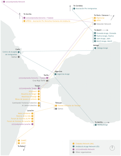
Here the coexistence between dominant landscapes of power (Rajaram & Grundy-Warr, Citation2007) and resulting strategies of border resistance (Brambilla, Citation2014) becomes evident. The latter, in particular, draw on a multiplicity of relational networks of civil society organizations across the Strait of Gibraltar, concerned with migrants’ rights and supporting ‘border communities’. Figure shows, among others, Chabaka Network (http://www.chabaka2000.wordpress.com), APDHA (http://www.apdha.org) and Andalucía Acoge (http://www.acoge.org). These ‘relational landscapes’ consist of different social and cultural ties at the local/regional scale, as well as at the European level, defining other geographies of inclusion and encounter.
Figure 1. ‘Border resistance’ networks across the Strait of Gibraltar.

On the institutional side, the maintenance of good partnerships on migratory issues and economic cooperation has been a strategic priority for both countries through the signature of bilateral agreements within the framework of European Union programmes. Among many others, these include the Euro-Med Partnership, INTERREG (e.g., IIA Spain–Morocco 1994–1999; IIIA Spain–Morocco 2000–2006) and the European Fund for Regional Development (Programa Operativo España Fronteras Exteriores 2008–2013 – POCTEFEX).
While Spanish–Moroccan institutional relations have increasingly improved on national and regional issues, the peculiar political conditions of the enclaves have hindered formal cross-border dialogue between local institutions (Ferrer-Gallardo, Citation2010), due to the persistence of sovereignty disputes.
In turn, this lack of ‘official’ collaboration has allowed a multiplicity of de facto trans-boundary trade practices. Indeed, according to a 2002 report of the American Chamber of Commerce of Casablanca (quoted in APDHA et al., Citation2012), around 45,000 people in Ceuta and Melilla depend directly on informal trade and 400,000 are indirectly involved in this kind of activity. In 2005, a journalistic investigation estimated that up to 80% of the goods received by Ceuta and Melilla from Spain directly flowed towards Morocco through the cities’ perimeters, in large part irregularly (Barbulo, Citation2005).
The following section is dedicated to outlining and examining the socio-spatial effects of these practices of (commercial) interaction at the Ceuta–Morocco borderscapes.
Informal trade practices between Ceuta and Morocco: cross-scalar socio-spatial effects
Ceuta is located on the south-eastern peninsula of the Strait of Gibraltar, 65 km east of Tanger (known in English as Tangiers). It occupies 19.6 km2 (Ciudad de Ceuta, Citation2008), with a population of 84,180 inhabitants (Instituto National de Estadistica (INE), Citation2013) and a density of 4,294 inhabitants/km2.
The 1987 Census estimated that around 21% of the residents were Muslim (Planet, Citation1996). However, the demographic composition of the enclave appears to be far more complex, due to the presence of a mobile population of around 25,000 Moroccan citizens (El Abdellaoui & Chikhi, Citation2013) entering Ceuta on a daily basis for work purposes. In fact, the Protocol of Accession of Spain attached to the Schengen Agreement ‘stated that the citizens from the Moroccan provinces adjacent to Ceuta (Tetouan) and Melilla (Nador) are exempted from visa requirements’ (Castan-Pinos, Citation2008, p. 15). These everyday practices of border crossing are made possible as a result of the ‘selective permeability’ of the border and the historical and ongoing interdependencies between the enclave and its Moroccan hinterland (Castan-Pinos, Citation2008).
In 1993, the border between Ceuta and Morocco started to be enclosed by an 8 km-long militarized barrier, further enhanced in 1999 with a technologically equipped 2.1 m-high double fence (valla) in order to prevent irregular crossings and cross-border ‘smuggling’ activities.
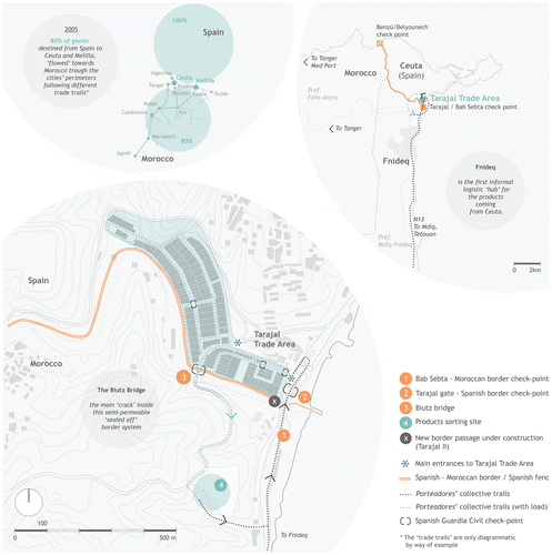
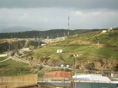
The main official border checkpoints used to be located at the two extremes of the fence: the Tarajal/Bab Sebta gate and the Benzú/Belyounech passage, which was closed in 2004. In 2005 another border passage, the Biutz bridge, was opened in the fence in order to decrease the pressure on the existing crossing. The bridge is placed directly inside the Tarajal trade area (Figure ), a large commercial site, contiguous to the Tarajal/Bab Sebta border checkpoint. This area opened in 1995, in the broader framework of the political and economical international challenges taken up by Spain in light of the increasing role of Morocco in the World Trade Organisation (WTO) and the acquired autonomous status of Ceuta and Melilla (1995). In this context, the Biutz bridge (Figure ) represents the main ‘crack’ inside this semi-permeable ‘sealed off’ (Ferrer-Gallardo, Citation2008) border system, as a point of high concentration of a series of cross-scalar border dynamics, the origins and outcomes of which are related to broader territorial and political fields, beyond the enclave and the border itself.
Figure 2. Informal trade dynamics at the Spanish–Moroccan borderscapes.

As a consequence of the exemption from visa requirements, from Monday to Thursday, from 8.00 am to 1.00 pm,Footnote2 the porteadores (literally ‘carriers’, and mainly women of all ages) can enter the Tarajal trade area through the Tarajal/Bab Sebta frontier post. Inside they buy a variable amount of daily use, food and technological goods and transport them to Morocco on their shoulders, exiting directly through the Biutz, and restart their circular trail from Bab Sebta. The products are eventually sold outside the city’s perimeter and introduced into Moroccan trade circuits (Figures and ).
Figure 3. Porteadores’ trails and products sorting sites outside the Biutz Bridge.

Moreover, due to the absence of an official customs checkpoint, goods are not subject to any taxation: the carriers can pass the products through the Biutz bridge as personal belongings and sell them in Morocco at a cheaper price. Due to local and regional economic interdependences (Castan-Pinos, Citation2008) and to the lack of a formal framework, a kind of unwritten trade-off between local traders and border patrols, at a local scale, allows an estimated flow of goods worth around €6 million each day (El Abdellaoui & Chikhi, Citation2013).
The circular daily migrations of the porteadores produce direct and indirect cross-scalar effects on the economy and the urban development of the enclave, the bordering municipalities (Fnideq and Taghramt) and the villages (Belyounech) of the Prefectures of Fnideq-M’diq and Fahs-Anjra.
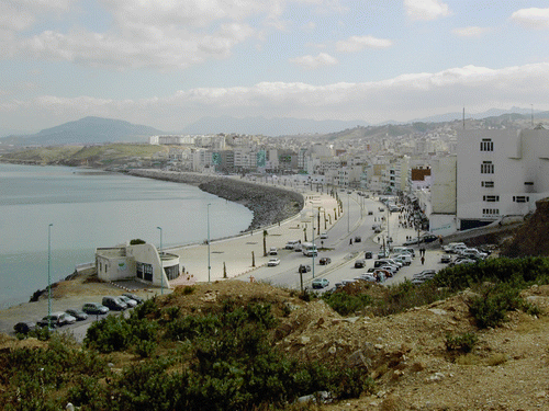
The small town of Fnideq (Castillejos), located 4 km south of Ceuta is the main example of the outcomes of border dynamics. Its economic, demographic and urban landscapes have been shaped by the trade activities described (Figures and ). Available data show that the 36% of Fnideq’s active population is employed in commercial activities, while the main markets of the town are devoted to products coming from Ceuta (El Abdellaoui & Chikhi, Citation2013). According to both interviews undertaken locally and data collected in the area, most activities and settlements (e.g. farming, small real estate investments and informal housing) along the Ceuta–Fnideq–Tetouan littoral and its immediate inlands are related to the border economy.
Figure 4. Fnideq’s urban landscape, 2007.

The N13 route (Figure ) represents the main axis of movement for the porteadores and the products. Beyond local daily mobilities, a series of broader internal migration processes from the rural areas and other urban centres towards Ceuta’s surroundings and the littoral have also occurred (El Abdellaoui & Chikhi, Citation2013).
Alongside these dynamics, some other and opposite signs of change are emerging in the region. Some recent studies have shifted attention to the progressive decay of the relevance of illegal trade due to ‘the gradual commercial de-bordering between the EU and Morocco [… and] substantial investment and infrastructural transformations taking place in the north of Morocco’ (Ferrer-Gallardo, Citation2010, p. 29), such as the implementation of the Tanger-Med international harbour (second stage) and of free industrial and trade zones (e.g. Renault Tanger-Mellousa plant).
Moreover the recent ongoing construction of an alternative to the Biutz bridge on the Spanish side, the Tarajal II, and the announced forthcoming renovation of the Tarajal border and its surroundings (Europa Press, Citation2014) have been accompanied, on the Moroccan side, by a process of redesign of the Bab Sebta border checkpoint. These public works are signals of de facto relations between local administrative governments about small-scale urban interventions. Other emerging signals include the rise of local non-governmental organizations concerned with cross-border economic and social development (El Faro Digital, Citation2012).
Conclusions: which levers of changes work towards a cross-scalar urban agenda?
This study of the Ceuta–Morocco borderscapes has shown how unofficial cross-border collaborative interactions among different (non)institutional subjects are made possible due to the peculiar conditions of Ceuta as one ‘fracture’ inside the Schengen border regime.
By stressing the plurality of relational cross-scalar resources already stratified at the Ceuta–Morocco borderlands, the borderscapes notion allows for rethinking and opening new perspectives of socio-spatial integration for these borderlands into a multiplicity of other territorial fields.
Thus, it is worth asking which ‘levers’ are needed in order to catalyse converging interests across different administrative regimes, to enhance forms of equal and mutual development for border communities, and to ensure them access to primary services, safer housing and work conditions.
One possible lever to consider is the role of third-sector and civil society organizations and their cross-scalar networks. In order to depolarize existing territorial discontinuities (Ferrer-Gallardo, Citation2010), these organizations could contribute, through their practices, to the enhancement of cultural, social and visual continuities (Ferrer-Gallardo, Citation2010) across and along the border. This could be achieved by reorienting actual trans-border practices as resources for local development initiatives and by negotiating exceptional amendments to local regulations.
A second lever addresses the cross-scalar urban agenda through the integration of multilevel territorial governance in the Tanger-Tetouan Region and ‘surgical’ urban planning interventions: reorganizing mobility micro-infrastructures and facilities for cross-border communities at different scales; rethinking the localization of trade corridors and markets in relation to local/transnational populations’ needs and regional trade/industrial dynamics; supporting self-managed social ventures; identifying mechanisms of renovation or adaptation of existing informal settlements in light of macro-regional demographic dynamics (e.g. input/output and internal migration flows), bypassing ex novo-based national housing programs and initiatives.
Adopting such a cross-scalar and multidimensional approach in other areas, drawing on the borderscapes approach, could thus suggest new perspectives on Euro-Mediterranean ‘polarized’ border policies, and on current and consolidated cross-border regional programmes, leading towards a reconsideration of border regions outside given territorial ‘containers’, and beyond borders themselves.
Acknowledgements
The evidence presented in this paper draws on three research missions: in March 2009 to Ceuta (directed by Anna Nufrio); and in October 2013 and February 2014 to the Tanger-Tetouan Region. The latter were made possible thanks to the scientific support and supervision of Abel Albet-Mas, Xavier Ferrer-Gallardo and Keina Espiñeira (UAB, Barcelona) and Nour Eddine Chikhi (Université Abdelmalek Essaâdi, Tetouan). The author is sincerely grateful to all of them. Thanks too to Chiara Brambilla (University of Bergamo) for orienting the research with her inspiring work on the borderscapes perspective. Thanks also to Beatrix Haselsberger and Paul Braidford (RSA) for their support.
Notes
1. A series of small archipelagos (Chafarinas Islands, Alhucemas Islands) and peninsulas (Peñón de Vélez de la Gomera, Peñón de Alhucemas), located on the Northern Moroccan coast.
2. Ceuta’s local Government defines the opening hours of Biutz bridge.
References
- Andalucía Libre (2002). Colonias de Ceuta y Melilla – Polémica ( Libre buletin No. 116). Andalucía Libre. Retrieved from http://elistas.egrupos.net/lista/andalucialibre/archivo/indice/91/msg/134/
- APDHA, Asociación Pateras de la Vida, APDHMl, Red Chabacka, CEAR, ... Association Almunadila. (2012). Declaration of Tetouan on Carrier Women at Ceuta and Melilla Borders. Retrieved from AEDH http://www.aedh.eu
- Appadurai, A. (1996). Modernity At Large: Cultural Dimensions of Globalization. Minneapolis, MN: University of Minnesota Press.
- Barbulo, T. (2005, October 9). Ceuta recela del futuro. El País. Retrieved from http://elpais.com/diario/2005/10/09/domingo/1128829293_850215.html/
- Bialasiewicz, L., Giaccaria, P., Jones, A. & Minca, C. (2012). Re-scaling ‘EU’rope: EU macro-regional fantasies in the Mediterranean. European Urban and Regional Studies, 20(1), 59–76. doi:10.1177/0969776412463372.
- Brambilla, C. (2014). Exploring the critical potential of the borderscapes concept. Geopolitics (online first). doi:10.1080/14650045.2014.884561.
- Castan-Pinos, J. (2008). Building Fortress Europe? Schengen and the Cases of Ceuta and Melilla ( CIBR/WP18. CIBR Working Articles in Border Studies). Retrieved from CIBR http://www.qub.ac.uk/
- Celata, F., & Coletti, R. (2013). Cross-border cooperation in the Euro-Mediterranean and beyond: between policy transfers and regional adaptations. International Journal of Euro-Mediterranean Studies, 5, 109–120. doi:10.1007/s40321-013-0006-z.
- Ciudad de Ceuta (2008). Revisión y adaptación del Plan general de ordenación urbana. Avance de planeamiento. Retrieved from http://www.ceuta.es/pgou/paginas/documentos.html/
- El Abdellaoui, M., & Chikhi, N. (2013). Dinámica de los espacios fronterizos con Ceuta (Estudio Geográfico). Ceuta: Instituto de Estudios Ceutíes.
- El Faro Digital (2012, March 25). Perseguimos favorecer a Ceuta en materia social y económica. El Faro Digital. Retrieved from http://elfarodigital.es/ceuta/sociedad/91217-perseguimos-favorecer-a-ceuta-en-materia-social-y-economica-.html/
- Europa Press (2014, 22 July). Interior iniciará las obras de remodelación de la frontera ceutí del Tarajal a finales de 2015 o principios de 2016. Europa Press. Retrieved from http://www.europapress.es/nacional/noticia-interior-iniciara-obras-remodelacion-frontera-ceuti-tarajal-finales-2015-principios-2016-20140722145434.html/
- Ferrer-Gallardo, X. (2008). The Spanish-Moroccan border complex: processes of geopolitical, functional and symbolic rebordering. Political Geography, 27, 301–321. doi:10.1016/j.polgeo.2007.12.004.
- Ferrer-Gallardo, X. (2010). Territorial (dis)continuity dynamics between Ceuta and Morocco: conflictual fortification vis-à-vis co-operative interaction at the EU border in Africa. Tijdschrift voor Economische en Sociale Geografie, 102(1), 24–38. doi:10.1111/j.1467-9663.2009.00575.x.
- Ferrer-Gallardo, X., & Albet-Mas, A. (2013). EU-limboscapes: Ceuta and the proliferation of migrant detention spaces across the European Union. European Urban and Regional Studies, 20(4), 1–4. doi:10.1177/0969776413508766.
- Harbers, A. (2003). Borderscapes: the influence of national borders on spatial planning. In R. Broesi, P. Jannink, & W. Veldhuis (Eds.), Euroscapes (pp. 143–166). Rotterdam: MUST Publ. AetA.
- Instituto National de Estadistica (INE) (2013). Series de población desde 1996. Cifras oficiales de la Revisión anual del Padrón municipal a 1 de enero de cada año. Retrieved from http://www.ine.es/
- Paasi, A. (2005). The changing discourses on political boundaries. Mapping the backgrounds, contexts and contents. In H. van Houtum, O. T. Kramsch. & W. Zierhofer (Eds.), B/ordering Space (pp. 17–31). London: Ashgate.
- Planet, I. (1996). Ceuta y las migraciones marroquíes. In B. López García (Ed.), Atlas de la inmigración magrebí en España. Atlas 1996. Madrid: TEIM.
- Rajaram, P. K., & C. Grundy-Warr. (2007). Introduction. In P. K. Rajaram, & C. Grundy-Warr (Eds.), Borderscapes: Hidden Geographies and Politics at Territory’s Edge (pp. ix–1). Minneapolis, MN: University of Minnesota Press.
- Van Houtum, H., & R. Pijpers. (2005). Towards a gated community. Eurozine. Retrieved from http://www.eurozine.com/articles/2005-01-12-houtumpijpers-en.html/
