
Abstract
Household energy use is of relevance for studies of sustainability and fuel poverty. Detailed mapping and spatial analysis is possible in the UK due to the release of fine-scale household energy-use data. The cartographical approach used here focuses on urban energy use and the relative performance of urban areas in England and Wales. The energy-use data were transformed to a 1 km2 grid of cells allowing consistent comparisons to be made between urban areas at the same zonal scale. Additionally cells were extruded according to population density, highlighting basic relationships between density and energy use. The urban perspective on energy use is important due to the strong influence of the built environment in determining energy efficiency, and furthermore due to the clustering of affluent and deprived social groups in cities. The results of the mapping highlight how the lowest and the highest energy-use districts are located within the same city-regions, and how further variations in energy use relate to housing density and energy-efficiency behaviours.
Method
A recent innovation from the UK government has been to increase the spatial resolution of household energy consumption data to Lower Layer Super Output Area (LSOA) scale (DECC, Citation2014a), enabling more detailed mapping. Note that a number of assumptions are made in the production of these data (DECC, Citation2014b). For this analysis, gas and electricity use have been combined into a total household energy measure.
Standard UK energy use maps (e.g., ONS, Citation2013) suffer from the limitations of choropleth mapping (Dorling, Citation1993): namely the visual prominence given to large rural zones of low population, and the restricted legibility of urban areas. As an alternative approach, the data here have been transformed to a 1 km2 grid (using a spatial join based on areal proportion). This technique assumes that the households within each zone are evenly distributed across space. In urban areas the LSOA zones are smaller than the 1 km2 grid squares, and these assumptions have little effect. In rural areas, where census zones increase significantly in size, the grid technique is not appropriate. Consequently a threshold of 1000 residents per km2 has been applied, and the map is not suitable for understanding patterns in rural areas.
As a final step, the grid cells have been extruded in three-dimensions (3D) according to the population density in each cell. The reasons for doing this is, firstly, to give greater visual prominence to areas where more people live and, secondly, to provide a visual indication of relationships between density and energy use.
Results
The household energy consumption map (Figure ) clearly displays the two primary drivers of household energy use: housing type and affluence. Major cities are characterized by a high-density core of lower energy consumption, averaging less than 15,000 kWh per household compared with city-wide averages of around 18,000 kWh for London, Manchester and the West Midlands. This density trend can also be seen in the efficient performance of higher density cities, such as Brighton (15,750 kWh city average), Bristol (16,000 kWh) and Liverpool (16,500 kWh).
Figure 1. Household domestic energy consumption estimates in England and Wales, 2012, at the scale of 1 km2 grid cells. Cell heights show population density in 2011; densities below 10 residents per hectare are excluded. The map is available in interactive form at: http://luminocity3d.org/.
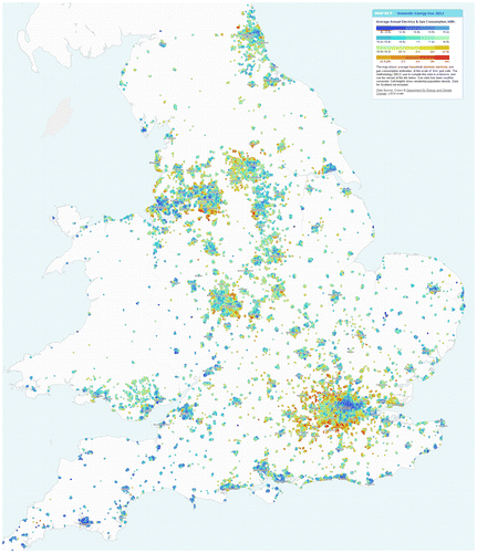
The areas of lower consumption contrast strongly with affluent suburban areas, where average consumption is above 27,000 kWh. This wealth relationship is most clearly seen in Greater London in the stark difference between east and west. The towns with the highest energy use in England and Wales (above 20,000 kWh) are in the commuter belt of London. Similar trends of high-consumption suburbs are also visible in South Manchester, North Leeds and West Sheffield. In addition to the built-environment factors of large detached housing, there is also a significant behavioural element in the wealth–energy relationship. Richer households can generally afford to be more profligate in their heating and appliance use (Druckman & Jackson, Citation2008).
By far the most efficient region in England and Wales is the South West, where cities such as Plymouth and Exeter have the lowest average consumption figures of around 14,000 kWh. As well as being the influence of the milder climate, this could reflect positive behavioural measures in a region renowned for green industries.
Acknowledgements
Energy-use data are Crown © Department for Energy and Climate Change. Population data 2011 Census are Crown © Office for National Statistics. Boundary data are Crown © Ordnance Survey.
Additional information
Funding
Related Research Data
References
- Department for Energy and Climate Change. (2014a). Sub-National Energy Consumption Statistics: LLSOA electricity and gas 2012. London: Author. Retrieved from gov.uk: https://www.gov.uk/government/statistics/llsoa-electricity-and-gas-2012-experimental
- Department for Energy and Climate Change. (2014b). Sub-national consumption statistics: Methodology and guidance booklet. London: Author. Retrieved from gov.uk: https://www.gov.uk/government/statistics/regional-energy-data-guidance-note
- Dorling, D. (1993). Map design for census mapping. The Cartographic Journal, 30, 167–183.10.1179/caj.1993.30.2.167
- Druckman, A., & Jackson, T. (2008). Household energy consumption in the UK: A highly geographically and socio-economically disaggregated model. Energy Policy, 36, 3177–3192.10.1016/j.enpol.2008.03.021
- Office for National Statistics. (2013). Household energy consumption in England and Wales, 2005–11. London: Author. Retrieved from Office for National Statistics. http://www.ons.gov.uk/ons/dcp171766_321960.pdf