
Abstract
A key factor in understanding a city-region is the daily flows of people between its constituent parts. Mapping of the commuter field may help delineate the functional extent of the region, clarify challenges of transport efficiency, access and affordability, and reveal the impact of key transport interventions over time. It may also elucidate social dimensions of life in the region, notably patterns of inequality between groups. Data from the Gauteng City-Region Observatory’s (GCRO) 2013 Quality of Life Survey were used to map trips to work made by white and (separately) African respondents. The maps illustrate the functional extent of the city-region as well as ongoing racial disparities in geographic access-to-work opportunities in a region historically patterned by apartheid spatial forms. While there is significant continuity from the past, there are also some surprising new trends.
A key factor in understanding a city-region is the daily flows of people between its constituent parts. Traffic flows are often mapped to depict a ‘commuter field’, which may be taken as a delineation of a functional city-region (Manley, Citation2014; Organisation for Economic Co-operation and Development (OECD), Citation2011). Mapping of commuters’ daily trips may graphically illustrate challenges with the efficiency, accessibility and affordability of a region’s transport networks. Iterations of the same maps over time may reveal the impact of key transport interventions such as new connector roads or public transit operations. In addition, transport mapping may elucidate social dynamics, notably dimensions of everyday life and patterns of inequality between groups.
We present two maps of the flows of trips to work across the Gauteng City-Region (GCR) in South Africa, one for ‘whites’ and the other for ‘Africans’ (see Figures and ). The maps are derived from the Gauteng City-Region Observatory’s 2013 Quality of Life Survey. Run every two years, this representative household survey asks respondents – whose home location is captured with global positioning satellite (GPS) coordinates – to provide details of their most frequent trip, including the purpose, time taken and destination. A straight line plotting of movement from exact home origins to the centroid of destination suburbs has been done for each respondent who made a trip to work – 6741 in all of 27,490 respondents in the 2013 survey. The origin to destination plots appear against a backdrop of urban land cover.
Figure 1. Trips to work by African respondents.
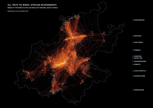
Figure 2. Trips to work by white respondents.
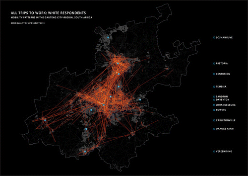
Together the maps are indicative of the spatial extent and form of this sprawled region of some 13 million people. Viewed separately they reveal continued social divisions inherited from apartheid. Trips made by white respondents (1048 trips) concentrate at the centre of the city-region, while those by African respondents (5423 trips) originate from a much wider area on the periphery.
Surprisingly, despite these differences, the average (mean) straight line distances travelled to work were the same for both groups (14 km). This reflects an unexpected distribution of local and longer distance trips. A greater percentage of white respondents have shorter trips to work (less than 25 km) than African respondents, many of whom travel long distances from areas on the fringe of the GCR such as Soshanguve, Orange Farm and Daveyton. However, remarkably, a larger percentage of white respondents travel more than 25 km to work than African respondents, equalising the two averages. The difference may be explained by a number of factors, including the greater proportional access that typically wealthier white residents have to private vehicles, enabling them to travel longer distances to work across the region, as well as the massive development of new gated housing estates and townhouse developments on the urban edge to which the middle-classes are retreating.
While the mean distance travelled is the same between whites and Africans, the average duration of work trips still shows racial differentiations. On average African respondents travel 56 min to work compared with 42 min for white respondents. African respondents consequently also start their daily journey to work much earlier in the day – 25% before 6 a.m. compared with just 5% of white respondents. These racially differentiated trip start and travel times still mirror the apartheid patterns captured in transport surveys carried out in the 1970s (TPARD, Citation1980).
Data sources
Gauteng City-Region Observatory: 2013 Quality of Life survey; GeoTerraImage: 10 m land cover (© 2010). The underlying research materials for this article (2013 Quality of Life Survey data) can be accessed at http://www.gcro.ac.za/qolviewer.
Acknowledgements
Gauteng City-Region Observatory is a partnership between the University of Johannesburg, the University of the Witwatersrand, Johannesburg, and Gauteng Provincial Government.
Disclosure statement
No potential conflict of interest was reported by the authors.
References
- Manley, E. (2014). Identifying functional urban regions within traffic flow. Regional Studies, Regional Science , 1 , 40–42.10.1080/21681376.2014.891649
- Organisation for Economic Co-operation and Development (OECD) . (2011). The Gauteng City-Region, South Africa 2011. OECD Territorial Reviews . Paris: Author. http://dx.doi.org/10.1787/9789264122840-en
- Transvaal Provincial Administration Roads Department (TPARD) . (1980). PWV transportation study: Final report ( Volume 1 – Data collection and base-year data). Pretoria: Author.