
ABSTRACT
As a result of growing food demands, the area of land used globally for agriculture has rapidly increased over the last 300 years. Clearance of natural vegetation and conversion of land to agriculture is often associated with terrestrial carbon loss, from both vegetation and soil stores. Changes in terrestrial carbon storage has implications for food production, climate and water regulation. Quantifying these changes is therefore vital to understand the risks to and resilience of these benefits. Land use in the East of England has significantly changed during this period and is now predominantly used for agriculture, specifically arable use. In order to map changes to terrestrial carbon storage in this region since 1700, we apply a plant–soil system biogeochemistry model, N14CP. The model indicates carbon storage in the East of England has decreased by 109 Mt (−35.7%) during the study period, and whilst losses are observed in both soil and vegetation stores, vegetation losses as a result of forest clearance dominate. These findings have implications for carbon sequestration strategies; the largest carbon storage gains within the region are likely to be achieved through land-use transitions such as afforestation, rather than soil sequestration through changing arable management practices.
Due to population growth and increasing food demands, agricultural land has expanded rapidly over the last 300 years, resulting in the depletion of terrestrial organic carbon stores. In addition to the loss of carbon stored within biomass through the clearance of natural vegetation, agricultural land management practices have been noted to reduce soil organic carbon (Deng et al., Citation2016). Terrestrial carbon stores are linked to a range of ecosystem services, notably climate regulation, food production and water regulation (Adhikari & Hartemink, Citation2016). Therefore, loss of carbon from these stores has significant implications for society, including food security issues, increased flood/drought risk and the exacerbation of climate change. The importance of sustainable soil and land management for reducing environmental degradation has been recognized both internationally (IPCC, Citation2019) and within the UK; the 25-year environment plan states England’s soils must be managed sustainably by 2030. International carbon sequestration initiatives such as ‘4 per mille’ (Minasny et al., Citation2017) acknowledge the climate mitigation potential of soils.
The East of England region covers an area of 19,150 km2, with the majority of land used for agriculture (currently approximately 79%), partly due to its low-lying fertile soils and flat landscapes. Since 1700, the region has seen a significant expansion of agriculture, with arable and improved grassland increasing by approximately 520% and 220%, respectively. The region therefore presents an interesting and important case to investigate how terrestrial carbon storage has changed due to agricultural expansion.
In this study we use plant–soil system biogeochemical model to estimate these changes. Previous studies have noted the need to integrate carbon, nitrogen and phosphorus (C, N, P) cycling within these models due to linkages and interdependencies between the cycling of these elements (Achat et al., Citation2016). Here we apply a novel model of C-N-P cycling, N14CP, that includes representation of both natural and agricultural land uses and associated land management options (Janes-Bassett et al., Citation2020), hence enabling the impacts of land-use transitions on terrestrial carbon storage to be quantified. The N14CP model was applied across the East of England using a 5 × 5 km grid. Regional application is feasible due to the lack of site-specific calibration and use of readily available input data (for full details of the datasets used, see Janes-Bassett et al., Citation2021). We apply the N14CP model from the period 1700–2020, enabling the impacts of anthropogenic changes on terrestrial carbon storage since before the Industrial Revolution to be estimated across the region. The model was compared against regional data; Natmap carbon and Countryside Survey data (Cranfield University, Citation2020; Henrys et al., Citation2012) with average simulated topsoil carbon deviating by −1.96% to −17.76% (see the supplemental data online).
The model output indicates an overall loss of total C within the region of 109 Mt (−35.7%) ((d)). This is made up of losses to soil C (14 Mt, −14.7%) and biomass stores (95 Mt, −66%). However, as shown in , there is significant spatial variation across the region, with some areas indicating small gains in soil and/or vegetation C stores largely due to the type of land-use change that has occurred. For example, (a) indicates areas of arable expansion broadly correspond to losses in soil C ((b)). This is to be expected due to the removal of C (through harvesting), reduced inputs into the soil system and adoption of tillage practices (increasing decomposition rates and C loss). The variation in magnitude of soil C losses across areas of arable expansion is due to prior land use; in 1700, this area was made up of a mix of rough grassland, heath, fen marsh and forest (6%, 20%, 49% and 25% respectively). The model indicates land that was heath prior to conversion shows the greatest C loss over the study period, averaging −18 t C ha−1 compared with −5 t C ha−1 for other land uses. This is due to the greater initial soil C stored in land classed as heath prior to conversion (78 t C ha−1 in heath compared with 42–53 t C ha−1 in other land uses).
Figure 1. Change in terrestrial organic carbon storage from 1700 to 2020 in the East of England as simulated by the N14CP model.
Note: (a) Land-use change; (b) topsoil carbon change (kt); (c) vegetation carbon change (kt); and (d) total terrestrial organic carbon change (kt). Line graphs show the distribution of data for 1700 and 2020.
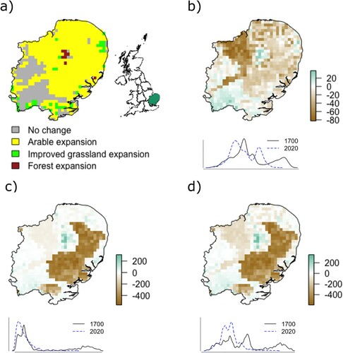
A small area of forest expansion during the 1900s (a result of the UK Forestry Act) corresponds with increasing soil C as a result of increased litter inputs into the soil organic matter pool. The increased vegetation C in these areas is partly due to increasing tree growth as these forests reach maturity, but also due to effects of atmospheric deposition of N resulting in an increase of net primary productivity in these systems, which in turn increases litterfall and soil organic matter (Tipping et al., Citation2017). The largest losses in vegetation C storage observed in (c) correspond with an area of forest that was cleared for arable land use, which equates to a C loss of 134 Mt.
The results indicate that since 1700, the East of England is dominated by carbon losses directly resulting from agricultural expansion. Whilst the N14CP model highlights significant losses from soil organic carbon pools, the majority of carbon loss is due to the removal of natural vegetation. This result contrasts with the net terrestrial carbon gain observed across the UK as a whole during this period (Janes-Bassett et al., Citation2021). Regional assessments such as this, backed by local or hyper-local modelling and associated graphical presentation, are therefore crucial to understand the spatial variation of terrestrial carbon storage, magnitude and direction of change to date, and potential for sequestration. Such information is key to inform effective implementation of UK policies such as the commitment to plant up to 30,000 ha of trees per year by 2025 and meeting 2050 net zero emissions targets. Our results highlight the need to consider regional suitability within national-scale policy. Within the East of England our analysis indicates the largest gains in terrestrial carbon storage are likely to be achieved through land-use transitions such as afforestation.
Supplemental Material
Download MS Word (430.9 KB)ACKNOWLEDGEMENTS
Model simulations for this study were conducted using The High End Computing facility at Lancaster University.
DISCLOSURE STATEMENT
No potential conflict of interest was reported by the authors.
Additional information
Funding
REFERENCES
- Achat, D. L., Augusto, L., Gallet-Budynek, A., & Loustau, D. (2016). Future challenges in coupled C-N-P cycle models for terrestrial ecosystems under global change: A review. Biogeochemistry, 131(1–2), 173–202. https://doi.org/https://doi.org/10.1007/s10533-016-0274-9
- Adhikari, K., & Hartemink, A. E. (2016). Linking soils to ecosystem services – A global review. Geoderma, 262, 101–111. https://doi.org/https://doi.org/10.1016/j.geoderma.2015.08.009
- Cranfield University. (2020). LandIS – Land Information System.
- Deng, L., Zhu, G.-y., Tang, Z.-s., & Shangguan, Z.-p. (2016). Global patterns of the effects of land-use changes on soil carbon stocks. Global Ecology and Conservation, 5, 127–138. https://doi.org/https://doi.org/10.1016/j.gecco.2015.12.004
- Henrys, P. A., Keith, A. M., Robinson, D. A., & Emmett, B. A. (2012). Model estimates of topsoil carbon [Countryside survey]. NERC Environmental Information Data Centre. https://doi.org/https://doi.org/10.5285/9e4451f8-23d3-40dc-9302-73e30ad3dd76
- IPCC. (2019). Climate Change and Land: an IPCC special report on climate change, desertification, land degradation, sustainable land management, food security, and greenhouse gas fluxes in terrestrial ecosystems.
- Janes-Bassett, V., Bassett, R., Rowe, E. C., Tipping, E., Yumashev, D., & Davies, J. (2021). Changes in carbon storage since the pre-industrial era: A national scale analysis. Anthropocene, 34. https://doi.org/https://doi.org/10.1016/j.ancene.2021.100289
- Janes-Bassett, V., Davies, J., Rowe, E. C., & Tipping, E. (2020). Simulating long-term carbon nitrogen and phosphorus biogeochemical cycling in agricultural environments. Science of The Total Environment, 714, article 136599. https://doi.org/https://doi.org/10.1016/j.scitotenv.2020.136599
- Minasny, B., Malone, B. P., McBratney, A. B., Angers, D. A., Arrouays, D., Chambers, A., Chaplot, V., Chen, Z.-S., Cheng, K., Das, B. S., Field, D. J., Gimona, A., Hedley, C. B., Hong, S. Y., Mandal, B., Marchant, B. P., Martin, M., McConkey, B. G., Mulder, V. L., … Winowiecki, L. (2017). Soil carbon 4 per mille. Geoderma, 292, 59–86. https://doi.org/https://doi.org/10.1016/j.geoderma.2017.01.002
- Tipping, E., Davies, J. A. C., Henrys, P. A., Kirk, G. J. D., Lilly, A., Dragosits, U., Carnell, E. J., Dore, A. J., Sutton, M. A., & Tomlinson, S. J. (2017). Long-term increases in soil carbon due to ecosystem fertilization by atmospheric nitrogen deposition demonstrated by regional-scale modelling and observations. Scientific Reports, 7(1), 1–11. https://doi.org/https://doi.org/10.1038/s41598-017-02002-w